West Fork River

Last updated • 4 min readFrom Wikipedia, The Free Encyclopedia
West Fork River
West Fk River.jpg
The West Fork River in Enterprise, July 1996
Monon WestForkRiver.png
Map of the Monongahela River basin, with the West Fork River highlighted
Location
Country United States
State West Virginia
Counties Upshur, Lewis, Harrison, Marion
Physical characteristics
SourceConfluence of Straight Fork and Whites Camp Fork
  locationnear Rock Cave, Upshur County
  coordinates 38°51′08″N80°21′32″W / 38.85222°N 80.35889°W / 38.85222; -80.35889 [1]
  elevation1,309 ft (399 m) [2]
Mouth Monongahela River
  location
Fairmont
  coordinates
39°27′53″N80°09′11″W / 39.46472°N 80.15306°W / 39.46472; -80.15306 [1]
  elevation
863 ft (263 m) [1]
Length103 mi (166 km) [3]
Basin size881 sq mi (2,280 km2) [4]
Discharge 
  locationmouth
  average1,373.37 cu ft/s (38.890 m3/s) (estimate) [5]

The West Fork River is a principal tributary of the Monongahela River, 103 miles (166 km) long, in north-central West Virginia, United States. Via the Monongahela and Ohio Rivers, it is part of the watershed of the Mississippi River, draining an area of 881 square miles (2,284 km²) on the unglaciated portion of the Allegheny Plateau.

Contents

Geography

The West Fork River in Clarksburg, December 2006 West Fork River Clarksburg.jpg
The West Fork River in Clarksburg, December 2006

The river is formed near the community of Rock Cave in southwestern Upshur County by the confluence of small headwaters tributaries known as Straight Fork [2] and Whites Camp Fork. [6] From this confluence the West Fork River flows north through Lewis, Harrison and Marion counties, through the communities of Weston, West Milford, Clarksburg, Lumberport, Shinnston, Enterprise, Worthington, and Monongah to Fairmont, where it joins the Tygart Valley River from the west to form the Monongahela River. (The Tygart is thus the "East Fork" of the Monongahela.) Among other tributaries, it collects Stonecoal Creek in Weston; Hackers Creek in southern Harrison County; Elk Creek in Clarksburg; and Simpson Creek and Tenmile Creek in northern Harrison County. [7]

The West Fork has a low gradient and is slow-moving throughout its course. It is locally popular for fishing, and is stocked with muskellunge by the West Virginia Division of Natural Resources. Other fish species in the river include carp; channel and flathead catfish; golden and rainbow trout; largemouth, smallmouth, and spotted bass; sauger; and walleye. [8]

Jackson's Mill was established along the river north of Weston around the year 1800 by Edward Jackson; his grandson and future confederate general Thomas "Stonewall" Jackson lived there during much of his youth. The site has been operated as a 4-H facility since the 1920s. [9]

A walking trail parallels the river for 1.2 miles (2 km) in Veteran's Park in Clarksburg. [8] For much of its length between Clarksburg and Fairmont, the West Fork is paralleled by a pair of rail trails on the route of a mid-19th century line of the Baltimore and Ohio Railroad. The Harrison County Trail extends northward from Clarksburg, and the West Fork River Trail connects Shinnston to Fairmont. A long-term closure of the connection between the two trails is anticipated, due to the presence of hazardous waste at an industrial site near the community of Spelter in northern Harrison County. [10] [11]

Dams and navigation

The West Fork River in Weston, December 2006 West Fork River Weston.jpg
The West Fork River in Weston, December 2006

The West Fork River is not navigable by commercial barge traffic; it is classified by the West Virginia Division of Natural Resources as "recreationally navigable" for canoes and similar craft. [8] During the early history of the United States, the government of Virginia attempted to maintain commercial navigability on the river, chartering a company for that purpose in 1793 and requiring that dams for milling operations provide a chute for boats to pass downstream. Construction of a system of locks, dams, and chutes was begun by the Monongahela Navigation Company in 1817; the project was abandoned following damage by floods in 1824. [3]

Three miles (4.8 km) south of Weston, the river is dammed by the U.S. Army Corps of Engineers to form Stonewall Jackson Lake. The project was authorized by the federal Flood Control Act of 1966 for flood control, improvement of water quality and water supply, improvement of habitat for fish and wildlife, hydropower, and recreation. [12] Construction of the dam was delayed by the opposition of local residents [3] and began in the mid-1980s at an ultimate cost of $208 million; [12] it became fully operational in 1988. [13] The dam is 95 feet (29 m) tall and forms a 2,650-acre (1,070  ha ) lake, with a larger capacity during periods of flood. [12] Land along the lake is leased as a wildlife management area [14] and Stonewall Jackson Lake State Park. [15]

Between the years of 1905 and 1931, four small dams were constructed by the Clarksburg Water Board on a sixteen-mile (26 km) stretch of the river upstream (south) of Clarksburg, for the provision of local drinking water. While the dams in later years have come to be regarded as good fishing areas, [8] the Water Board is working with the U.S. Fish and Wildlife Service on plans to remove them. [16] In 2016 removal of three of the dams was completed in an effort led by U.S. Fish and Wildlife Service, the removed dams being: West Milford, Two Lick, and Highland Dams. [17] [18] Removal of the dams is claimed to have improved public safety, recreation access, water quality, and ecological connectivity. [19]

Variant names

Stonewall Jackson Lake and Dam on the West Fork River near Weston, August 1993 USACE Stonewall Jackson Lake and Dam.jpg
Stonewall Jackson Lake and Dam on the West Fork River near Weston, August 1993

The United States Board on Geographic Names settled on "West Fork River" as the stream's name in 1902. According to the Geographic Names Information System, the West Fork River has also been known historically as: [1]

See also

Related Research Articles

<span class="mw-page-title-main">Harrison County, West Virginia</span> County in West Virginia, United States

Harrison County is a county in the U.S. state of West Virginia. As of the 2020 census, the population was 65,921. Its county seat is Clarksburg.

<span class="mw-page-title-main">Scouting in West Virginia</span>

Scouting in West Virginia has a long history, from the 1910s to the present day, serving thousands of youth in programs that suit the environment in which they live.

<span class="mw-page-title-main">Weston, West Virginia</span> City in West Virginia, United States

Weston is a city in and the county seat of Lewis County, West Virginia, United States. The population was 3,943 at the 2020 census. It is home to the Museum of American Glass in West Virginia and the Trans-Allegheny Lunatic Asylum.

<span class="mw-page-title-main">Monongahela River</span> River in Pennsylvania and West Virginia, United States

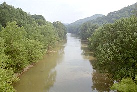
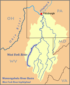
The Monongahela River, sometimes referred to locally as the Mon, is a 130-mile-long (210 km) river on the Allegheny Plateau in north-central West Virginia and Southwestern Pennsylvania. The river flows from the confluence of its west and east forks in north-central West Virginia northeasterly into southwestern Pennsylvania, then northerly to Pittsburgh and its confluence with the Allegheny River to form the Ohio River. The river includes a series of locks and dams that makes it navigable.

<span class="mw-page-title-main">Little Kanawha River</span> River in the United States

The Little Kanawha River is a tributary of the Ohio River, 169 mi (269 km) long, in western West Virginia in the United States. Via the Ohio, it is part of the watershed of the Mississippi River, draining an area of 2,320 mi2 (6,009 km2) on the unglaciated portion of the Allegheny Plateau. It served as an important commercial water route in the early history of West Virginia, particularly in the logging and petroleum industries.

<span class="mw-page-title-main">Cheat River</span> River in West Virginia, United States

The Cheat River is a 78.3-mile-long (126.0 km) tributary of the Monongahela River in eastern West Virginia and southwestern Pennsylvania in the United States. Via the Ohio River, the Cheat and Monongahela are part of the Mississippi River watershed. Owing to the ruggedness of the surrounding Allegheny Mountains, the Cheat remains largely remote with few settlements or developments along its banks. Its headwaters are in the Cheat-Potomac Ranger District of the Monongahela National Forest.

<span class="mw-page-title-main">Greenbrier River</span> River in West Virginia, United States

The Greenbrier River is a tributary of the New River, 162 miles (261 km) long, in southeastern West Virginia, in the United States. Via the New, Kanawha and Ohio rivers, it is part of the watershed of the Mississippi River, draining an area of 1,656 square miles (4,290 km2). It is one of the longest rivers in West Virginia.

<span class="mw-page-title-main">Middle Island Creek</span> River in West Virginia, United States

Middle Island Creek is a river, 77 miles (124 km) long, in northwestern West Virginia in the United States. It is a tributary of the Ohio River, draining an area of 565 square miles (1,463 km2) on the unglaciated Allegheny Plateau. It was named by late 18th century pioneering travelers on the Ohio River, who noted the location of the Creek's mouth opposite Middle Island in the larger river.

<span class="mw-page-title-main">Tygart Valley River</span> River in West Virginia, United States

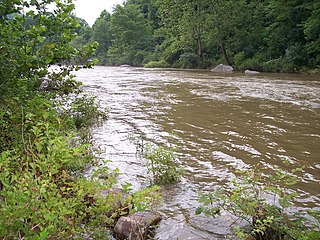
The Tygart Valley River — also known as the Tygart River — is a principal tributary of the Monongahela River, approximately 135 miles (217 km) long, in east-central West Virginia in the United States. Via the Monongahela and Ohio rivers, it is part of the watershed of the Mississippi River, draining an area of 1,329 square miles (3,440 km2) in the Allegheny Mountains and the unglaciated portion of the Allegheny Plateau.

<span class="mw-page-title-main">Black Fork (Cheat River tributary)</span> River in West Virginia, United States

The Black Fork is a principal tributary of the Cheat River in the Allegheny Mountains of eastern West Virginia, USA. It is a short stream, about four miles (6 km) in length, formed by the confluence of two other streams not far above its mouth. It was traditionally considered one of the five Forks of Cheat.

<span class="mw-page-title-main">Dry Fork (Cheat River tributary)</span> River in West Virginia, United States

The Dry Fork is a 39.1-mile-long (62.9 km) tributary of the Black Fork of the Cheat River in the Allegheny Mountains of eastern West Virginia, USA. Via the Black Fork, the Cheat, and the Monongahela and Ohio rivers, it is part of the watershed of the Mississippi River. The Dry Fork flows for much of its length in the Monongahela National Forest and drains mostly rural and forested areas. It was traditionally considered one of the five Forks of Cheat.

<span class="mw-page-title-main">Buckhannon River</span> River in West Virginia, United States

The Buckhannon River is a 45.4-mile-long (73.1 km) tributary of the Tygart Valley River in north-central West Virginia, USA. Via the Tygart Valley, Monongahela and Ohio rivers, it is part of the watershed of the Mississippi River, draining an area of 309 square miles (800 km2) on the unglaciated portion of the Allegheny Plateau. It provides drinking water for much of Upshur County.

<span class="mw-page-title-main">Cherry River (West Virginia)</span> River in West Virginia, United States

The Cherry River is a tributary of the Gauley River in southeastern West Virginia in the United States. Via the Gauley, Kanawha and Ohio rivers, it is part of the watershed of the Mississippi River. The Cherry River drains mostly rural and forested areas and flows for much of its length through the Monongahela National Forest. Throughout its entire length the Cherry goes over a series of whitewater rapids in a mountainous setting.

<span class="mw-page-title-main">Cranberry River (West Virginia)</span> River in West Virginia, United States

The Cranberry River is a tributary of the Gauley River located in southeastern West Virginia in the United States. It is a part of the Mississippi River watershed, by way of the Gauley, Kanawha, and Ohio Rivers, draining an area of 74 square miles (192 km2).

<span class="mw-page-title-main">Stonewall Jackson Lake</span> Lake of the United States of America

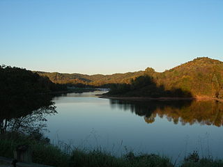
Stonewall Jackson Lake is an 2,630-acre (10.6 km2) impoundment on the West Fork River in Lewis County, West Virginia. The lake is a flood control project of the Pittsburgh District of the United States Army Corps of Engineers and named for Thomas "Stonewall" Jackson, a native of Lewis County. Stonewall Resort is located along the lake's shore. Facilities provided by the Corps of Engineers included a visitors center with public restrooms, a hiking trail, and fishing access.

<span class="mw-page-title-main">Laurel Fork (Cheat River tributary)</span> River in West Virginia, United States

Laurel Fork is a 37.8-mile-long (60.8 km) river in eastern West Virginia, USA. It is a tributary of the Dry Fork; via the Dry Fork, the Black Fork, and the Cheat, Monongahela and Ohio rivers, it is part of the watershed of the Mississippi River, draining an area of 60 square miles (160 km2) in the Allegheny Mountains. With the Dry Fork, the Glady Fork, the Shavers Fork and the Blackwater River, it is considered to be one of the five principal headwaters tributaries of the Cheat River.

<span class="mw-page-title-main">Stonecoal Creek</span> Tributary of West Fork River in West Virginia

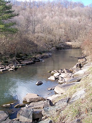
Stonecoal Creek is a tributary of the West Fork River, 12.8 miles (20.6 km) long, in north-central West Virginia in the United States. Via the West Fork, Monongahela and Ohio Rivers, it is part of the watershed of the Mississippi River, draining an area of 41 square miles (110 km2) on the unglaciated portion of the Allegheny Plateau. The stream is believed to have been named in the late 1760s by a group of explorers and settlers, who found coal in nearby hills and mixed with pebbles in the stream.

<span class="mw-page-title-main">Simpson Creek (West Virginia)</span> River in West Virginia, United States

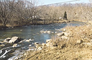
Simpson Creek is a tributary of the West Fork River, 28 miles (45 km) long, in north-central West Virginia, USA. The stream was named for hunter and trapper John Simpson, who left his name on it after building and living in a cabin there for several months in 1763 and '64.

References

  1. 1 2 3 4 Geographic Names Information System. "Geographic Names Information System entry for West Fork River (Feature ID #1548931)" . Retrieved 2007-02-12.
  2. 1 2 Geographic Names Information System. "Geographic Names Information System entry for Straight Fork (Feature ID #1547564)" . Retrieved 2007-02-12.
  3. 1 2 3 Venable, Wallace (2006). "West Fork River". In Ken Sullivan (ed.). The West Virginia Encyclopedia. Charleston, WV: West Virginia Humanities Council. p. 758. ISBN   0-9778498-0-5.
  4. West Virginia Department of Environmental Protection. "Watershed Atlas Project". pp.  West Fork River. Archived from the original on 2005-04-04. Retrieved 2007-02-26.
  5. United States Environmental Protection Agency. "Watershed Report: West Fork River". watersgeo.epa.gov. Archived from the original on 2021-07-03. Retrieved 2021-07-03.
  6. Geographic Names Information System. "Geographic Names Information System entry for Whites Camp Fork (Feature ID #1549092)" . Retrieved 2007-02-12.
  7. DeLorme (1997). West Virginia Atlas & Gazetteer. Yarmouth, Maine: DeLorme. pp. 25, 36. ISBN   0-89933-246-3.
  8. 1 2 3 4 Jernejcic, Frank (March 1995). "Best of the West Fork". Wonderful West Virginia. 59 (1). West Virginia Division of Natural Resources: 2–4.
  9. Meador, Michael M. (2006). "Jackson's Mill". In Ken Sullivan (ed.). The West Virginia Encyclopedia. Charleston, WV: West Virginia Humanities Council. pp. 375–376. ISBN   0-9778498-0-5.
  10. Marion County Parks And Recreation Commission (2006). "Ralph S. LaRue / West Fork River Trail". Archived from the original on 2008-07-31. Retrieved 2007-02-12.
  11. West Virginia Rails-to-Trails Council (2002). "Harrison County Trail" . Retrieved 2007-02-12.
  12. 1 2 3 United States Army Corps of Engineers. "Stonewall Jackson Lake" . Retrieved 2007-02-12.
  13. Johnson, Skip (2006). "Stonewall Jackson Lake". In Ken Sullivan (ed.). The West Virginia Encyclopedia. Charleston, WV: West Virginia Humanities Council. p. 684. ISBN   0-9778498-0-5.
  14. West Virginia Department of Natural Resources (2003). "West Virginia Wildlife Management Areas". Archived from the original on 2008-04-15. Retrieved 2007-02-12.
  15. "Stonewall Resort/Stonewall Jackson Lake State Park" . Retrieved 2007-02-12.
  16. "Clarksburg board plans to remove dams". Charleston Gazette . June 3, 2010. Archived from the original on June 8, 2010. Retrieved June 3, 2010.
  17. "West Fork River Dam Removal Project Underway". West Virginia Public Broadcasting. Associated Press. 2016-03-23. Retrieved 2023-06-28.
  18. Lawrence, Chris (2019-05-04). "Dam removal changes West Fork fishing prospects". WV MetroNews. Retrieved 2023-06-27.
  19. "West Fork River Restoration, West Virginia | U.S. Fish & Wildlife Service". FWS.gov. Retrieved 2023-06-27.

Commons-logo.svg Media related to West Fork River at Wikimedia Commons