Sand Fork, West Virginia

Last updated

Sand Fork, West Virginia
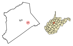
Gilmer County West Virginia Incorporated and Unincorporated areas Sand Fork Highlighted.svg
Location of Sand Fork in Gilmer County, West Virginia.
Coordinates: 38°54′49″N80°45′00″W / 38.91361°N 80.75000°W / 38.91361; -80.75000
Country United States
State West Virginia
County Gilmer
Area
[1]
  Total0.35 sq mi (0.90 km2)
  Land0.33 sq mi (0.84 km2)
  Water0.02 sq mi (0.06 km2)
Elevation
735 ft (224 m)
Population
 (2020) [2]
  Total182
  Estimate 
(2021) [2]
181
  Density455.38/sq mi (175.95/km2)
Time zone UTC-5 (Eastern (EST))
  Summer (DST) UTC-4 (EDT)
ZIP code
26430
Area code 304
FIPS code 54-71620 [3]
GNIS feature ID1546345 [4]

Sand Fork is a town in Gilmer County, West Virginia, United States. The population was 182 at the 2020 census. [2] It is located along the Little Kanawha River, at the mouth of the Sand Fork. [5]

Contents

Sand Fork was incorporated in 1903 as Layopolis, named for William R. Lay, an employee of the Eureka Pipe Line Company, which operated in oil fields in the area. Prior to 1983, the town was known as Layopolis, while its post office was known as Sand Fork. The town's name was changed to Sand Fork by the results of an election in 1983. [6] [7]

Geography

Sand Fork is located at 38°54′49″N80°45′00″W / 38.913684°N 80.749976°W / 38.913684; -80.749976 (38.913684, -80.749976). [8]

According to the United States Census Bureau, the town has a total area of 0.35 square miles (0.91 km2), of which 0.33 square miles (0.85 km2) is land and 0.02 square miles (0.05 km2) is water. [9]

Demographics

Historical population
CensusPop.Note
1970 252
1980 28011.1%
1990 196−30.0%
2000 176−10.2%
2010 159−9.7%
2020 18214.5%
2021 (est.)181 [2] −0.5%
U.S. Decennial Census [10]

2010 census

As of the census [11] of 2010, there were 159 people, 60 households, and 45 families living in the town. The population density was 481.8 inhabitants per square mile (186.0/km2). There were 68 housing units at an average density of 206.1 per square mile (79.6/km2). The racial makeup of the town was 98.1% White and 1.9% from two or more races.

There were 60 households, of which 43.3% had children under the age of 18 living with them, 56.7% were married couples living together, 15.0% had a female householder with no husband present, 3.3% had a male householder with no wife present, and 25.0% were non-families. 25.0% of all households were made up of individuals, and 15% had someone living alone who was 65 years of age or older. The average household size was 2.65 and the average family size was 3.16.

The median age in the town was 35.5 years. 29.6% of residents were under the age of 18; 5.6% were between the ages of 18 and 24; 25.2% were from 25 to 44; 23.9% were from 45 to 64; and 15.7% were 65 years of age or older. The gender makeup of the town was 44.0% male and 56.0% female.

2000 census

As of the census [3] of 2000, there were 176 people, 68 households, and 51 families living in the town. The population density was 501.1 inhabitants per square mile (194.2/km2). There were 82 housing units at an average density of 233.5 per square mile (90.5/km2). The racial makeup of the town was 98.30% White, and 1.70% from two or more races.

There were 68 households, out of which 32.4% had children under the age of 18 living with them, 60.3% were married couples living together, 10.3% had a female householder with no husband present, and 25.0% were non-families. 23.5% of all households were made up of individuals, and 19.1% had someone living alone who was 65 years of age or older. The average household size was 2.59 and the average family size was 2.96.

In the town, the population was spread out, with 23.9% under the age of 18, 8.0% from 18 to 24, 25.6% from 25 to 44, 26.1% from 45 to 64, and 16.5% who were 65 years of age or older. The median age was 39 years. For every 100 females, there were 93.4 males. For every 100 females age 18 and over, there were 91.4 males.

The median income for a household in the town was $30,179, and the median income for a family was $33,750. Males had a median income of $23,750 versus $24,167 for females. The per capita income for the town was $14,223. About 17.2% of families and 21.2% of the population were below the poverty line, including 21.4% of those under the age of eighteen and 26.1% of those 65 or over.
Points of interest

This small town has several interesting features. There is an early historic general store, several churches, an elementary school and a number of businesses. There is a trail head located near the town of Sandfork for an extensive set of unnamed off-road vehicle (ORV) trails. These trails are located on private land but access is unrestricted. The trail system is best suited to small vehicles but some trails are accessible by full-size ORVs.[ citation needed ]

Related Research Articles

<span class="mw-page-title-main">Rio Grande County, Colorado</span> County in Colorado, United States

Rio Grande County is a county located in the U.S. state of Colorado. As of the 2020 census, the population was 11,539. The county seat is Del Norte. The county is named for the Rio Grande, which flows through the county.

<span class="mw-page-title-main">Grantsville, West Virginia</span> Town in West Virginia, United States

Grantsville is a town in Calhoun County, West Virginia, United States. The population was 482 at the 2020 census. It is the county seat of Calhoun County. The town was established along the Little Kanawha River in 1865 and named for Ulysses S. Grant. Grantsville is home to Wayne Underwood Park, which includes a .25-mile-long (0.40 km) walking trail, and to the annual West Virginia Wood Festival.

<span class="mw-page-title-main">Lumberport, West Virginia</span> Town in West Virginia, United States

Lumberport is a town in Harrison County, located in northern West Virginia, United States. The population was 720 at the 2020 census.

<span class="mw-page-title-main">West Milford, West Virginia</span> Town in West Virginia, United States

West Milford is a town in Harrison County, West Virginia, United States. The population was 452 at the 2020 census.

<span class="mw-page-title-main">Bolivar, West Virginia</span> Town in West Virginia, United States

Bolivar is a town in Jefferson County, West Virginia, United States. The population was 1,072 at the 2020 census. The town is named for South American revolutionary leader Simón Bolívar. Located in West Virginia's Eastern Panhandle, it is part of the northwestern fringes of the Washington metropolitan area.

<span class="mw-page-title-main">Worthington, West Virginia</span> Town in West Virginia, United States

Worthington is a town in Marion County, West Virginia, United States. The population was 158 at the 2010 census. Worthington was incorporated in 1893 and named for Colonel George Worthington, an early settler. U.S. Route 19 passes through the town.

<span class="mw-page-title-main">Northfork, West Virginia</span> Town in West Virginia, United States

Northfork is a town in McDowell County, West Virginia, United States, located on U.S. Route 52 between Welch and Bluefield.

<span class="mw-page-title-main">War, West Virginia</span> City in West Virginia, United States

War is a city in McDowell County, West Virginia, United States. The population was 690 at the 2020 census. War was incorporated in 1920 by the Circuit Court of McDowell County. Its name is derived from War Creek, whose confluence with Dry Fork is located within the city. War is the only place in the United States with this name. War was formerly known as Miner's City.

<span class="mw-page-title-main">Bramwell, West Virginia</span> Town in West Virginia, United States

Bramwell is a town in Mercer County, West Virginia, United States, along the Bluestone River. The population was 277 at the 2020 census. It is part of the Bluefield, WV-VA micropolitan area which has a population of 107,578.

<span class="mw-page-title-main">Kermit, West Virginia</span> Town in West Virginia, United States

Kermit is a town in Mingo County, West Virginia, United States. The population was 406 at the 2010 census. Kermit is located along the Tug Fork, opposite Warfield, Kentucky. The Norfolk Southern Railway's Kenova District runs through town.

<span class="mw-page-title-main">Matewan, West Virginia</span> Town in West Virginia, United States

Matewan is a town in Mingo County, West Virginia, United States at the confluence of the Tug Fork River and Mate Creek. The population was 412 at the 2020 census, down from 499 in 2010. The Norfolk Southern Railway's Pocahontas District passes through the town. It was a key site of the Coal Wars and the location of the Battle of Matewan in 1920.

<span class="mw-page-title-main">Durbin, West Virginia</span> Town in West Virginia, United States

Durbin is a town in Pocahontas County, West Virginia, United States. The population was 235 at the 2020 census.

<span class="mw-page-title-main">Cairo, West Virginia</span> Town in West Virginia, United States

Cairo is a town in Ritchie County, West Virginia, United States, along West Virginia Route 31, the North Fork of the Hughes River, and the North Bend Rail Trail. The population was 174 at the 2020 census.

<span class="mw-page-title-main">Ellenboro, West Virginia</span> Town in West Virginia, United States

Ellenboro is a town in Ritchie County, West Virginia, United States. The population was 222 at the 2020 census. The town is located at the junction of U.S. Route 50 and West Virginia Route 16; the North Bend Rail Trail also passes through the town. The town was named for Ellen Mariah Williamson, the eldest daughter of the family that granted a right of way for the Baltimore and Ohio Railroad to build their line through the town; an earlier name for the community was Shumley. Ellenboro was incorporated in 1903.

<span class="mw-page-title-main">Pennsboro, West Virginia</span> City in West Virginia, United States

Pennsboro is a city in Ritchie County, West Virginia, United States. The population was 1,050 at the 2020 census. The city is located at the junction of U.S. Route 50 and West Virginia Route 74; the North Bend Rail Trail also passes through the city.

<span class="mw-page-title-main">Reedy, West Virginia</span> Town in West Virginia, United States

Reedy is a town in Roane County, West Virginia, United States. The population was 152 at the 2020 census.

<span class="mw-page-title-main">Davis, West Virginia</span> Town in West Virginia, United States

Davis is a town in Tucker County, West Virginia, United States, situated along the Blackwater River. The population was 595 at the 2020 census.

<span class="mw-page-title-main">Hambleton, West Virginia</span> Town in West Virginia, United States

Hambleton is a town in Tucker County, West Virginia, United States. The population was 216 at the 2020 census. Hambleton was established in 1889, but not incorporated until 1905. It was named by then United States Senator Stephen B. Elkins in honor of a stockholder by this name in the West Virginia Central Railroad Company. The town was previously known as Hulings.

<span class="mw-page-title-main">Oceana, West Virginia</span> Town in West Virginia, United States

Oceana is a town in Wyoming County, West Virginia. The population was 1,462 at the time of the 2020 census. Oceana is the oldest city in Wyoming County and was the county seat until 1907.

<span class="mw-page-title-main">Granger, Wyoming</span> Town in Sweetwater County, Wyoming, United States

Granger is a town along Blacks Fork near the western edge of Sweetwater County, Wyoming, United States. The population was 139 at the 2010 census. It is located near the confluence of the Blacks Fork and the Hams Fork rivers. The geography of the area is flat with semi-arid scrub.

References

  1. "2019 U.S. Gazetteer Files". United States Census Bureau. Retrieved August 7, 2020.
  2. 1 2 3 4 Bureau, US Census. "City and Town Population Totals: 2020-2021". Census.gov. US Census Bureau. Retrieved July 3, 2022.
  3. 1 2 "U.S. Census website". United States Census Bureau . Retrieved January 31, 2008.
  4. "US Board on Geographic Names". United States Geological Survey. October 25, 2007. Retrieved January 31, 2008.
  5. West Virginia Atlas & Gazetteer. Yarmouth, Me.: DeLorme. 1997. p. 35. ISBN   0-89933-246-3.
  6. Kenny, Hamill (1945). West Virginia Place Names: Their Origin and Meaning, Including the Nomenclature of the Streams and Mountains. Piedmont, West Virginia: The Place Name Press. p. 552.
  7. West Virginia Blue Book. Published annually by the Clerk's Office of the West Virginia Senate.
  8. "US Gazetteer files: 2010, 2000, and 1990". United States Census Bureau. February 12, 2011. Retrieved April 23, 2011.
  9. "US Gazetteer files 2010". United States Census Bureau. Archived from the original on January 25, 2012. Retrieved January 24, 2013.
  10. "Census of Population and Housing". Census.gov. Retrieved June 4, 2015.
  11. "U.S. Census website". United States Census Bureau . Retrieved January 24, 2013.