Rivesville, West Virginia

Last updated

Rivesville, West Virginia
Marion County West Virginia Incorporated and Unincorporated areas Rivesville Highlighted.svg
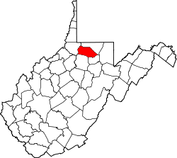
Location of Rivesville in Marion County, West Virginia.
Coordinates: 39°31′49″N80°7′9″W / 39.53028°N 80.11917°W / 39.53028; -80.11917
Country United States
State West Virginia
County Marion
Area
[1]
  Total0.59 sq mi (1.54 km2)
  Land0.52 sq mi (1.36 km2)
  Water0.07 sq mi (0.18 km2)
Elevation
866 ft (264 m)
Population
 (2020) [2]
  Total830
  Estimate 
(2021) [2]
823
  Density1,723.28/sq mi (664.98/km2)
Time zone UTC-5 (Eastern (EST))
  Summer (DST) UTC-4 (EDT)
ZIP code
26588
Area code 304
FIPS code 54-68908 [3]
GNIS feature ID1545784 [4]

Rivesville is a town and former coal town in Marion County, West Virginia, United States. The population was 830 at the 2020 census. [2]

Contents

Geography

Rivesville is located at 39°31′49″N80°7′9″W / 39.53028°N 80.11917°W / 39.53028; -80.11917 (39.530276, -80.119063) [5] in the heart of the Fairmont coal field [6] on the north-west bank of the Monongahela River around its confluence with Paw Paw Creek.

According to the United States Census Bureau, the town has a total area of 0.59 square miles (1.53 km2), of which 0.52 square miles (1.35 km2) is land and 0.07 square miles (0.18 km2) is water. [7]

Demographics

Historical population
CensusPop.Note
1860 54
1870 6316.7%
1880 136115.9%
1890 16521.3%
1900 164−0.6%
1910 19015.9%
1920 1,061458.4%
1930 1,70060.2%
1940 1,552−8.7%
1950 1,343−13.5%
1960 1,191−11.3%
1970 1,108−7.0%
1980 1,32719.8%
1990 1,064−19.8%
2000 913−14.2%
2010 9342.3%
2020 830−11.1%
2021 (est.)823 [2] −0.8%
U.S. Decennial Census [8]

2010 census

As of the census [9] of 2010, there were 934 people, 402 households, and 261 families living in the town. The population density was 1,796.2 inhabitants per square mile (693.5/km2). There were 430 housing units at an average density of 826.9 per square mile (319.3/km2). The racial makeup of the town was 98.7% White, 0.6% African American, 0.5% Native American, and 0.1% from other races. Hispanic or Latino of any race were 0.3% of the population.

There were 402 households, of which 29.1% had children under the age of 18 living with them, 44.3% were married couples living together, 14.7% had a female householder with no husband present, 6.0% had a male householder with no wife present, and 35.1% were non-families. 29.9% of all households were made up of individuals, and 15.1% had someone living alone who was 65 years of age or older. The average household size was 2.32 and the average family size was 2.83.

The median age in the town was 42.1 years. 21.1% of residents were under the age of 18; 6% were between the ages of 18 and 24; 26.3% were from 25 to 44; 30.1% were from 45 to 64; and 16.6% were 65 years of age or older. The gender makeup of the town was 46.6% male and 53.4% female.

2000 census

As of the census [3] of 2000, there were 913 people, 400 households, and 268 families living in the town. The population density was 1,602.5 inhabitants per square mile (618.4/km2). There were 450 housing units at an average density of 789.8 per square mile (304.8/km2). The racial makeup of the town was 98.80% White, 0.11% African American, 0.11% Native American, 0.33% Asian, and 0.66% from two or more races. Hispanic or Latino of any race were 0.55% of the population.

There were 400 households, out of which 24.8% had children under the age of 18 living with them, 52.0% were married couples living together, 11.0% had a female householder with no husband present, and 33.0% were non-families. 30.8% of all households were made up of individuals, and 19.3% had someone living alone who was 65 years of age or older. The average household size was 2.28 and the average family size was 2.80.

In the town, the population was spread out, with 19.1% under the age of 18, 7.6% from 18 to 24, 25.0% from 25 to 44, 27.8% from 45 to 64, and 20.6% who were 65 years of age or older. The median age was 44 years. For every 100 females, there were 87.5 males. For every 100 females age 18 and over, there were 83.8 males.

The median income for a household in the town was $25,700, and the median income for a family was $35,417. Males had a median income of $26,875 versus $19,063 for females. The per capita income for the town was $14,085. About 16.4% of families and 19.9% of the population were below the poverty line, including 32.9% of those under age 18 and 12.9% of those age 65 or over.

History

The area was populated by some of the earliest settlers to the area, with the safety of Prickett's Fort sitting directly across the Monongahela River. David Morgan (frontiersman) moved there in 1772. That's also the location where he saved his family from an attack by Indians in 1778, based on a fevered dream he had, while recuperating from an illness at the fort. The house still stands there in Rivesville. [10] Now known as the Morgan-Gold House, it was listed on the National Register of Historic Places in 1985. [11]

Rivesville was platted in 1837, and named after William Cabell Rives. [12]

In 1900, it was a very small town, population 164, growing to 190 in 1910. This was immediately before the development of large-scale coal mining in the area and the subsequent population growth. [13]

In the early 20th century, Rivesville was at the junction between the Pawpaw branch of the B&O Railroad and the Buckhannon & Northern Railroad, a branch of the Pittsburgh and Lake Erie a predecessor that was incorporated into the Monongahela Railway formed in 1915. [14]

Rivesville was also served by the Fairmont-Clarksburg Division of the Monongahela-West Pen Railways, originally the Monongahela Power and Railway Company. This electric interurban line ran from Fairmont through Rivesville to the Rivesville Power Station, just north of town. [15]

Institutions

Schools

The Rivesville Elementary/Middle school, formerly Rivesville High School, is administered by the Marion County Schools. [16] It has 37 teachers and has been affiliated with the West Virginia University Benedum Collaborative as a Professional Development School since 1997. Tyson Furgason is currently principal. Based on 2007 test scores, the school ranked close to average for the state of West Virginia. In 2007, the school enrolled 338 students between kindergarten and grade 8.

Power plant

The Rivesville Power Plant was built by Monongahela Power and Railway Company in 1919 and is currently operated by Allegheny Energy. [17] Unit 5, installed in 1944 had a power output of 48 megawatts; Unit 6, installed in 1951, was 94 megawatts. [18] [19] [20] The plant used open loop cooling, drawing up to 69.8 million gallons per day of cooling water from the Monongahela River. [21] The coal stockpile at the plant had a capacity of 50,000 tons, and coal was delivered by barge. [22] Earlier, coal was delivered by rail. [23] The plant was connected to the grid by 138Kv transmission lines. [24] In the mid 1970s, this was the first commercial power plant to use fluidized bed combustion to fire its boilers. [25] As of 2007, this power plant employed 33 people. [26] New environmental regulations forced the company to shut down the plant in 2012, along with two others elsewhere in the state. [27]

Coal mining

About the only area around Rivesville where the coal has not been mined out is directly under the older portion of the town and under the riverbed. Consolidation Coal Company Mine No. 97 was in the Pittsburgh coal seam around 100 feet below the level of the riverbed. This mine operated between 1922 and 1954, with a peak production of 670408 tons per year. [28] The coal seam itself is 6 to 8 feet thick. The number 97 Hoist Shaft was directly west of the westernmost corner of the Power Plant, with the hoisting engines to the north across the tracks. Consol. Mine No. 24 was directly across the river, with its shaft in the company town of Montana Mines, and in 1943, plans were filed to connect these mines with an under-river crossing. [29] In 1934, Consol. No. 97 employed 412 men, all of whom were UMWA members. The daily wage ranged from $6.37 for loaders to $9.29 for cutters. [30]

The Parker Run Coal & Coke Co. Mine at Rivesville, circa 1913. ParkerRunTipple.jpg
The Parker Run Coal & Coke Co. Mine at Rivesville, circa 1913.

Other mines in the area exploited the shallower Sewickley Coal Seam, largely above the river level to the north and east. Between 1901 and 1913, [31] [32] for example, the Parker Run Coal and Coke Company operated a mine just east of Rivesville, shipping coal by rail and barge. In 1910, this mine employed 60 miners. [33] In 1913, it employed 10 laborers and 25 miners to take 500 tons of coal a day. The coal in this seam was over 6 feet thick, but higher in sulfur than the Pittsburgh seam. Mines in the Sewickley seam were opened earlier and mined out earlier than the mines in the Pittsburgh Seam. [34]

In 1913, the Monongahela Valley Traction Company had a mine in the even shallower Waynesburg coal seam about a mile southwest of Rivesville near Dakota. This coal seam was about 5 feet thick, including an intermediate shale bed one foot thick. [35] By 1921, Monongahela Traction had opened a second mine in the area near Baxter, about a mile up Paw Paw creek. [36] As of 1921, other mines listed as being in Rivesville included the Rivesville Coal Company's Hood Mine, the Winfield Coal Company's River Side Mine, and the Virginia & Pittsburgh Coal & Coke Co.'s Morgan mine.

Notable person

Related Research Articles

<span class="mw-page-title-main">Monongalia County, West Virginia</span> County in West Virginia, United States

Monongalia County, known locally as Mon County, is located in the U.S. state of West Virginia. As of the 2020 census, the population was 105,822, making it West Virginia's third-most populous county. Its county seat is Morgantown. The county was founded in 1776. Monongalia County is included in the Morgantown, WV Metropolitan Statistical Area, and is the largest county in North-Central West Virginia. It is part of the Pittsburgh media market.

<span class="mw-page-title-main">Marion County, West Virginia</span> County in West Virginia, United States

Marion County is a county in the U.S. state of West Virginia. As of the 2020 census, the population was 56,205. Its county seat is Fairmont. The county was named in honor of General Francis Marion, known to history as "The Swamp Fox".

<span class="mw-page-title-main">Bussey, Iowa</span> City in Iowa, United States

Bussey is a city in southeast Marion County, Iowa, United States. The population was 387 at the time of the 2020 census.

<span class="mw-page-title-main">Bethel Park, Pennsylvania</span> Borough in Pennsylvania, United States

Bethel Park is a borough with home rule status in Allegheny County, Pennsylvania, United States. It is a suburb within the Pittsburgh metropolitan area, located approximately 7 miles (11 km) south of Pittsburgh. The population was 33,577 as of the 2020 census.

<span class="mw-page-title-main">East Pittsburgh, Pennsylvania</span> Borough in Pennsylvania, United States

East Pittsburgh is a borough in Allegheny County, Pennsylvania, United States, approximately 11 miles (18 km) southeast of the confluence of the Monongahela and the Allegheny rivers at Pittsburgh. The population in 1900 stood at 2,883, and in 1910, at 5,615. As of the 2020 census, the borough population was 1,927, having fallen from 6,079 in 1940. George Westinghouse erected large works there which supplied equipment to the great power plants at Niagara Falls and for the elevated and rapid-transit systems of New York City. Nearby, the George Westinghouse Bridge over Turtle Creek is a prominent fixture in the area, which is very near the borough of Braddock.

<span class="mw-page-title-main">Elizabeth, Pennsylvania</span> Borough in Pennsylvania, United States

Elizabeth is a borough in Allegheny County, Pennsylvania, United States, on the east bank of the Monongahela River, where Pennsylvania Route 51 crosses, 15 miles (24 km) upstream (south) of Pittsburgh and close to the county line. The population was 1,398 at the 2020 census. The borough of Elizabeth is entirely contained within the 15037 USPS ZIP code. The local school district is the Elizabeth Forward School District. The borough is home to neighborhoods Walker Heights and Town Hill. Elizabeth Borough is the birthplace of Town Hill Hockey established in 1978.

<span class="mw-page-title-main">Forward Township, Allegheny County, Pennsylvania</span> Township of Allegheny County, Pennsylvania

Forward Township is a township in Allegheny County, Pennsylvania, United States. The population was 3,068 at the 2020 census. The township is named after Walter Forward, U.S. Secretary of the Treasury from 1841 to 1843.

<span class="mw-page-title-main">North Braddock, Pennsylvania</span> Borough in Pennsylvania, United States

North Braddock is a borough in Allegheny County, Pennsylvania, United States, along the Monongahela River. The 2020 census had the borough population at 4,320. It is a suburb 11 miles (18 km) east of Pittsburgh. Organized from a part of Braddock Township in 1897, the borough prides itself in being the "Birthplace of Steel" as the home of Andrew Carnegie's Edgar Thomson Steel Works that opened in 1875.

<span class="mw-page-title-main">Springdale, Pennsylvania</span> Borough in Pennsylvania, United States

Springdale is a borough in northeastern Allegheny County, Pennsylvania, United States, 18 miles (29 km) northeast of Pittsburgh along the Allegheny River. The population was 3,400 at the 2020 census. The borough became official in 1906, after breaking away from the township.

<span class="mw-page-title-main">West Elizabeth, Pennsylvania</span> Borough in Pennsylvania, United States

West Elizabeth is a borough in Allegheny County, Pennsylvania, United States. The population was 403 at the 2020 census.

<span class="mw-page-title-main">West Mifflin, Pennsylvania</span> Borough in Pennsylvania, United States

West Mifflin is a borough in Allegheny County, Pennsylvania, United States, located southeast of downtown Pittsburgh. The population was 19,589 at the 2020 census. It is named after Thomas Mifflin, 1st Governor of Pennsylvania, signer of the United States Constitution, and 1st Quartermaster General of the United States Army.

<span class="mw-page-title-main">Greensboro, Pennsylvania</span> Historic district in Pennsylvania, United States

Greensboro is a borough in Greene County, Pennsylvania, United States. The population was 267 at the 2020 census, up from 260 at the 2010 census.

<span class="mw-page-title-main">Nemacolin, Pennsylvania</span> Census-designated place in Pennsylvania, United States

Nemacolin is a census-designated place (CDP) in Greene County, Pennsylvania, United States. It was founded as a company town around the workings of a Youngstown Sheet and Tube Company that owned and operated a coal mine in 1917. The name reflects a noted Amerindian ally Chief Nemacolin, who showed the Virginia and Pennsylvania settlers how to cross the successive Allegheny barrier ridges via the Cumberland Narrows and the Nemacolin Trail—which Braddock Expedition widened into a wagon road through the mountains. The population of the CDP was 937 at the 2010 census.

<span class="mw-page-title-main">Charleroi, Pennsylvania</span> Borough in Pennsylvania, United States

Charleroi is a borough in Washington County, Pennsylvania, United States, along the Monongahela River, 21 miles south of Pittsburgh.

<span class="mw-page-title-main">Fairmont, West Virginia</span> City in West Virginia, United States

Fairmont is a city in and county seat of Marion County, West Virginia, United States. The population was 18,313 at the 2020 census, making it the eighth-largest city in the state. It is the principal city of the Fairmont micropolitan area, which includes all of Marion County in North Central West Virginia and had a population of 56,205 in 2020. Fairmont is also a principal city of the larger Morgantown–Fairmont combined statistical area.

<span class="mw-page-title-main">Farmington, West Virginia</span> Town in West Virginia, United States

Farmington is a town in Marion County, West Virginia, United States. The population was 389 at the 2020 census. The small town is situated on Buffalo Creek and the Allegheny Mountains about 6 miles west of Fairmont, Marion County's county seat. It is best known for being the site of the 1968 Farmington Mine disaster.

<span class="mw-page-title-main">Grant Town, West Virginia</span> Town in West Virginia, United States

Grant Town is a town in Marion County, West Virginia, in the eastern United States. The population was 690 at the 2020 census.

<span class="mw-page-title-main">Monongah, West Virginia</span> Town in West Virginia, United States

Monongah is a town in Marion County, West Virginia, United States, situated where Booths Creek flows into the West Fork River. The population was 972 at the 2020 census. Monongah was chartered in 1891, based on Chapter 47 of West Virginia code. Its name is derived from the nearby Monongahela River.

<span class="mw-page-title-main">Piedmont, West Virginia</span> Town in West Virginia, United States

Piedmont is a town in Mineral County, West Virginia, United States. It is part of the Cumberland, MD-WV metropolitan statistical area. The population was 716 at the 2020 census. Piedmont was chartered in 1856 and the town is the subject of Colored People: A Memoir by Piedmont native Henry Louis Gates Jr.

<span class="mw-page-title-main">Pittsburgh coal seam</span>

The Pittsburgh coal seam is the thickest and most extensive coal bed in the Appalachian Basin; hence, it is the most economically important coal bed in the eastern United States. The Upper Pennsylvanian Pittsburgh coal bed of the Monongahela Group is extensive and continuous, extending over 11,000 mi2 through 53 counties. It extends from Allegany County, Maryland to Belmont County, Ohio and from Allegheny County, Pennsylvania southwest to Putnam County, West Virginia.

References

  1. "2019 U.S. Gazetteer Files". United States Census Bureau. Retrieved August 7, 2020.
  2. 1 2 3 4 "City and Town Population Totals: 2020-2021". Census.gov. US Census Bureau. Retrieved July 3, 2022.
  3. 1 2 "U.S. Census website". United States Census Bureau . Retrieved January 31, 2008.
  4. "US Board on Geographic Names". United States Geological Survey. October 25, 2007. Retrieved January 31, 2008.
  5. "US Gazetteer files: 2010, 2000, and 1990". United States Census Bureau. February 12, 2011. Retrieved April 23, 2011.
  6. Coalfields of the Appalachian Mountains
  7. "US Gazetteer files 2010". United States Census Bureau. Archived from the original on January 25, 2012. Retrieved January 24, 2013.
  8. "Census of Population and Housing". Census.gov. Retrieved June 4, 2015.
  9. "U.S. Census website". United States Census Bureau . Retrieved January 24, 2013.
  10. Ruth, Frances D., National Register of Historic Places Inventory Nomination Form: Morgan-Gold House. State of West Virginia, West Virginia Division of Culture and History, Historic Preservation.
  11. National Register Information System, National Register of Historic Places, National Park Service, March 13, 2009
  12. Kenny, Hamill (1945). West Virginia Place Names: Their Origin and Meaning, Including the Nomenclature of the Streams and Mountains. Piedmont, WV: The Place Name Press. p. 533.
  13. Ray V. Hennen, David B. Berger, I.C. White, West Virginia Geological Survey, Marion, Monongalia and Taylor Counties, Wheeling News Litho. Co., Wheeling, 1913, page 35.
  14. "The History of the Monongahela Coalfields - 1900 to the Present". Archived from the original on May 9, 2008. Retrieved October 17, 2008.
  15. Monongahela - West Pen part of Bill's Trolley Pages
  16. List of schools from the Marion County Schools web page
  17. Huilan Li, Economic Evaluation of Air Pollution Reduction of Phase I Power Plants in West Virginia: An Output Distance Function Approach [ permanent dead link ], PhD thesis, West Virginia University, 2006. See Appendix D.
  18. "Allegheny Generating Company, Form 10-K405, Filing Date Mar 30, 2001". secdatabase.com. Retrieved May 14, 2018.
  19. Allegheny Energy, Form 8-K SEC filing, October 31, 2000.
  20. Monongahela Power Co., Form POS AMC SEC filing, April 4, 1994.
  21. Water Use Benchmarks for Thermoelectric Power Generation Archived June 12, 2010, at the Wayback Machine , Department of Geography and Environmental Resources, Southern Ill. U., August 15, 2006
  22. U.S. Army Corps of Engineers, Port Series No. 60, Pittsburgh, PA, and Ports on the Ohio, Monongahela, and Allegheny Rivers Archived January 9, 2009, at the Wayback Machine , 2004 Survey
  23. Pennsylvania Trolley Museum, Monongahela Valley Traction Company Car #3000 Archived November 21, 2008, at the Wayback Machine , October 17, 2005.
  24. Electric Industry Restructuring Group,Electric Industry Restructuring: Opportunities and Risks for West Virginia, Interim Report No. 5: Transmission Enhancement and Expansion Archived September 8, 2008, at the Wayback Machine , West Virginia University, January 1998. Section 5.2.
  25. Fluidized Bed Technology -- An R&D Success Story, U.S. Department of Energy, October 24, 2006.
  26. Allegheny Energy's Harrison and Rivesville Power Stations Recertified as VPP Star Worksites Allegheny Energy press release, November 15, 2007.
  27. FirstEnergy, Citing Impact of Environmental Regulations, Will Retire Three Coal-Fired Power Plants in West Virginia Archived February 22, 2014, at the Wayback Machine , FirstEnergy press release, February 8, 2012.
  28. "Mine Data Tonnage Reports for Consolidation No. 97". West Virginia Office of Miners' Health Safety & Training. Archived from the original on September 27, 2011. Retrieved June 16, 2009.
  29. Document No. 904913 West Virginia Coal Bed Mapping Project
  30. letter from Henry W. Francis to the Federal Emergency Relief Administration Archived March 3, 2016, at the Wayback Machine dated November 25, 1934.
  31. Samuel B. Brown, Bulletin No. 1, West Virginia Geologic Survey, Acme Publishing Co., Morgantown, 1901, page 343
  32. "Mine Data Tonnage Reports for Parker Run Coal & Coke". West Virginia Office of Miners' Health Safety & Training. Archived from the original on September 27, 2011. Retrieved June 16, 2009.
  33. Annual Report of the Department of Mines for the Year Ending June 30, 1910, West Virginia Department of Mines, The News Mail Co., Charleston, 1911, page 18
  34. Ray V. Hennen, David B. Berger, I.C. White, West Virginia Geological Survey, Marion, Monongalia and Taylor Counties, Wheeling News Litho. Co., Wheeling, 1913, pages 660-661.
  35. Ray V. Hennen, David B. Berger, I.C. White, West Virginia Geological Survey, Marion, Monongalia and Taylor Counties, Wheeling News Litho. Co., Wheeling, 1913, page 242.
  36. List of Coal Mines in West Virginia, July 1, 1921, West Virginia Geological Survey, page 14.