Shagtown, West Virginia

Last updated
Shagtown
Unincorporated community
USA West Virginia location map.svg
Red pog.svg
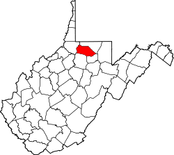
Shagtown
Location within the state of West Virginia
Usa edcp location map.svg
Red pog.svg
Shagtown
Shagtown (the US)
Coordinates: 39°29′30″N80°7′46″W / 39.49167°N 80.12944°W / 39.49167; -80.12944 Coordinates: 39°29′30″N80°7′46″W / 39.49167°N 80.12944°W / 39.49167; -80.12944
Country United States
State West Virginia
County Marion
Elevation 1,004 ft (306 m)
Time zone Eastern (EST) (UTC-5)
  Summer (DST) EDT (UTC-4)
GNIS ID 1718196 [1]

Shagtown is an unincorporated community in Marion County, West Virginia, United States.

Unincorporated area Region of land not governed by own local government

In law, an unincorporated area is a region of land that is not governed by a local municipal corporation; similarly an unincorporated community is a settlement that is not governed by its own local municipal corporation, but rather is administered as part of larger administrative divisions, such as a township, parish, borough, county, city, canton, state, province or country. Occasionally, municipalities dissolve or disincorporate, which may happen if they become fiscally insolvent, and services become the responsibility of a higher administration. Widespread unincorporated communities and areas are a distinguishing feature of the United States and Canada. In most other countries of the world, there are either no unincorporated areas at all, or these are very rare; typically remote, outlying, sparsely populated or uninhabited areas.

Marion County, West Virginia county in West Virginia, United States

Marion County is a county in the U.S. state of West Virginia. As of the 2010 census, the population was 56,418. Its county seat is Fairmont. The county was named in honor of General Francis Marion, known to history as "The Swamp Fox".

West Virginia State of the United States of America

West Virginia is a state located in the Appalachian region in the Southern United States and is also considered to be a part of the Middle Atlantic States. It is bordered by Pennsylvania to the north, Maryland to the east and northeast, Virginia to the southeast, Kentucky to the southwest, and Ohio to the northwest. West Virginia is the 41st largest state by area, and is ranked 38th in population. The capital and largest city is Charleston.

Related Research Articles

Ohio River river in the eastern United States

The Ohio River, which flows southwesterly from Pittsburgh, Pennsylvania, to Cairo, Illinois, is the largest tributary, by volume, of the Mississippi River in the United States. At the confluence, the Ohio is considerably bigger than the Mississippi and, thus from a hydrological perspective, is the main stream of the whole river system.

Charleston, West Virginia Capital of West Virginia

Charleston is the most populous city in, and the capital of, the U.S. state of West Virginia. Located at the confluence of the Elk and Kanawha rivers, the population during the 2016 Census Estimate was 49,138. The Charleston metropolitan area as a whole had 217,916 residents. Charleston is the center of government, commerce, and industry for Kanawha County, of which it is the county seat.

Potomac River river in the mid-Atlantic United States

The Potomac River is located within the Mid-Atlantic region of the United States and flows from the Potomac Highlands into the Chesapeake Bay. The river is approximately 405 miles (652 km) long, with a drainage area of about 14,700 square miles (38,000 km2). In terms of area, this makes the Potomac River the fourth largest river along the Atlantic coast of the United States and the 21st largest in the United States. Over 5 million people live within the Potomac watershed.

Shenandoah Valley valley and cultural region of western Virginia and the Eastern Panhandle of West Virginia in the United States

The Shenandoah Valley is a geographic valley and cultural region of western Virginia and the Eastern Panhandle of West Virginia in the United States. The valley is bounded to the east by the Blue Ridge Mountains, to the west by the eastern front of the Ridge-and-Valley Appalachians, to the north by the Potomac River and to the south by the James River. The cultural region covers a larger area that includes all of the valley plus the Virginia highlands to the west, and the Roanoke Valley to the south. It is physiographically located within the Ridge and Valley province and is a portion of the Great Appalachian Valley.

West Virginia University public university in Morgantown, West Virginia, United States

West Virginia University (WVU) is a public, land-grant, space-grant, research-intensive university in Morgantown, West Virginia, United States. Its other campuses include the West Virginia University Institute of Technology in Beckley and Potomac State College of West Virginia University in Keyser; and a second clinical campus for the University's medical and dental schools at Charleston Area Medical Center in Charleston. WVU Extension Service provides outreach with offices in all of West Virginia's 55 counties. Since 2001, WVU has been governed by the West Virginia University Board of Governors.

Allegheny Mountains mountain range

The Allegheny Mountain Range, informally the Alleghenies and also spelled Alleghany and Allegany, is part of the vast Appalachian Mountain Range of the Eastern United States and Canada and posed a significant barrier to land travel in less technologically advanced eras. The barrier range has a northeast–southwest orientation and runs for about 400 miles (640 km) from north-central Pennsylvania, through western Maryland and eastern West Virginia, to southwestern Virginia.

United States congressional delegations from West Virginia Wikimedia list article

These are tables of congressional delegations from West Virginia to the United States House of Representatives and the United States Senate.

Take Me Home, Country Roads song

"Take Me Home, Country Roads", also known as "Take Me Home" or "Country Roads", is a song written by Bill Danoff, Taffy Nivert, and John Denver about the state of West Virginia. It was released as a single performed by Denver on April 12, 1971, peaking at number 2 on Billboard's US Hot 100 singles for the week ending August 28, 1971. The song was a success on its initial release and was certified Gold by the RIAA on August 18, 1971, and Platinum on April 10, 2017. The song became one of John Denver's most popular and beloved songs. It has continued to sell, with over 1.5 million digital copies sold in the United States. It is considered to be Denver's signature song.

West Virginia House of Delegates lower house of the West Virginia Legislature

The West Virginia House of Delegates is the lower house of the West Virginia Legislature. Only three states—Maryland, Virginia, and West Virginia—refer to their lower house as the House of Delegates.

National Register of Historic Places listings in West Virginia Wikimedia list article

This is a list of properties and historic districts in West Virginia that are listed on the National Register of Historic Places. There are listings in every one of West Virginia's 55 counties.

Area codes 304 and 681 area codes of West Virginia

North American telephone area code 304 was established October 1947 as one of the original area codes, and serves all of the U.S. state of West Virginia. It was overlaid with area code 681, effective March 28, 2009.

Huntington–Ashland metropolitan area Metropolitan area in the United States

The Huntington–Ashland metropolitan area is the largest metropolitan statistical area in West Virginia and includes seven counties across three states: West Virginia, Kentucky, and Ohio. New definitions from February 28, 2013 placed the population at 361,580. The MSA is nestled along the banks of the Ohio River within the Appalachian Plateau region. The area is referred to locally as the "Tri-State area". In addition, the three largest cities are referred to as the River Cities.

Carol Miller (politician) American politician

Carol Devine Miller is an American politician who is the U.S. representative for West Virginia's 3rd congressional district, serving since 2019. She previously served as a member of the West Virginia House of Delegates, representing the 15th district from 2007 to 2013 and the 16th district from 2013 to January 2019 She is a member of the Republican Party.

Eric Earl Porterfield is an American politician and a Republican member of the West Virginia House of Delegates, representing District 27, which includes parts of Mercer and Raleigh counties. First elected in 2018, Porterfield is the second blind person to ever serve in the West Virginia legislature. Porterfield has a history of anti-LGBT stances.

References