
Highland County is a county located in the Commonwealth of Virginia. As of the 2010 census, the population was 2,321, in 2015, the population was estimated at 2,214. Its county seat is Monterey. Known as "Virginia's Switzerland" or "Virginia's Little Switzerland", Highland County is the least populous county in Virginia. Highland lays claim to being one of the least populous counties and one of the highest average elevations east of the Mississippi River.

Indiana County is a county located in the central west part of the U.S. state of Pennsylvania. As of the 2010 census, the population was 88,880. Its county seat is Indiana. Indiana County compromises the Indiana, PA Micropolitan Statistical Area, which is also included in the Pittsburgh-New Castle-Weirton, PA-WV-OH Combined Statistical Area.

Chase County is a county located in the U.S. state of Kansas. As of the 2010 census, the county population was 2,790. Its county seat and most populous city is Cottonwood Falls. The center of population of Kansas is located in Chase County, about four miles north of Strong City.

Marion County is located in the Ozark Mountains in the U.S. state of Arkansas. The county is named for Francis Marion, the famous "Swamp Fox" of the Revolutionary War. Created as Arkansas's 35th county in 1836, Marion County is home to one incorporated town and four incorporated cities, including Yellville, the county seat. The county is also the site of numerous unincorporated communities and ghost towns. The county included part of what is now Searcy County, Arkansas, with many opposing to dividing them, which helped fueled the bloody Tutt-Everett War between 1844 and 1850.

Marion is a town in and the county seat of Smyth County, Virginia, United States. The general Marion area is well known for its scenic beauty. The population is approximately *6,000 as of 2018. The town is named for American Revolutionary War officer Francis Marion. *6,000 is the approximate town limits population. The inclusion of suburban residents who possess a Marion address and zip code (24354) leaves Marion, Virginia with a total population of approximately 15,300, which is about half of the county's total population.

Fairmont is a city in Marion County, West Virginia, United States. The population was 18,704 at the 2010 census. It is the county seat of Marion County.
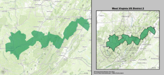
West Virginia's 2nd congressional district stretches from the Ohio River border with Ohio to the Potomac River border with Maryland and the border with Virginia. It includes the capital city of Charleston and the rapidly growing residential communities of West Virginia's Eastern Panhandle and Potomac Highlands regions connected by a narrow strip of nearly unpopulated counties. It has been accurately described as 20 miles wide and 300 miles long.

West Virginia's 1st congressional district is located in the northern part of the state. It is the most regularly drawn of the state's three districts.

State Route 84 is a primary state highway in the U.S. state of Virginia. Known as Mill Gap Road, the state highway runs 14.94 miles (24.04 km) from the West Virginia state line near Mill Gap, where the highway continues west as West Virginia Route 84, east to U.S. Route 220 at Vanderpool.
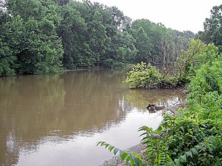
Sandy Creek is a tributary of the Ohio River in western West Virginia in the United States. Via the Ohio River, it is part of the watershed of the Mississippi River, draining an area of 124 square miles (320 km2) on the unglaciated portion of the Allegheny Plateau. The creek is 22 miles (35 km) long, or 38.3 miles (61.6 km) including its Left Fork.

Grays Flat is an unincorporated community in Marion County, West Virginia, United States. It lies along the Paw Paw Creek, adjacent on the northeast of Grant Town.

This is a list of the National Register of Historic Places listings in Marion County, West Virginia.
Logansport is an unincorporated community in Marion County, West Virginia, United States. Logansport is located on Buffalo Creek and County Route 1 3.8 miles (6.1 km) west of Mannington.
Highland is an unincorporated community in Marion County, West Virginia, United States. Highland is located on the West Fork River 1.25 miles (2.01 km) west of Worthington.
Jordan is an unincorporated community in Marion County, West Virginia, United States. Jordan is located along the Monongahela River 5.5 miles (8.9 km) northeast of Fairmont.
Meadowdale, West Virginia may refer to the following communities in West Virginia:
Meadowdale is an unincorporated community in Jackson County, West Virginia, United States. Meadowdale is located on County Route 13 and the Right Fork Sandy Creek 8.1 miles (13.0 km) northeast of Ripley. Meadowdale once had a post office, which is now closed.
Pleasant View is an unincorporated community in Marion County, West Virginia, United States. Pleasant View is located along U.S. Route 19 1.3 miles (2.1 km) north of Rivesville.

Meadowdale is an unincorporated community in Highland County, Virginia, United States. Meadowdale is located 5.2 miles (8.4 km) southwest of Monterey, Virginia on State Route 84.


