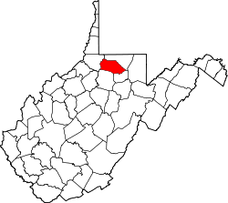
Four States, West Virginia | |
---|---|
Unincorporated community | |
Coordinates: 39°28′47″N80°18′35″W / 39.47972°N 80.30972°W Coordinates: 39°28′47″N80°18′35″W / 39.47972°N 80.30972°W | |
Country | United States |
State | West Virginia |
County | Marion |
Elevation | 1,050 ft (320 m) |
Time zone | Eastern (EST) (UTC-5) |
• Summer (DST) | EDT (UTC-4) |
ZIP code | 26572 |
Area code(s) | 304 & 681 |
GNIS feature ID | 1554500 [1] |
Four States is an unincorporated community in Marion County, West Virginia, United States. Four States is located along a railroad line northwest of Worthington. Four States has a post office with ZIP code 26572. [2]
In law, an unincorporated area is a region of land that is not governed by a local municipal corporation; similarly an unincorporated community is a settlement that is not governed by its own local municipal corporation, but rather is administered as part of larger administrative divisions, such as a township, parish, borough, county, city, canton, state, province or country. Occasionally, municipalities dissolve or disincorporate, which may happen if they become fiscally insolvent, and services become the responsibility of a higher administration. Widespread unincorporated communities and areas are a distinguishing feature of the United States and Canada. In most other countries of the world, there are either no unincorporated areas at all, or these are very rare; typically remote, outlying, sparsely populated or uninhabited areas.
Marion County is a county in the U.S. state of West Virginia. As of the 2010 census, the population was 56,418. Its county seat is Fairmont. The county was named in honor of General Francis Marion, known to history as "The Swamp Fox".
West Virginia is a state located in the Appalachian region in the Southern United States and is also considered to be a part of the Middle Atlantic States. It is bordered by Pennsylvania to the north, Maryland to the east and northeast, Virginia to the southeast, Kentucky to the southwest, and Ohio to the northwest. West Virginia is the 41st largest state by area, and is ranked 38th in population. The capital and largest city is Charleston.
The community was named for the fact the proprietor owned mines in four U.S. states. [3]
In the United States, a state is a constituent political entity, of which there are currently 50. Bound together in a political union, each state holds governmental jurisdiction over a separate and defined geographic territory and shares its sovereignty with the federal government. Due to this shared sovereignty, Americans are citizens both of the federal republic and of the state in which they reside. State citizenship and residency are flexible, and no government approval is required to move between states, except for persons restricted by certain types of court orders. Four states use the term commonwealth rather than state in their full official names.
Asbury is an unincorporated community in Greenbrier County, West Virginia, United States. Asbury is located on West Virginia Route 12 northeast of Alderson. Asbury has a post office with ZIP code 24916.
Charmco is an unincorporated community and coal town in Greenbrier County, West Virginia, United States. Charmco is located at the junction of U.S. Route 60 and West Virginia Route 20 northeast of Rainelle. Charmco has a post office with ZIP code 25958. The community was named for the Charleston Milling Company.
Squire is an unincorporated community in McDowell County, West Virginia, United States. Squire is located on West Virginia Route 16 6.5 miles (10.5 km) southeast of War. Squire has a post office with ZIP code 24884.
Romance is an unincorporated community in Jackson County, West Virginia, United States. It used to have a post office with a zip code of 25175, but it closed on February 18, 1986. The area between Middle Fork and Advent is also considered Romance.
Nallen is an unincorporated community in Fayette and Nicholas counties, West Virginia, United States. Nallen is located along West Virginia Route 41 12 miles (19 km) south of Summersville. Nallen has a post office with ZIP code 26680.
Spring Dale is an unincorporated community in Fayette County, West Virginia, United States. Spring Dale is located on West Virginia Route 20 3 miles (4.8 km) northeast of Meadow Bridge. Spring Dale has a post office with ZIP code 25986.
Lookout is an unincorporated community in Fayette County, West Virginia, United States. Lookout is located on U.S. Route 60 7.5 miles (12.1 km) east of Fayetteville. Lookout has a post office with ZIP code 25868.
Lochgelly, originally named Stewart, is an unincorporated community in Fayette County, West Virginia, United States. Lochgelly is 2.5 miles (4.0 km) north of Oak Hill. Lochgelly has a post office with ZIP code 25866.
Lanark is an unincorporated community in Raleigh County, West Virginia, United States. Lanark is located on West Virginia Route 41 4 miles (6.4 km) northeast of downtown Beckley. Lanark has a post office with ZIP code 25860.
Dothan is an unincorporated community in Fayette County, West Virginia, United States. Dothan is located on West Virginia Route 612 4 miles (6.4 km) west of Oak Hill. Dothan had a post office, which closed on October 5, 1991.
Danese is an unincorporated community in Fayette County, West Virginia, United States. Danese is located on West Virginia Route 41 5.5 miles (8.9 km) northwest of Meadow Bridge. Danese has a post office with ZIP code 25831.
Layland is an unincorporated community in Fayette County, West Virginia, United States. Layland is located on West Virginia Route 41 6.5 miles (10.5 km) west-northwest of Meadow Bridge. Layland has a post office with ZIP code 25864.
Skelton is an unincorporated community in Raleigh County, West Virginia, United States. Skelton is located on U.S. Route 19 2 miles (3.2 km) north of downtown Beckley. Skelton has a post office with ZIP code 25919.
Sprague is an unincorporated community and coal town in Raleigh County, West Virginia, United States. Sprague is located on West Virginia Route 16 1 mile (1.6 km) north of downtown Beckley. Sprague has a post office with ZIP code 25926.
Surveyor is an unincorporated community in Raleigh County, West Virginia, United States. Surveyor is located on West Virginia Route 305 7 miles (11 km) west of Beckley. Surveyor has a post office with ZIP code 25932.
Naoma is an unincorporated community in Raleigh County, West Virginia, United States. Naoma is located on West Virginia Route 3 7.5 miles (12.1 km) south-southeast of Whitesville. Naoma has a post office with ZIP code 25140.
Miami is an unincorporated community in Kanawha County, West Virginia, United States. Miami is 4.5 miles (7.2 km) south of East Bank along Cabin Creek. Miami has a post office with ZIP code 25134.
Tad is an unincorporated community in Kanawha County, West Virginia, United States. Tad is 7.5 miles (12.1 km) east of Charleston. Tad has a post office with ZIP code 25201.
Pond Gap is an unincorporated community in Kanawha County, West Virginia, United States. Pond Gap is 7 miles (11 km) north-northeast of Smithers. Pond Gap has a post office with ZIP code 25160.
Colcord is an unincorporated community in Raleigh County, West Virginia, United States. Colcord is 5.5 miles (8.9 km) east-southeast of Whitesville. Colcord had a post office, which closed on November 30, 2002. The community was named after the proprietor of the Colcord Coal Company.
This article about a location in Marion County, West Virginia is a stub. You can help Wikipedia by expanding it. |