Shepherdstown, West Virginia

Last updated

Shepherdstown, West Virginia
German Street Shepherdstown WV4.jpg
Jefferson County West Virginia Incorporated and Unincorporated areas Shepherdstown Highlighted.svg
Location of Shepherdstown in Jefferson County, West Virginia.
Coordinates: 39°25′55″N77°48′17″W / 39.43194°N 77.80472°W / 39.43194; -77.80472
CountryUnited States
State West Virginia
County Jefferson
Settlement1730
EstablishedDecember 23, 1762
Area
[1]
  Total0.401 sq mi (1.039 km2)
  Land0.401 sq mi (1.039 km2)
  Water0.000 sq mi (0.000 km2)
Elevation
[2]
400 ft (100 m)
Population
 (2020) [3]
  Total1,531
  Estimate 
(2021) [4]
1,494
  Density4,765.59/sq mi (1,838.73/km2)
Time zone UTC-5 (EST)
  Summer (DST) UTC-4 (EDT)
ZIP code
25443
Area code 304
FIPS code 54-73468
GNIS feature ID2391411 [2]
Website www.shepherdstown.us

Shepherdstown is a town in Jefferson County, West Virginia, United States, located in the lower Shenandoah Valley along the Potomac River. Home to Shepherd University, the town's population was 1,531 at the time of the 2020 census. [3] The town was established in 1762 along with Romney; they are the oldest towns in West Virginia.

Contents

History

18th century

Established on December 23, 1762, by consecutive acts passed by the Virginia House of Burgesses and approved by the governor, Mecklenburg (later renamed Shepherdstown), and Romney in Hampshire County are the oldest towns in West Virginia. [5] On a list of more than 30 approved "publick and private bills" of that date, the bill containing An Act for establishing the town of Mecklenburg, in the county of Frederick immediately follows An act for establishing the town of Romney, in the county of Hampshire, and for other purposes therein-mentioned. [6]

The first British colonial settlers began their migration into the northern end of the Shenandoah Valley in the early 18th century. Many crossed the Potowmack (now Potomac) River at Pack Horse Ford, about one mile (1.6 km) down river from the future site of Shepherdstown. The Colony of Virginia began issuing Valley land grants in the 1730s. In 1734, Thomas Shepherd (1705–1776) was granted 222 acres (90 ha) on the south side of the Potomac, along the Falling Spring Branch (now known as the Town Run). From that tract he selected 50 acres (20 ha) and laid out a town. Naming his town Mecklenburg, he petitioned the Virginia General Assembly for a charter, which was granted in 1762.

Shepherd was the sole trustee, owning the town and being responsible for its government. More than six natural springs feed Town Run before it enters the south end of town. It never floods, nor runs dry; it meanders through backyards, under houses, across alleys and beneath five streets. This setting was conducive to millers, tanners, potters, smiths and other artisans. As a result, by 1775, the town boasted 1,000 inhabitants. In 1775, General George Washington issued a call for "Virginia Volunteer Riflemen." Captain Hugh Stephenson filled the ranks of his company here. The troops departed from "Morgan's Spring," about one-half mile (0.80 km) south of the town limits, on July 16, 1775. This famous "Beeline March to Cambridge" covered 600 mi (970 km) in 24 days. Thirty-eight Revolutionary veterans are buried in the surrounding area.

On December 3, 1787, James Rumsey conducted a successful trial of his new invention, the steamboat, in the Potomac at the north end of Princess Street. The first newspaper—The Potomac Guardian and Berkley Advertiser—and book (The Christian Panoply) in what is now West Virginia were published here (1790s). (The Shepherdstown Public Library has a copy of the book.) Shepherdstown was the birthplace of Robert Lucas (1781), the future governor of Ohio and territorial governor of Iowa.

A second charter, which allowed for self-government, was granted by the Commonwealth of Virginia in 1794. In 1798, the corporate limits were extended and the name was changed to Shepherd's Town. After the American Civil War, the town's name was officially contracted to Shepherdstown. The clay soil in the area was conducive to brick making. By the late 1790s, there were several commercial brickyards, and kilns could be built with little difficulty. In many instances, bricks were "burnt" at the construction sites. They were plentiful and cheaper than nails. Roofing material affected the market value and the insurance premiums of the brick structures. Those covered with tile were much more valuable than those topped with wooden shingles. Fires starting in the shingles destroyed many brick homes, mills, stores and outbuildings.

19th century

Lock 38 of the Chesapeake and Ohio Canal and ruins of a bridge across the Potomac River, ca. 1861-1865 Ca-1861-1865-bridge-ruins-C&O-Canal-Lock-38-Potomac-Shepherdstown.tif
Lock 38 of the Chesapeake and Ohio Canal and ruins of a bridge across the Potomac River, ca. 1861–1865

Running along the Maryland side of the Potomac River, the Chesapeake and Ohio (C&O) Canal reached Shepherdstown in the early 1830s. Lock no. 38—named "Shepherdstown River Lock"—was built across from Shepherdstown at mile 72.7 of the canal. One of only three of its kind on the canal, it allowed canal boats to transfer between the canal and the river to serve industries in Shepherdstown with shipments of cement, coal, flour, corn, wheat, oats, flour, and timothy seed. [7] Shepherdstown is the only town in West Virginia that has a canal lock named for it.

Two free schools were built in the town in 1848. One still stands on the southeast corner of Princess and New Streets. When West Virginia became the 35th state (in 1863), these became the oldest free schoolhouses in the state.

The Hamtramck Guard (The Shepherdstown Light Infantry) was dispatched to nearby Harpers Ferry to subdue John Brown's raid on the federal armory (October 1859). At the outbreak of the Civil War, this group became Company B, 2nd Virginia Infantry, Army of Northern Virginia. They became part of the famous "Stonewall Brigade."

After the nearby Battle of Antietam in Maryland, September 17, 1862, General Robert E. Lee's infantry crossed the Potomac at Pack Horse Ford. The town was overwhelmed with 5,000–8,000 casualties from the battle. Every house, building, church, alley, and street was filled with the wounded and dying. The Battle of Shepherdstown (also known as the Battle of Boteler's Ford or Cement Mill) occurred on September 20, 1862, during Lee's retreat. More than 100 Confederate soldiers died here and were buried in Elmwood Cemetery. Elmwood contains the graves of 285 Confederate veterans.

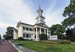
From 1865 to 1871, Shepherdstown served as the county seat of Jefferson County due to war damage to the courthouse in Charles Town. The Town Hall (northeast corner of German and King streets) housed the courthouse until it was moved back to Charles Town.

In 1872, the Town Hall Building was chartered as a "Classical and Scientific Institute." The building was then leased to the state and Shepherd College was born. In 2004, the Shepherd College became Shepherd University. The East Campus occupies about one-third of the town proper, and the West Campus occupies a large area just northwest of the corporate limits.

20th century to present

McMurran Hall, Shepherd University McMurran Hall WV2.jpg
McMurran Hall, Shepherd University

The Shepherdstown Historic District was established and added to the National Register of Historic Places in 1973, with a boundary expansion to include the entire town in 1987. Potomac Mills located nearby in Washington County, Maryland, was added in 2014. [8]

On January 3, 2000, Shepherdstown was the site of the Peace Talks between Israel and Syria. [9] [10]

In 2012, the town celebrated its 250th anniversary. Billed as the most haunted town in America, Shepherdstown is known as much for its ghostly residents as it is for the local arts scene, university, and historic attractions. [11] On June 12, 2016, Destination America’s premiered the paranormal show Ghosts of Shepherdstown, starring Nick Groff, Elizabeth Saint, and Bill Hartley.

Geography

Shepherdstown is located in the upper Shenandoah Valley along the Potomac River in the Eastern Panhandle of West Virginia.

According to the United States Census Bureau, the town has a total area of 0.37 square miles (0.96 km2), all land. [12]

Bedrock exposures of Cambrian-aged Conococheague limestone and dolomite are frequent in the town, and form cliffs between the settled area and the Potomac River.

Demographics

Historical population
CensusPop.Note
1850 1,561
1860 1,219−21.9%
1870 1,38913.9%
1880 1,53310.4%
1890 1,515−1.2%
1900 1,184−21.8%
1910 1,070−9.6%
1920 1,063−0.7%
1930 888−16.5%
1940 9456.4%
1950 1,17324.1%
1960 1,32813.2%
1970 1,68827.1%
1980 1,7916.1%
1990 1,287−28.1%
2000 803−37.6%
2010 1,734115.9%
2020 1,531−11.7%
2021 (est.)1,494 [4] −2.4%
U.S. Decennial Census [13]
2020 Census [3]

2010 census

As of the census of 2010, there were 1,734 people, 518 households, and 192 families living in the town. The population density was 4,686.5 inhabitants per square mile (1,809.5/km2). There were 583 housing units at an average density of 1,575.7 per square mile (608.4/km2). The racial makeup of the town was 85.5% White, 9.5% African American, 0.1% Native American, 1.3% Asian, 0.1% Pacific Islander, 1.0% from other races, and 2.5% from two or more races. Hispanic or Latino of any race were 2.9% of the population.

There were 518 households, of which 15.6% had children under the age of 18 living with them, 24.5% were married couples living together, 9.5% had a female householder with no husband present, 3.1% had a male householder with no wife present, and 62.9% were non-families. 33.2% of all households were made up of individuals, and 9.8% had someone living alone who was 65 years of age or older. The average household size was 2.15 and the average family size was 2.79.

The median age in the town was 21.9 years. 7.6% of residents were under the age of 18; 55.7% were between the ages of 18 and 24; 15% were from 25 to 44; 14.1% were from 45 to 64; and 7.6% were 65 years of age or older. The gender makeup of the town was 46.5% male and 53.5% female.

2000 census

As of the census of 2000, there were 803 people, 410 households, and 168 families living in the town. The population density was 2,217.7 inhabitants per square mile (856.3/km2). There were 454 housing units at an average density of 1,253.8 per square mile (484.1/km2). The racial makeup of the town was 80.20% White, 17.19% African American, 0.50% Native American, 0.87% Asian, 0.12% Pacific Islander, and 1.12% from two or more races. Hispanic or Latino of any race were 0.87% of the population.

There were 410 households, out of which 13.9% had children under the age of 18 living with them, 28.8% were married couples living together, 9.8% had a female householder with no husband present, and 58.8% were non-families. 41.5% of all households were made up of individuals, and 12.7% had someone living alone who was 65 years of age or older. The average household size was 1.96 and the average family size was 2.72.

In the town, the population was spread out, with 12.5% under the age of 18, 19.9% from 18 to 24, 25.7% from 25 to 44, 25.9% from 45 to 64, and 16.1% who were 65 years of age or older. The median age was 40 years. For every 100 females, there were 100.8 males. For every 100 females age 18 and over, there were 95.3 males.

The median income for a household in the town was $40,750, and the median income for a family was $55,000. Males had a median income of $35,833 versus $30,139 for females. The per capita income for the town was $28,539. About 7.5% of families and 15.3% of the population were below the poverty line, including 8.1% of those under age 18 and 1.5% of those age 65 or over.

Culture

Many of the town's historical buildings on German Street are now home to shops and cafés. The town is also home to many local artistic and theatrical groups, many of which are affiliated with Shepherd University or operated by youth groups. Shepherdstown also supports several restaurants and music venues. Monthly contra dances are sponsored by Shepherdstown Music and Dance.

Shepherdstown is also home to the first cohousing community in West Virginia, the Shepherd Village. The Shepherd Village was established in 2013 and now has 30 member households.

Historic sites

SiteYear BuiltAddressListed
Boidstones Place (Greenbrakes Farm)Shepherd Grade1999
Cold Spring 1793CR 171973
Elmwood 1797CR 171973
Falling Spring-Morgan's Grove WV 480 1989
Fruit Hill (Robinson-Andrews-Hoxton House)Shepherd Grade1988
Captain William Lucas and Robert Lucas House (Linden Spring)1793CR 311982
James Marshall House (Marshall Hall)Shepherd Grade1988
Morgan's Grove WV 480, WV 230, Morgan's Grove Road1999
Morgan-Bedinger-Dandridge House (Rosebrake) WV 480 1983
Rockland 1897 WV 480 1990
Rose Hill Farm (James-Marshall-Snyder Farm)Off WV 480 1990
Rumsey Hall (Entler Hotel)late 18th centuryGerman & Princess Streets1973
Shepherd's Mill (Thomas Shepherd's Grist Mill)High Street1971
Van Swearingen-Shepherd House (Bellevue)Shepherd Grade1983

Transportation

WV 45 westbound heading out of Shepherdstown 2016-09-27 10 24 16 View west along West Virginia State Route 45 (Martinsburg Pike) at University Drive in Shepherdstown, Jefferson County, West Virginia.jpg
WV 45 westbound heading out of Shepherdstown

Three primary highways serve Shepherdstown. West Virginia Route 45 heads west from Shepherdstown to Martinsburg and Interstate 81. West Virginia Route 230 extends southward to U.S. Route 340 near Harpers Ferry. Finally, West Virginia Route 480 extends east to cross the Potomac River into Maryland, continuing as Maryland Route 34 towards Sharpsburg. Westward, WV 480 connects to West Virginia Route 9.

Notable people

Related Research Articles

<span class="mw-page-title-main">Harpers Ferry, West Virginia</span> Town in West Virginia, United States

Harpers Ferry is a historic town in Jefferson County, West Virginia, United States, in the lower Shenandoah Valley. The population was 285 at the 2020 census. Situated at the confluence of the Potomac and Shenandoah rivers, where the U.S. states of Maryland, Virginia, and West Virginia meet, it is the easternmost town in West Virginia.

<span class="mw-page-title-main">Jefferson County, West Virginia</span> County in West Virginia, United States

Jefferson County is located in the Shenandoah Valley in the Eastern Panhandle of West Virginia. It is the easternmost county of the U.S. state of West Virginia. As of the 2020 census, the population was 57,701. Its county seat is Charles Town. The county was founded in 1801, and today is part of the Washington metropolitan area.

<span class="mw-page-title-main">Hardy County, West Virginia</span> County in West Virginia, United States

Hardy County is a county in the U.S. state of West Virginia. As of the 2020 census, the population was 14,299. Its county seat is Moorefield. The county was created from Hampshire County in 1786 and named for Samuel Hardy, a distinguished Virginian.

<span class="mw-page-title-main">Westernport, Maryland</span> Town in Maryland, United States

Westernport is a town in Allegany County, Maryland, United States, along the Georges Creek Valley. It is part of the Cumberland, MD-WV Metropolitan Statistical Area. The population was 1,888 at the 2010 census.

<span class="mw-page-title-main">Brunswick, Maryland</span> City in Maryland

Brunswick is a city in southwestern Frederick County, Maryland, United States. The city is located on the north bank of the Potomac River; Loudoun County, Virginia occupies the opposite shore. The population of Brunswick was 8,211 at the 2022 Census. There are three schools serving Brunswick: Brunswick Elementary School, Brunswick Middle School, and Brunswick High School.

<span class="mw-page-title-main">Cabin John, Maryland</span> Census-designated place in Maryland, United States

Cabin John is a census-designated place and unincorporated area in Montgomery County, Maryland, United States. As of the 2020 census, it had a population of 2,459. Overlooking the Potomac River, it is a suburb of Washington, D.C.

<span class="mw-page-title-main">Sharpsburg, Maryland</span> Town in Maryland, United States

Sharpsburg is a town in Washington County, Maryland. The town is approximately 13 miles (21 km) south of Hagerstown. Its population was 560 at the 2020 census.

<span class="mw-page-title-main">Williamsport, Maryland</span> Town in Maryland, United States

Williamsport is a town in Washington County, Maryland, United States. The population was 1,868 at the 2000 census and 2,137 as of 2010.

<span class="mw-page-title-main">Great Falls, Virginia</span> Census-designated place in Virginia, United States

Great Falls is a census-designated place in Fairfax County, Virginia, United States. The population at the 2020 census was 15,953.

<span class="mw-page-title-main">Mount Vernon, Virginia</span> Census-designated place in Virginia, United States

Mount Vernon is a census-designated place (CDP) and unincorporated community in Fairfax County, Virginia, United States. The population was 12,914 at the 2020 census. Primarily due to its historical significance and natural recreation and beauty, the Mount Vernon area receives over one million tourists each year.

<span class="mw-page-title-main">Round Hill, Loudoun County, Virginia</span> Town in Virginia

Round Hill is a town in Loudoun County, Virginia, United States. Its population was 693 at the 2020 census. The town is located at the crossroads of Virginia Routes 7 and 719, approximately 50 miles (80 km) northwest of Washington, D.C. The town's name refers a hill two miles northeast of a 910-foot (280 m) hill used during the American Civil War as a signal post by both Confederate and Union troops. House of Round Hill was built in 2004. Patsy Cline went to Round Hill Elementary School.

<span class="mw-page-title-main">Falmouth, Virginia</span> Census-designated place in Virginia, United States

Falmouth is a census-designated place (CDP) in Stafford County, Virginia, United States. Situated on the north bank of the Rappahannock River at the falls, the community is north of and opposite the city of Fredericksburg. Recognized by the U.S. Census Bureau as a census-designated place (CDP), Falmouth's population was 4,956 as of the 2020 census.

<span class="mw-page-title-main">Colonial Beach, Virginia</span> Town in Virginia, United States

Colonial Beach, Virginia (CBVA) is a river and beach town located in the northwestern part of Westmoreland County on Virginia's Northern Neck peninsula. It is bounded by the Potomac River, Monroe Bay and Monroe Creek. It is located 65 mi (105 km) from Washington, D.C.; 70 mi (110 km) from the state capital of Richmond; and 35 nautical miles from the Chesapeake Bay.

<span class="mw-page-title-main">Romney, West Virginia</span> Town in West Virginia, United States

Romney is a town in and the county seat of Hampshire County, West Virginia, United States. The population was 1,722 at the 2020 census. It is part of the Winchester, Virginia metropolitan area. The town was established in 1762 along with Shepherdstown; together, they are the two oldest towns in West Virginia.

<span class="mw-page-title-main">Moorefield, West Virginia</span> Town in West Virginia, United States

Moorefield is a town and the county seat of Hardy County, West Virginia, United States. It is located at the confluence of the South Branch Potomac River and the South Fork South Branch Potomac River. Moorefield was originally chartered in 1777; it was named for Conrad Moore, who owned the land upon which the town was laid out. The population was 2,527 at the 2020 census.

<span class="mw-page-title-main">Bolivar, West Virginia</span> Town in West Virginia, United States

Bolivar is a town in Jefferson County, West Virginia, United States. The population was 1,072 at the 2020 census. The town is named for South American revolutionary leader Simón Bolívar. Located in West Virginia's Eastern Panhandle, it is part of the northwestern fringes of the Washington metropolitan area.

<span class="mw-page-title-main">Keyser, West Virginia</span> City in West Virginia, United States

Keyser is a city in and the county seat of Mineral County, West Virginia. It is part of the Cumberland, MD-WV Metropolitan Statistical Area. The population was 4,853 at the 2020 census.

<span class="mw-page-title-main">Piedmont, West Virginia</span> Town in West Virginia, United States

Piedmont is a town in Mineral County, West Virginia, United States. It is part of the Cumberland, MD-WV metropolitan statistical area. The population was 716 at the 2020 census. Piedmont was chartered in 1856 and the town is the subject of Colored People: A Memoir by Piedmont native Henry Louis Gates Jr.

<span class="mw-page-title-main">Berkeley Springs, West Virginia</span> Town in West Virginia, United States

Berkeley Springs is a town in, and the county seat of, Morgan County, West Virginia, United States, in the state's Eastern Panhandle. Berkeley Springs is also commonly used to refer to the area in and around the Town of Bath. In 1776, the Virginia Legislature incorporated a town around the springs and named it Bath. Since 1802, it has been referred to by the name of its original post office, Berkeley Springs. The population was 758 at the 2020 census. It is part of the Hagerstown–Martinsburg metropolitan area.

<span class="mw-page-title-main">Paw Paw, West Virginia</span> Town in West Virginia, United States

Paw Paw is a town in Morgan County, West Virginia, United States. The population was 410 at the 2020 census. The town is known for the nearby Paw Paw Tunnel. Paw Paw was incorporated by the Circuit Court of Morgan County on April 8, 1891, and named after pawpaw, a wild fruit that grows in abundance throughout this region. Paw Paw is the westernmost incorporated community in Morgan County, and the Hagerstown-Martinsburg, MD-WV Metropolitan Statistical Area.

References

  1. "2021 U.S. Gazetteer Files". United States Census Bureau. Retrieved February 25, 2023.
  2. 1 2 U.S. Geological Survey Geographic Names Information System: Shepherdstown, West Virginia
  3. 1 2 3 "Explore Census Data". United States Census Bureau . Retrieved February 25, 2023.
  4. 1 2 "City and Town Population Totals: 2020-2021". United States Census Bureau. February 25, 2023. Retrieved February 25, 2023.
  5. "An Act for establishing the town of Mecklenburg, in the county of Frederick, Hening's Statutes at Large, Vol. VII, Chapter XXII". vagenweb.org. Retrieved March 5, 2017.
  6. Burgesses, Virginia General Assembly House of (January 1, 1907). Journals of the House of Burgesses of Virginia, 1761-1765. Colonial Press, E. Waddey Company. pp. 164–165.
  7. C&O Canal Explorer. C&O Canal Trust.
  8. "Weekly List of Actions Taken on Properties: 2/03/14 Through 2/07/14". National Park Service . Retrieved February 27, 2014.
  9. Reinckens, William B. (January 3, 2000). "Israel and Syria Open Peace Talks in Shepherdstown, West Virginia". Washington File. United States Department of State. Archived from the original on November 7, 2004. Retrieved April 3, 2015.
  10. Kilian, Michael. "MOMENTOUS TALKS IN A QUIET TOWN". chicagotribune.com. Retrieved March 26, 2021.
  11. "DESTINATION AMERICA STEPS INTO THE DARKEST TOWN IN AMERICA IN THE ALL-NEW SERIES GHOSTS OF SHEPHERDSTOWN : Discovery Press Web". Discovery Press Web. Retrieved May 27, 2016.
  12. "US Gazetteer files 2010". United States Census Bureau. Archived from the original on January 12, 2012. Retrieved January 24, 2013.
  13. United States Census Bureau. "Census of Population and Housing" . Retrieved August 27, 2013.
  14. Who Was Who in America, Historical Volume, 1607–1896. Chicago: Marquis Who's Who. 1963.
  15. Flora, Joseph M.; Vogel, Amber (June 21, 2006). Southern Writers: A New Biographical Dictionary. LSU Press. p. 94. ISBN   978-0-8071-3123-7.
  16. Harmon, Elizabeth (August 4, 2020). "Serena Katherine "Violet" Dandridge: Suffragist and Scientific Illustrator". Smithsonian Institution Archives. Retrieved April 13, 2022.