
Jefferson County is located in the Shenandoah Valley in the Eastern Panhandle of West Virginia. It is the easternmost county of the U.S. state of West Virginia. As of the 2020 census, the population was 57,701. Its county seat is Charles Town. The county was founded in 1801, and today is part of the Washington metropolitan area.

Boyce is a small incorporated town in Clarke County, Virginia, United States. The population was 749 at the 2020 census, up from 589 at the 2010 census.
Round Hill is a town in Loudoun County, Virginia, United States. Its population was 539 at the 2010 census and an estimated 656 in 2019. The town is located at the crossroads of Virginia Routes 7 and 719, approximately 50 miles (80 km) northwest of Washington, D.C. The town's name refers a hill two miles northeast of a 910-foot (280 m) hill used during the American Civil War as a signal post by both Confederate and Union troops. House of Round Hill was built in 2004. Patsy Cline went to Round Hill Elementary School.

U.S. Route 340 is a spur route of US 40, and runs from Greenville, Virginia, to Frederick, Maryland. In Virginia, it runs north–south, parallel and east of US 11, from US 11 north of Greenville via Waynesboro, Grottoes, Elkton, Luray, Front Royal, and Berryville to the West Virginia state line. A short separate piece crosses northern Loudoun County on its way from West Virginia to Maryland.

The Second Battle of Winchester was fought between June 13 and June 15, 1863, in Frederick County and Winchester, Virginia as part of the Gettysburg Campaign during the American Civil War. As Confederate Lieutenant General Richard S. Ewell moved north through the Shenandoah Valley in the direction of Pennsylvania, his corps defeated the Union Army garrison commanded by Major General Robert H. Milroy, capturing Winchester and numerous Union prisoners.

John Daniel Imboden, American lawyer, Virginia state legislator, and a Confederate army general. During the American Civil War, he commanded an irregular cavalry force. After the war, he resumed practicing law, became a writer, and was active in land development founding the town of Damascus, Virginia.
The town of Romney, Virginia, traded hands between the Union Army and Confederate States Army no fewer than 10 times during the American Civil War, assuming the occupying force spent at least one night in the town. The story of the small town is emblematic of the many military campaigns that swept through western Virginia and, later, the new state of West Virginia.

Rippon Lodge is one of the oldest houses remaining in Prince William County, Virginia, and listed on the National Register of Historic Places since 1971. Built around 1747 by Richard Blackburn (1705-1757) as the main residence and headquarters of his plantation, it lies on high ground overlooking Neabsco Creek at the south end of what is now the unincorporated town of Woodbridge at 15520 Blackburn Road. The house takes its name from Richard Blackburn's birthplace, the small city of Ripon in North Yorkshire, England.
Loudoun County, Virginia, was destined to be an area of significant military activity during the American Civil War. Located on Virginia's northern frontier, the Potomac River, Loudoun County became a borderland after Virginia's secession from the Union in early 1861. Loudoun County's numerous Potomac bridges, ferries and fords made it an ideal location for the Union and Confederate armies to cross into and out of Virginia. Likewise, the county's several gaps in the Blue Ridge Mountains that connected the Piedmont to the Shenandoah Valley and Winchester were of considerable strategic importance. The opposing armies would traverse the county several times throughout the war leading to several small battles, most notably the Battle of Ball's Bluff.

White Post is an unincorporated community in Clarke County, Virginia. White Post is located at the crossroads of White Post Road and Berrys Ferry Road off Lord Fairfax Highway.
Heaton's Crossroads, also known as the Purcellville Wagon Raid, was an American Civil War skirmish that took place between Federal cavalry under Brig. Gen. Alfred N. Duffié and Confederate infantry under Maj. Gen. John C. Breckinridge on July 16, 1864, near present-day Purcellville, Virginia in Loudoun County as part of the Valley Campaigns of 1864. The action was tactically inconclusive.
The Battle of Charlestown was a small engagement between Confederate cavalry forces under Brig. Gen. John D. Imboden and the Union forces under Col. Benjamin L. Simpson on October 18, 1863, at Charles Town, West Virginia, as part of the Bristoe and Mine Run Campaigns, resulting in a Confederate victory.
Fort Evans is a Civil War-era rectangular earthen fort located in Leesburg, Virginia. It was the first of three forts constructed in 1861 to protect Leesburg from possible invasion after Virginia seceded from the Union.
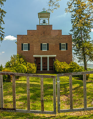
Ripon Lodge, located near the village of Rippon, West Virginia, was built in 1833 by Henry S. Turner on his "Wheatland" estate. The next year his son, William F. Turner, inherited Ripon Lodge. The house is a two-story T-shaped stone building with a detached 1+1⁄2-story stone summer kitchen. The interior contains an elegant half-spiral curving stairway to the second floor.

Beverley, also known as Bullskin, is a farm near Charles Town, West Virginia that has been a working agricultural unit since 1750. The narrow lane that leads from U.S. Route 340 to the Beverley complex was, in the 18th and 19th centuries a toll road. The main house was built about 1800 by Beverley Whiting on the site of a c. 1760 stone house. The house is Georgian influenced Federal style, with a later Greek Revival portico. A number of outbuildings dating to the original 1760 house accompany the main house.
The Affair at Glenmore Farm was a small cavalry skirmish that took place October 16, 1862 in Loudoun County, Virginia between Confederate forces under First Lieutenant Frank Myers and Union forces under General John Geary during the American Civil War. The skirmish resulted in a Union victory.
The Jones–Imboden Raid was a Confederate military action conducted in western Virginia in April and May 1863 during the American Civil War. The raid, led by Brig. Gens. William E. Jones and John D. Imboden, was aimed at disrupting traffic on the vital Baltimore and Ohio Railroad and reasserting Confederate authority in transmountain Virginia in an effort to derail the growing statehood movement in the region, since voters had in March approved a new Constitution and statehood only awaited Congressional and Presidential approval.
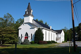
Wickliffe Church is a historic Episcopal church building located in Berryville, Clarke County, Virginia. The church has not been in active use since 1918, except for an annual homecoming service held in August and occasional special events.


