Related Research Articles

Bullskin Township is a township in Fayette County, Pennsylvania, United States. The population was 6,741 at the 2020 census, a decline from the figure of 6,966 tabulated in 2010. It is served by the Connellsville Area School District.
Back Creek is a 59.5-mile-long (95.8 km) tributary of the Potomac River that flows north from Frederick County, Virginia, to Berkeley County in West Virginia's Eastern Panhandle. Back Creek originates along Frederick County's border with Hampshire County, West Virginia, at Farmer's Gap in the Great North Mountain. Its name reflects its location to the west of North Mountain. The perspective of colonists from the east in the 18th century led them to call it "Back Creek", because it lay to the back of North Mountain.

Dillons Run is a 12.9-mile-long (20.8 km) tributary stream of the Cacapon River, belonging to the Potomac River and Chesapeake Bay watersheds. The stream is located in Hampshire County in the U.S. state of West Virginia's Eastern Panhandle.

Edwards Run is a 7.9-mile-long (12.7 km) tributary stream of the Cacapon River, belonging to the Potomac River and Chesapeake Bay watersheds. The stream is located in Hampshire County in the U.S. state of West Virginia's Eastern Panhandle. Edwards Run is named for Joseph Edwards and his family, whose plantation encompassed most of the stream's course. George Washington surveyed his property in the late 1740s. It is a major source of various species of elodea.
Mill Creek is a 14.5-mile-long (23.3 km) tributary of Opequon Creek, belonging to the Potomac River and Chesapeake Bay watersheds, located in Berkeley County in West Virginia's Eastern Panhandle. Its name reflects its past as a popular site for various types of mills, beginning with one constructed by Morgan Morgan in the mid-18th century near his cabin in present-day Bunker Hill.
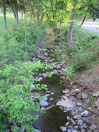
Kabletown is an unincorporated community in Jefferson County, West Virginia, United States. The town lies along a spring-fed stream called Bullskin Run near the Shenandoah River on Kabletown Road, very close to the border with Virginia. Kabletown's population was 10,073 in 2000.
Green Spring Run is an 8.9-mile-long (14.3 km) tributary stream of the North Branch Potomac River in Hampshire County in the U.S. state of West Virginia. Green Spring Run rises in Greenwood Hollow north of Springfield and meanders northeast through Green Spring Valley. The South Branch Valley Railroad and Green Spring Road run parallel to the stream. It runs through the community of Green Spring, from which the stream takes its name. From Green Spring, Green Spring Run flows east where it reaches its confluence with the North Branch Potomac shortly before the North Branch joins with the South Branch Potomac River to form the Potomac River.

Tuscarora Creek in Berkeley County, West Virginia, is an 11.4-mile-long (18.3 km) tributary of Opequon Creek, which drains into the Potomac River in the Chesapeake Bay watershed.
Big Run is a 4.4-mile-long (7.1 km) tributary stream of the South Branch Potomac River, belonging to the Potomac River and Chesapeake Bay watersheds. Big Run flows through the city of Romney and the campus of the West Virginia Schools for the Deaf and Blind in Hampshire County, West Virginia. The stream is known by local residents as Town Run and Town Creek.
Sir Johns Run is an 8.9-mile-long (14.3 km) tributary stream of the Potomac River in Morgan County, West Virginia. For most of its course, Sir Johns Run is a shallow non-navigable stream. It rises on the eastern flanks of Cacapon Mountain and from its source, flows north with Cacapon Mountain to its west and Warm Spring Ridge to its east. During its flow northward through the valley, Sir Johns Run is joined by a number of smaller spring-fed streams. Sir Johns Run empties into the Potomac River at the small community of the same name, Sir Johns Run. The stream takes its name from Sir John St. Clair, a deputy quartermaster present during General Edward Braddock's expedition through the area during the French and Indian War.
Trout Run is an 18.5-mile-long (29.8 km) tributary of the Cacapon River, belonging to the Potomac River and Chesapeake Bay watersheds. The stream is located in Hardy County in West Virginia's Eastern Panhandle. Trout Run rises between Devils Hole Mountain and Great North Mountain near the Virginia state line in the George Washington National Forest. The stream empties into the Cacapon River at Wardensville.
Broad Run is a tributary stream of the Potomac River in Montgomery County, Maryland. The headwaters of the stream originate west of the town of Poolesville, and the creek flows southward for 8.9 miles (14.3 km) to the Potomac River. The Broad Run and its watershed are almost entirely within the Montgomery County Agricultural Reserve.

Naptha is an unincorporated community located in Brunswick County, in the U.S. state of Virginia.
Mill Run is a 9.1-mile-long (14.6 km) tributary stream of the South Branch Potomac River, belonging to the Potomac River and Chesapeake Bay watersheds. The stream is located in Hampshire County in the Eastern Panhandle of the U.S. state of West Virginia. Mill Run rises on Nathaniel Mountain and flows northeast, then northwest into the South Branch south of Romney near Hampshire Park on South Branch River Road.
Camp Hill is a summit in Harpers Ferry, West Virginia, in the United States. With an elevation of 538 feet (164 m), Camp Hill is the 952nd highest summit in the state of West Virginia.
Foltz is an extinct town in Berkeley County, in the U.S. state of West Virginia.
Skinners Gap is a mountain pass in the U.S. state of West Virginia.
Cedar Creek is a stream in Boone and Callaway counties of the U.S. state of Missouri. It is a tributary of the Missouri River. The headwaters of Cedar Creek are in northeast Boone County about five miles east of Hallsville and one mile west of the Audrain-Boone county line. The stream flows south and about five miles south of its headwaters the stream becomes the boundary between Boone and Callaway counties. The stream crosses under Interstate 70 about eight miles east of Columbia and enters the Mark Twain National Forest. The stream flows south to southwest through the national forest and upon leaving the forest turns to the east and ceases to be the county line. The stream flows east for about one mile then turns south and flows under U. S. Route 63 and into the Missouri River four miles northwest of Cedar City and across the river from Jefferson City. The Katy Trail crosses Cedar Creek just north of its confluence with the Missouri.
Valley Township is an inactive township in Macon County, in the U.S. state of Missouri.
Turkey Creek is a stream in the U.S. state of Georgia. It is a tributary to the Oconee River. The stream headwaters arise just west of Jeffersonville at 32°41′19″N83°21′27″W at an elevation of 480 feet. The stream flows southeast to enter the Oconee at Turkey Creek Landing approximately six miles southeast of Dublin at 32°25′35″N82°49′45″W and an elevation of 150 feet.
References
- ↑ U.S. Geological Survey Geographic Names Information System: Bullskin Run
- ↑ Kenny, Hamill (1945). West Virginia Place Names: Their Origin and Meaning, Including the Nomenclature of the Streams and Mountains. Piedmont, WV: The Place Name Press. p. 139.
39°12′37″N77°49′45″W / 39.21028°N 77.82917°W