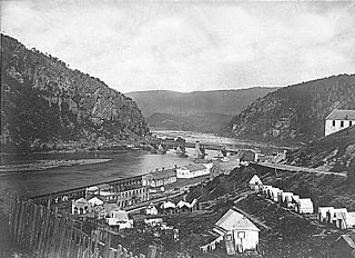
Harpers Ferry is a historic town in Jefferson County, West Virginia, in the lower Shenandoah Valley. The town's population was 269 at the 2020 United States census. Situated at the confluence of the Potomac and Shenandoah rivers, where Maryland, Virginia, and West Virginia meet, it is the easternmost town in West Virginia as well as its lowest point above sea level.

The Potomac River is a major river in the Mid-Atlantic region of the United States that flows from the Potomac Highlands in West Virginia to the Chesapeake Bay in Maryland. It is 405 miles (652 km) long, with a drainage area of 14,700 square miles (38,000 km2), and is the fourth-largest river along the East Coast of the United States. More than 6 million people live within its watershed.

Jefferson County is located in the Shenandoah Valley in the Eastern Panhandle of West Virginia. It is the easternmost county of the U.S. state of West Virginia. As of the 2020 census, the population was 57,701. Its county seat is Charles Town. The county was founded in 1801, and today is part of the Washington metropolitan area.

The Shenandoah Valley is a geographic valley and cultural region of western Virginia and the Eastern Panhandle of West Virginia in the United States. The Valley is bounded to the east by the Blue Ridge Mountains, to the west by the eastern front of the Ridge-and-Valley Appalachians, to the north by the Potomac River, to the south by the James River, and to the Southwest by the New River Valley. The cultural region covers a larger area that includes all of the Valley plus the Virginia Highlands to the west and the Roanoke Valley to the south. It is physiographically located within the Ridge and Valley Province and is a portion of the Great Appalachian Valley.
The Battle of Harpers Ferry was fought September 12–15, 1862, as part of the Maryland Campaign of the American Civil War. As Confederate Army General Robert E. Lee's Confederate army invaded Maryland, a portion of his army under Major General Thomas J. "Stonewall" Jackson surrounded, bombarded, and captured the Union garrison at Harpers Ferry, Virginia.

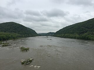
The Shenandoah River is the principal tributary of the Potomac River, 55.6 miles (89.5 km) long with two forks approximately 100 miles (160 km) long each, in the U.S. states of Virginia and West Virginia. The river and its tributaries drain the central and lower Shenandoah Valley and the Page Valley in the Appalachians on the west side of the Blue Ridge Mountains, in northwestern Virginia and the eastern panhandle of West Virginia. There is a hydroelectric plant along the Shenandoah River constructed in 2014 by Dominion.

U.S. Route 340 is a spur route of US 40, and runs from Greenville, Virginia, to Frederick, Maryland. In Virginia, it runs north–south, parallel and east of US 11, from US 11 north of Greenville via Waynesboro, Grottoes, Elkton, Luray, Front Royal, and Berryville to the West Virginia state line. A short separate piece crosses northern Loudoun County on its way from West Virginia to Maryland.

The Patowmack Canal, sometimes called the Potomac Canal, is a series of five inoperative canals located in Maryland and Virginia, United States, that was designed to bypass rapids in the Potomac River upstream of the present Washington, D.C., area. The most well known of them is the Great Falls skirting canal, whose remains are managed by the National Park Service since it is within Great Falls Park, an integral part of the George Washington Memorial Parkway.

Old Rag Mountain is a 3,284 feet (1,001 m) mountain near Sperryville in Madison County, Virginia. A part of the Blue Ridge Mountains, the peak is located within Shenandoah National Park and is the most popular hiking destination within the park.

Conococheague Creek, a tributary of the Potomac River, is a free-flowing stream that originates in Pennsylvania and empties into the Potomac River near Williamsport, Maryland. It is 80 miles (129 km) in length, with 57 miles (92 km) in Pennsylvania and 23 miles (37 km) in Maryland. The watershed of Conococheague Creek has an area of approximately 566 square miles (1,470 km2), out of which only 65 square miles (170 km2) are in Maryland.

The Rapidan River, flowing 88 miles (142 km) through north-central Virginia in the United States, is the largest tributary of the Rappahannock River. The two rivers converge just west of the city of Fredericksburg. The Rapidan River begins west of Doubletop Mountain in Shenandoah National Park where the Mill Prong meets the Laurel Prong at Rapidan Camp, approximately 3 miles (4.8 km) south of Big Meadows. The river defines the border of Orange County with Culpeper and Madison Counties.
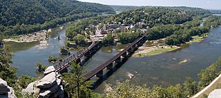
Harpers Ferry National Historical Park, originally Harpers Ferry National Monument, is located at the confluence of the Potomac and Shenandoah rivers in and around Harpers Ferry, West Virginia. The park includes the historic center of Harpers Ferry, notable as a key 19th-century industrial area and as the scene of John Brown's failed abolitionist uprising. It contains the most visited historic site in the state of West Virginia, John Brown's Fort.

Blue Ridge Mountain, also known as Blue Mountain, is the colloquial name of the westernmost ridge of the Blue Ridge Mountains in Northern Virginia and the eastern panhandle of West Virginia. The Appalachian Trail traverses the entire length of the mountain along its western slope and crest.

Virginius Island is a formerly inhabited island of some 12 acres (4.9 ha), on the Shenandoah River in Harpers Ferry, West Virginia. The island was created by the Shenandoah Canal, constructed by the Patowmack Company between 1806 and 1807, which separates it from the town of Harpers Ferry. The canal was constructed to enable boats to bypass rapids on the river, and also channel water to drive machinery. In the nineteenth century Virginius Island contained Harpers Ferry's industry and working-class housing: a boarding house and row houses. Virginius Island is part of the Harpers Ferry National Historical Park.
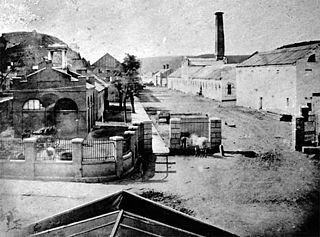
The Harpers Ferry Armory, more formally known as the United States Armory and Arsenal at Harpers Ferry, was the second federal armory created by the United States government; the first was the Springfield Armory. It was located in Harpers Ferry, Virginia, which since 1863 has been part of West Virginia. It was both an arsenal, manufacturing firearms, and an armory, a storehouse for firearms. Along with the Springfield Armory, it was instrumental in the development of machining techniques to make interchangeable parts of precisely the same dimensions.

Loudoun Heights, sometimes referred to as Loudoun Mountain, is the first peak of the Blue Ridge Mountain south of the Potomac River in Loudoun County, Virginia and Jefferson County, West Virginia. The northwestern slope is part of Harpers Ferry National Historical Park.
The Potomac Water Gap is a double water gap in the Blue Ridge Mountains, located at the intersection of the states of Virginia, West Virginia and Maryland, near Harpers Ferry. At 256 feet (78 m), it is the lowest crossing of the Blue Ridge Mountains.

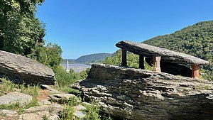
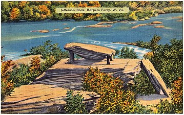
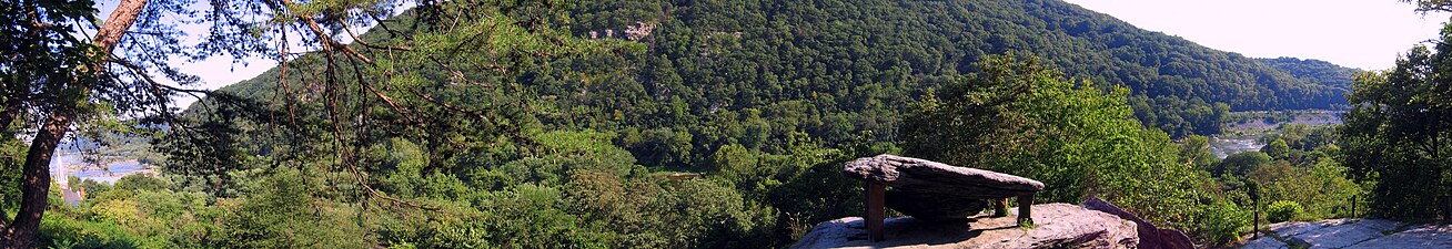
St. Peter's Roman Catholic Church in Harpers Ferry, West Virginia occupies a prominent location on the heights above Harpers Ferry. The original church was built in 1833 in a pseudo-Gothic style which it kept through the Civil War, being the only church in Harpers Ferry to escape destruction during the war. The church was extensively altered in 1896 in the then-popular Neo-Gothic style to produce the church seen today. The church commands a sweeping vista across the gorge of the Shenandoah River above its confluence with the Potomac River. The street along the side of the church building is part of the Appalachian Trail. A short trail leads from the church to Jefferson Rock. St. Peter's Church is a mission church of St. James in Charles Town. Mass is offered at the historic church every Sunday at 9:30 a.m.

The B & O Railroad Potomac River Crossing is a 15-acre (6.1 ha) historic site where a set of railroad bridges, originally built by the Baltimore and Ohio Railroad, span the Potomac River between Sandy Hook, Maryland and Harpers Ferry, West Virginia. The site was added to the National Register of Historic Places on February 14, 1978, for its significance in commerce, engineering, industry, invention, and transportation.

The Harpers Ferry Historic District comprises about one hundred historic structures in Harpers Ferry, West Virginia. The historic district includes the portions of the central town not included in Harpers Ferry National Historical Park, including large numbers of early 19th-century houses built by the United States Government for the workers at the Harpers Ferry Armory. Significant buildings and sites include the site of the Armory, the U.S Armory Potomac Canal, the Harpers Ferry Train Station, and Shenandoah Street, Potomac Street, and High or Washington Street. The National Historic Park essentially comprises the lower, flood-prone areas of the town, while the Historic District comprises the upper town.