Sharpsburg, Maryland

Last updated • 6 min readFrom Wikipedia, The Free Encyclopedia

Sharpsburg, Maryland
Town
Sharpsburg clock.JPG
A street clock in downtown Sharpsburg, October 2007
Seal of Sharpsburg, Maryland.png
Washington County Maryland Incorporated and Unincorporated areas Sharpsburg Highlighted.svg
Location of Sharpsburg, Maryland
Coordinates: 39°27′27″N77°45′05″W / 39.45750°N 77.75139°W / 39.45750; -77.75139
Country United States
State Maryland
County Washington
Settled1740
Founded1763
Incorporated 1832 [1]
Area
[2]
  Total0.22 sq mi (0.56 km2)
  Land0.22 sq mi (0.56 km2)
  Water0.00 sq mi (0.00 km2)
Elevation
[3]
427 ft (130 m)
Population
 (2020)
  Total560
  Density2,592.59/sq mi (1,001.67/km2)
Time zone UTC-5 (Eastern)
  Summer (DST) UTC-4 (EDT)
ZIP Code
21782
Area code(s) 301, 240
FIPS code 24-71600
GNIS feature ID2391408 [3]
Website sharpsburgmd.com

Sharpsburg is a town in Washington County, Maryland. The town is approximately 13 miles (21 km) south of Hagerstown. Its population was 560 at the 2020 census.

Contents

During the American Civil War, the Battle of Antietam, referred to as the Battle of Sharpsburg by the South, was fought on what is now Antietam National Battlefield, in the vicinity of Antietam Creek.

History

A visitor's sign at the Antietam National Battlefield near Sharpsburg, in June 2005 Bloodylane.JPG
A visitor's sign at the Antietam National Battlefield near Sharpsburg, in June 2005

The first American of European descent to own land in what would eventually become Sharpsburg was the one-time indian trader Edmund Cartledge. By the time Cartledge surveyed his "Hickory Tavern [4] " land tract in 1737, the Great Philadelphia Wagon Road was already well established over the path that would become Sharpsburg's main street. Hickory Tavern is noted in the patent as between the wagon road and Garrison Spring, today's Big Spring. Thousands of immigrants used this route of the wagon road traveling from Pennsylvania as far south as the Carolinas. [5]

On May 1, 1755, the road was used by Major general Edward Braddock, colonial governor Horatio Sharpe and several of Braddock's staff officers to reach Winchester, Virginia, while his 48th regiment took a longer route via today's Williamsport, Maryland. [5] Among the officers accompanying Braddock that day was a young Virginia militia officer named George Washington. [6]

At the end of the French and Indian War in 1763, Joseph Chapline founded a town, naming it in honor of his friend Horatio Sharpe, the Proprietary Governor of the Province of Maryland. Its original settlers were mostly of German or Swiss origin reaching the area from Pennsylvania via the great wagon road. They were a major force in leading to an increase in wheat production from the original agricultural dependence on tobacco.

Located east of the Potomac River, Sharpsburg attracted industry in the early 19th century, especially after the Chesapeake and Ohio Canal was extended to Sharpsburg in 1836. The town was incorporated in 1832.

Sharpsburg gained national recognition during the American Civil War, when Confederate General Robert E. Lee invaded Maryland with his Army of Northern Virginia in the summer of 1862 and was intercepted near the town by Union General George B. McClellan with the Army of the Potomac. The rival armies met on September 17, in the Battle of Antietam (also called the Battle of Sharpsburg). It would be the bloodiest single day in all American military annals, with a total of nearly 23,000 casualties to both sides. A few days earlier, the multi-sited Battle of South Mountain occurred at the three low-lying passes in South MountainCrampton's Gap, Turner's Gap, and Fox's Gap—where Lee's forces attempted to hold back the advancing Union regiments moving westward especially along the important National Road (now U.S. Route 40 Alternate) which is now a part of South Mountain State Battlefield Park.

The drawn battle is considered a turning point of the war, since it kept the Confederacy from winning a needed victory on Northern soil, which might have gained it European recognition. Lee's retreat gave Abraham Lincoln the opportunity he needed to issue his Emancipation Proclamation, declaring all slaves residing in rebelling Confederate territory against the federal government, to be "forever free". This act made it even more unlikely that Europe would grant diplomatic recognition to the South.

Sharpsburg claims its Memorial Day commemoration as one of the first in the U.S., having their 147th consecutive celebration in 2014. [7]

The town core was added to the National Register of Historic Places in 2008 as the Sharpsburg Historic District. [8] Also listed are the Antietam National Battlefield, William Chapline House, Good-Reilly House, William Hagerman Farmstead, Joseph C. Hays House, Jacob Highbarger House, Mount Airy, Piper House, Tolson's Chapel, Wilson-Miller Farm, and Woburn Manor. [9]

The Antietam National Battlefield is an important source of local tourism and activities.

Government

Town Council

Elected by voters to four-year terms:

Geography

According to the United States Census Bureau, the town has a total area of 0.23 square miles (0.60 km2), all land. [10]

Climate data for Sharpsburg, Maryland (1991–2020 normals, extremes 1998-present)
MonthJanFebMarAprMayJunJulAugSepOctNovDecYear
Record high °F (°C)73
(23)
80
(27)
85
(29)
94
(34)
95
(35)
99
(37)
101
(38)
99
(37)
98
(37)
93
(34)
84
(29)
80
(27)
101
(38)
Mean maximum °F (°C)65
(18)
65
(18)
76
(24)
86
(30)
89
(32)
93
(34)
95
(35)
94
(34)
91
(33)
84
(29)
75
(24)
65
(18)
96
(36)
Mean daily maximum °F (°C)41.2
(5.1)
44.2
(6.8)
52.5
(11.4)
64.7
(18.2)
73.5
(23.1)
82.0
(27.8)
86.1
(30.1)
84.8
(29.3)
78.1
(25.6)
66.8
(19.3)
55.7
(13.2)
44.8
(7.1)
64.5
(18.1)
Daily mean °F (°C)31.2
(−0.4)
33.6
(0.9)
40.7
(4.8)
51.7
(10.9)
61.2
(16.2)
70.1
(21.2)
74.2
(23.4)
72.9
(22.7)
65.9
(18.8)
54.4
(12.4)
43.9
(6.6)
35.1
(1.7)
52.9
(11.6)
Mean daily minimum °F (°C)21.1
(−6.1)
23.0
(−5.0)
29.0
(−1.7)
38.6
(3.7)
48.8
(9.3)
58.2
(14.6)
62.4
(16.9)
60.9
(16.1)
53.7
(12.1)
42.0
(5.6)
32.1
(0.1)
25.3
(−3.7)
41.3
(5.2)
Mean minimum °F (°C)4
(−16)
7
(−14)
15
(−9)
25
(−4)
34
(1)
45
(7)
52
(11)
51
(11)
41
(5)
29
(−2)
19
(−7)
11
(−12)
4
(−16)
Record low °F (°C)−3
(−19)
−6
(−21)
−4
(−20)
19
(−7)
29
(−2)
36
(2)
46
(8)
46
(8)
33
(1)
24
(−4)
12
(−11)
0
(−18)
−6
(−21)
Average precipitation inches (mm)3.13
(80)
2.41
(61)
3.72
(94)
3.60
(91)
4.57
(116)
4.16
(106)
4.28
(109)
3.27
(83)
4.40
(112)
3.41
(87)
3.08
(78)
3.46
(88)
43.49
(1,105)
Average snowfall inches (cm)7.3
(19)
9.5
(24)
2.5
(6.4)
0.1
(0.25)
0
(0)
0
(0)
0
(0)
0
(0)
0
(0)
0
(0)
0.4
(1.0)
4.2
(11)
24
(61.65)
Average extreme snow depth inches (cm)4
(10)
5
(13)
3
(7.6)
0
(0)
0
(0)
0
(0)
0
(0)
0
(0)
0
(0)
0
(0)
0
(0)
3
(7.6)
7
(18)
Average precipitation days (≥ 0.01 in)109111215111011101189127
Average snowy days (≥ 0.1 in)3310000000028
Source: NOAA [11]

Transportation

MD 34 eastbound along Main Street in Sharpsburg 2019-05-18 17 43 49 View east along Maryland State Route 34 (Main Street) at Maryland State Route 65 (Church Street) in Sharpsburg, Washington County, Maryland.jpg
MD 34 eastbound along Main Street in Sharpsburg

The primary means of travel to and from Sharpsburg is by road. The two main highways serving the town are Maryland Route 34, which follows Main Street, and Maryland Route 65, which ends at the intersection of Main Street and Church Street. MD 34 extends eastward to Boonsboro and continues westward to the Potomac River, where it crosses into Shepherdstown, West Virginia, as West Virginia Route 480. MD 65 proceeds northward to a junction with Interstate 70 and then continues to its terminus in Hagerstown.

Demographics

Historical population
CensusPop.Note
1870 1,001
1880 1,26025.9%
1890 1,163−7.7%
1900 1,080−7.1%
1910 960−11.1%
1920 832−13.3%
1930 818−1.7%
1940 8342.0%
1950 8663.8%
1960 861−0.6%
1970 833−3.3%
1980 721−13.4%
1990 659−8.6%
2000 6914.9%
2010 7052.0%
2020 560−20.6%
U.S. Decennial Census [12]

2010 census

As of the census [13] of 2010, there were 705 people, 285 households, and 192 families living in the town. The population density was 3,065.2 inhabitants per square mile (1,183.5/km2). There were 325 housing units at an average density of 1,413.0 per square mile (545.6/km2). The racial makeup of the town was 95.7% White, 0.4% African American, 0.1% Native American, and 3.7% from two or more races. Hispanic or Latino of any race were 2.1% of the population.

There were 285 households, of which 28.1% had children under the age of 18 living with them, 47.7% were married couples living together, 13.0% had a female householder with no husband present, 6.7% had a male householder with no wife present, and 32.6% were non-families. 25.3% of all households were made up of individuals, and 7% had someone living alone who was 65 years of age or older. The average household size was 2.47 and the average family size was 2.92.

The median age in the town was 42.8 years. 20.3% of residents were under the age of 18; 7.3% were between the ages of 18 and 24; 26.4% were from 25 to 44; 33.2% were from 45 to 64; and 12.8% were 65 years of age or older. The gender makeup of the town was 50.9% male and 49.1% female.

2000 census

As of the census [14] of 2000, there were 691 people, 286 households, and 193 families living in the town. The population density was 3,119.1 inhabitants per square mile (1,204.3/km2). There were 304 housing units at an average density of 1,372.2 per square mile (529.8/km2). The racial makeup of the town was 97.8% White, 0.4% African American, 0.6% Asian, 0.3% Hispanic or Latino, and 1.2% from two or more races.

There were 286 households, out of which 26.6% had children under the age of 18 living with them, 54.2% were married couples living together, 9.4% had a female householder with no husband present, and 32.5% were non-families. 26.2% of all households were made up of individuals, and 8.0% had someone living alone who was 65 years of age or older. The average household size was 2.42 and the average family size was 2.90.

In the town, the population was spread out, with 21.7% under the age of 18, 8.7% from 18 to 24, 29.1% from 25 to 44, 27.6% from 45 to 64, and 12.9% who were 65 years of age or older. The median age was 38 years. For every 100 females, there were 103.2 males. For every 100 females age 18 and over, there were 101.9 males.

The median income for a household in the town was $41,786, and the median income for a family was $52,875. Males had a median income of $37,500 versus $22,000 for females. The per capita income for the town was $20,917. About 1.1% of families and 3.1% of the population were below the poverty line, including none of those under age 18 and 5.6% of those age 65 or over.

Notable native

Related Research Articles

<span class="mw-page-title-main">Allegany County, Maryland</span> County in Maryland, United States

Allegany County is located in the northwestern part of the U.S. state of Maryland. As of the 2020 census, the population was 68,106. Its county seat is Cumberland. The name Allegany may come from a local Lenape word, welhik hane or oolikhanna, which means 'best flowing river of the hills' or 'beautiful stream'. A number of counties and a river in the Appalachian region of the U.S. are named Allegany, Allegheny, or Alleghany. Allegany County is part of the Cumberland metropolitan area. It is a part of the Western Maryland "panhandle".

<span class="mw-page-title-main">Washington County, Maryland</span> County in Maryland, United States

Washington County is located in the western part of the U.S. state of Maryland. As of the 2020 census, the population was 154,705. It is the most populous county in the Western Maryland region and its county seat is Hagerstown.

<span class="mw-page-title-main">Goldsboro, Maryland</span> Town in Maryland

Goldsboro is a town in Caroline County, Maryland, United States. William James Yeager is the current mayor. The population was 246 at the 2010 United States Census. The zip code is 21636. First known as Oldtown, it was renamed in 1870 for the prominent Goldsborough family who owned land in the area. Castle Hall was listed on the National Register of Historic Places in 1975.

<span class="mw-page-title-main">New Windsor, Maryland</span> Town in Maryland, United States

New Windsor is a town in Carroll County, Maryland, United States. The population was 1,398 at the 2020 census. It is located 6 miles (10 km) west of Westminster on Maryland Route 31.

<span class="mw-page-title-main">North East, Maryland</span> Town in Maryland, United States

North East is a town in Cecil County, Maryland, United States. It is located between Philadelphia and Baltimore. The population was 3,572 at the 2010 census.

<span class="mw-page-title-main">Braddock Heights, Maryland</span> Census-designated place in Maryland

Braddock Heights is an unincorporated community and census-designated place (CDP) in Frederick County, Maryland, United States. The population was 2,608 at the 2010 census. The local ZIP codes are 21714 and 21703.

<span class="mw-page-title-main">Burkittsville, Maryland</span> Town in Maryland, United States

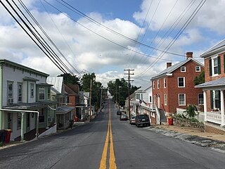
Burkittsville is a historic village in Frederick County, Maryland, United States. The village lies in the southern Middletown Valley along the eastern base of South Mountain.

<span class="mw-page-title-main">Middletown, Maryland</span> Town in Maryland

Middletown is a town in Frederick County, Maryland, United States. The population was 4,136 as of the 2010 census. Located in the Middletown Valley that stretches between the Catoctin Mountains on the east and South Mountain on the west, the town reportedly gained its name from its location midway between those ranges.

<span class="mw-page-title-main">Grantsville, Maryland</span> Town in Maryland, United States

Grantsville is a town in the northern part of Garrett County, Maryland, United States, near the Pennsylvania border. The population was 968 as of the 2020 census.

<span class="mw-page-title-main">Laytonsville, Maryland</span> Town in Maryland, United States

Laytonsville is a town in Montgomery County, Maryland, United States. The population was 572 at the 2020 census, up from 353 in 2010. Laytonsville was incorporated in 1892.

<span class="mw-page-title-main">Boonsboro, Maryland</span> Town in Maryland, United States

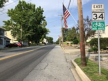
Boonsboro is a town in Washington County, Maryland, United States, located at the foot of South Mountain. It nearly borders Frederick County and is proximate to the Antietam National Battlefield. The population was 3,779 at the 2020 census.

<span class="mw-page-title-main">Funkstown, Maryland</span> Town in Maryland, United States

Funkstown is a town in Washington County, Maryland, United States. The population was 904 at the 2010 census.

<span class="mw-page-title-main">Keedysville, Maryland</span> Town in Maryland, United States

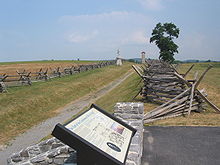
Keedysville is a town in Washington County, Maryland, United States. The population was 1,152 at the 2010 census.

<span class="mw-page-title-main">Smithsburg, Maryland</span> Town in Maryland, United States

Smithsburg is a town in Washington County, Maryland, United States. The population was 2,975 at the 2010 census. Smithsburg is close to the former Fort Ritchie army base and just west of the presidential retreat Camp David.

<span class="mw-page-title-main">Wharton Township, Fayette County, Pennsylvania</span> Township in Pennsylvania, United States

Wharton Township is a township in Fayette County, Pennsylvania, United States. The population was 3,360 at the 2020 census, down from 3,575 at the 2010 census. The Uniontown Area School District serves the region.

<span class="mw-page-title-main">Addison Township, Pennsylvania</span> Township in Pennsylvania, United States

Addison Township is a township in Somerset County, Pennsylvania, United States. The population was 932 at the 2020 census. It is part of the Johnstown, Pennsylvania, Metropolitan Statistical Area. The township is named for Alexander Addison, the first president judge overseeing Somerset County.

<span class="mw-page-title-main">Carpendale, West Virginia</span> Town in West Virginia, United States

Carpendale is a town in Mineral County, West Virginia, United States, and part of the Cumberland, MD-WV Metropolitan Statistical Area'. The population was 861 at the 2020 census. Carpendale was incorporated on January 2, 1990, by the Circuit Court. The town is a combination of three subdivisions of which its name reflects: Carpenters Addition, Millerdale I, and Millerdale II. There are no stores in Carpendale and there is only one road in and out of the town.

<span class="mw-page-title-main">Ridgeley, West Virginia</span> Town in West Virginia, United States

Ridgeley is a town in Mineral County, West Virginia, United States, and part of the Cumberland Metropolitan Statistical Area. The population was 590 at the 2020 census.

<span class="mw-page-title-main">Hampstead, Maryland</span> Town in Maryland, United States

Hampstead is a town in Carroll County in the U.S. state of Maryland. The population was 6,323 at the 2010 census.

<span class="mw-page-title-main">Sharpsburg, North Carolina</span> Town in North Carolina, United States

Sharpsburg is a town in Edgecombe, Nash, and Wilson counties, North Carolina, United States. It is part of the Rocky Mount, North Carolina Metropolitan Statistical Area. The population was 2,024 at the 2010 Census.

References

  1. "Sharpsburg". Maryland Manual. Archived from the original on March 16, 2017. Retrieved June 27, 2017.
  2. "2020 U.S. Gazetteer Files". United States Census Bureau. Archived from the original on March 5, 2023. Retrieved April 26, 2022.
  3. 1 2 U.S. Geological Survey Geographic Names Information System: Sharpsburg, Maryland
  4. P.G.Co. land record Book #5. p. 377.
  5. 1 2 Ellis, Ted (2017). Braddock's Neglected Route The Lost Fork of the Conococheague Road. Columbia, SC, USA. ISBN   9780998833002.{{cite book}}: CS1 maint: location missing publisher (link)
  6. Sargent, Winthrop (1856). The History of an Expedition Against Ft. Du Quesne. Philadelphia, Pennsylvania, USA: J.B. Lippincott & Co.
  7. "Memorial Day Commemoration in Sharpsburg". U.S. Department of the Interior. National Park Service. May 1, 2009. Archived from the original on November 4, 2012. Retrieved May 25, 2009.
  8. "WEEKLY LIST OF ACTIONS TAKEN ON PROPERTIES: 12/22/08 THROUGH 12/24/08". National Register of Historic Places. National Park Service. March 2, 2009. Archived from the original on January 11, 2009. Retrieved March 3, 2009.
  9. "National Register Information System". National Register of Historic Places . National Park Service. July 9, 2010.
  10. "US Gazetteer files 2010". United States Census Bureau. Archived from the original on January 25, 2012. Retrieved January 25, 2013.
  11. "NowData – NOAA Online Weather Data". National Oceanic and Atmospheric Administration. Archived from the original on November 13, 2020. Retrieved May 28, 2022.
  12. "Census of Population and Housing". Census.gov. Archived from the original on July 17, 2022. Retrieved June 4, 2015.
  13. "U.S. Census website". United States Census Bureau. Archived from the original on July 9, 2021. Retrieved January 25, 2013.
  14. "U.S. Census website". United States Census Bureau. Archived from the original on July 9, 2021. Retrieved January 31, 2008.