Washington County, Maryland

Last updated

Washington County
Burnsidebridge.jpg
Burnside's Bridge in Washington County, site of heavy combat during the Battle of Antietam
Flag of Washington County, Maryland.svg
Washington County md seal.png
Map of Maryland highlighting Washington County.svg
Location within the U.S. state of Maryland
Maryland in United States.svg
Maryland's location within the U.S.
Coordinates: 39°36′N77°49′W / 39.6°N 77.81°W / 39.6; -77.81
CountryFlag of the United States.svg United States
StateFlag of Maryland.svg  Maryland
FoundedSeptember 6, 1776
Named for George Washington
Seat Hagerstown
Largest cityHagerstown
Area
  Total467 sq mi (1,210 km2)
  Land458 sq mi (1,190 km2)
  Water9.6 sq mi (25 km2)  2.0%
Population
 (2020)
  Total154,705 Increase2.svg
  Density330/sq mi (130/km2)
Time zone UTC−5 (Eastern)
  Summer (DST) UTC−4 (EDT)
Congressional district 6th
Website www.washco-md.net

Washington County is located in the western part of the U.S. state of Maryland. As of the 2020 census, the population was 154,705. [1] It is the most populous county in the Western Maryland region and its county seat is Hagerstown. [2]

Contents

Washington County was the first county in the United States to be named for the Revolutionary War general (and later President) George Washington. Washington County is one of three Maryland counties recognized by the Appalachian Regional Commission as being part of Appalachia. [3] The county borders southern Pennsylvania to the north, Northern Virginia to the south, and the Eastern Panhandle of West Virginia to the south and west. Washington County is included in the Hagerstown-Martinsburg, MD-WV Metropolitan Statistical Area, which is also included in the Washington-Baltimore-Arlington, DC-MD-VA-WV-PA Combined Statistical Area.

History

The Washington County seal from 1950 to 1988; de facto as it was never officially adopted. Seal of Washington County, Maryland (1950-1988).png
The Washington County seal from 1950 to 1988; de facto as it was never officially adopted.

The western portions of the Province of Maryland (including present Washington County) were incorporated into Prince George's County in 1696. This original county included six current counties. The first to be created was Frederick, separated from Prince George's County in 1748.

Following independence, the sovereign State of Maryland formed Washington County on September 6, 1776, by the division of Frederick County. At the same time, a portion of Frederick County became part of the newly created Montgomery County along with portions from Prince George's County and Charles' County, and was named for General Richard Montgomery. Washington County as created included land later to become Allegany County (created in 1789) and Garrett County (included in Allegany County when it was created in 1789, but separated from Allegany County in 1872). Washington County thus originally included the entire western part of the state. [4]

A number of properties in the county are listed on the National Register of Historic Places. [5]

Geography

According to the U.S. Census Bureau, the county has a total area of 467 square miles (1,210 km2), of which 458 square miles (1,190 km2) is land and 9.6 square miles (25 km2) (2.0%) is water. [6]

Washington County is located in the Appalachian Mountains, stretching from the Ridge-and-Valley Country in the west to South Mountain in the east, which is an extension of the Blue Ridge. Much of the county lies in the broad Hagerstown Valley between these two zones; the valley is part of the Great Appalachian Valley that continues southward into Virginia and West Virginia as the Shenandoah Valley and northward into Pennsylvania as the Cumberland Valley.

The county is bordered to the north by the Mason–Dixon line with Pennsylvania, to the south by the Potomac River and the states of Virginia and West Virginia, to the west by Sideling Hill Creek and Allegany County, Maryland, and to the east by Frederick County and South Mountain.

Adjacent counties

Major highways

View south along I-81 from I-70 in Washington County 2019-07-10 11 52 50 View south along Interstate 81 from the overpass for Interstate 70 in Halfway, Washington County, Maryland.jpg
View south along I-81 from I-70 in Washington County

Demographics

Historical population
CensusPop.Note
1790 15,822
1800 18,65017.9%
1810 18,7300.4%
1820 23,07523.2%
1830 25,2689.5%
1840 28,85014.2%
1850 30,8486.9%
1860 31,4171.8%
1870 34,71210.5%
1880 38,56111.1%
1890 39,7823.2%
1900 45,13313.5%
1910 49,6179.9%
1920 59,69420.3%
1930 65,88210.4%
1940 68,8384.5%
1950 78,88614.6%
1960 91,21915.6%
1970 103,82913.8%
1980 113,0868.9%
1990 121,3937.3%
2000 131,9238.7%
2010 147,43011.8%
2020 154,7054.9%
U.S. Decennial Census [7]
1790-1960 [8] 1900-1990 [9]
1990-2000 [10] 2010–2018 [11]

2000 census

As of the census of 2010, there were 147,430 people, 49,726 households, and 34,112 families residing in the county. The population density was 315 inhabitants per square mile (122/km2). There were 52,972 housing units at an average density of 116 per square mile (45/km2). The racial makeup of the county was 89.71% White or Caucasian, 7.77% Black or African American, 0.18% Native American, 0.80% Asian, 0.04% Pacific Islander, 0.46% from other races, and 1.04% from two or more races. 1.19% of the population were Hispanic or Latino of any race, 32.1% identified as being of German ancestry, 21.4% American, 8.8% Irish, and 8.4% English ancestry.

There were 49,726 households, out of which 31.30% had children under the age of 18 living with them, 54.00% were married couples living together, 10.70% had a female householder with no husband present, and 31.40% were non-families. 26.00% of all households were made up of individuals, and 11.10% had someone living alone who was 65 years of age or older. The average household size was 2.46 and the average family size was 2.96.

In the county, the population was spread out, with 23.40% under the age of 18, 8.10% from 18 to 24, 31.30% from 25 to 44, 23.00% from 45 to 64, and 14.20% who were 65 years of age or older. The median age was 37 years. For every 100 females, there were 104.50 males. For every 100 females age 18 and over, there were 104.00 males.

2010 census

As of the 2010 United States Census, there were 147,430 people, 55,687 households, and 37,506 families residing in the county. [12] The population density was 322.1 inhabitants per square mile (124.4/km2). There were 60,814 housing units at an average density of 132.8 per square mile (51.3/km2). [13] The racial makeup of the county was 85.1% white, 9.6% black or African American, 1.4% Asian, 0.2% American Indian, 1.1% from other races, and 2.6% from two or more races. Those of Hispanic or Latino origin made up 3.5% of the population. [12] In terms of ancestry, 31.7% were German, 14.1% were Irish, 9.8% were English, 8.5% were American, and 5.1% were Italian. [14]

Of the 55,687 households, 32.4% had children under the age of 18 living with them, 50.6% were married couples living together, 12.0% had a female householder with no husband present, 32.6% were non-families, and 26.6% of all households were made up of individuals. The average household size was 2.50 and the average family size was 3.01. The median age was 39.7 years. [12]

The median income for a household in the county was $52,994 and the median income for a family was $65,811. Males had a median income of $47,622 versus $34,225 for females. The per capita income for the county was $26,588. About 7.7% of families and 10.4% of the population were below the poverty line, including 14.1% of those under age 18 and 8.8% of those age 65 or over. [15]

Communities

Hagerstown Hagerstown Downtown Potomac St.JPG
Hagerstown
Williamsport Williamsport Maryland.jpg
Williamsport

City

Towns

Census-designated places

The Census Bureau recognizes the following census-designated places in the county:

Hancock Hancock main street.jpg
Hancock

Unincorporated communities

Sharpsburg Bloodylane.JPG
Sharpsburg

Politics and government

Federal representation

The county is located within Maryland's 6th congressional district. The representative of the district currently is David Trone (D).

Like most of Appalachia, German-influenced and Unionist Western Maryland, [16] Washington County is solidly Republican. The last Democrat to carry Washington County at a Presidential level was Lyndon Johnson during his 1964 landslide win over Barry Goldwater, although between 1888 and 1940 the county was a consistent bellwether for all Presidential elections.

Voter Registration and Party Enrollment of Washington County [17]
PartyTotalPercentage
Democratic 31,71231.60%
Republican 44,40244.25%
Independents, unaffiliated, and other24,22724.15%
Total100,341100.00%
United States presidential election results for Washington County, Maryland [18] [19]
Year Republican Democratic Third party
No.%No.%No.%
2020 40,22459.35%26,04438.42%1,5112.23%
2016 40,99862.13%21,12932.02%3,8645.86%
2012 36,07457.48%25,04239.90%1,6392.61%
2008 34,16955.47%26,24542.61%1,1861.93%
2004 36,91763.76%20,38735.21%6001.04%
2000 27,94858.88%18,22138.38%1,3012.74%
1996 21,43450.86%16,48139.11%4,22710.03%
1992 21,97747.56%16,49535.70%7,73616.74%
1988 25,91263.76%14,40835.45%3180.78%
1984 27,11866.68%13,32932.78%2190.54%
1980 22,90158.60%14,11836.12%2,0645.28%
1976 20,19455.95%15,90244.05%00.00%
1972 24,23469.27%10,03928.70%7122.04%
1968 16,05047.13%11,26633.08%6,73719.78%
1964 12,75639.11%19,85860.89%00.00%
1960 17,82853.28%15,63246.72%00.00%
1956 19,45562.72%11,56237.28%00.00%
1952 17,65358.08%12,65741.64%840.28%
1948 11,88752.53%10,58846.79%1550.68%
1944 12,22751.83%11,36548.17%00.00%
1940 11,05443.76%14,12555.91%830.33%
1936 10,61942.96%14,05056.84%490.20%
1932 8,92943.50%11,37055.39%2281.11%
1928 12,40467.78%5,81631.78%810.44%
1924 7,46054.21%4,62033.57%1,68212.22%
1920 8,75754.75%6,85242.84%3862.41%
1916 5,09345.88%5,64250.83%3653.29%
1912 1,90719.99%4,58948.10%3,04431.91%
1908 4,65049.59%4,51848.18%2092.23%
1904 4,58151.86%4,06446.01%1882.13%
1900 5,47552.05%4,86246.22%1821.73%
1896 5,42853.57%4,38243.24%3233.19%
1892 4,37347.16%4,66750.33%2332.51%

State representation

Washington County is represented by two senators in the Maryland State Senate. Member George C. Edwards (R), serves the 1st district in Maryland and Andrew A. Serafini (R), serves in the 2nd district. The county also is represented in Maryland General Assembly’s other primary division, the Maryland House of Delegates. Delegates who stand for Washington County include: Mike McKay (R) for District 1C, Neil Parrot (R) and William Wivell (R) for District 2A and Paul Cordermen (R) for District 2B. [20]

County government

Washington County’s “leader” is known as the County Administrator. Currently, Kirk C. Downey serves as the Interim Administrator. However, Washington County's County Commissioners exercise executive powers as they exist in the government of the county.

The County Commissioners in Washington County comprise the traditional form of county government in Maryland. Current members include: Terry Baker (Vice President), Randall Wagner, Cort Meinelschmidt, Jeffrey A. Cline (President), and Wayne K. Keefer. [21]

Boonsboro Downtown Boonsboro, Maryland.jpg
Boonsboro

Economy

In 2000, the median income for a household in the county was $40,617, and the median income for a family was $48,962. Males had a median income of $34,917 versus $24,524 for females. The per capita income for the county was $20,062. About 7.00% of families and 9.50% of the population were below the poverty line, including 12.30% of those under age 18 and 9.50% of those age 65 or over.
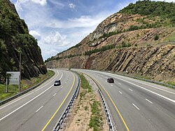
According to the Maryland Department of Business and Economic Development, the following were the major employers in the county (excluding post offices, state government, and local governments, but including public institutions of higher education): [22]

EmployerEmployees
(Nov. 2014) [22]
Meritus Health2,730
Citi 2,700
First Data 2,322
Volvo Group 1,350
The Bowman Group718
FedEx Ground 648
Staples Inc. 597
Hagerstown Community College 594
Merkle Response Management Group545
Arc of Washington County500
Direct Mail Processors500
Walmart/Sam's Club 500
Sierra Nevada Corp. 486
Giant Food Stores/
Martin's Food Markets
420
Weis Markets 400
Brook Lane Health Services395
Lehigh Phoenix360
A.C.&T350
Susquehanna Bancshares 345
Dot Foods 312
JLG Industries 300
Home Depot 296
Lowe's 276
Thompson's Gas & Electric Service275
United Parcel Service (UPS)274
CertainTeed 250
Darden Restaurants 250
Sheetz 250
Tractor Supply250
Homewood Retirement Centers249
NMS Healthcare of Hagerstown240
Horizon Goodwill Industries 229
C. William Hetzer225
FedEx Freight 225

Washington County is top in the state for commercial production of fruits, tree nuts, and berries. [23]

Parks and recreation

Sideling Hill man-made mountain pass on I-68/U.S. 40 near Hancock 2019-07-14 13 12 11 View west along Interstate 68 and U.S. Route 40 (National Freeway) from the Victor Cushwa Memorial Bridge as it passes through the Sideling Hill Road Cut in Forest Park, Washington County, Maryland.jpg
Sideling Hill man-made mountain pass on I-68/U.S. 40 near Hancock

National parks

State parks

Museums, historic sites, and other points of interest

Education

Washington County Public Schools administers public schools in the county. See Washington County Public Schools – School Directory for a detailed listing of elementary, middle, high, and other schools.

High schools

Colleges and universities

Notable residents and natives

See also

Related Research Articles

<span class="mw-page-title-main">Allegany County, Maryland</span> County in Maryland, United States

Allegany County is located in the northwestern part of the U.S. state of Maryland. As of the 2020 census, the population was 68,106. Its county seat is Cumberland. The name Allegany may come from a local Lenape word, welhik hane or oolikhanna, which means 'best flowing river of the hills' or 'beautiful stream'. A number of counties and a river in the Appalachian region of the U.S. are named Allegany, Allegheny, or Alleghany. Allegany County is part of the Cumberland metropolitan area. It is a part of the Western Maryland "panhandle".

<span class="mw-page-title-main">Morgan County, West Virginia</span> County in West Virginia, United States

Morgan County is a county located in the U.S. state of West Virginia. As of the 2020 census, the population was 17,063. Its county seat is Berkeley Springs. The county was formed in 1820 from parts of Hampshire and Berkeley Counties and named in honor of General Daniel Morgan, prominent soldier of the American Revolutionary War. The county and town of Bath are considered an excellent jumping off point for exploring the Potomac and Cacapon Rivers valleys just to the north and west. Along with also being a tourist destination hosting numerous local artists, mineral water spas, and a large amount of outdoor recreation that includes fishing, boating, wildlife, hunting, and mountain scenery. The region is known for the famed Apple Butter Festival held annually in October. Morgan County is also the home of an important silica mine, part of U.S. Silica.

<span class="mw-page-title-main">Cumberland, Maryland</span> City in Maryland

Cumberland is a city in and the county seat of Allegany County, Maryland, United States. At the 2020 census, the city had a population of 19,076. Located on the Potomac River, Cumberland is a regional business and commercial center for Western Maryland and the Potomac Highlands of West Virginia. It is the primary city of the Cumberland metropolitan area, which had 95,044 residents in 2020.

<span class="mw-page-title-main">LaVale, Maryland</span> Census-designated place in Maryland, United States

LaVale is a census-designated place (CDP) in Allegany County, Maryland, United States. It is part of the Cumberland, MD-WV Metropolitan Statistical Area. The population was 3,551 at the 2010 census.

<span class="mw-page-title-main">Midland, Maryland</span> Town in Maryland, United States

Midland is a town in Allegany County, Maryland, United States, along the Georges Creek Valley. It is part of the Cumberland, MD-WV Metropolitan Statistical Area. The population was 446 at the 2010 census. Midland was founded in 1850 as a coal-mining community, though today only some strip mining remains.

<span class="mw-page-title-main">Middletown, Maryland</span> Town in Maryland

Middletown is a town in Frederick County, Maryland, United States. The population was 4,136 as of the 2010 census. Located in the Middletown Valley that stretches between the Catoctin Mountains on the east and South Mountain on the west, the town reportedly gained its name from its location midway between those ranges.

<span class="mw-page-title-main">Boonsboro, Maryland</span> Town in Maryland, United States

Boonsboro is a town in Washington County, Maryland, United States, located at the foot of South Mountain. It nearly borders Frederick County and is proximate to the Antietam National Battlefield. The population was 3,779 at the 2020 census.

<span class="mw-page-title-main">Clear Spring, Maryland</span> Town in Maryland, United States

Clear Spring is a town in Washington County, Maryland, United States. The population was 358 at the 2010 census.

<span class="mw-page-title-main">Funkstown, Maryland</span> Town in Maryland, United States

Funkstown is a town in Washington County, Maryland, United States. The population was 904 at the 2010 census.

<span class="mw-page-title-main">Keedysville, Maryland</span> Town in Maryland, United States

Keedysville is a town in Washington County, Maryland, United States. The population was 1,152 at the 2010 census.

<span class="mw-page-title-main">Sharpsburg, Maryland</span> Town in Maryland, United States

Sharpsburg is a town in Washington County, Maryland. The town is approximately 13 miles (21 km) south of Hagerstown. Its population was 705 at the 2010 census.

<span class="mw-page-title-main">Smithsburg, Maryland</span> Town in Maryland, United States

Smithsburg is a town in Washington County, Maryland, United States. The population was 2,975 at the 2010 census. Smithsburg is close to the former Fort Ritchie army base and just west of the presidential retreat Camp David.

<span class="mw-page-title-main">Cumberland Valley Township, Bedford County, Pennsylvania</span> Township in Pennsylvania, United States

Cumberland Valley Township is a township in Bedford County, Pennsylvania, United States. The population was 1,445 at the 2020 census.

<span class="mw-page-title-main">Antrim Township, Pennsylvania</span> Township in Pennsylvania, United States

Antrim Township is a township in Franklin County, Pennsylvania, United States. The population was 15,778 at the 2020 census, an increase over the figure of 12,504 tabulated in 2000. It was named after County Antrim in Northern Ireland.

<span class="mw-page-title-main">Washington Township, Franklin County, Pennsylvania</span> Township in Pennsylvania, United States

Washington Township is a township in Franklin County, Pennsylvania, United States. The population was 14,897 at the 2020 census, up from 14,009 at the 2010 census.

<span class="mw-page-title-main">Bolivar, West Virginia</span> Town in West Virginia, United States

Bolivar is a town in Jefferson County, West Virginia, United States. The population was 1,072 at the 2020 census. The town is named for South American revolutionary leader Simón Bolívar. Located in West Virginia's Eastern Panhandle, it is part of the northwestern fringes of the Washington metropolitan area.

<span class="mw-page-title-main">Berkeley Springs, West Virginia</span> Town in West Virginia, United States

Berkeley Springs is a town in, and the county seat of, Morgan County, West Virginia, United States, in the state's Eastern Panhandle. Berkeley Springs is also commonly used to refer to the area in and around the Town of Bath. In 1776, the Virginia Legislature incorporated a town around the springs and named it Bath. Since 1802, it has been referred to by the name of its original post office, Berkeley Springs. The population was 758 at the 2020 census. It is part of the Hagerstown–Martinsburg metropolitan area.

<span class="mw-page-title-main">Paw Paw, West Virginia</span> Town in West Virginia, United States

Paw Paw is a town in Morgan County, West Virginia, United States. The population was 410 at the 2020 census. The town is known for the nearby Paw Paw Tunnel. Paw Paw was incorporated by the Circuit Court of Morgan County on April 8, 1891, and named after pawpaw, a wild fruit that grows in abundance throughout this region. Paw Paw is the westernmost incorporated community in Morgan County, and the Hagerstown-Martinsburg, MD-WV Metropolitan Statistical Area.

<span class="mw-page-title-main">Western Maryland</span> Region in Maryland, US

Western Maryland, also known as the Maryland Panhandle, is the portion of the U.S. state of Maryland that typically consists of Washington, Allegany, and Garrett counties. The region is bounded by Preston County, West Virginia, to the west, the Mason–Dixon line (Pennsylvania) to the north, and the Potomac River and West Virginia to the south. At one point, at the town of Hancock, the northern and southern boundaries are separated by just 1.8 miles, the narrowest stretch in the state.

<span class="mw-page-title-main">Hagerstown, Maryland</span> City in Maryland, United States

Hagerstown is a city in and the county seat of Washington County, Maryland, United States. The population was 43,527 at the 2020 census. Hagerstown ranks as Maryland's sixth-largest incorporated city and is the largest city in the Maryland Panhandle.

References

  1. "U.S. Census Bureau QuickFacts: Washington County, Maryland". www.census.gov. Retrieved March 14, 2022.
  2. "Find a County". National Association of Counties. Retrieved June 7, 2011.
  3. "Counties in Appalachia - Appalachian Regional Commission". www.arc.gov. Retrieved October 11, 2015.
  4. , Washington County, Maryland History and Genealogy, 2006. Retrieved 2008.
  5. "National Register Information System". National Register of Historic Places . National Park Service. April 24, 2008.
  6. "2010 Census Gazetteer Files". United States Census Bureau. August 22, 2012. Archived from the original on September 13, 2014. Retrieved September 14, 2014.
  7. "U.S. Decennial Census". United States Census Bureau. Retrieved September 14, 2014.
  8. "Historical Census Browser". University of Virginia Library. Retrieved September 14, 2014.
  9. "Population of Counties by Decennial Census: 1900 to 1990". United States Census Bureau. Retrieved September 14, 2014.
  10. "Census 2000 PHC-T-4. Ranking Tables for Counties: 1990 and 2000" (PDF). United States Census Bureau. Archived (PDF) from the original on March 27, 2010. Retrieved September 14, 2014.
  11. "State & County QuickFacts". United States Census Bureau. Retrieved August 24, 2013.
  12. 1 2 3 "DP-1 Profile of General Population and Housing Characteristics: 2010 Demographic Profile Data". United States Census Bureau. Archived from the original on February 13, 2020. Retrieved January 22, 2016.
  13. "Population, Housing Units, Area, and Density: 2010 - County". United States Census Bureau. Archived from the original on February 13, 2020. Retrieved January 22, 2016.
  14. "DP02 SELECTED SOCIAL CHARACTERISTICS IN THE UNITED STATES – 2006-2010 American Community Survey 5-Year Estimates". United States Census Bureau. Archived from the original on February 13, 2020. Retrieved January 22, 2016.
  15. "DP03 SELECTED ECONOMIC CHARACTERISTICS – 2006-2010 American Community Survey 5-Year Estimates". United States Census Bureau. Archived from the original on February 13, 2020. Retrieved January 22, 2016.
  16. Levine, Mark V.; ‘Standing Political Decisions and Critical Realignment: The Pattern of Maryland Politics, 1872-1948’; The Journal of Politics , volume 38, no. 2 (May, 1976), pp. 292-325
  17. "Summary of Voter Activity Report" (PDF). Maryland State Board of Elections. October 2022. Retrieved November 30, 2022.
  18. Leip, David. "Dave Leip's Atlas of U.S. Presidential Elections". uselectionatlas.org. Retrieved June 12, 2018.
  19. "Géographie électorale" [Electoral geography] (in French). Retrieved March 11, 2023.
  20. "ROSTER BY COUNTY • 2017 • MARYLAND GENERAL ASSEMBLY" (PDF). Archived from the original (PDF) on June 25, 2017. Retrieved December 1, 2023.
  21. "County Commissioners".
  22. 1 2 Major Employers in Washington County, Maryland, Maryland Department of Business and Economic Development (Nov. 2014 data).
  23. "Census of Agriculture - State and County Profiles - Maryland". USDA, National Agricultural Statistics Service . 2017. Retrieved July 29, 2022.

39°36′N77°49′W / 39.60°N 77.81°W / 39.60; -77.81