Rockville, Maryland

Last updated

Rockville, Maryland
The Mayor and Council of Rockville [1]
Rockville, Maryland Infobox Montage 1.png
Downtown Rockville in 2001, the Montgomery County Judicial Center in 2010, the Rockville Town Square in 2010, the Beall-Dawson House in 2005, and downtown Rockville in 2008
Flag of Rockville, Maryland.svg
Seal of Rockville, Maryland.svg
Montgomery County Maryland Incorporated and Unincorporated areas Rockville Highlighted.svg
Location in Montgomery County and Maryland
USA Maryland relief location map.svg
Red pog.svg
Rockville
Location in Maryland
Usa edcp relief location map.png
Red pog.svg
Rockville
Rockville (the United States)
Coordinates: 39°04′48″N77°08′34″W / 39.08000°N 77.14278°W / 39.08000; -77.14278
CountryFlag of the United States.svg United States
State Flag of Maryland.svg  Maryland
County Flag of Montgomery County, Maryland.svg Montgomery
Settled1717
Founded1803
Incorporated 1860
Government
  Type Council–manager
  MayorMonique Ashton [2]
Area
[3]
  Total13.64 sq mi (35.33 km2)
  Land13.60 sq mi (35.23 km2)
  Water0.04 sq mi (0.09 km2)
Elevation
[4]
449 ft (137 m)
Population
 (2020)
  Total67,117
  Density4,933.62/sq mi (1,904.92/km2)
Time zone UTC−5 (EST)
  Summer (DST) UTC−4 (EDT)
ZIP code
20847-53 & 20857
Area codes 301, 240
FIPS code 24-67675
GNIS feature ID2390645 [4]
Website www.rockvillemd.gov OOjs UI icon edit-ltr-progressive.svg

Rockville is a city in and the county seat of Montgomery County, Maryland, United States, and is part of the Washington metropolitan area. The 2020 census tabulated Rockville's population at 67,117, [5] making it the fourth-largest incorporated city in Maryland. [6]

Contents

Rockville, along with neighboring Gaithersburg and Bethesda, is at the core of the Interstate 270 Technology Corridor which is home to numerous software and biotechnology companies as well as several federal government institutions. The city, one of the major retail hubs in Montgomery County, has several upscale regional shopping centers.

History

Early history

Situated in the Piedmont region and crossed by three creeks (Rock Creek, Cabin John Creek, and Watts Branch), Rockville provided an excellent refuge for semi-nomadic Native Americans as early as 8000 BC. By the first millennium BC, a few of these groups had settled down into year-round agricultural communities that exploited the native flora, including sunflowers and marsh elder. By AD 1200, these early groups (dubbed Montgomery Indians by later archaeologists) were increasingly drawn into conflict with the Senecas and Susquehannocks who had migrated south from Pennsylvania and New York. Within the present-day boundaries of the city, six prehistoric sites have been uncovered and documented, along with numerous artifacts several thousand years old. By 1700, under pressure from European colonists, the majority of these original inhabitants had been driven away.

The indigenous population carved a path on the high ground, known as Sinequa Trail, which is now downtown Rockville. Later, the Maryland Assembly set the standard of 20 feet for main thoroughfares and designated the Rock Creek Main Road or Great Road to be built to this standard. In the mid-18th century, Lawrence Owen opened a small inn on the road. The place, known as Owen's Ordinary, took on greater prominence when, on April 14, 1755, Major General Edward Braddock stopped at Owen's Ordinary on a start of a mission from George Town (now Washington, D.C.) to press British claims of the western frontier. The location of the road, near the present Rockville Pike, was strategically located on higher ground, making it dry year-round. [7] :6–9

18th century

The first land patents in the Rockville area were obtained by Arthur Nelson between 1717 and 1735. Within three decades, the first permanent buildings in what would become the center of Rockville were established on this land. Still a part of Prince George's County at this time, the growth of Daniel Dulaney's Frederick Town prompted the separation of the western portion of the county, including Rockville, into Frederick County in 1748.

Being a small, unincorporated town, early Rockville was known by a variety of names, including Owen's Ordinary, Hungerford's Tavern, and Daley's Tavern. The first recorded mention of the settlement later known as Rockville dates to the Braddock Expedition in 1755. On April 14, one of the approximately 2,000 men who were accompanying General Braddock through wrote the following: "we marched to larance Owings or Owings Oardianary, a Single House, it being 18 miles and very dirty." Owen's Ordinary was a small rest stop on Rock Creek Main Road (later the Rockville Pike), which stretched from George Town to Frederick Town, and was then one of the largest thoroughfares in the colony of Maryland.

On September 6, 1776, [8] the Maryland Constitutional Convention agreed to a proposal introduced by Thomas Sprigg Wootton wherein Frederick County, the largest and most populous county in Maryland, would be divided into three smaller subdivisions. The southern portion of the county, of which Rockville was a part, was named Montgomery County. The most populous and prosperous urban center in this new county was George Town, but its location at the far southern edge rendered it worthless as a seat of local government. Rockville, a small but centrally located and well-traveled town, was chosen as the seat. At the time, Rockville did not have a name; it was generally called Hungerford's Tavern, after the well-known tavern in it. [8] After being named the county seat, the village was referred to by all as Montgomery Court House. [8] The tavern served as the county courthouse, and it held its first such proceedings on May 20, 1777. [8]

In 1784, William Prather Williams, a local landowner, hired a surveyor to lay out much of the town. [8] In his honor, many took to calling the town Williamsburg. [8] In practice, however, Williamsburg and Montgomery Court House were used interchangeably. Rockville came to greater prominence when Montgomery County was created and later when George Town was ceded to the federal government to create the District of Columbia. [7]

19th century

Stone marker on corner of Vinson Street and Maryland Avenue, placed there in 1803 when Rockville's streets were laid out. "BR" stands for "Beginning of Rockville". Rockville Cornerstone.jpg
Stone marker on corner of Vinson Street and Maryland Avenue, placed there in 1803 when Rockville's streets were laid out. "BR" stands for "Beginning of Rockville".
Rockville Railroad Station, built in 1873 Rockville railroad station.jpg
Rockville Railroad Station, built in 1873
Rockville in 1879 Map of Rockville 1879.jpg
Rockville in 1879

A proposal to name the town Wattsville, after the nearby Watts Branch, failed because the stream was later considered too small to give its name to the town. [8] On July 16, 1803, when the area was officially entered into the county land records with the name "Rockville", derived from Rock Creek. [8] [10] Nevertheless, the name Montgomery Court House continued to appear on maps and other documents through the 1820s.

By petition of Rockville's citizens, the Maryland General Assembly incorporated the village on March 10, 1860. During the American Civil War, General George B. McClellan stayed at the Beall Dawson house in 1862. In addition, General J.E.B. Stuart and an army of 8,000 Confederate cavalrymen marched through and occupied Rockville on June 28, 1863, [11] while on their way to Gettysburg and stayed at the Prettyman house. Jubal Anderson Early also crossed through Rockville on his way to and from his 1864 attack on Washington.

In 1913, on the birthday of Jefferson Davis, the United Daughters of the Confederacy erected a statue near the Rockville courthouse dedicated to Confederate soldiers from Montgomery County. [12] [13] The monument was removed in 2017 as part of a wave of removals of Confederate monuments and memorials in response to the 2015 Charleston church shooting, and is now located in White's Ferry. [14]

In 1873, the Baltimore and Ohio Railroad arrived, making Rockville easily accessible from Washington, D.C. (See Metropolitan Branch.) In July 1891, the Tennallytown and Rockville Railway inaugurated Rockville's first trolley service connecting to the Georgetown and Tennallytown Railway terminus at Western Avenue and Wisconsin Avenue.

20th century to today

Downtown Rockville, 1970 Looking north on what is now 355 in Rockville 1970.jpg
Downtown Rockville, 1970
Downtown Rockville, 2001 Rockvillemd.jpg
Downtown Rockville, 2001
Rockville Town Center, 2006 Rockville town center2.jpg
Rockville Town Center, 2006
Downtown Rockville, 2009 Rockville - Maryland Ave at Middle Ln.jpg
Downtown Rockville, 2009
Rockville, Maryland - Looking Northwest RockvilleMaryland-Northwest.jpg
Rockville, Maryland - Looking Northwest

The newly opened railroad provided service from Georgetown to Rockville, connecting Rockville to Washington, D.C., by trolley. Trolley service operated for four decades, until, eclipsed by the growing usage of the automobile, service was halted in August 1935. The Blue Ridge Transportation Company provided bus service for Rockville and Montgomery County from 1924 through 1955. After 1955, Rockville would not see a concerted effort to develop a public transportation infrastructure until the 1970s, when the Washington Metropolitan Area Transit Authority (WMATA) began work to extend the Washington Metro into Rockville and extended Metrobus service into Montgomery County. The Rockville station of Washington Metro began service on July 25, 1984, and the Twinbrook station began service on December 15, 1984. Metrobus service was supplemented by Montgomery County's own Ride On bus service starting in 1979. MARC, Maryland's Rail Commuter service, serves Rockville with its Brunswick line. From Rockville MARC provides service to Washington Union Station in Washington D.C. (southbound), and Frederick and Martinsburg, West Virginia (northbound), as well as intermediate points. Amtrak, the national passenger rail system, provides service from Rockville to Chicago and Washington D.C.

The mid-20th century saw substantial growth in Rockville, especially with the annexation of the Twinbrook subdivision in 1949, which added hundreds of new homes and thousands of new residents to the city. In 1954, Congressional Airport closed, and its land was sold to developers to build residences and a commercial shopping center. [15] The shopping center, named Congressional Plaza, opened in 1958. [16] These new areas provided affordable housing and grew quickly with young families eager to start their lives following World War II.

During the Cold War, it was considered safer to remain in Rockville than to evacuate during a hypothetical nuclear attack on Washington, D.C. Bomb shelters were built, including the largest one at Glenview Mansion and 15 other locations. The I-270 highway was designated as an emergency aircraft landing strip. Two Nike missile launcher sites were located on Muddy Branch and Snouffer School Roads until the mid-1970s. [7] :163

From the 1960s, Rockville's town center, formerly one of the area's commercial centers, suffered from a period of decline. Rockville soon became the first city in Maryland to enter into a government funded urban renewal program. This resulted in the demolition of most of the original business district. Included in the plan was the unsuccessful Rockville Mall, which failed to attract either major retailers or customers and was demolished in 1994, various government buildings such as the new Montgomery County Judicial Center, and a reorganization of the road plan near the Courthouse. Unfortunately, the once-promising plan was for the most part a disappointment. Although efforts to restore the town center continue, the majority of the city's economic activity has since relocated along Rockville Pike (MD Route 355/Wisconsin Avenue). In 2004, Rockville Mayor Larry Giammo announced plans to renovate the Rockville Town Square, including building new stores and housing and relocating the city's library. In the past year, the new Rockville Town Center has been transformed and includes a number of boutique-like stores, restaurants, condominiums and apartments, as well as stages, fountains and the Rockville Library. [17] The U.S. Nuclear Regulatory Commission's headquarters is just south of the city's corporate limits.

The city is closely associated with the neighboring towns of Kensington and the unincorporated census-designated place, North Bethesda. The Music Center at Strathmore, an arts and theater center, opened in February 2005 in the latter of these two areas and is presently the second home of the Baltimore Symphony Orchestra, and the Fitzgerald Theatre in Rockville Civic Center Park has provided diverse entertainment since 1960. In 1998, Regal Cinemas opened in Town Center [7] :217 and the city annexed 900 acres of land. [18]

The city also has a brass band in the British style.

The R.E.M. song "(Don't Go Back To) Rockville", released in 1984, was written by Mike Mills about not wanting his girlfriend Ingrid Schorr to return to Rockville, Maryland. [19]

In 1975, F. Scott Fitzgerald and Zelda Fitzgerald's caskets were reinterred at St. Mary's Catholic Church in Rockville, Maryland where his father, Edward, and a number of Key family members had been buried. [20]

Historic places

Historic structures on the Register in and around downtown Rockville are:

Rockville vicinity

Geography

Boundaries of Rockville in 2004 RockvilleMap.gif
Boundaries of Rockville in 2004

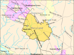
According to the United States Census Bureau, the city has a total area of 13.57 square miles (35.15 km2), of which 13.51 square miles (34.99 km2) is land and 0.06 square miles (0.16 km2) is water. [22]

Climate

The climate in this area is characterized by hot, humid summers and generally mild to cool winters. According to the Köppen Climate Classification system Rockville has a humid subtropical climate, abbreviated "Cfa" on climate maps. [23] According to the United States Department of Agriculture, Rockville is in hardiness zone 7a, [24] meaning that the average annual minimum winter temperature is 0 to 5 °F (−18 to −15 °C). [25] The average first frost occurs on October 21, and the average final frost occurs on April 16. [26]

Climate data for Rockville, Maryland, 1981–2010 normals, extremes 1907–2007
MonthJanFebMarAprMayJunJulAugSepOctNovDecYear
Record high °F (°C)78
(26)
82
(28)
89
(32)
100
(38)
97
(36)
102
(39)
105
(41)
104
(40)
99
(37)
93
(34)
85
(29)
80
(27)
105
(41)
Mean maximum °F (°C)62.7
(17.1)
67.4
(19.7)
77.8
(25.4)
84.9
(29.4)
89.0
(31.7)
92.5
(33.6)
95.0
(35.0)
93.0
(33.9)
89.5
(31.9)
80.7
(27.1)
74.3
(23.5)
65.4
(18.6)
96.2
(35.7)
Mean daily maximum °F (°C)40.4
(4.7)
43.7
(6.5)
53.3
(11.8)
64.5
(18.1)
72.8
(22.7)
81.3
(27.4)
85.0
(29.4)
83.2
(28.4)
75.8
(24.3)
64.8
(18.2)
54.7
(12.6)
43.8
(6.6)
63.6
(17.6)
Daily mean °F (°C)33.7
(0.9)
36.4
(2.4)
44.8
(7.1)
55.2
(12.9)
63.8
(17.7)
72.8
(22.7)
76.9
(24.9)
75.2
(24.0)
67.7
(19.8)
56.2
(13.4)
46.9
(8.3)
37.2
(2.9)
55.6
(13.1)
Mean daily minimum °F (°C)27.0
(−2.8)
29.2
(−1.6)
36.2
(2.3)
45.9
(7.7)
54.8
(12.7)
64.3
(17.9)
68.8
(20.4)
67.2
(19.6)
59.7
(15.4)
47.7
(8.7)
39.1
(3.9)
30.5
(−0.8)
47.5
(8.6)
Mean minimum °F (°C)5.4
(−14.8)
8.5
(−13.1)
16.2
(−8.8)
27.4
(−2.6)
36.8
(2.7)
45.8
(7.7)
52.2
(11.2)
50.7
(10.4)
40.4
(4.7)
29.4
(−1.4)
21.0
(−6.1)
11.9
(−11.2)
1.8
(−16.8)
Record low °F (°C)−13
(−25)
−12
(−24)
1
(−17)
18
(−8)
28
(−2)
35
(2)
38
(3)
39
(4)
28
(−2)
20
(−7)
10
(−12)
−12
(−24)
−13
(−25)
Average precipitation inches (mm)2.88
(73)
2.71
(69)
3.61
(92)
3.22
(82)
4.13
(105)
3.49
(89)
3.67
(93)
2.90
(74)
3.83
(97)
3.29
(84)
3.53
(90)
3.00
(76)
40.26
(1,024)
Average snowfall inches (cm)8.3
(21)
3.4
(8.6)
2.6
(6.6)
0.1
(0.25)
0.0
(0.0)
0.0
(0.0)
0.0
(0.0)
0.0
(0.0)
0.0
(0.0)
0.0
(0.0)
0.5
(1.3)
2.2
(5.6)
17.1
(43.35)
Average precipitation days (≥ 0.01 in)9.78.110.710.111.89.710.07.89.08.08.28.9112.0
Average snowy days (≥ 0.1 in)3.01.91.10.10.00.00.00.00.00.00.31.37.7
Source: NOAA (mean maxima/minima 19712000) [27] [28]

Demographics

Historical population
CensusPop.Note
1900 1,110
1910 1,1816.4%
1920 1,145−3.0%
1930 1,42224.2%
1940 2,04744.0%
1950 6,934238.7%
1960 26,090276.3%
1970 42,73963.8%
1980 43,8112.5%
1990 44,8352.3%
2000 47,3885.7%
2010 61,20929.2%
2020 67,1179.7%
U.S. Decennial Census [29]
2010–2020 [5]

Income

The median income for a household in the city as of 2020 was $111,797. [30] As of 2007, the median income for a family was $98,257. Males had a median income of $53,764 versus $38,788 for females. In 2015, the per capita income for the city was $49,399. [30] 7.8% of the population and 5.6% of families were below the poverty line. Out of the total population, 8.9% of those under the age of 18 and 7.9% of those 65 and older were living below the poverty line.

2010 census

As of the census [31] of 2010, there were 61,209 people, 23,686 households, and 15,524 families residing in the city. The population density was 4,530.6 inhabitants per square mile (1,749.3/km2). There were 25,199 housing units at an average density of 1,865.2 per square mile (720.2/km2). The racial makeup of the city was 60.4% White (52.8% non-Hispanic white), 9.6% African American, 0.3% Native American, 20.6% Asian, 5.3% from other races, and 3.8% from two or more races. Hispanic or Latino of any race were 14.3% of the population.

There were 23,686 households, of which 31.8% had children under the age of 18 living with them, 52.3% were married couples living together, 9.9% had a female householder with no husband present, 3.4% had a male householder with no wife present, and 34.5% were non-families. 27.0% of all households were made up of individuals, and 9.5% had someone living alone who was 65 years of age or older. The average household size was 2.54 and the average family size was 3.08.

The median age in the city was 38.7 years. And 21.5% of residents were under the age of 18; 7.2% were between the ages of 18 and 24; 31.1% were from 25 to 44; 26.3% were from 45 to 64; and 14% were 65 years of age or older. The gender makeup of the city was 47.9% male and 52.1% female.

Economy

Choice Hotels, Westat, and Bethesda Softworks/ZeniMax Media are headquartered in Rockville.

Looking West; Rockville Maryland, The Tower Building RockvilleMaryland-TowerBuilding.jpg
Looking West; Rockville Maryland, The Tower Building

Largest employers

According to the city's 2023 Annual Comprehensive Financial Report, [32] the top employers in the city are:

#EmployerEmployees
1 Montgomery County 5,165
2 Montgomery County Public Schools 2,500
3 U.S. Nuclear Regulatory Commission 2,391
4 Montgomery College 2,000
5 Westat 1,750
6 Northwestern Mutual Life Insurance 623
7 Lockheed Martin Information Systems 565
8City of Rockville501
9 Choice Hotels 500
10 Quest Diagnostics 500

Sports

Government

Presidential election results
Presidential election results in Rockville [34]
Year Democratic Republican Others
2020 79.5%26,11518.0% 5,8992.5% 828
2016 73.9%20,72219.8% 5,5556.3% 1,757

Rockville has a council-manager form of government. [35]

In November 2023, Rockville voted in the 67th election for Mayor and Council with voters electing Monique Ashton as mayor. Six councilmembers were also elected: Kate Fulton, Adam Van Grack, Izola (Zola) Shaw, David Myles, Marissa Valeri, and Barry Jackson. [2]

Mayor

The current mayor of Rockville is Monique Ashton. [2]

Rockville was incorporated in 1860, but its early records were destroyed by Confederate soldiers in July 1864. [36]

Past mayors of Rockville include:

Mayors of Rockville [37]
NameTenurePartyNotes
  William V. Bouic [37] 1888-1890 [37] Democratic
Daniel F. Owens [37] 1890 [37]
William V. Bouic [37] 1890-1891 [37]
Hattersley W. Talbott [37] 1892-1893 [37]
Jacob Poss [37] 1893-1894 [37]
John G. England [37] 1894-1896 [37]
Joseph Reading [37] 1896-1898 [37]
Spencer C. Jones [37] 1898-1901 [37]
Hattersley W. Talbott [37] 1901-1906 [37]
Lee Offutt [37] 1906-1916 [37]
Willis Burdette [37] 1916-1918 [37]
Lee Offutt [37] 1918-1920 [37]
O. M. Linthicum [37] 1920-1924 [37]
Charles G. Holland [37] 1924-1926 [37]
J. Roger Spates [37] 1926-1932 [37]
Douglas Blandford [37] 1932-1946 [37]
G. LaMar Kelly [37] 1946-1952 [37]
Daniel Weddle [37] 1952-1954 [37]
Dickran Y. Hovsepian [37] 1954-1958 [37]
Alexander J. Greene [37] 1958-1962 [37]
Frank A. Ecker [37] 1962-1968 [37]
Achilles M. Tuchtan [37] 1968-1972 [37]
Matthew J. McCartin [37] 1972-1974 [37]
William E. Hanna, Jr. [37] 1974-1982 [37]
John R. Freeland [37] 1982-1984 [37]
Viola D. Hovesepian [37] 1984-1985 [37] Appointed mayor [37]
 Steven Van Grack [37] 1985-1987 [37] Independent [38]
  Douglas M. Duncan [37] 1987-1993 [37]
James Coyle [37] 1993-1995 [37]
Rose G. Krasnow [37] 1995-2001 [37]
 Larry Giammo [37] 2001-2007 [37] Independent [39]
 Susan R. Hoffmann [37] 2007-2009 [37]
 Phyllis R. Marcuccio [37] 2009-2013 [37]
 Bridget Donnell Newton2013–2023 [40]
Monique M. Ashton2023–present [41]

Representative body

Rockville City Hall, 2010 Rockville City Hall.jpg
Rockville City Hall, 2010

Rockville was a four-member City Council, whose members, along with the mayor, serve as the governing body of the city. In 2023, the City Council voted to expand the Council from four members to six, along with the mayor. [42] The six councilmembers are Kate Fulton, Adam Van Grack, Izola (Zola) Shaw, David Myles, Marissa Valeri, and Barry Jackson.

Rockville has 26 boards and commissions: Animal Matters Board, Board of Appeals, Board of Supervisors of Elections, Charter Review Commission, Community Policing Advisory Board, Compensation Commission, Cultural Arts Commission, Environment Commission, Ethics Commission, Financial Advisory Board, Historic District Commission, Human Rights Commission, Human Services Advisory Commission, Landlord-Tenant Affairs Commission, Personnel Appeals Board, Planning Commission, Recreation and Park Advisory Board, Retirement Board, Rockville Economic Development Inc. (REDI), Rockville Housing Enterprises, Rockville Recreation and Parks Foundation, Rockville Seniors Inc. (RSI), Rockville Sister City Corporation, Senior Citizens Commission, Sign Review Board, and Traffic and Transportation Commission. Boards and commissions allows members of the community to partner with city staff to shape Rockville's future by sharing expertise and advising the Mayor and Council. [43]

Education

Rockville is served by the Montgomery County Public Schools system. Public high schools in Rockville include Thomas S. Wootton High School, Richard Montgomery High School, and Rockville High School. Prior to integration in 1961, black students were educated at George Washington Carver High School in Rockville. [44] The John L. Gildner Regional Institute for Children and Adolescents provides education for children with special educational needs. [45]

St. Elizabeth Catholic School of the Roman Catholic Archdiocese of Washington is in Rockville. [46]

Private schools located near Rockville (with Rockville postal addresses) include:

Montrose Christian School in North Bethesda has closed.

Higher education

The Montgomery College (MC), main campus is located within Rockville and enrolls more than 15,000 students as of March 2019. [47] The college is accredited by the Middle States Association of Colleges and Schools.

Additional institutions of higher education in Rockville include the University of Maryland Global Campus (main campus is in Adelphi, Maryland), the Johns Hopkins University Montgomery County Campus (main campus is in Baltimore), and the Universities at Shady Grove, a collaboration of nine Maryland public degree-granting institutions, all with Rockville addresses but outside the city limits.

Public library

The Rockville Memorial Library is available to the residents of Rockville. The Rockville Memorial Library offers services for residents and visitors to access books, databases, newspapers, magazines, and internet access. [48]

Transportation

I-270 northbound in Rockville 2019-07-12 11 25 04 View north along Interstate 270 (Washington National Pike) from the overpass for West Gude Drive in Rockville, Montgomery County, Maryland.jpg
I-270 northbound in Rockville

Roads and highways

The most prominent highway directly serving Rockville is Interstate 270. I-270 is the main highway leading northwest out of metropolitan Washington, D.C., beginning at Interstate 495 (the Capital Beltway) and proceeding northwestward to Interstate 70 in Frederick. Maryland Route 355 was the precursor to I-270 and follows a parallel route, and now serves as the main commercial roadway through Rockville and neighboring communities. Other state highways serving Rockville directly include Maryland Route 28, Maryland Route 189, Maryland Route 586, Maryland Route 660 and Maryland Route 911. Interstate 370 and Maryland Route 200 do not directly enter the city, but pass just outside the city limits.

Public transportation

The Washington Metro Red Line rail system can be accessed at Rockville station and Twinbrook station. The Brunswick Line of the MARC commuter rail system runs to and from Washington, D.C., and can be accessed at Rockville Station. Amtrak trains also serve Rockville.

Bus service connects Rockville directly to the regional transit hub at Baltimore–Washington International Airport, and to downtown Baltimore via the Maryland Transit Administration ICC Bus and the Baltimore Light Rail. Ride On buses provides service within the city and to places within the county like Gaithersburg, Clarksburg and Silver Spring.

Law enforcement

The city is served by the Rockville City Police Department and is aided by the Montgomery County Police Department as directed by the relevant authorities. [49]

Notable people

Sister cities

Rockville has two sister cities:

Rockville's sister city relationship with Yilan City gained notoriety as diplomats from the Embassy of China, Washington, D.C. unsuccessfully attempted to scuttle the agreement. [61] [62]

Although not a sister city, Rockville also has friendly relations with another city:

See also

Related Research Articles

<span class="mw-page-title-main">Montgomery County, Maryland</span> County in Maryland, United States

Montgomery County is the most populous county in the U.S. state of Maryland. As of the 2020 census, the county's population was 1,062,061, increasing by 9.3% from 2010. The county seat is Rockville, and Germantown is the most populous place in the county. The county is adjoined to Washington, D.C., the nation's capital, and is part of the Washington metropolitan area and the Washington–Baltimore combined statistical area. Most of the county's residents live in Silver Spring, Bethesda, Germantown, and the incorporated cities of Rockville and Gaithersburg.

<span class="mw-page-title-main">Bethesda, Maryland</span> Census-designated place in Maryland, United States

Bethesda is an unincorporated, census-designated place in southern Montgomery County, Maryland, United States. It is located just northwest of Washington, D.C. According to the 2020 census, the community had a total population of 68,056. It takes its name from a local church, the Bethesda Meeting House, which in turn took its name from Jerusalem's Pool of Bethesda. The National Institutes of Health's main campus and the Walter Reed National Military Medical Center are in Bethesda, in addition to several corporate and government headquarters.

<span class="mw-page-title-main">Garrett Park, Maryland</span> Town in Maryland, United States

Garrett Park is a town in Montgomery County, Maryland, United States. It was named after a former president of the Baltimore and Ohio Railroad, Robert W. Garrett. The population was 996 at the 2020 census. Garrett Park is home to Garrett Park Elementary School, located just outside the town proper.

<span class="mw-page-title-main">Kensington, Maryland</span> Town in Maryland, United States

Kensington is a U.S. town in Montgomery County, Maryland. The population was 2,122 at the 2020 census. Greater Kensington encompasses the entire 20895 ZIP code, with a population of 19,753 in 2020.

<span class="mw-page-title-main">Wheaton, Maryland</span> Census-designated place in Maryland, United States

Wheaton is a census-designated place in Montgomery County, Maryland, United States, situated north of Washington, D.C., and northwest of downtown Silver Spring. Wheaton takes its name from Frank Wheaton (1833–1903), a career officer in the United States Army and volunteer from Rhode Island in the Union Army who rose to the rank of major-general while serving before, during and after the Civil War.

<span class="mw-page-title-main">Darnestown, Maryland</span> Census-designated place in the United States

Darnestown is a United States census-designated place (CDP) and an unincorporated area in Montgomery County, Maryland. The CDP is 17.70 square miles (45.8 km2) with the Potomac River as its southern border and the Muddy Branch as much of its eastern border. Seneca Creek borders portions of its north and west sides. The Travilah, North Potomac, and Germantown census-designated places are adjacent to it, as is the city of Gaithersburg. Land area for the CDP is 16.39 square miles (42.4 km2). As of the 2020 census, the Darnestown CDP had a population of 6,723, while the village of Darnestown is considerably smaller in size and population. Downtown Washington, D.C. is about 22 miles (35 km) to the southeast.

<span class="mw-page-title-main">North Bethesda, Maryland</span> Census-designated place in Maryland, United States

North Bethesda is an unincorporated, census-designated place (CDP) in Montgomery County, Maryland, United States, located just north-west of the U.S. capital of Washington, D.C. It had a population of 50,094 as of the 2020 census. Among its neighborhoods, the centrally-located, urbanizing district of White Flint is the commercial and residential hub of North Bethesda. The Pike & Rose development and the Pike District is an initiative of Montgomery County to brand and market this region as "North Bethesda's Urban Core". The WMATA North Bethesda metro station and Grosvenor-Strathmore metro station serve the region.

<span class="mw-page-title-main">North Potomac, Maryland</span> Census-designated place named North Potomac in Maryland, United States

North Potomac is a census-designated place and unincorporated area in Montgomery County, Maryland, United States. It is located less than 5 miles (8.0 km) north of the Potomac River, and is about 20 miles (32 km) from Washington, D.C. It has a population of 23,790 as of 2020.

<span class="mw-page-title-main">Travilah, Maryland</span> Census-designated place in Maryland

Travilah is a United States census-designated place and an unincorporated area in Montgomery County, Maryland. It is 17.28 square miles (44.8 km2) located along the north side of the Potomac River, and surrounded by the communities of Potomac, North Potomac, and Darnestown—all census-designated places. It had a population of 11,985 as of the 2020 census.

<span class="mw-page-title-main">Germantown, Maryland</span> Census-designated place in Maryland, United States

Germantown is an urbanized census-designated place in Montgomery County, Maryland. With a population of 91,249 as of the 2020 census, it is the third-most populous community in Maryland, after Baltimore and Columbia. Germantown is located approximately 28 miles (45 km) outside the U.S. capital of Washington, D.C., and is an important part of the Washington metropolitan area.

<span class="mw-page-title-main">Thomas S. Wootton High School</span> Public secondary school in Rockville, Montgomery, Maryland, United States

Thomas S. Wootton High School or Wootton High School(WHS) is a public high school in Rockville, Maryland. Its namesake is Thomas S. Wootton, the founder of Montgomery County. The school was founded in 1970 and is part of the Montgomery County Public Schools system.

<span class="mw-page-title-main">Yilan City</span> County-administered city in Republic of China

Yilan City is a county-administered city and the county seat of Yilan County, Taiwan. The city lies on the north side of the Lanyang River.

<span class="mw-page-title-main">Montgomery County Public Schools (Maryland)</span> Public school district in Maryland, US

Montgomery County Public Schools (MCPS) is a public school district that serves Montgomery County, Maryland. With 210 schools, it is the largest school district in the state of Maryland. For the 2022–23 school year, the district had about 160,554 students taught by about 13,994 teachers, 86.4 percent of whom had a master's degree or equivalent. MCPS receives nearly half of the county's budget—47% in 2023.

<span class="mw-page-title-main">Interstate 270 (Maryland)</span> Highway in Maryland

Interstate 270 (I-270) is a 34.7-mile (55.8 km) auxiliary Interstate Highway in the U.S. state of Maryland that travels from I-495 just north of Bethesda in Montgomery County north to I-70 in the city of Frederick in Frederick County. It consists of the 32.6-mile (52.5 km) mainline as well as a 2.1-mile (3.4 km) spur that provides access to and from southbound I-495. I-270 is known as the Washington National Pike, and makes up the easternmost stretch of the Dwight D. Eisenhower Highway. Most of the southern part of the route in Montgomery County passes through suburban areas around Rockville and Gaithersburg that are home to many biotech firms. This portion of I-270 is up to 12 lanes wide and consists of a local–express lane configuration as well as high-occupancy vehicle lanes that are in operation during peak travel times. North of the Gaithersburg area, the road continues through the northern part of Montgomery County, passing Germantown and Clarksburg as a six- to eight-lane highway with an HOV lane in the northbound direction only. North of here, I-270 continues through rural areas into Frederick County and toward the city of Frederick as a four-lane freeway.

<span class="mw-page-title-main">Maryland Route 355</span> State highway in Montgomery and Frederick Counties, Maryland, United States

Maryland Route 355 (MD 355) is a 36.75-mile (59.14 km) north–south road in western central Maryland in the United States. The southern terminus of the route is in Bethesda in Montgomery County, where Wisconsin Avenue meets the county's border with Washington, D.C. The northern terminus is just north of a bridge over Interstate 70 (I-70)/U.S. Route 40 (US 40) in the city of Frederick in Frederick County, where the road continues north as Market Street through Frederick towards MD 26.

<span class="mw-page-title-main">Maryland Route 187</span> State highway in Montgomery County, Maryland, United States, known as Old Georgetown Road

Maryland Route 187 is a state highway in the U.S. state of Maryland. Known as Old Georgetown Road, the highway runs 5.32 miles (8.56 km) from MD 355 and MD 410 in Bethesda north to Executive Boulevard in North Bethesda. MD 187 is a four- to six-lane highway that runs parallel to MD 355 through suburban areas of southern Montgomery County. The highway was paved through Bethesda by 1910. The remainder of MD 187 was constructed in the mid- to late 1920s. The highway was relocated at its northern end and expanded to a divided highway over most of its length in the late 1960s. MD 187's interchanges with Interstate 270 (I-270) and I-495 were built in the late 1950s and early 1960s, respectively; the former interchange was reconstructed in the early 2000s. The northern terminus was cut back from MD 355 to Executive Boulevard in 2016.

<span class="mw-page-title-main">Streetcars in Washington, D.C., and Maryland</span>

Streetcars and interurbans operated in the Maryland suburbs of Washington, D.C., between 1890 and 1962.

<span class="mw-page-title-main">Seneca, Maryland</span> Unincorporated community in Maryland, United States

Seneca is an unincorporated community in Montgomery County, Maryland, United States. It is located near the intersection of River Road and Seneca Creek, not far from the Chesapeake and Ohio Canal and Potomac River. Its history goes back before the American Revolutionary War and it thrived when the canal was operating—having several warehouses, mills, a store, a hotel, and a school. Fighting occurred in the area on more than one occasion during the American Civil War. The community declined as the C&O Canal declined.

<span class="mw-page-title-main">Julie Palakovich Carr</span> American politician

Julie Palakovich Carr is an American politician from Maryland. She is a member of the Democratic Party who currently serves in the Maryland House of Delegates, representing District 17 in Montgomery County. She previously served on the Rockville City Council.

<span class="mw-page-title-main">History of Montgomery County, Maryland</span>

The History of Montgomery County, Maryland begins prior to 1688 when the first tract of land in what is now Montgomery County was granted by Charles I in a charter to the first Lord Baltimore. Much later, the creation of Montegomery county became the goal of colonist, Thomas S. Wootton when, on August 31, 1776, he introduced a measure to form a new county from Frederick County, Maryland to aid area residents in simplifying their business affairs. The measure passed, thus creating the new political entity of Montegomery County in the Maryland Colony.

References

  1. "Section 1. - City Incorporated; General Powers". Rockville City Code: General Ordinances of the City. Rockville, Maryland: The Mayor and Council of Rockville. February 26, 1990. Archived from the original on April 5, 2015. Retrieved March 17, 2015. The inhabitants of the City of Rockville, Montgomery County, are a body corporate by the name of 'The Mayor and Council of Rockville,' and by that name may have perpetual succession, sue and be sued, and have and use a common seal. (Res. No. 8-78; Res. No. 24-60)
  2. 1 2 3 "Mayor & Council | Rockville, MD - Official Website". www.rockvillemd.gov. Archived from the original on April 11, 2021. Retrieved December 30, 2023.
  3. "2020 U.S. Gazetteer Files". United States Census Bureau. Archived from the original on March 5, 2023. Retrieved April 26, 2022.
  4. 1 2 U.S. Geological Survey Geographic Names Information System: Rockville, Maryland
  5. 1 2 "QuickFacts: Rockville city, Maryland". United States Census Bureau. Archived from the original on March 9, 2022. Retrieved September 5, 2021.
  6. "Maryland at a Glance". Maryland Manual On-Line. September 1, 2022. Archived from the original on June 4, 2023. Retrieved May 24, 2023.
  7. 1 2 3 4 McGuckian, Eileen S. (2001). Rockville: Portrait of a City. Franklin, Tennessee: Hillsboro Press. ISBN   1-57736-235-7.
  8. 1 2 3 4 5 6 7 8 Proctor, John Clagett (May 20, 1934). "Rockville Among Old Maryland Towns". Washington Evening Star. p. 76. Archived from the original on February 25, 2024. Retrieved December 22, 2016.
  9. Tom (December 14, 2012). "Map of Rockville in 1879". Ghosts of DC. Archived from the original on February 20, 2019. Retrieved February 20, 2019.
  10. "Profile for Rockville Maryland, MD". ePodunk. Archived from the original on February 10, 2012. Retrieved August 25, 2012.
  11. "Capture of a Wagon Train: One Hundred and Seventy-eight Wagons and Over One Thousand Mules Gobbled Up: The Rebels in Possession of Rockville". Washington Evening Star. June 29, 1863. p. 2. Archived from the original on February 25, 2024. Retrieved December 22, 2016.
  12. "The Confederate Monument, a War Memorial". The Historical Marker Database. Archived from the original on August 19, 2017. Retrieved August 18, 2017.
  13. Mark Walston (July 21, 2017). "Looking Back at the Creation of the County's Confederate Memorials". Bethesda Beat. Archived from the original on August 19, 2017. Retrieved August 19, 2017.
  14. Bill Turque (July 24, 2017). "Confederate statue moved from Rockville courthouse over the weekend". The Washington Post . Archived from the original on August 19, 2017. Retrieved August 19, 2017.
  15. "Congressional Airport Sold For Dwellings". The Washington Post. April 4, 1954. p. M6. ProQuest   148631747.
  16. Goodman, S. Oliver (May 1, 1958). "New Rockville Shop Center Is Dedicated". The Washington Post. p. C14. ProQuest   148990982.
  17. Archived June 17, 2007, at the Wayback Machine
  18. "Rockville City Police Department". September 2, 1999. Archived from the original on September 2, 1999.{{cite web}}: CS1 maint: bot: original URL status unknown (link)
  19. Black, Johnny (2004). Reveal: The Story of R.E.M. Backbeat Books. ISBN   0-87930-776-5.
  20. "Scott and Zelda: Fractious in life, but together in death in a Rockville cemetery plot". Washington Post. Archived from the original on March 24, 2017. Retrieved April 27, 2017.
  21. "National Register Information System  Montrose Schoolhouse (#83002956)". National Register of Historic Places . National Park Service. November 2, 2013. Retrieved December 28, 2019.
  22. "US Gazetteer files 2010". United States Census Bureau. Archived from the original on July 2, 2012. Retrieved January 25, 2013.
  23. "Rockville, Maryland Köppen Climate Classification (Weatherbase)". Weatherbase. Archived from the original on June 30, 2014. Retrieved April 14, 2014.
  24. "USDA Plant Hardiness Zones: Maryland & District of Columbia". Agricultural Research Service. United States Department of Agriculture. 2012. Archived from the original on January 16, 2016. Retrieved September 27, 2014.
  25. "USDA Plant Hardiness Zone Map". Agricultural Research Service. United States Department of Agriculture. 2012. Archived from the original on February 27, 2014. Retrieved September 27, 2014.
  26. "Freeze / Frost Occurrence Data" (PDF). National Climatic Data Center. National Oceanic and Atmospheric Administration. Archived (PDF) from the original on February 15, 2013. Retrieved September 27, 2014.
  27. "U.S. Climate Normals Quick Access – Station: Rockville 1 NE, MD (19812010)". National Oceanic and Atmospheric Administration. Archived from the original on February 8, 2023. Retrieved February 7, 2023.
  28. "xmACIS2". National Weather Service NWS Baltimore. Archived from the original on August 15, 2019. Retrieved February 7, 2023.
  29. "Census of Population and Housing". Census.gov. Archived from the original on November 8, 2020. Retrieved June 4, 2015.
  30. 1 2 "U.S. Census Bureau QuickFacts selected: Rockville city, Maryland". www.census.gov. Archived from the original on February 25, 2024. Retrieved July 22, 2022.
  31. "U.S. Census website". United States Census Bureau. Archived from the original on December 27, 1996. Retrieved January 25, 2013.
  32. "City of Rockville 2023 ACFR". p. 120. Archived from the original on December 13, 2023. Retrieved December 13, 2023.
  33. https://www.rockvillemd.gov/408/Sports-Leagues
  34. "Dave's Redistricting". Archived from the original on February 28, 2023. Retrieved April 14, 2022.
  35. "FAQ - Council-Manager Form of Government". City of Rockville. Archived from the original on December 24, 2015. Retrieved December 23, 2015.
  36. "Rockville Mayors, Montgomery County, Maryland". Maryland State Archives. November 18, 2013. Archived from the original on November 5, 2014. Retrieved November 8, 2014.
  37. 1 2 3 4 5 6 7 8 9 10 11 12 13 14 15 16 17 18 19 20 21 22 23 24 25 26 27 28 29 30 31 32 33 34 35 36 37 38 39 40 41 42 43 44 45 46 47 48 49 50 51 52 53 54 55 56 57 58 59 60 61 62 63 64 65 66 67 68 State of Maryland (February 25, 2013). "Rockville Mayors, Montgomery County, Maryland". Maryland State Archives. Archived from the original on September 28, 2021. Retrieved September 10, 2013.
  38. Kaiman, Beth. "Rockville Fund Raising Uneven". The Washington Post. October 8, 1987. p. MDB12.
  39. Wagner, John; Craig, Tim. "Duncan Rebukes O'Malley Over Crime: Mayor Accused of Distorting Baltimore Statistics to Create a Rosier Picture". The Washington Post. February 14, 2006. p. B1.
  40. "About Mayor Donnell Newton". Archived from the original on March 2, 2019. Retrieved March 2, 2019.
  41. "History-of-Governing-Bodies". Archived from the original on December 30, 2023. Retrieved December 30, 2023.
  42. Bixby, Ginny (February 8, 2023). "Rockville City Council votes to expand to seven members, hears arguments for expanding voting rights". MoCo360. Archived from the original on December 30, 2023. Retrieved December 30, 2023.
  43. "Boards and Commissions | Rockville, MD - Official Website". www.rockvillemd.gov. Archived from the original on April 18, 2021. Retrieved April 18, 2021.
  44. "Carver High School and Junior College". Archived from the original on July 1, 2018. Retrieved November 15, 2018.
  45. "RICA: about our school". RICA. Archived from the original on November 15, 2019. Retrieved November 16, 2019.
  46. "Home". St. Elizabeth Catholic School. Archived from the original on October 28, 2020. Retrieved October 25, 2020.
  47. "About Montgomery College enrollment". Archived from the original on August 9, 2018. Retrieved March 2, 2019.
  48. "About the Rockville Memorial Library". Archived from the original on January 28, 2019. Retrieved March 2, 2019.
  49. "Rockville, MD - Official Website - Police". Rockvillemd.gov. Archived from the original on July 4, 2014. Retrieved December 16, 2015.
  50. Matt Schudel (October 19, 2016). "Jamshid Amouzegar, former Iranian prime minister, dies at 93". The Washington Post . Archived from the original on October 21, 2016. Retrieved August 19, 2017.
  51. BT, "First-Time Nominee: BT (Part One)" Archived August 6, 2014, at archive.today , Grammy.com, January 18, 2011
  52. "Proclamation declaring July 5th as Gordy Coleman Day in Rockville". Archived from the original on March 4, 2016. Retrieved March 21, 2013.
  53. "Jerome Dyson basketball-reference.com profile". basketball-reference.com. Archived from the original on June 24, 2017. Retrieved September 19, 2017.
  54. ""On His Last Legg?"". Archived from the original on August 6, 2020. Retrieved April 28, 2020.
  55. Keane, Katharine (April 20, 2015). "15 Celebrities Who Grew Up Here". Bethesda Magazine . Archived from the original on August 4, 2017. Retrieved August 4, 2017.
  56. "Athlete Bio: Helen Maroulis". TeamUSA.org. Archived from the original on January 21, 2014. Retrieved May 7, 2014.
  57. "Competition Results: Rachel PARSONS / Michael PARSONS". International Skating Union. Archived from the original on June 19, 2017. Retrieved September 19, 2017.
  58. Amanda Ruggeri (May 25, 2015). "The unlikely sea turtle saviour". BBC . Archived from the original on April 13, 2019. Retrieved October 17, 2020.
  59. "RSCC-HomePage". Rocknet.org. Archived from the original on February 12, 2012. Retrieved December 16, 2015.
  60. "Rockville-Yilan City Corporation". Archived from the original on May 27, 2022. Retrieved August 7, 2023.
  61. Allen, Bethany (2023). "Spies and Sister Cities". Beijing Rules: How China Weaponized Its Economy to Confront the World. HarperCollins. pp. 72–73. ISBN   9780063057418. OCLC   1356620867. Two embassy diplomats subsequently showed up, expressing "concerns" about Rockville's new relationship with Yilan and offering to have the embassy introduce other mainland Chinese cities to Rockville for potential new sister city relationships.
  62. Newland, Sara A. (January 20, 2022). "Paradiplomacy as a response to international isolation: the case of Taiwan". The Pacific Review . 36 (4): 784–812. doi:10.1080/09512748.2022.2025889. ISSN   0951-2748. S2CID   246116441.
  63. Contessa Crisostomo (December 24, 2008). "Rockville to welcome another Sister City: Jiaxing, China". Gazette.net. Archived from the original on March 22, 2012. Retrieved December 16, 2015.
  64. "Agreement for Establishment of Friendly Relations between Jiaxing, the People's Republic of China and Rockville, Maryland, the United States of America" (PDF). Rockville Sister Cities. September 14, 2009. Archived from the original (PDF) on January 21, 2022.