
Rockville is a city that serves as the county seat of Montgomery County, Maryland, United States, part of the Baltimore–Washington metropolitan area. The 2020 census tabulated Rockville's population at 67,117, making it the fifth-largest community in Montgomery County.

Garrett Park is a town in Montgomery County, Maryland. It was named after a former president of the Baltimore and Ohio Railroad, Robert W. Garrett. The population was 992 at the 2010 census. Garrett Park is home to Garrett Park Elementary School, located just outside the town proper.

Darnestown is a United States census-designated place (CDP) and an unincorporated area in Montgomery County, Maryland. The CDP is 17.70 square miles (45.8 km2) with the Potomac River as its southern border and the Muddy Branch as much of its eastern border. Seneca Creek borders portions of its north and west sides. The Travilah, North Potomac, and Germantown census-designated places are adjacent to it, as is the city of Gaithersburg. Land area for the CDP is 16.39 square miles (42.4 km2). The Darnestown CDP has a population of 6,723, while the village of Darnestown is considerably smaller in size and population. Washington, D.C. is about 25 miles (40 km) away.

North Potomac is a census-designated place and unincorporated area in Montgomery County, Maryland, United States. It is located less than 5 miles (8.0 km) north of the Potomac River, and is about 20 miles (32 km) from Washington, D.C. It has a population of 23,790 as of 2020.

Travilah is a United States census-designated place and an unincorporated area in Montgomery County, Maryland. It is 17.28 square miles (44.8 km2) located along the north side of the Potomac River, and surrounded by the communities of Potomac, North Potomac, and Darnestown—all census-designated places. It had a population of 11,985 as of the 2020 census.

Rockville station is an intermodal train station located in downtown Rockville, Maryland, United States. It is served by the Washington Metro Red Line, MARC Brunswick Line commuter trains, and Amtrak Capitol Limited intercity trains.
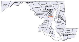
There are more than 1,500 properties and districts listed on the National Register of Historic Places in the U.S. State of Maryland. Each of the state's 23 counties and its one county-equivalent has at least 20 listings on the National Register.
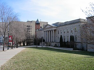
The Montgomery County Circuit Courthouses are part of the Montgomery County Judicial Center located in downtown Rockville, Maryland. The Red Brick Courthouse, located at 29 Courthouse Square, houses the refurbished Grand Courtroom; the newer Circuit Court building, located at 50 Maryland Avenue, houses the remainder of the county's justice system.

The Beall–Dawson House is a historic home located at Rockville, Montgomery County, Maryland, United States. It is a 2+1⁄2-story Federal house, three bays wide by two deep, constructed of Flemish bond brick on the front facade and common bond elsewhere. Outbuildings on the property include an original brick dairy house and a mid-19th century one-room Gothic Revival frame doctor's office which was moved to the site for use as a museum. The house was constructed in 1815.

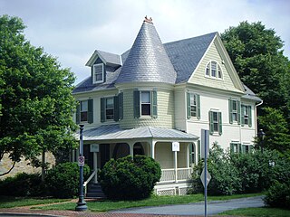
The Bingham-Brewer House is a historic home located at Rockville, Montgomery County, Maryland, United States. It is a two-story, Federal style brick house, with a Flemish Bond front facade, dating to 1821. Also on the property is a late-19th century smokehouse, privy, and a late-19th or early-20th century chicken house.

Dawson Farm, also known as "Rocky Glen," is a historic property with two homes located at Rockville, Montgomery County, Maryland. The property contains two dwellings: the 1874, 2+1⁄2-story, frame Dawson Farmhouse and a large 2+1⁄2-story hip-roofed frame house dating to 1912.
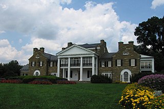
Glenview Mansion is a historic home and surrounding property located at Rockville, Montgomery County, Maryland. The house is a 1926 Neo-Classical Revival style house on 65 acres (260,000 m2) of landscaped ground. The five-part mansion incorporates the remnants of the 1838 house called "Glenview." Since 1957, the house and grounds have been owned by the City of Rockville, and are used for various civic, cultural and social events, and is known as Rockville Civic Center Park. The house also includes the Glenview Mansion Art Gallery.
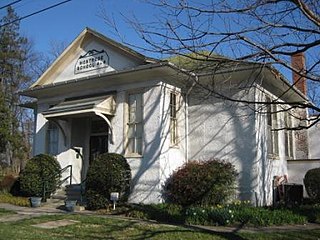
The Montrose School House is a historic school building located in Montgomery County, Maryland, in North Bethesda, south of the city of Rockville. It is a one-story, rectangular, hip-roofed building of frame construction with a pebble-dash finish. It is the best-preserved of the six functional school buildings constructed in Montgomery County around 1910.

Silver Spring station is a former train station on the Metropolitan Subdivision in Silver Spring in Montgomery County, Maryland. It was built in 1945 by the Baltimore and Ohio Railroad on the foundation of a previous station, a Victorian-style brick structure built in 1878. It served intercity trains until 1986 and light rail until 2000. Today, it is owned and operated as a museum by Montgomery Preservation, Inc., a non-profit organization.

The Garrett Park Historic District is a national historic district located at Garrett Park, Montgomery County, Maryland. It's a 154-acre (62 ha) residential community incorporated in 1891, along the B & O Railroad. The older community includes a number of late Victorian homes. During the 1920s, the town expanded with a set of 40,640-square-foot (3,776 m2), "Chevy" houses built by Maddux, Marshall & Co. The district also includes a set of Prairie Style homes designed and built by Alexander Richter during the 1950s.

The Third Addition to Rockville and Old St. Mary's Church and Cemetery is a historic area located in Rockville, Montgomery County, Maryland. This area combines 19th century residential scale buildings with a tree-lined narrow street, country church, weathered headstones, Victorian Gothic railroad station, and a brick cast-iron front commercial structure, to create an atmosphere that evokes the era when the station served as the gateway to Rockville. In addition to Victorian Gothic, architectural styles used in residential buildings include Queen Anne, Georgian, and Colonial Revival. The area was listed on the National Register of Historic Places in 1978.

The Takoma Park Historic District is a national historic district located at Takoma Park, Montgomery County, Maryland. The district area was platted in 1883 by developer Benjamin Franklin Gilbert, and promoted for its natural environment and healthy setting. Originally an early railroad suburb, the opening of streetcar lines led to the expansion of the district in the early 20th century. Takoma Park houses built between 1883 and 1900 are fanciful, turreted, multi-gabled affairs of Queen Anne architecture with Stick Style and Shingle Style influence. Buildings developed after the turn of the 20th century tend to be 1-2 story brick structures with simple ornamentation, although a few display characteristics of such styles as Art Deco and Tudor Revival.
The West Montgomery Avenue Historic District is a national historic district located at Rockville, Montgomery County, Maryland. It is a residential area with single-family homes predominating. The majority of the properties within the district date from the 1880s, with a few older homes and somewhat more from later periods. The predominant character of the district is set by the rows of Victorian houses built between 1880 and 1900 in a vernacular residential mode with Eastlake and Stick Style influences. Also included in the district are attorneys' offices; churches and parsonages; a funeral home; the former Woodlawn Hotel, later called the Chestnut Lodge Sanitarium ; and the headquarters of the Montgomery County Historical Society.

Seneca is an unincorporated community in Montgomery County, Maryland, United States. It is located near the intersection of River Road and Seneca Creek, not far from the Chesapeake and Ohio Canal and Potomac River. Its history goes back before the American Revolutionary War and it thrived when the canal was operating—having several warehouses, mills, a store, a hotel, and a school. Fighting occurred in the area on more than one occasion during the American Civil War. The community declined as the C&O Canal declined.

Riley's Lock (Lock 24) and lock house are part of the 184.5-mile (296.9 km) Chesapeake and Ohio Canal that operated in the United States along the Potomac River from the 1830s through 1923. They are located at towpath mile-marker 22.7 adjacent to Seneca Creek, in Montgomery County, Maryland. The lock is sometimes identified as Seneca because of the Seneca Aqueduct that carried the canal over the creek to the lift lock. The name Riley comes from John C. Riley, who was lock keeper from 1892 until the canal closed permanently in 1924.


