Current listings
| [3] | Name on the Register | Image | Date listed [4] | Location | District [5] | Description |
|---|---|---|---|---|---|---|
| 1 | Bagby Furniture Company Building |  | October 22, 1998 (#98001263) | 509 S. Exeter St. 39°17′05″N76°36′00″W / 39.284722°N 76.6°W | Southeast | |
| 2 | BALTIMORE (tug) |  | November 4, 1993 (#93001613) | 1415 Key Highway 39°16′28″N76°36′01″W / 39.274444°N 76.600278°W | South | |
| 3 | Baltimore and Ohio Locust Point Grain Terminal Elevator |  | December 23, 2004 (#04001379) | 1700 Beason St. 39°16′19″N76°35′20″W / 39.271944°N 76.588889°W | South | |
| 4 | Baltimore and Ohio Transportation Museum and Mount Clare Station |  | October 15, 1966 (#66000906) | Pratt and Poppleton Sts. 39°17′07″N76°37′57″W / 39.285278°N 76.6325°W | South | |
| 5 | BANCROFT (motor vessel) | March 27, 1980 (#80001780) | Fell's Point 39°16′54″N76°35′30″W / 39.281667°N 76.591667°W | Southeast | ||
| 6 | Bankard-Gunther Mansion |  | August 6, 1980 (#80001781) | 2102 E. Baltimore Street 39°17′31″N76°35′14″W / 39.291944°N 76.587222°W | Southeast | |
| 7 | Barre Circle Historic District |  | January 10, 1983 (#83002926) | Roughly bounded by Scott St., Ramsey St., Boyd St., and Harbor City Boulevard./S. Fremont St. 39°17′08″N76°37′43″W / 39.285556°N 76.628611°W | South | |
| 8 | Building at 239 North Gay Street |  | October 7, 1994 (#94001202) | 239 N. Gay St. 39°17′38″N76°36′29″W / 39.293889°N 76.608056°W | Southeast | SW corner of Gay and Front. Iron front, Italianate style. |
| 9 | Butchers Hill Historic District |  | December 28, 1982 (#82001582) | Roughly bounded by Patterson Park Ave. and Fayette, Pratt, Chapel, Washington, and Chester Sts. 39°17′29″N76°35′13″W / 39.291389°N 76.586944°W | Southeast | |
| 10 | Canton Historic District |  | January 29, 1980 (#80001784) | Eastern Ave. and Waterfront, Conklin, and Chester Sts. 39°16′53″N76°34′34″W / 39.281389°N 76.576111°W | Southeast | |
| 11 | Carroll Mansion |  | May 25, 1973 (#73002182) | 800 E. Lombard St. 39°17′19″N76°36′17″W / 39.288611°N 76.604722°W | Southeast | |
| 12 | Carrollton Viaduct |  | November 11, 1971 (#71001032) | Gwynn's Falls near Carroll Park 39°16′31″N76°39′19″W / 39.275278°N 76.655278°W | South | |
| 13 | Chizuk Amuno Synagogue |  | April 19, 1978 (#78003141) | 27–35 Lloyd St. 39°17′24″N76°36′04″W / 39.29°N 76.601111°W | Southeast | |
| 14 | Coca-Cola Baltimore Branch Factory |  | May 4, 2001 (#01000407) | 1215 E. Fort Ave. 39°16′07″N76°35′53″W / 39.268611°N 76.598056°W | South | |
| 15 | Douglass Place |  | September 15, 1983 (#83004214) | 516–524 S. Dallas St. 39°17′06″N76°35′47″W / 39.285°N 76.596389°W | Southeast | |
| 16 | Dorguth Memorial United Methodist Church |  | August 14, 1979 (#79003216) | Scott and Carroll St. 39°16′56″N76°37′44″W / 39.282222°N 76.628889°W | South | |
| 17 | Dundalk Historic District |  | December 8, 1983 (#83003630) | Roughly bounded by Liberty Parkway, Dunman, Willow Spring, and Sunship Rds., and Chesapeake and Patapsco Aves. 39°15′35″N76°31′26″W / 39.259722°N 76.523889°W | Southeast | |
| 18 | Eastern Female High School |  | September 10, 1971 (#71001035) | 249 Aisquith St. 39°17′40″N76°36′06″W / 39.294444°N 76.601667°W | Southeast | |
| 19 | Equitable Gas Works |  | December 29, 2003 (#03001322) | 1401 Severn St. 39°16′31″N76°37′56″W / 39.275278°N 76.632222°W | South | |
| 20 | Federal Hill Historic District |  | April 17, 1970 (#70000859) | Bounded by Baltimore Harbor and Hughes, Hanover, and Cross Sts. 39°16′44″N76°36′36″W / 39.278889°N 76.61°W | South | |
| 21 | Federal Hill South Historic District |  | December 22, 2003 (#03001331) | Roughly bounded by Cross St., Olive St., Marshall St., Ostend St., Fort Ave., and Covington St. 39°16′33″N76°36′39″W / 39.275833°N 76.610833°W | South | |
| 22 | Fells Point Historic District |  | March 28, 1969 (#69000319) | Bounded on the north by Aliceanna St., on the east by Wolfe St., on the south by Baltimore Harbor, and on the west by Dallas St. 39°16′59″N76°35′34″W / 39.283056°N 76.592778°W | Southeast | Includes later boundary increase. |
| 23 | Flag House |  | December 3, 1969 (#69000320) | 844 E. Pratt St. 39°17′15″N76°36′13″W / 39.2875°N 76.603611°W | Southeast | |
| 24 | Fort McHenry National Monument and Historic Shrine | 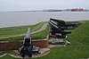 | October 15, 1966 (#66000907) | Locust Point, at the eastern end of Fort Ave. 39°15′49″N76°34′48″W / 39.263611°N 76.58°W | TBD | |
| 25 | Gay Street Historic District |  | November 21, 2003 (#03001173) | Bounded by N. Gay, Fallsway, Low and N. Exeter Sts. 39°17′35″N76°36′26″W / 39.293056°N 76.607222°W | Southeast | |
| 26 | Hendler Creamery | 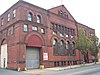 | December 20, 2007 (#07001032) | 1100 E. Baltimore St. and 1107 E. Fayette St. 39°17′28″N76°36′08″W / 39.291111°N 76.602222°W | Southeast | |
| 27 | Holy Cross Roman Catholic Church |  | December 30, 2002 (#02001578) | 106–112 E. West St. 39°16′34″N76°36′40″W / 39.276111°N 76.611111°W | South | |
| 28 | House at 9 North Front Street | 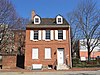 | June 14, 1979 (#79003217) | 9 N. Front St. 39°17′26″N76°36′19″W / 39.290556°N 76.605278°W | Southeast | |
| 29 | SS JOHN W. BROWN (Liberty Ship) |  | November 17, 1997 (#97001295) | Pier 1, Clinton St. 39°16′04″N76°34′12″W / 39.267778°N 76.57°W | Southeast | |
| 30 | Johns Hopkins Hospital Complex |  | February 24, 1975 (#75002094) | 601 N. Broadway 39°17′50″N76°35′37″W / 39.297222°N 76.593611°W | Southeast | |
| 31 | Leadenhall Street Baptist Church |  | March 16, 1979 (#79003218) | 1021–1023 Leadenhall St. 39°16′38″N76°37′03″W / 39.277222°N 76.6175°W | South | |
| 32 | Little Montgomery Street Historic District |  | April 15, 1982 (#82004748) | W. Montgomery and Leadenhall Sts. 39°16′48″N76°37′00″W / 39.28°N 76.616667°W | South | |
| 33 | Lloyd Street Synagogue |  | April 19, 1978 (#78003142) | 11 Lloyd St. 39°17′26″N76°36′05″W / 39.290556°N 76.601389°W | Southeast | A part of the Jewish Museum of Maryland. |
| 34 | Locust Point Historic District |  | December 26, 2012 (#12001084) | Roughly bounded by Fort Ave., B & O RR., Woodall & Reynolds Sts. 39°16′13″N76°35′35″W / 39.270404°N 76.593035°W | South | |
| 35 | Loft Historic District North |  | January 3, 1985 (#85000016) | Roughly bounded by Paca, Redwood, Eutaw, and Lombard Sts. 39°17′18″N76°37′19″W / 39.288333°N 76.621944°W | South | |
| 36 | Loft Historic District South |  | January 3, 1985 (#85000017) | Along the 500 block of W. Pratt St., bounded by Green St. and the 100 block of S. Paca St. 39°17′10″N76°37′23″W / 39.286111°N 76.623056°W | South | |
| 37 | Lord Baltimore Hotel | 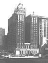 | December 2, 1982 (#82001587) | 20 West Baltimore St. 39°17′23″N76°36′58″W / 39.289722°N 76.616111°W | South | |
| 38 | Maryland White Lead Works |  | December 27, 2002 (#02001604) | 921–979 E. Fort Ave. 39°16′14″N76°36′04″W / 39.270643°N 76.601018°W | South | |
| 39 | McKim's School |  | March 30, 1973 (#73002190) | 1120 E. Baltimore St. 39°17′28″N76°36′04″W / 39.291111°N 76.601111°W | Southeast | McKim Community Center |
| 40 | H.L. Mencken House |  | July 28, 1983 (#83004384) | 1524 Hollins Rd. 39°17′15″N76°38′29″W / 39.2875°N 76.641389°W | South | |
| 41 | Montgomery Ward Warehouse and Retail Store |  | September 14, 2000 (#00001085) | 1000 S. Monroe St. 39°16′34″N76°38′41″W / 39.276111°N 76.644722°W | South | |
| 42 | Mount Auburn Cemetery |  | September 7, 2001 (#01000456) | 2614 Annapolis Rd. 39°15′34″N76°38′23″W / 39.259444°N 76.639722°W | South | |
| 43 | Mount Clare |  | April 15, 1970 (#70000860) | Carroll Park 39°16′44″N76°38′37″W / 39.278889°N 76.643611°W | South | |
| 44 | National Brewing Company |  | December 30, 2002 (#02001579) | 3601–3901 Dillon St. 39°16′51″N76°33′53″W / 39.280833°N 76.564722°W | Southeast | |
| 45 | National Enameling and Stamping Company |  | December 27, 2002 (#02001583) | 1901 Light St. 39°16′04″N76°36′38″W / 39.267778°N 76.610556°W | South | |
| 46 | Old Town Friends' Meetinghouse |  | March 30, 1973 (#73002192) | 1201 E. Fayette St. 39°17′31″N76°36′04″W / 39.291944°N 76.601111°W | Southeast | |
| 47 | Parker Metal Decoration Company Plant |  | November 22, 2000 (#00001391) | 333 W. Ostend St. 39°16′31″N76°37′18″W / 39.275278°N 76.621667°W | South | |
| 48 | Patterson Park-Highlandtown Historic District |  | December 27, 2002 (#02001623) | Roughly bounded by Patterson Park Ave., E. Fayette St., and Pulaski Highway, Grundy St., Eastern Ave., Patterson Park 39°17′30″N76°34′23″W / 39.291667°N 76.573056°W | Southeast | |
| 49 | Pigtown Historic District | 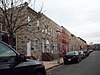 | December 28, 2006 (#06001177) | Roughly bounded by McHenry St. and Ramsay St., W. Barre, S. Paca, Ostend and Wicomico Sts., Bush and Bayard Sts, and the railroad line 39°16′49″N76°37′56″W / 39.280278°N 76.632222°W | South | |
| 50 | Polish Home Hall |  | December 26, 2007 (#07001311) | 4416 Fairhaven Ave. 39°13′31″N76°35′25″W / 39.225278°N 76.590278°W | South | |
| 51 | Poppleton Fire Station |  | September 8, 1983 (#83002938) | 756–760 W. Baltimore St. 39°17′20″N76°37′44″W / 39.288889°N 76.628889°W | South | |
| 52 | Procter and Gamble Baltimore Plant | 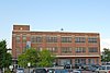 | October 28, 1999 (#99001280) | 1422 Nicholson St. 39°16′30″N76°35′30″W / 39.275°N 76.591667°W | South | |
| 53 | Public School No. 25 | 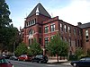 | September 25, 1979 (#79001111) | S. Bond St. 39°17′06″N76°35′43″W / 39.285°N 76.595278°W | Southeast | |
| 54 | Ridgely's Delight Historic District | 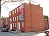 | June 6, 1980 (#80001790) | Roughly bounded by S. Fremont Ave. and W. Pratt, Conway, and Russell Sts. 39°17′08″N76°37′31″W / 39.285556°N 76.625278°W | South | |
| 55 | Riverside Historic District |  | April 30, 2008 (#08000358) | Bounded by Race St. from the west, south to Winder, east to Webster, north to Heath, east to Boyle and north to Fort, then west to Marshall 39°16′13″N76°36′33″W / 39.270253°N 76.609264°W | South | |
| 56 | Rombro Building |  | May 26, 2005 (#94001172) | 22–24 S. Howard St. 39°17′18″N76°37′12″W / 39.288333°N 76.62°W | South | |
| 57 | St. Alphonsus' Church, Rectory, Convent and Halle |  | May 23, 1973 (#73002195) | 112–116, 125–127 W. Saratoga St. 39°17′35″N76°37′04″W / 39.293056°N 76.617778°W | Southeast | |
| 58 | St. Brigid's School and Convent | December 27, 2016 (#16000909) | 900 S. East Ave. 39°16′56″N76°34′17″W / 39.282222°N 76.571329°W | |||
| 59 | St. Elizabeth of Hungary |  | November 4, 1994 (#94001278) | Junction of E. Baltimore St. and Lakewood Ave. 39°17′33″N76°34′45″W / 39.2925°N 76.579167°W | Southeast | |
| 60 | St. Leo's Church |  | July 28, 1983 (#83002939) | 221 S. Exeter St. 39°17′15″N76°36′03″W / 39.2875°N 76.600833°W | Southeast | |
| 61 | St. Michael's Church Complex | 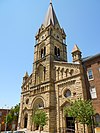 | May 17, 1989 (#89000383) | 1900–1920 E. Lombard St. 39°17′26″N76°35′24″W / 39.290556°N 76.59°W | Southeast | |
| 62 | St. Paul's Cemetery | 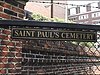 | June 30, 1988 (#88000746) | Redwood St. and Martin Luther King Boulevard 39°17′15″N76°37′41″W / 39.2875°N 76.628056°W | South | |
| 63 | St. Peter the Apostle Church and Buildings |  | October 14, 1976 (#76002184) | 11 and 13 S. Poppleton St. and 848 Hollins St. 39°17′17″N76°37′56″W / 39.288056°N 76.632222°W | South | |
| 64 | St. Vincent De Paul Roman Catholic Church |  | February 12, 1974 (#74002215) | 120 N. Front St. 39°17′29″N76°36′24″W / 39.291389°N 76.606667°W | Southeast | |
| 65 | SAVANNAH (nuclear ship) |  | November 14, 1982 (#82001518) | Patapsco River, Port of Baltimore 39°15′31″N76°33′20″W / 39.258611°N 76.555556°W | South | Previously in York County, Virginia |
| 66 | Shot Tower |  | October 1, 1969 (#69000373) | Southeastern corner of Fayette and Front Sts. 39°17′26″N76°36′20″W / 39.290556°N 76.605556°W | Southeast | Also known as Phoenix Shot Tower. |
| 67 | School No. 27 (Commodore John Rodgers Elementary School) | March 21, 1986 (#86000613) | 2031 E. Fayette St. 39°17′38″N76°35′16″W / 39.293889°N 76.587778°W | Southeast | ||
| 68 | Sonneborn Building |  | October 29, 1982 (#82001588) | 110 S. Paca St. 39°17′11″N76°37′21″W / 39.286389°N 76.6225°W | South | |
| 69 | South Central Avenue Historic District |  | November 11, 2001 (#01001213) | Approximately 8 blocks centering on Central Ave. between Pratt and Fleet Sts. 39°17′12″N76°35′58″W / 39.286667°N 76.599444°W | Southeast | |
| 70 | Southern District Police Station |  | December 28, 2001 (#01001373) | 28 E. Ostend St. 39°16′30″N76°36′47″W / 39.275°N 76.613056°W | South | |
| 71 | Turner-White Casket Co. Building |  | January 26, 1995 (#94001553) | 509–511 W. Lombard St. 39°17′14″N76°37′21″W / 39.287222°N 76.6225°W | South | |
| 72 | U.S. Post Office and Courthouse |  | March 25, 1977 (#77001530) | 111 N. Calvert St. 39°17′27″N76°36′44″W / 39.290833°N 76.612222°W | South | |
| 73 | Union Bros. Furniture Company | February 7, 2018 (#100001959) | 1120 S Hanover St. 39°16′34″N76°36′57″W / 39.276117°N 76.615727°W | |||
| 74 | Union Square-Hollins Market Historic District |  | September 15, 1983 (#83002941) | Roughly bounded by Fulton, Fayette, Pratt, and Schroeder Sts. 39°17′13″N76°38′25″W / 39.286944°N 76.640278°W | South | See Union Square and Hollins Market |
| 75 | WHEC-37 |  | June 7, 1988 (#88001826) | Pier 6 39°17′09″N76°36′23″W / 39.285833°N 76.606389°W | South | |
| 76 | Walters Bath No. 2 |  | June 19, 1979 (#79003220) | 900 Washington Boulevard 39°16′59″N76°37′52″W / 39.283056°N 76.631111°W | South | |
| 77 | Wilkens-Robins Building | 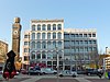 | December 3, 1980 (#80001792) | 308–312 W. Pratt St. 39°17′11″N76°37′12″W / 39.286389°N 76.62°W | South |