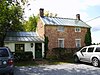
[3] Name on the Register [4] Image Date listed [5] Location City or town Description 1 Airview Historic District Airview Historic District December 29, 2004 (# 04001404 701-720 E. Main St. extended 39°26′26″N 77°31′46″W / 39.4406°N 77.5294°W / 39.4406; -77.5294 (Airview Historic District ) Middletown 2 Amelung House and Glassworks Amelung House and Glassworks October 3, 1973 (# 73000919 2531 Park Mills Road 39°18′02″N 77°24′11″W / 39.3006°N 77.4031°W / 39.3006; -77.4031 (Amelung House and Glassworks ) Urbana 3 Arcadia Arcadia August 3, 1978 (# 78001458 4720 Buckeystown Pike Maryland Route 85 39°21′51″N 77°25′08″W / 39.3642°N 77.4189°W / 39.3642; -77.4189 (Arcadia ) Frederick 4 Beatty-Cramer House Beatty-Cramer House August 17, 2021 (# 100006825 9010 Liberty Road 39°27′12″N 77°21′14″W / 39.4533°N 77.3540°W / 39.4533; -77.3540 (Beatty-Cramer House ) Frederick vicinity 5 Bennies Hill Road Bridge Bennies Hill Road Bridge June 27, 1979 (# 79003265 Southwest of Middletown on Bennies Hill Rd. over Catoctin Creek 39°24′34″N 77°34′12″W / 39.4094°N 77.57°W / 39.4094; -77.57 (Bennies Hill Road Bridge ) Middletown 6 Biggs Ford Site Upload image June 10, 1975 (# 75000894 Address Restricted Frederick 7 Bloomsbury Upload image September 13, 2000 (# 00001053 2062 Thurston Rd. 39°18′23″N 77°22′09″W / 39.3064°N 77.3692°W / 39.3064; -77.3692 (Bloomsbury ) Frederick 8 Bowlus Mill House Bowlus Mill House March 26, 1996 (# 96000300 8123 Old Hagerstown Rd. 39°27′20″N 77°33′35″W / 39.4556°N 77.5596°W / 39.4556; -77.5596 (Bowlus Mill House ) Spoolsville 9 Henry Brandenburg House Upload image December 11, 2020 (# 100005908 9057 Myersville Rd. 39°28′57″N 77°32′38″W / 39.4826°N 77.5438°W / 39.4826; -77.5438 (Henry Brandenburg House ) Myersville vicinity 10 Brunswick Historic District Brunswick Historic District August 29, 1979 (# 79001128 Roughly bounded by the Potomac River , Central, Park, and 10th Aves., and C St. 39°18′41″N 77°37′30″W / 39.3114°N 77.625°W / 39.3114; -77.625 (Brunswick Historic District ) Brunswick 11 Buckeystown Historic District Buckeystown Historic District April 6, 1982 (# 82002811 Maryland Route 85 39°19′53″N 77°26′04″W / 39.3314°N 77.4344°W / 39.3314; -77.4344 (Buckeystown Historic District ) Buckeystown 12 Buckingham House and Industrial School Complex Buckingham House and Industrial School Complex May 20, 1982 (# 82002812 Off Maryland Routes 80 and 85 39°18′52″N 77°25′26″W / 39.3144°N 77.4239°W / 39.3144; -77.4239 (Buckingham House and Industrial School Complex ) Buckeystown 13 Bullfrog Road Bridge Bullfrog Road Bridge November 21, 1978 (# 78001461 Northwest of Taneytown off Maryland Route 97 39°41′44″N 77°14′25″W / 39.6956°N 77.2403°W / 39.6956; -77.2403 (Bullfrog Road Bridge ) Taneytown 14 Burkittsville Historic District Burkittsville Historic District November 20, 1975 (# 75000891 Maryland Route 17 and Jefferson-Boonsboro Rd. 39°23′31″N 77°37′39″W / 39.3919°N 77.6275°W / 39.3919; -77.6275 (Burkittsville Historic District ) Burkittsville 15 Camp Greentop Historic District Camp Greentop Historic District October 11, 1989 (# 89001583 Off Park Central Rd. in Catoctin Mountain Park 39°38′39″N 77°28′35″W / 39.6442°N 77.4764°W / 39.6442; -77.4764 (Camp Greentop Historic District ) Thurmont 16 Camp Misty Mount Historic District Camp Misty Mount Historic District October 11, 1989 (# 89001582 Off Park Central Rd. in Catoctin Mountain Park 39°38′31″N 77°26′55″W / 39.6419°N 77.4486°W / 39.6419; -77.4486 (Camp Misty Mount Historic District ) Thurmont 17 Carrollton Manor Carrollton Manor November 17, 1997 (# 97001294 5809 Manor Woods Rd. 39°19′28″N 77°28′12″W / 39.3244°N 77.47°W / 39.3244; -77.47 (Carrollton Manor ) Buckeystown 18 Catoctin Furnace Historic District Catoctin Furnace Historic District February 11, 1972 (# 72000578 Eastern side of U.S. Route 15 39°34′35″N 77°26′02″W / 39.5764°N 77.4339°W / 39.5764; -77.4339 (Catoctin Furnace Historic District ) Catoctin Furnace 19 Catoctin Mountain Park Catoctin Mountain Park August 7, 2014 (# 14000484 6602 Foxville Rd. 39°38′54″N 77°28′00″W / 39.6483°N 77.4667°W / 39.6483; -77.4667 (Catoctin Mountain Park ) Thurmont 20 Ceres Bethel AME Church Ceres Bethel AME Church December 22, 2020 (# 100005982 Gapland Rd., approx. 2 mi. west of Burkittsville 39°24′06″N 77°38′16″W / 39.4016°N 77.6377°W / 39.4016; -77.6377 (Ceres Bethel AME Church ) Burkittsville 21 Chesapeake and Ohio Canal National Historical Park Chesapeake and Ohio Canal National Historical Park October 15, 1966 (# 66000036 Bordering the Potomac River from Georgetown, D.C. to Cumberland, Maryland 38°53′59″N 77°03′28″W / 38.8997°N 77.0578°W / 38.8997; -77.0578 (Chesapeake and Ohio Canal National Historical Park ) Brunswick , Point of Rocks 22 Cockey-Jamison-Hendrickson House and Store Cockey-Jamison-Hendrickson House and Store November 28, 2018 (# 100003151 3409 Urbana Pike 39°19′34″N 77°20′56″W / 39.3260°N 77.3490°W / 39.3260; -77.3490 (Cockey-Jamison-Hendrickson House and Store ) Urbana 23 Crampton's Gap Historic District Crampton's Gap Historic District January 12, 2011 (# 10000576 Route 17; Gapland Rd.; Mountain Church Rd.; Brownsville Pass Rd.; Townsend Rd. 39°24′21″N 77°38′24″W / 39.4058°N 77.64°W / 39.4058; -77.64 (Crampton's Gap Historic District ) Burkittsville South Mountain Battlefields—September 14, 1862, MPS 24 Crum Road Bridge Crum Road Bridge December 28, 1978 (# 78001463 East of Walkersville at Crum Rd. and Israel's Creek 39°28′47″N 77°19′39″W / 39.4797°N 77.3275°W / 39.4797; -77.3275 (Crum Road Bridge ) Walkersville 25 Victor Cullen Center, Old Administration Building Victor Cullen Center, Old Administration Building August 22, 1990 (# 90001228 Victor Cullen Center Campus 39°42′40″N 77°27′26″W / 39.7111°N 77.4572°W / 39.7111; -77.4572 (Victor Cullen Center, Old Administration Building ) Sabillasville 26 Victor Cullen School Power House Victor Cullen School Power House January 7, 1987 (# 87000045 Maryland Route 81 39°42′52″N 77°27′43″W / 39.7144°N 77.4619°W / 39.7144; -77.4619 (Victor Cullen School Power House ) Sabillasville 27 Drummine Farm Drummine Farm January 8, 1987 (# 86003543 6901 Green Valley Rd. 39°25′39″N 77°14′43″W / 39.4275°N 77.2453°W / 39.4275; -77.2453 (Drummine Farm ) New Market 28 Emmitsburg Historic District Emmitsburg Historic District March 10, 1992 (# 92000076 Roughly, Main St. east of Mountain View Cemetery to Creamery Rd. and Seton Ave. adjacent to Main; also a portion of the south side of the 400 block of West Lincoln Avenue, from Patterson Avenue, 375’ west, to the west property line of 439 West Lincoln Avenue 39°42′16″N 77°19′40″W / 39.7044°N 77.3278°W / 39.7044; -77.3278 (Emmitsburg Historic District ) Emmitsburg Second set of addresses represent a boundary increase approved April 8, 2024 . 29 John Eyler Farmstead John Eyler Farmstead September 13, 2006 (# 06000817 7216 Eylers Valley Flint Rd. 39°40′40″N 77°25′01″W / 39.6778°N 77.4169°W / 39.6778; -77.4169 (John Eyler Farmstead ) Thurmont 30 Fat Oxen Fat Oxen May 21, 1979 (# 79001133 North of Urbana on Maryland Route 355 39°20′00″N 77°21′23″W / 39.3333°N 77.3564°W / 39.3333; -77.3564 (Fat Oxen ) Urbana 31 Fourpoints Bridge Fourpoints Bridge November 29, 1978 (# 78001457 Southeast of Emmitsburg 39°40′17″N 77°18′04″W / 39.6714°N 77.3011°W / 39.6714; -77.3011 (Fourpoints Bridge ) Emmitsburg 32 Frederick Armory Frederick Armory September 25, 1985 (# 85002672 Bentz and 2nd Sts. 39°25′00″N 77°24′53″W / 39.4167°N 77.4147°W / 39.4167; -77.4147 (Frederick Armory ) Frederick 33 Frederick Historic District Frederick Historic District October 18, 1973 (# 73000916 2 blocks east and 3 blocks west of Market St., from South St. to 7th St. 39°24′53″N 77°24′43″W / 39.4147°N 77.4119°W / 39.4147; -77.4119 (Frederick Historic District ) Frederick 34 Gambrill House Gambrill House November 18, 1985 (# 85002902 Monocacy National Battlefield off Maryland Route 355 38°21′56″N 77°23′11″W / 38.3656°N 77.3864°W / 38.3656; -77.3864 (Gambrill House ) Frederick 35 Graceham Moravian Church and Parsonage Graceham Moravian Church and Parsonage May 13, 1976 (# 76000995 2 miles east of Thurmont on Maryland Route 77 39°36′59″N 77°22′43″W / 39.6164°N 77.3786°W / 39.6164; -77.3786 (Graceham Moravian Church and Parsonage ) Thurmont 36 Peter of P. Grossnickel Farm Peter of P. Grossnickel Farm July 31, 1998 (# 98000944 11720 Wolfsville Rd. 39°33′25″N 77°31′38″W / 39.5569°N 77.5272°W / 39.5569; -77.5272 (Peter of P. Grossnickel Farm ) Myersville 37 Guilford Guilford October 14, 1975 (# 75000895 5900 Frederick Crossing Lane 38°23′43″N 77°24′51″W / 38.3954°N 77.4141°W / 38.3954; -77.4141 (Guilford ) Frederick 38 Harris Farm Harris Farm July 29, 1994 (# 94000799 Junction of Devilbiss and Glade Rds. 39°29′55″N 77°20′57″W / 39.4986°N 77.3492°W / 39.4986; -77.3492 (Harris Farm ) Walkersville 39 Hessian Barracks Hessian Barracks January 25, 1971 (# 71000373 242 S. Market St. 39°24′33″N 77°24′34″W / 39.409028°N 77.409389°W / 39.409028; -77.409389 (Hessian Barracks ) Frederick 40 Highland Lodge Highland Lodge October 22, 1998 (# 98001262 5519 Old National Pike 39°25′11″N 77°28′31″W / 39.4197°N 77.4753°W / 39.4197; -77.4753 (Highland Lodge ) Frederick 41 Hood College Historic District Hood College Historic District December 30, 2002 (# 02001581 401 Rosemont Ave. 39°25′21″N 77°25′07″W / 39.4225°N 77.4186°W / 39.4225; -77.4186 (Hood College Historic District ) Frederick 42 Hopewell Hopewell December 8, 1980 (# 80001803 Pearre and Clemsonville Rds. 39°31′32″N 77°10′13″W / 39.5255°N 77.1702°W / 39.5255; -77.1702 (Hopewell ) Union Bridge 43 Abraham Jones House Abraham Jones House July 24, 1973 (# 73000917 12106 Main Street (MD 26) 39°29′07″N 77°14′24″W / 39.485278°N 77.24°W / 39.485278; -77.24 (Abraham Jones House ) Libertytown 44 Kitterman-Buckey Farm Upload image December 28, 2005 (# 05001479 12529 Molasses Rd. 39°31′50″N 77°13′31″W / 39.530556°N 77.225278°W / 39.530556; -77.225278 (Kitterman-Buckey Farm ) Johnsville 45 L'Hermitage Slave Village Archeological Site L'Hermitage Slave Village Archeological Site January 29, 2008 (# 07001450 4801 Urbana Pike 39°21′58″N 77°23′25″W / 39.366231°N 77.3902545°W / 39.366231; -77.3902545 (L'Hermitage Slave Village Archeological Site ) Frederick 46 LeGore Bridge LeGore Bridge September 18, 1978 (# 78001464 North of Woodsboro over the Monocacy River 39°34′50″N 77°18′50″W / 39.580556°N 77.313889°W / 39.580556; -77.313889 (LeGore Bridge ) Woodsboro 47 Lewis Mill Complex Lewis Mill Complex May 6, 1982 (# 82002813 3205 Poffenberger Rd. 39°22′20″N 77°33′34″W / 39.372222°N 77.559444°W / 39.372222; -77.559444 (Lewis Mill Complex ) Jefferson 48 Linden Grove Linden Grove September 10, 1987 (# 87001570 636 Solarex Court 39°24′02″N 77°26′01″W / 39.400556°N 77.433611°W / 39.400556; -77.433611 (Linden Grove ) Frederick 49 Linganore Farm Linganore Farm May 5, 2000 (# 00000429 6229 Linganore Rd. 39°24′21″N 77°21′42″W / 39.405833°N 77.361667°W / 39.405833; -77.361667 (Linganore Farm ) Frederick 50 Loats Female Orphan Asylum of Frederick City Loats Female Orphan Asylum of Frederick City October 10, 1972 (# 72000580 24 E. Church St. 39°24′54″N 77°24′34″W / 39.415°N 77.409444°W / 39.415; -77.409444 (Loats Female Orphan Asylum of Frederick City ) Frederick 51 Loys Station Covered Bridge Loys Station Covered Bridge June 23, 1978 (# 78003175 Old Frederick Rd. at Owen's Creek 39°36′26″N 77°21′08″W / 39.607222°N 77.352222°W / 39.607222; -77.352222 (Loys Station Covered Bridge ) Thurmont 52 George Markell Farmstead George Markell Farmstead December 27, 2002 (# 02001584 4825 Buckeystown Pike 39°21′58″N 77°24′54″W / 39.366111°N 77.415°W / 39.366111; -77.415 (George Markell Farmstead ) Frederick 53 Mason and Dixon West Line Milestone Markers 76 and 77 Upload image August 21, 2018 (# 100002789 716 Mason Dixon Rd. 39°43′12″N 77°13′15″W / 39.720000°N 77.220833°W / 39.720000; -77.220833 (Mason and Dixon West Line Milestone Markers 76 and 77 ) Harney Extends into Adams County, Pennsylvania 54 Thomas Maynard House Thomas Maynard House July 18, 1979 (# 79001130 11022 Gas House Pike 39°25′42″N 77°16′54″W / 39.428333°N 77.281667°W / 39.428333; -77.281667 (Thomas Maynard House ) New London 55 McKinstry's Mills Historic District McKinstry's Mills Historic District April 16, 1997 (# 97000338 1494, 1498, and 10904 McKinstry's Mill Rd. and 4500 and 4504 Sam's Creek Rd. 39°32′00″N 77°09′32″W / 39.533333°N 77.15889°W / 39.533333; -77.15889 (McKinstry's Mills Historic District ) Union Bridge 56 Middletown Historic District Middletown Historic District December 24, 2003 (# 03001334 Including E. and W. Main St., Green St., Washington St., Jefferson St., Church St., and Walnut St. 39°26′41″N 77°32′38″W / 39.444722°N 77.543889°W / 39.444722; -77.543889 (Middletown Historic District ) Middletown 57 Monocacy National Battlefield Monocacy National Battlefield November 8, 1973 (# 66000908 Southeast of Frederick 39°22′11″N 77°23′29″W / 39.369722°N 77.391389°W / 39.369722; -77.391389 (Monocacy National Battlefield ) Frederick 58 Monocacy Site Monocacy Site July 30, 1975 (# 75000151 Address Restricted Dickerson 59 John C. Motter House John C. Motter House December 2, 1982 (# 82001592 1005 Motter Ave. 39°25′38″N 77°24′38″W / 39.427222°N 77.410556°W / 39.427222; -77.410556 (John C. Motter House ) Frederick 60 Mount Airy Historic District Mount Airy Historic District September 13, 1984 (# 84001589 Roughly Main, Church, Maple, Park, Hill, and Warfield Sts. 39°22′31″N 77°09′21″W / 39.375278°N 77.155833°W / 39.375278; -77.155833 (Mount Airy Historic District ) Mount Airy 61 Nallin Farm House Nallin Farm House May 23, 1974 (# 74000951 Fort Detrick 39°26′52″N 77°24′51″W / 39.447778°N 77.414167°W / 39.447778; -77.414167 (Nallin Farm House ) Frederick 62 Nallin Farm Springhouse and Bank Barn Nallin Farm Springhouse and Bank Barn September 16, 1977 (# 77000695 Opossumtown Pike 39°26′50″N 77°24′54″W / 39.447222°N 77.415°W / 39.447222; -77.415 (Nallin Farm Springhouse and Bank Barn ) Frederick 63 Henry Nelson House Upload image December 4, 1980 (# 80001811 10822 Gas House Pike 39°25′59″N 77°17′14″W / 39.433056°N 77.287222°W / 39.433056; -77.287222 (Henry Nelson House ) New Market 64 New Market Historic District New Market Historic District December 6, 1975 (# 75000897 Junction of Maryland Route 144 and Old Maryland Route 75 39°22′58″N 77°16′12″W / 39.382778°N 77.27°W / 39.382778; -77.27 (New Market Historic District ) New Market 65 Nolands Ferry I Archeological Site Nolands Ferry I Archeological Site October 18, 1985 (# 85003152 Address Restricted Tuscarora 66 Oakland Oakland April 17, 2019 (# 100003656 1902 Jefferson Pike 39°20′56″N 77°36′14″W / 39.3489°N 77.6039°W / 39.3489; -77.6039 (Oakland ) Petersville 67 Old Mill Road Bridge Old Mill Road Bridge March 7, 1979 (# 79001131 West of Rocky Ridge on Old Mill Rd. over Owens Creek 39°36′07″N 77°20′19″W / 39.601944°N 77.338611°W / 39.601944; -77.338611 (Old Mill Road Bridge ) Rocky Ridge 68 Old National Pike Milestones Old National Pike Milestones November 27, 1975 (# 75002107 U.S. Route 40 , Alternate U.S. Route 40, and Scenic U.S. Route 40, and Maryland Routes 44 and 165 39°25′13″N 77°16′01″W / 39.420278°N 77.266944°W / 39.420278; -77.266944 (Old National Pike Milestones ) Frederick 69 One-Million-Liter Test Sphere One-Million-Liter Test Sphere November 23, 1977 (# 77000696 North of Frederick on Fort Detrick 39°26′03″N 77°25′45″W / 39.434167°N 77.429167°W / 39.434167; -77.429167 (One-Million-Liter Test Sphere ) Frederick 70 Pearre-Metcalfe House Upload image July 2, 1979 (# 79001132 9084 Albaugh Road 39°28′58″N 77°09′57″W / 39.482778°N 77.165833°W / 39.482778; -77.165833 (Pearre-Metcalfe House ) New Windsor 71 Pennterra Pennterra January 30, 1976 (# 76000992 12003 Penterra Manor Lane (MD 814) 39°33′59″N 77°20′41″W / 39.566389°N 77.344722°W / 39.566389; -77.344722 (Pennterra ) Creagerstown 72 Poffenberger Road Bridge Poffenberger Road Bridge November 29, 1978 (# 78001459 South of Middletown 39°22′54″N 77°34′18″W / 39.381667°N 77.571667°W / 39.381667; -77.571667 (Poffenberger Road Bridge ) Middletown 73 Point of Rocks Railroad Station Point of Rocks Railroad Station April 11, 1973 (# 73000918 On U.S. Route 15 39°16′24″N 77°32′00″W / 39.273333°N 77.533333°W / 39.273333; -77.533333 (Point of Rocks Railroad Station ) Point of Rocks Gothic Revival -style station built 1873 74 Prospect Hall Prospect Hall September 8, 1980 (# 80001810 Southwest of Frederick on Butterfly Lane 39°18′51″N 77°26′15″W / 39.314167°N 77.4375°W / 39.314167; -77.4375 (Prospect Hall ) Frederick 75 Rich Mountain Rich Mountain December 28, 2005 (# 05001480 6434 S. Clifton Rd. 39°24′40″N 77°30′15″W / 39.41111°N 77.50403°W / 39.41111; -77.50403 (Rich Mountain ) Frederick 76 Roddy Road Covered Bridge Roddy Road Covered Bridge June 23, 1978 (# 78003176 Roddy Rd. at Owen's Creek 39°38′26″N 77°23′39″W / 39.640556°N 77.394167°W / 39.640556; -77.394167 (Roddy Road Covered Bridge ) Thurmont 77 Rose Hill Manor Rose Hill Manor December 9, 1971 (# 71000374 1611 N. Market St. 39°26′11″N 77°24′21″W / 39.436389°N 77.405833°W / 39.436389; -77.405833 (Rose Hill Manor ) Frederick 78 Rosenstock Village Site Upload image April 16, 2018 (# 100002308 Address Restricted Frederick 79 Routzahn-Miller Farmstead Routzahn-Miller Farmstead September 27, 2006 (# 06000878 9117 Frostown Rd. 39°29′09″N 77°35′28″W / 39.485833°N 77.591111°W / 39.485833; -77.591111 (Routzahn-Miller Farmstead ) Middletown 80 St. Euphemia's School and Sisters' House St. Euphemia's School and Sisters' House September 13, 1984 (# 84001770 5052 DePaul St. 39°42′19″N 77°19′31″W / 39.705278°N 77.325278°W / 39.705278; -77.325278 (St. Euphemia's School and Sisters' House ) Emmitsburg 81 St. John's Church at Creagerstown Historic District St. John's Church at Creagerstown Historic District August 28, 2007 (# 07000862 8619 Blacks Mill Rd. 39°34′35″N 77°21′49″W / 39.576389°N 77.363611°W / 39.576389; -77.363611 (St. John's Church at Creagerstown Historic District ) Thurmont 82 St. Joseph's College and Mother Seton Shrine St. Joseph's College and Mother Seton Shrine January 1, 1976 (# 76000994 Maryland Route 806 39°41′40″N 77°19′19″W / 39.694444°N 77.321944°W / 39.694444; -77.321944 (St. Joseph's College and Mother Seton Shrine ) Emmitsburg 83 St. Paul's Episcopal Church St. Paul's Episcopal Church January 31, 1978 (# 78001460 North of Point of Rocks off U.S. Route 15 39°17′13″N 77°31′46″W / 39.286944°N 77.529444°W / 39.286944; -77.529444 (St. Paul's Episcopal Church ) Point of Rocks 84 Saleaudo Upload image September 24, 1979 (# 79003258 1242 New Design Road 39°16′07″N 77°28′37″W / 39.268611°N 77.476944°W / 39.268611; -77.476944 (Saleaudo ) Adamstown 85 Schifferstadt Schifferstadt July 22, 1974 (# 74000952 W. 2nd and Rosemont Sts. 39°25′24″N 77°25′39″W / 39.423333°N 77.4275°W / 39.423333; -77.4275 (Schifferstadt ) Frederick 86 Shafer's Mill Shafer's Mill June 26, 1986 (# 86001372 3018 Bennies Hill Rd. 39°24′40″N 77°33′54″W / 39.411111°N 77.565°W / 39.411111; -77.565 (Shafer's Mill ) Middletown 87 Daniel Sheffer Farm Upload image December 28, 2001 (# 01001375 8924A Mt. Tabor Rd. 39°28′39″N 77°35′43″W / 39.4775°N 77.595278°W / 39.4775; -77.595278 (Daniel Sheffer Farm ) Middletown 88 Shoemaker III Village Site Shoemaker III Village Site September 5, 1975 (# 75000893 Address Restricted Emmitsburg 89 Henry Shoemaker Farmhouse Henry Shoemaker Farmhouse May 11, 1989 (# 89000416 2136 Old National Pike 39°28′05″N 77°35′41″W / 39.468056°N 77.594722°W / 39.468056; -77.594722 (Henry Shoemaker Farmhouse ) Middletown 90 Henry Smeltzer Farmstead Upload image October 14, 2010 (# 10000830 3231 Bidle Rd. 39°26′14″N 77°33′19″W / 39.437222°N 77.555278°W / 39.437222; -77.555278 (Henry Smeltzer Farmstead ) Middletown 91 Spring Bank Spring Bank September 7, 1984 (# 84001772 7945 Worman's Mill Rd. 39°27′11″N 77°23′53″W / 39.453056°N 77.398056°W / 39.453056; -77.398056 (Spring Bank ) Frederick 92 Stancioff House Stancioff House April 23, 1975 (# 75000896 Junction of Maryland Routes 80 and 355 39°19′39″N 77°21′06″W / 39.3275°N 77.351667°W / 39.3275; -77.351667 (Stancioff House ) Urbana 93 Stonebraker and Harbaugh-Shafer Building Stonebraker and Harbaugh-Shafer Building December 27, 2002 (# 02001585 100-104 W. Main St. 38°26′38″N 77°32′49″W / 38.44376°N 77.54697°W / 38.44376; -77.54697 (Stonebraker and Harbaugh-Shafer Building ) Middletown 94 Strawberry Hill Strawberry Hill January 30, 1976 (# 76000993 Southeast of Creagerstown off Maryland Route 550 39°34′16″N 77°21′14″W / 39.571111°N 77.353889°W / 39.571111; -77.353889 (Strawberry Hill ) Creagerstown 95 Tipahato Tipahato July 19, 2001 (# 01000744 17130 Raven Rock Rd. 39°42′11″N 77°29′11″W / 39.70293°N 77.48629°W / 39.70293; -77.48629 (Tipahato ) Cascade 96 Turner's and Fox's Gaps Historic District Turner's and Fox's Gaps Historic District January 12, 2011 (# 10000575 U.S. 40-A and Reno Monument, Dahlgren, Frostown, Mt. Tabor, and Moser Rds. 39°29′02″N 77°37′06″W / 39.483889°N 77.618333°W / 39.483889; -77.618333 (Turner's and Fox's Gaps Historic District ) Middletown South Mountain Battlefields—September 14, 1862, MPS 97 Utica Covered Bridge Utica Covered Bridge June 23, 1978 (# 78003174 Utica Rd. at Fishing Creek 39°31′28″N 77°23′46″W / 39.524444°N 77.396111°W / 39.524444; -77.396111 (Utica Covered Bridge ) Thurmont 98 George Widrick House George Widrick House September 12, 1985 (# 85002172 Ballenger Creek Park 39°22′58″N 77°27′07″W / 39.382778°N 77.451944°W / 39.382778; -77.451944 (George Widrick House ) Frederick 99 George Willard House George Willard House July 22, 1993 (# 93000665 4804 Old Middletown Rd. 39°21′54″N 77°32′23″W / 39.365°N 77.539722°W / 39.365; -77.539722 (George Willard House ) Jefferson 100 James K.P. Wolfe House James K.P. Wolfe House December 27, 2002 (# 02001582 1201 Motter Ave. 39°25′49″N 77°24′37″W / 39.43033°N 77.4104°W / 39.43033; -77.4104 (James K.P. Wolfe House ) Frederick 101 Woods Mill Farm Woods Mill Farm August 15, 2007 (# 07000812 11210 Cash Smith Rd. 39°32′32″N 77°18′07″W / 39.54214°N 77.30181°W / 39.54214; -77.30181 (Woods Mill Farm ) Woodsboro 102 Woodsboro and Frederick Turnpike Company Tollhouse Woodsboro and Frederick Turnpike Company Tollhouse September 24, 1979 (# 79003276 Off Maryland Route 194 39°28′02″N 77°21′45″W / 39.467222°N 77.3625°W / 39.467222; -77.3625 (Woodsboro and Frederick Turnpike Company Tollhouse ) Walkersville