Sabillasville, Maryland

Last updated

Sabillasville, Maryland
2016-09-20 12 20 18 View north along Maryland State Route 550 (Sabillasville Road) at Harbaugh Valley Road in Sabillasville, Frederick County, Maryland.jpg
MD 550 through Sabillasville
USA Maryland location map.svg
Red pog.svg
Sabillasville
Location in Maryland
Usa edcp location map.svg
Red pog.svg
Sabillasville
Sabillasville (the United States)
Coordinates: 39°41′58″N77°27′26″W / 39.69944°N 77.45722°W / 39.69944; -77.45722
CountryFlag of the United States.svg  United States
State Flag of Maryland.svg  Maryland
County 2023 flag of Frederick County, Maryland.svg Frederick
Area
[1]
  Total1.67 sq mi (4.33 km2)
  Land1.67 sq mi (4.33 km2)
  Water0.00 sq mi (0.00 km2)
Elevation
[2]
1,122 ft (342 m)
Population
 (2020)
  Total470
  Density280.93/sq mi (108.49/km2)
Time zone UTC−5 (Eastern (EST))
  Summer (DST) UTC−4 (EDT)
ZIP code
21780
Area code(s) 301, 240
FIPS code 24-69200
GNIS feature ID2629805 [2]

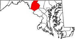
Sabillasville is an unincorporated community and census-designated place in Frederick County, Maryland, United States. [3] As of the 2010 census it had a population of 354. [4]

Contents

The Victor Cullen School Power House was listed on the National Register of Historic Places in 1987 and the Victor Cullen Center, Old Administration Building was listed in 1990. [5]

History

The first European settlers to arrive in the vicinity of Sabillasville were Swiss immigrants in the late-1750s. [6] Among the earliest settlers was Peter Zollinger (or Zullinger), who owned the land on which the present-day village is located. In 1813, the village was laid out by Andrew Smith and named Sabillasville in honor of Savilla Zollinger (wife of Peter). [7] In 1872, the Western Maryland Railroad reached Sabillasville on its line leading from Baltimore to Hagerstown and the surrounding area soon developed into a summer resort called Pen Mar (a portmanteau of Pennsylvania and Maryland). [8]

Geography

The town is located in the northwest corner of Frederick County at an elevation of 1,100 feet (340 m) above sea level, in the Harbaugh Valley, between South Mountain to the northwest and Wertenbaker Hill to the southeast. Route 550 passes through the town, leading northwest 2 miles (3 km) to Blue Ridge Summit, Pennsylvania, and southeast 7 miles (11 km) to Thurmont.

According to the U.S. Census Bureau, the Sabillasville CDP has an area of 1.5 square miles (3.9 km2), all land. [4]

Demographics

Historical population
CensusPop.Note
2020 470
U.S. Decennial Census [9]

Related Research Articles

<span class="mw-page-title-main">Allegany County, Maryland</span> County in Maryland, United States

Allegany County is located in the northwestern part of the U.S. state of Maryland. As of the 2020 census, the population was 68,106. Its county seat is Cumberland. The name Allegany may come from a local Lenape word, welhik hane or oolikhanna, which means 'best flowing river of the hills' or 'beautiful stream'. A number of counties and a river in the Appalachian region of the U.S. are named Allegany, Allegheny, or Alleghany. Allegany County is part of the Cumberland metropolitan area. It is a part of the Western Maryland "panhandle".

<span class="mw-page-title-main">Washington County, Maryland</span> County in Maryland, United States

Washington County is located in the western part of the U.S. state of Maryland. As of the 2020 census, the population was 154,705. It is the most populous county in the Western Maryland region and its county seat is Hagerstown.

<span class="mw-page-title-main">LaVale, Maryland</span> Census-designated place in Maryland, United States

LaVale is a census-designated place (CDP) in Allegany County, Maryland, United States. It is part of the Cumberland, MD-WV Metropolitan Statistical Area. The population was 4,201 as of the 2020 census.

<span class="mw-page-title-main">Barnesville, Maryland</span> Town in Maryland, United States

Barnesville is a town in Montgomery County, Maryland, United States. It was incorporated in 1888. The population was 144 at the 2020 census.

<span class="mw-page-title-main">Darnestown, Maryland</span> Census-designated place in the United States

Darnestown is a United States census-designated place (CDP) and an unincorporated area in Montgomery County, Maryland. The CDP is 17.70 square miles (45.8 km2) with the Potomac River as its southern border and the Muddy Branch as much of its eastern border. Seneca Creek borders portions of its north and west sides. The Travilah, North Potomac, and Germantown census-designated places are adjacent to it, as is the city of Gaithersburg. Land area for the CDP is 16.39 square miles (42.4 km2). As of the 2020 census, the Darnestown CDP had a population of 6,723, while the village of Darnestown is considerably smaller in size and population. Downtown Washington, D.C. is about 22 miles (35 km) to the southeast.

<span class="mw-page-title-main">North Bethesda, Maryland</span> Census-designated place in Maryland, United States

North Bethesda is an unincorporated, census-designated place (CDP) in Montgomery County, Maryland, United States, located just north-west of the U.S. capital of Washington, D.C. It had a population of 50,094 as of the 2020 census. Among its neighborhoods, the centrally-located, urbanizing district of White Flint is the commercial and residential hub of North Bethesda. The Pike & Rose development and the Pike District is an initiative of Montgomery County to brand and market this region as "North Bethesda's Urban Core". The WMATA North Bethesda metro station and Grosvenor-Strathmore metro station serve the region.

<span class="mw-page-title-main">North Potomac, Maryland</span> Census-designated place named North Potomac in Maryland, United States

North Potomac is a census-designated place and unincorporated area in Montgomery County, Maryland, United States. It is located less than 5 miles (8.0 km) north of the Potomac River, and is about 20 miles (32 km) from Washington, D.C. It has a population of 23,790 as of 2020.

<span class="mw-page-title-main">Rohrersville, Maryland</span> CDP in Maryland, United States

Rohrersville is a census-designated place (CDP) in Washington County, Maryland, United States. The population was 175 at the 2010 census.

<span class="mw-page-title-main">Point of Rocks, Maryland</span> Census-designated place in Maryland, United States

Point of Rocks is an unincorporated community and census-designated place (CDP) in Frederick County, Maryland. As of the 2010 census, it had a population of 1,466.

<span class="mw-page-title-main">Western Maryland</span> Region in Maryland, US

Western Maryland, also known as the Maryland panhandle, is the portion of the U.S. state of Maryland that typically consists of Washington, Allegany, and Garrett counties. The region is bounded by Preston County, West Virginia, to the west, the Mason–Dixon line (Pennsylvania) to the north, and the Potomac River and West Virginia to the south. At one point, at the town of Hancock, the northern and southern boundaries are separated by just 1.8 miles, the narrowest stretch in the state.

<span class="mw-page-title-main">Buckeystown, Maryland</span> Census-designated place in Maryland, United States

Buckeystown is an unincorporated community and census-designated place (CDP) in Frederick County, Maryland, United States. As of the 2010 census the population was 1,019. Buckeystown Historic District and Buckingham House and Industrial School Complex were listed on the National Register of Historic Places in 1982. Carrollton Manor was listed in 1997. Former Congressman Roscoe Bartlett lives on a farm in the town.

<span class="mw-page-title-main">Mount Pleasant (Union Bridge, Maryland)</span> Historic house in Maryland, United States

Mt. Pleasant, also known as the Clemson Family Farm, is a historic home located at Union Bridge, Carroll County, Maryland, United States. It is a five-bay by two-bay, 2+12-story brick structure with a gable roof and built about 1815. Also on the property is a brick wash house, a hewn mortised-and-tenoned-and-pegged timber-braced frame wagon shed flanked by corn cribs, and various other sheds and outbuildings. It was the home farm of the Farquhar family, prominent Quakers of Scotch-Irish descent who were primarily responsible for the establishment of the Pipe Creek Settlement.

<span class="mw-page-title-main">Libertytown, Maryland</span> Census-designated place in Maryland, United States

Libertytown is an unincorporated community and census-designated place (CDP) in Frederick County, in the U.S. state of Maryland. As of the 2010 census it had a population of 950. The Abraham Jones House was listed on the National Register of Historic Places in 1973.

<span class="mw-page-title-main">Seneca, Maryland</span> Unincorporated community in Maryland, United States

Seneca is an unincorporated community in Montgomery County, Maryland, United States. It is located near the intersection of River Road and Seneca Creek, not far from the Chesapeake and Ohio Canal and Potomac River. Its history goes back before the American Revolutionary War and it thrived when the canal was operating—having several warehouses, mills, a store, a hotel, and a school. Fighting occurred in the area on more than one occasion during the American Civil War. The community declined as the C&O Canal declined.

Danville is an unincorporated community and census-designated place (CDP) in Allegany County, Maryland, United States. As of the 2010 census it had a population of 271.

Dawson is an unincorporated community and census-designated place (CDP) in Allegany County, Maryland, United States. As of the 2010 census it had a population of 103.

Detmold is an unincorporated community and census-designated place (CDP) in Allegany County, Maryland, United States. As of the 2010 census it had a population of 71.

<span class="mw-page-title-main">Maryland Route 550</span> State highway in Maryland, United States

Maryland Route 550 is a state highway in the U.S. state of Maryland. The state highway runs 24.43 miles (39.32 km) from MD 26 in Libertytown north to Pen Mar Road in Fort Ritchie. MD 550 runs southeast–northwest across central Frederick County, connecting Fort Ritchie in the northeastern corner of Washington County and Libertytown with the towns of Thurmont and Woodsboro and the smaller communities of Creagerstown and Sabillasville. South of the highway's junction with U.S. Route 15 in Thurmont, the state highway passes through the wide valley of the Monocacy River; to the north, the highway passes along the northern edge of Catoctin Mountain and crests South Mountain near Blue Ridge Summit, Pennsylvania.

Gilmore is an unincorporated community and census-designated place (CDP) in Allegany County, Maryland, United States. As of the 2010 census it had a population of 127. It is part of the Cumberland, MD-WV Metropolitan Statistical Area.

<span class="mw-page-title-main">Darnestown Presbyterian Church</span> Historic 19th Century Presbyterian church in Darnestown, Maryland, United States

The Darnestown Presbyterian Church dates back to the 1850s, and is located in Darnestown, Maryland. It is a Presbyterian Church (USA) congregation and a member of the National Capital Presbytery. Behind the church building is a cemetery with the graves of many of the early settlers of western Montgomery County, and some of the local roads and villages are namesakes of members of those pioneering families. The first European landowner in the Darnestown area was Ninian Beall, who settled around 1749. Some Beall family members are buried in the church cemetery.

References

  1. "2020 U.S. Gazetteer Files". United States Census Bureau. Retrieved April 26, 2022.
  2. 1 2 U.S. Geological Survey Geographic Names Information System: Sabillasville, Maryland
  3. "Geographic Names Information System". Sabillasville (Populated Place). U.S. Geological Survey. January 29, 2009.
  4. 1 2 "Geographic Identifiers: 2010 Census Summary File 1 (G001), Sabillasville CDP, Maryland". American FactFinder. U.S. Census Bureau. Archived from the original on February 13, 2020. Retrieved June 2, 2016.
  5. "National Register Information System". National Register of Historic Places . National Park Service. April 15, 2008.
  6. Scharf, J. Thomas (1882). History of Western Maryland: Being a history of Frederick, Montgomery, Allegany, and Garrett Counties from the earliest period to the present day. Philadelphia: L.H. Everts. p. 612.
  7. Scharf, J. Thomas (1882). History of Western Maryland: Being a history of Frederick, Montgomery, Allegany, and Garrett Counties from the earliest period to the present day. Philadelphia: L.H. Everts. p. 614.
  8. "A Short History of Harbaugh Valley". Emmitsburg Area Historical Society.
  9. "Census of Population and Housing". Census.gov. Retrieved June 4, 2016.