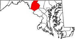
New Market West, Maryland

Last updated

New Market West, Maryland
USA Maryland location map.svg
Red pog.svg
New Market
West
Location in Maryland
Usa edcp location map.svg
Red pog.svg
New Market
West
New Market
West (the United States)
Coordinates: 39°23′13″N77°16′52″W / 39.38694°N 77.28111°W / 39.38694; -77.28111
Country Flag of the United States.svg  United States of America
State Flag of Maryland.svg  Maryland
County Flag of Frederick County, Maryland.svg Frederick
Elevation
160 m (520 ft)
Time zone UTC-5 (Eastern (EST))
  Summer (DST) UTC-4 (EDT)
Area code(s) 301 and 240
GNIS feature ID1712160 [1]

New Market West is a suburban housing community in Frederick County, in the U.S. state of Maryland. The community is located in the foothills of the Blue Ridge Mountains and is adjacent to the town of New Market. [2]

Contents

Geography

New Market West is in east-central Frederick County bordered to the south, east, and north by the town of New Market and to the west by the Linganore census-designated place. Two streams, Cherry Run and Walnut Run, run through the community. [3] [4] The primary access to the community is via Royal Oak Drive from MD 144.

Education

The community's residents feed into three schools in the Frederick County Public School system: New Market Elementary School, New Market Middle School, and Linganore High School. [5]

Climate

New Market West is located in the north eastern humid subtropical climate zone (Köppen Cfa), with hot, humid summers and moderately cold winters. [6] The community of New Market West is located in the Piedmont of the Appalachian Mountains. [7]

Climate data for New Market West, Maryland
MonthJanFebMarAprMayJunJulAugSepOctNovDecYear
Average high °F (°C)42.1
(5.6)
46.5
(8.1)
55.7
(13.2)
67.7
(19.8)
76.6
(24.8)
85.0
(29.4)
88.9
(31.6)
86.6
(30.3)
79.9
(26.6)
68.2
(20.1)
56.5
(13.6)
45.1
(7.3)
66.6
(19.2)
Average low °F (°C)25.8
(−3.4)
28.2
(−2.1)
34.5
(1.4)
44.7
(7.1)
54.0
(12.2)
63.1
(17.3)
67.9
(19.9)
66.3
(19.1)
58.9
(14.9)
47.3
(8.5)
35.8
(2.1)
30.1
(−1.1)
46.4
(8.0)
Average precipitation inches (mm)2.79
(71)
2.71
(69)
3.64
(92)
3.54
(90)
4.12
(105)
4.23
(107)
3.09
(78)
3.60
(91)
3.93
(100)
2.87
(73)
3.15
(80)
3.41
(87)
41.08
(1,043)
Average snowfall inches (cm)7.2
(18)
4.8
(12)
2.5
(6.4)
0
(0)
0
(0)
0
(0)
0
(0)
0
(0)
0
(0)
0
(0)
0.3
(0.76)
1.7
(4.3)
16.5
(42)
Source: NOAA [8]

Related Research Articles

<span class="mw-page-title-main">Clarksville, Maryland</span> Unincorporated community in Maryland

Clarksville is an unincorporated community in Howard County, Maryland; the second highest-earning county in the United States according to the U.S. Census Bureau. The community is named for William Clark, a farmer who owned much of the land on which the community now lies and served as a postal stop that opened on the 4th of July 1851.

Linganore is a census-designated place (CDP) in Frederick County, in the U.S. state of Maryland. It consists of the area around Lake Linganore, a residential community governed by a homeowners association, located east of the city of Frederick. As of the 2020 census the CDP had a population of 12,351. Prior to 2010, the area was part of the Linganore-Bartonsville CDP. The mailing address for the area is Lake Linganore, with a ZIP code of 21774.

<span class="mw-page-title-main">Mathias, West Virginia</span> Unincorporated community in West Virginia, United States

Mathias is an unincorporated community along the Lost River in Hardy County in the U.S. state of West Virginia. Mathias lies off West Virginia Route 259. Before the consolidated school of East Hardy High School at Baker, Mathias had its own educational facility, Mathias School, which served grades kindergarten through twelfth.

<span class="mw-page-title-main">Uneeda, West Virginia</span> Unincorporated community in West Virginia, United States

Uneeda is an unincorporated community on the Pond Fork River in Boone County in the U.S. state of West Virginia. The town lies along West Virginia Route 85.

Colfax is a small unincorporated community located in Guilford County, North Carolina, United States. It is located in the western part of the county. The population in 2010 was 4,136.

Branchland is an unincorporated community in western Lincoln County, West Virginia, United States. It lies along West Virginia Route 10, southwest of the town of Hamlin, the county seat of Lincoln County. Its elevation is 597 feet (182 m). It has a post office with the ZIP code 25506. Raccoon Creek Road is one of the more popular ways of transportation through the area. Branchland Post Office serves addresses within Sheridan Magisterial District of Lincoln County as well as addresses in southern Cabell County and eastern Wayne County, West Virginia.

Creston is an unincorporated community in southeastern Wirt County, West Virginia, United States. It lies at the confluence of the Little Kanawha River and the West Fork Little Kanawha River on West Virginia Route 5, southeast of the town of Elizabeth, the county seat of Wirt County. Its elevation is 653 feet (199 m). Creston had a post office, which closed on June 25, 2011. The community was named for a drainage divide near the town site.

Belva is an unincorporated community and census-designated place in west Nicholas County and north Fayette County, West Virginia, United States; while the CDP only includes the Nicholas County portion, the Fayette County portion is considered part of the community. The town is situated at the bottomland surrounding the convergence of Bells Creek with Twentymile Creek and, subsequently, Twenty Mile Creek with the Gauley River. Belva is also the location of the convergence of two state highways: West Virginia Route 16 and West Virginia Route 39.

Neola is an unincorporated community in northeastern Greenbrier County, West Virginia, United States. It lies along West Virginia Route 92 north of the city of White Sulphur Springs. Its elevation is 2,037 feet (621 m).

Rock View is an unincorporated community in Wyoming County, West Virginia, United States.

<span class="mw-page-title-main">Fischer, Texas</span> United States historic place

Fischer is an unincorporated community in Comal County, Texas, United States. The population was 688 at the 2010 census. The community is a part of the Texas-German Belt which runs from Schulenburg in the east, and west through the Hill Country to Fredericksburg. Most residents of Fischer have German-Texan ancestry, and the name Fischer is named after Otto and Hermann Fischer, German immigrants.

Lorentz is an unincorporated community in Upshur County, West Virginia, United States. Lorentz is located on U.S. routes 33 and 119, 4 miles (6.4 km) west-northwest of Buckhannon. Lorentz has a post office with ZIP code 26229.

Hico is a census-designated place (CDP) in Fayette County, West Virginia, United States. Hico is located at the junction of U.S. routes 19 and 60, 7 miles (11 km) northeast of Fayetteville. Hico has a post office with ZIP code 25854. As of the 2010 census, its population was 272.

Borderland is an unincorporated community in Mingo County, West Virginia, United States. Borderland is located along the Tug Fork and U.S. Routes 52 and 119, 3 miles (4.8 km) northwest of Williamson. Borderland had a post office, which opened on March 6, 1905, and closed on June 20, 2009.

<span class="mw-page-title-main">Crabapple, Texas</span> Unincorporated community in Texas, United States

Crabapple, Texas is an unincorporated farming and ranching community 10.5 miles (16.9 km) north of Fredericksburg in Gillespie County, Texas located on Crabapple Creek, about halfway between Fredericksburg and Enchanted Rock State Park at an elevation of 1,775 feet. The school was designated a Recorded Texas Historic Landmark number 10022 in 1994. The school was added to the National Register of Historic Places in Texas on May 6, 2005, NRHP Reference #:05000390.

Lytton Springs is an unincorporated community in northeastern Caldwell County, Texas, United States. According to the Handbook of Texas, the community had a population of 500 in 2000. It is located within the Greater Austin metropolitan area.

Procious is an unincorporated community in Clay County, West Virginia, United States. Procious is located on the Elk River and West Virginia Route 4, 7 miles (11 km) west-northwest of Clay. Procious has a post office with ZIP code 25164.

Elk Run Junction is an unincorporated community in Boone County, West Virginia, United States.

Alpena is an unincorporated community in Randolph County, West Virginia, United States.

Keene is a home rule-class city located in Jessamine County, Kentucky, in the United States. It is home to the Keene Springs Hotel. The U.S. Census Bureau does not record Keene as a city and does not publish a population figure for the community.

References

  1. U.S. Geological Survey Geographic Names Information System: New Market West
  2. "New Market West - About Us". New Market West. New Market West. Retrieved August 12, 2017.
  3. "U.S. Geological Survey Geographic Names Information System: Walnut Run". Geographic Name Information System. Retrieved August 12, 2017.
  4. "U.S. Geological Survey Geographic Names Information System: Cherry Run". Geographic Name Information System. Retrieved August 12, 2017.
  5. "Frederick County Public School (Maryland) Attendance Maps". FCPS Attendance Areas. Retrieved August 13, 2017.
  6. "Köppen climate types of the United States" . Retrieved October 26, 2017.
  7. "Topography of the Appalachian/Piedmont" . Retrieved October 26, 2017.
  8. "NCDC: U.S. Climate Normals". National Oceanic and Atmospheric Administration. October 2017. Retrieved October 25, 2017.