
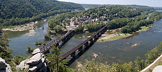
Harpers Ferry is a historic town in Jefferson County, West Virginia, United States, in the lower Shenandoah Valley. The population was 285 at the 2020 census. Situated at the confluence of the Potomac and Shenandoah rivers, where the U.S. states of Maryland, Virginia, and West Virginia meet, it is the easternmost town in West Virginia.

Paw Paw is a town in Morgan County, West Virginia, United States. The population was 410 at the 2020 census. The town is known for the nearby Paw Paw Tunnel. Paw Paw was incorporated by the Circuit Court of Morgan County on April 8, 1891, and named after pawpaw, a wild fruit that grows in abundance throughout this region. Paw Paw is the westernmost incorporated community in Morgan County, and the Hagerstown-Martinsburg, MD-WV Metropolitan Statistical Area.

The Baltimore and Ohio Railroad was the first common carrier railroad and the oldest railroad in the United States. It operated as B&O from 1830 until 1987, when it was merged into the Chessie System; its lines are today controlled by CSX Transportation.
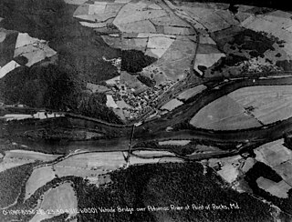
Point of Rocks is an unincorporated community and census-designated place (CDP) in Frederick County, Maryland. As of the 2010 census, it had a population of 1,466.

U.S. Route 340 is a spur route of US 40, and runs from Greenville, Virginia, to Frederick, Maryland. In Virginia, it runs north–south, parallel and east of US 11, from US 11 north of Greenville via Waynesboro, Grottoes, Elkton, Luray, Front Royal, and Berryville to the West Virginia state line. A short separate piece crosses northern Loudoun County on its way from West Virginia to Maryland.

The Chesapeake and Ohio Canal National Historical Park is located in the District of Columbia and the state of Maryland. The park was established in 1961 as a National Monument by President Dwight D. Eisenhower to preserve the neglected remains of the Chesapeake and Ohio Canal and many of its original structures.

The Western Maryland Railway was an American Class I railroad (1852–1983) that operated in Maryland, West Virginia, and Pennsylvania. It was primarily a coal hauling and freight railroad, with a small passenger train operation.
Harpers Ferry National Historical Park, originally Harpers Ferry National Monument, is located at the confluence of the Potomac and Shenandoah rivers in and around Harpers Ferry, West Virginia. The park includes the historic center of Harpers Ferry, notable as a key 19th-century industrial area and as the scene of John Brown's failed abolitionist uprising. It contains the most visited historic site in the state of West Virginia, John Brown's Fort.

Virginius Island is a formerly inhabited island of some 12 acres (4.9 ha), on the Shenandoah River in Harpers Ferry, West Virginia. The island was created by the Shenandoah Canal, constructed by the Patowmack Company between 1806 and 1807, which separates it from the town of Harpers Ferry. The canal was constructed to enable boats to bypass rapids on the river, and also channel water to drive machinery. In the nineteenth century Virginius Island contained Harpers Ferry's industry and working-class housing: a boarding house and row houses. Virginius Island is part of the Harpers Ferry National Historical Park.

The Metropolitan Subdivision is a railroad line owned and operated by CSX Transportation in the District of Columbia and the U.S. state of Maryland. The 53-mile line runs from Washington, D.C., northwest to Weverton, Maryland, along the former Metropolitan Branch of the Baltimore and Ohio Railroad.
Weverton is an unincorporated community hamlet located in the southern tip of Washington County, Maryland, United States, near the north shore of the Potomac River. Its population is about 500. Weverton is located at the intersection of MD Route 67 and U.S. Route 340. The nearest incorporated communities are Harpers Ferry, West Virginia and Brunswick. Weverton's approximate elevation is 475 feet (145 m) above sea level.

Maryland Route 180 is a state highway in the U.S. state of Maryland. Known for most of its length as Jefferson Pike, the state highway runs 14.95 miles (24.06 km) from U.S. Route 340 in Knoxville east to Ballenger Creek Pike and Interstate 70 (I-70) in Frederick. MD 180 is the old alignment of US 340 through Knoxville, Petersville, and Jefferson in the Middletown Valley of western Frederick County. The state highway was originally constructed in the early 1910s and designated US 340 in 1927. MD 180 was assigned to the highway bypassed by the US 340 freeway between Sandy Hook in far southern Washington County and Jefferson in the mid-1960s. The state highway was extended east to Frederick and south along Ballenger Creek Pike after the US 340 freeway was completed in the late 1960s. MD 180 was rolled back to Frederick and removed from Washington County in 1989.

Harpers Ferry station is a historic railway station in Harpers Ferry, West Virginia. It is currently served by Amtrak's Capitol Limited as well as MARC commuter service. Built by the Baltimore and Ohio Railroad, the station is part of the Harpers Ferry Historic District.

St. Peter's Roman Catholic Church in Harpers Ferry, West Virginia occupies a prominent location on the heights above Harpers Ferry. The original church was built in 1833 in a pseudo-Gothic style which it kept through the Civil War, being the only church in Harpers Ferry to escape destruction during the war. The church was extensively altered in 1896 in the then-popular Neo-Gothic style to produce the church seen today. The church commands a sweeping vista across the gorge of the Shenandoah River above its confluence with the Potomac River. The street along the side of the church building is part of the Appalachian Trail. A short trail leads from the church to Jefferson Rock. St. Peter's Church is a mission church of St. James in Charles Town. Mass is offered at the historic church every Sunday at 9:30 a.m.

The B & O Railroad Potomac River Crossing is a 15-acre (6.1 ha) historic site where a set of railroad bridges, originally built by the Baltimore and Ohio Railroad, span the Potomac River between Sandy Hook, Maryland and Harpers Ferry, West Virginia. The site was added to the National Register of Historic Places on February 14, 1978, for its significance in commerce, engineering, industry, invention, and transportation.

Maryland Route 478 is a state highway in the U.S. state of Maryland. Known as Knoxville Road, the state highway runs 1.88 miles (3.03 km) from MD 180 in Knoxville east to Florida Avenue in Brunswick. MD 478 was constructed as MD 70 in the late 1920s. In 1950, MD 70 was replaced with an extended MD 464. MD 478 was assigned to Knoxville Road after MD 464 was rerouted to its present terminus in 1968.

A series of projects in the 18th and 19th centuries attempted to make the Potomac River navigable and connect the Ohio River valley and the East Coast. The first project was started by the Potomac Company, but it was the Chesapeake and Ohio Canal Company (C&O) that finished the project in the 1830s and 1840s.

The Pennyfield Lock and lockhouse are part of the 184.5-mile (296.9 km) Chesapeake and Ohio Canal that operated in the United States along the Potomac River from the 1830s through 1923. The lock, located at towpath mile-marker 19.7, is near River Road in Montgomery County, Maryland. The original lock house was built in 1830, and its lock was completed in 1831.


