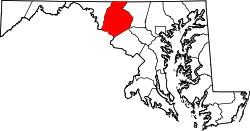
Spoolsville is an unincorporated community in Frederick County, Maryland, United States. [1] Bowlus Mill House was listed on the National Register of Historic Places in 1996. [2]
In law, an unincorporated area is a region of land that is not governed by a local municipal corporation; similarly an unincorporated community is a settlement that is not governed by its own local municipal corporation, but rather is administered as part of larger administrative divisions, such as a township, parish, borough, county, city, canton, state, province or country. Occasionally, municipalities dissolve or disincorporate, which may happen if they become fiscally insolvent, and services become the responsibility of a higher administration. Widespread unincorporated communities and areas are a distinguishing feature of the United States and Canada. In most other countries of the world, there are either no unincorporated areas at all, or these are very rare; typically remote, outlying, sparsely populated or uninhabited areas.
Frederick County is located in the northern part of the U.S. state of Maryland. As of the 2010 U.S. Census, the population was 240,336. The county seat is Frederick.
Maryland is a state in the Mid-Atlantic region of the United States, bordering Virginia, West Virginia, and the District of Columbia to its south and west; Pennsylvania to its north; and Delaware to its east. The state's largest city is Baltimore, and its capital is Annapolis. Among its occasional nicknames are Old Line State, the Free State, and the Chesapeake Bay State. It is named after the English queen Henrietta Maria, known in England as Queen Mary, who was the wife of King Charles I.
Wayne Township is a township in Dauphin County, Pennsylvania, United States. The population was 1,341 at the 2010 census.
West Wheatfield Township is a township in Indiana County, Pennsylvania, United States. The population was 2,314 at the 2010 census. The township includes the communities of Centerville, Climax, Clyde, Conpitt Junction, Germany, Heshbon, India, and Robinson.
Spruce Hill Township is a township in Juniata County, Pennsylvania, United States. The population was 834 at the 2010 census, up from 724 at the 2000 census.
Clay Township is one of fourteen townships in Morgan County, Indiana, United States. As of the 2010 census, its population was 4,292 and it contained 1,707 housing units.
Biggs Ford Site is an archaeological site near Frederick in Frederick County, Maryland. It is one of the few known, large late prehistoric Native American village sites near the Monocacy River. The site dates from the Middle to Late Woodland period.
Nolands Ferry I Archeological Site is an archaeological site near Tuscarora. It is a prehistoric occupation site located in the Monocacy region of southern Frederick County, Maryland. Diagnostic artifacts at the site indicate that the site was almost continuously inhabited from the Paleo-Indian period to the early 19th century, with the most substantial inhabitation occurring during the Late Woodland period.
New London is an unincorporated community in Frederick County, Maryland, United States. Thomas Maynard House was listed on the National Register of Historic Places in 1979.
Cooksville is an unincorporated community in Howard County, Maryland, United States. In 2016, the population was 631. The town was founded by Thomas Cook in 1802. The crossroads town was anchored by the Joshua Roberts Tavern, where General Lafayette visited in 1824. The inn was destroyed by fire, rebuilt, and demolished a second time. Thomas Cook exchanged his stake in Cooksville with Thomas Beale Dorsey for the 231 acre Round About Hills slave plantation. A Post Office opened on the 4th of July 1851, the same year Howard County was formed from Anne Arundel County. Roberts Inn was listed on the National Register of Historic Places in 1973.
Glenwood is an unincorporated community in Howard County, Maryland, United States. It is located between Baltimore and Washington, D.C., therefore attracting commuters to those employment centers. The community features acres of open space and is districted to Bushy Park Elementary, Glenwood and Folly Quarter Middle, and Glenelg High schools. Union Chapel was listed on the National Register of Historic Places in 1975 and Round About Hills was added in 2008.
Burtner is an unincorporated community in Washington County, Maryland, United States. Search Well was listed on the National Register of Historic Places in 1983.
Spielman is an unincorporated community in Washington County, Maryland, United States. The Hogmire-Berryman Farm was listed on the National Register of Historic Places in 1980.
Union Mills is an unincorporated community in Carroll County, Maryland, United States. The community is home to the Union Mills Homestead Historic District, added to the National Register of Historic Places in 1971. The Solomon Arter House was listed in 1987 and the Philip and Uriah Arter Farm in 2006.
Uniontown is an unincorporated community in Carroll County, Maryland, United States. The community is home to the Uniontown Historic District, added to the National Register of Historic Places in 1986.
Linwood is an unincorporated community in Carroll County, Maryland, United States. The community is home to the Linwood Historic District, added to the National Register of Historic Places in 1980.
Keysville is an unincorporated community in Carroll County, Maryland, United States. Terra Rubra was listed on the National Register of Historic Places in 1978.
Silver Run is an unincorporated community in Carroll County, Maryland, United States.Christopher Erb House was listed on the National Register of Historic Places in 1985.
Nelson Bar is a former settlement in Butte County, California. It was located 5.25 miles (8.45 km) southeast of Paradise on the West Branch of the Feather River, at an elevation of 974 feet. It is now under Lake Oroville.
Woolsey Flat is a former settlement in Nevada County, California. Woolsey Flat is located 4 miles (6.4 km) north-northeast of North Bloomfield. It is situated at an elevation of 4,199 ft (1,280 m) above sea level.
Oak Corner is an unincorporated community in Caroline County, in the U.S. state of Virginia.
Valentines is an unincorporated community located in Brunswick County, in the U.S. state of Virginia.
Coordinates: 39°27′00″N77°33′41″W / 39.45000°N 77.56139°W
A geographic coordinate system is a coordinate system that enables every location on Earth to be specified by a set of numbers, letters or symbols. The coordinates are often chosen such that one of the numbers represents a vertical position and two or three of the numbers represent a horizontal position; alternatively, a geographic position may be expressed in a combined three-dimensional Cartesian vector. A common choice of coordinates is latitude, longitude and elevation. To specify a location on a plane requires a map projection.
This article about a location in Frederick County Maryland is a stub. You can help Wikipedia by expanding it. |