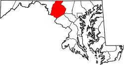
Monrovia, Maryland

Last updated

Monrovia, Maryland
USA Maryland location map.svg
Red pog.svg
Monrovia
Location in Maryland
Usa edcp location map.svg
Red pog.svg
Monrovia
Monrovia (the United States)
Coordinates: 39°21′25″N77°16′29″W / 39.35694°N 77.27472°W / 39.35694; -77.27472
CountryFlag of the United States.svg  United States
State Flag of Maryland.svg  Maryland
County 2023 flag of Frederick County, Maryland.svg Frederick
Area
[1]
  Total2.25 sq mi (5.82 km2)
  Land2.25 sq mi (5.82 km2)
  Water0.00 sq mi (0.00 km2)
Elevation
[2]
535 ft (163 m)
Population
 (2020)
  Total2,702
  Density1,203.56/sq mi (464.64/km2)
Time zone UTC−5 (Eastern (EST))
  Summer (DST) UTC−4 (EDT)
ZIP code
21770
Area code(s) 301 and 240
FIPS code 24-53100
GNIS feature ID2583659 [2]

Monrovia is an unincorporated community and census-designated place (CDP) in Frederick County, in the U.S. state of Maryland. As of the 2020 census it had a population of 2,702. [3]

Contents

Etymology

Though a post office was established in Monrovia on January 15, 1833, it is not known that the town was named Monrovia in the 1830s. In the 1820s, the town was known as "Hall Towne," likely after Nicholas Hall, a founder of New Market. When the name Monrovia was applied to the town is unknown, however why it was named such was either after the U.S. President James Monroe, [4] or perhaps for an event described by Reverend Herbert Austin Cooper in 1997: [5]

The California Gold Rush of 1848 played a part in that. Two men from this area went to California in search of gold. Unsuccessful there, they then heard of new gold discoveries in Monrovia, Liberia (West Africa). So they went there and worked in the Monrovia mines. In Liberia, one of the two men died. After the man died, they put his body in a fish barrel, used to preserve salt-water fish, and filled the barrel with alcohol to preserve the body. The barrel was then shipped all the way around Cape Horn and, ultimately, to the Port of Baltimore. From there, the body in a barrel went by rail to what is now Monrovia, Maryland. It was received at the general store there, and the alcohol was dumped into Bush Creek, after which they had a funeral service with Elder Walker presiding. [6]

It was suggested by Reverend Cooper that this shipment from Monrovia, Liberia, resulted in the town along Bush Creek being named "Monrovia."

Geography

The original unincorporated community of Monrovia is located along Maryland Route 75 (Green Valley Road) in southeastern Frederick County, 1 mile (1.6 km) south of New Market, Maryland. The Monrovia CDP extends south of the original Monrovia as far as Maryland Route 80 (Fingerboard Road) and west to include nearly all of Ed McClain Road. According to the U.S. Census Bureau, the Monrovia CDP has a total area of 2.2 square miles (5.8 km2), all land.

Education

Monrovia is part of the Frederick County public school system. Children from the area attend Green Valley or Kemptown Elementary School, Windsor Knolls Middle School, and Urbana High School or Linganore High School, due to redistricting in the fall of 2010.

Transport

The two major roads in the area are Maryland Route 75 and Maryland Route 80. MD 80 leads west 4.5 miles (7.2 km) to Urbana and southeast 7 miles (11 km) to Damascus (via MD 27), while MD 75 leads north to New Market and I-70/US-40, and also south 5 miles (8 km) to Hyattstown and MD 355.

History

In 1831, Monrovia became a station on the Baltimore and Ohio Railroad and provided service to the mills and access for travelers to New Market, MD. [7] A watering station for the trains was built later in 1840. [8] Monrovia was impacted by the Civil War with the Monrovia General Store, used as a dry goods store from the mid-nineteenth century until the early twentieth century, being sacked by Confederate troops after the Battle of Monocacy. [9] During the Civil War, Monrovia also made the front page of the September 16, 1862 issue of The New York Herald:

"We pushed on to Monrovia Station, on the line of the Baltimore and Ohio Railroad, on the way to New Market, and while passing through an incident occurred well worth relating. I was riding in the rear when I was attracted by the most deafening shouts some distance ahead. I instantly went forward, and saw something that made me feel like shouting too. On a slight eminence on the side of the road stood two ladies and a little girl. In the child's hand was a small but very pretty American flag, which she was waving with all the ardor and enthusiasm of a youthful patriot. The men cheered until they were husky, and most of the officers, as they passed, took off their caps and saluted the national emblem. Upon conversing with the ladies I was informed that this was the only American flag that the rebels had left, and the reason for that was they could not find it. All the rest had been destroyed or carried away as trophies. The rebel cavalry destroyed here the post office and other government property. They left the place on Thursday afternoon, and fell back to New Market." [10]

Monrovia was the largest community in the New Market election district in 1880. [11] The Monrovia Central Trust Bank closed in 1929. [11] Monrovia's largest employer, a cannery, closed in the 1930s. [11] Another large employer, the Nicodemus Mill, also closed in the 1930s. [11]

The 75-80 dragway opened in 1960. [12] [13] The track closed on October 30, 2005, with no plans to resume races. [14] The closing prompted a significant public response, and renovations to the dragway began in 2007. The track reopened on April 3, 2009. The track closed for the final time on September 28, 2013, and was planned to be replaced by a housing development. [15] However, the TV show MotorWeek , which had been using the Dragway for its car tests since 1982, continued to use the remnants of the drag strip until partway through its 40th season in 2021, and even still credited the Dragway in its end credits. The show has since moved to the Mason-Dixon Dragway in Boonsboro.

A developer owns land in Monrovia and had proposed building Monrovia Town Center, which was planned to consist of 930 single-family homes, 580 townhomes, and retail. [16] [17] The developer later revised the plan, reserving half of the homes for residents who are at least 55 years old, reducing the number of homes from 1,510 to 1,250, and reducing the size of the development from 457 to 392 acres (1.8 to 1.6 km2). [18] [19] Residents have testified at meetings of the Frederick County Planning Commission to voice their disagreement with the proposed development, saying that the development would overburden the area's roads and schools and change the rural character of the area. [17] [20] In 2014, Frederick County's Board of County Commissioners voted to change the area's zoning. [21] After a lawsuit against the Monrovia Town Center by Residents Against Landsdale Expansion (RALE) was won in 2017 in Frederick County Circuit Court, the Maryland Court of Special Appeals upheld the lower court decision in 2019, and later Maryland's Court of Appeals upheld the ruling in 2020. [22]

Notes

  1. "2020 U.S. Gazetteer Files". United States Census Bureau. Retrieved April 26, 2022.
  2. 1 2 U.S. Geological Survey Geographic Names Information System: Monrovia, Maryland
  3. Geographic Identifiers: 2020: DEC Redistricting Data (PL 94-171), Monrovia CDP, Maryland
  4. The Place Names of Maryland, Their Origin and Meaning. Hamill Kenny, 1989.
  5. Brethren Historical Library and Archives
  6. Land of Promise, A Brief History of Monrovia, Maryland, And Some Local Legends. Joseph Seng, 2002
  7. Maryland Inventory of Historic Properties, Monrovia Survey District, F-5-14.
  8. Back When, the Story of Historic New Market Maryland. Joseph Seng, 2007
  9. Maryland Inventory of Historic Properties, Monrovia General Store, F-5-53.
  10. September 16, 1862 "Our Frederick Correspondence". The New York Herald.
  11. 1 2 3 4 Garnder, Karen (August 12, 2002). "Monrovia was once a thriving village". The Frederick News-Post.
  12. Fortney, Sarah (June 25, 2007). "Street rod driver never stops enjoying the ride". The Frederick News-Post.
  13. Dillon, Stanley C. (September 19, 1990). "Dragway Will Celebrate 30th Year on Saturday". The Baltimore Sun. p. 22.
  14. Tucker, Abigail (October 30, 2005). "A 45-year tradition nears the finish line: 75-80 Dragway in Monrovia has been Bill Wilcom's life but tonight will mark the final roar of the engines". The Baltimore Sun. p. 1A.
  15. Brown, Christian (April 9, 2009). "75-80 Dragway reopens". The Gazette. Retrieved May 18, 2013.
  16. Rigaux, Pamela (October 8, 2005). "Monrovia may get 1,600 new homes". The Frederick News-Post.
  17. 1 2 Rodgers, Bethany (October 24, 2013). "Proposed Monrovia Town Center draws crowds to county hearing". The Frederick News-Post.
  18. Rodgers, Bethany (February 21, 2014). "Mapping the future of Monrovia". The Frederick News-Post.
  19. Karas, Rachel S. (April 9, 2014). "Traffic concerns raised at Monrovia Town Center hearing". The Frederick News-Post.
  20. Rodgers, Bethany (October 15, 2013). "Young describes closed-session votes on Monrovia Town Center". The Frederick News-Post.
  21. Mullins, Patti Borda (April 18, 2016). "Monrovia Town Center hearing postponed: Settlement eyed". The Frederick News-Post.
  22. 75-80 Properties, L.L.C., et al. v. RALE, Inc., et al. August 24, 2020.

Related Research Articles

<span class="mw-page-title-main">Frederick County, Maryland</span> County in Maryland, United States

Frederick County is a county located in Maryland, United States. As of the 2020 U.S. census, the population was 271,717. The county seat is Frederick. The county is part of the Capital region of the state.

<span class="mw-page-title-main">Owings Mills, Maryland</span> Census-designated place in Maryland, United States

Owings Mills is an unincorporated community and census-designated place in Baltimore County, Maryland, United States. It is a suburb of Baltimore. Per the 2020 census, the population was 35,674. Owings Mills is home to the northern terminus of the Baltimore Metro Subway, and housed the Owings Mills Mall until its closure in 2015. It is also home to the Baltimore Ravens' headquarters facility, and the studios for Maryland Public Television. In 2008, CNNMoney.com named Owings Mills number 49 of the "100 Best Places to Live and Launch".

<span class="mw-page-title-main">Towson, Maryland</span> Census-designated place in Maryland, United States

Towson is an unincorporated community and a census-designated place in Baltimore County, Maryland, United States. The population was 59,533 in the 2020 census. It is the county seat of Baltimore County and the second-most populous unincorporated county seat in the United States.

<span class="mw-page-title-main">Eldersburg, Maryland</span> Census-designated place in Maryland, United States

Eldersburg is an unincorporated community and census-designated place (CDP) in Carroll County, Maryland, United States. The population was 30,531 at the 2010 census.

<span class="mw-page-title-main">Ellicott City, Maryland</span> Census-designated place in Maryland, United States

Ellicott City is an unincorporated community and census-designated place in, and the county seat of, Howard County, Maryland, United States. Part of the Baltimore metropolitan area, its population was 75,947 at the 2020 census, making it the most populous unincorporated county seat in the country.

<span class="mw-page-title-main">Darnestown, Maryland</span> Census-designated place in the United States

Darnestown is a United States census-designated place (CDP) and an unincorporated area in Montgomery County, Maryland. The CDP is 17.70 square miles (45.8 km2) with the Potomac River as its southern border and the Muddy Branch as much of its eastern border. Seneca Creek borders portions of its north and west sides. The Travilah, North Potomac, and Germantown census-designated places are adjacent to it, as is the city of Gaithersburg. Land area for the CDP is 16.39 square miles (42.4 km2). As of the 2020 census, the Darnestown CDP had a population of 6,723, while the village of Darnestown is considerably smaller in size and population. Downtown Washington, D.C. is about 22 miles (35 km) to the southeast.

<span class="mw-page-title-main">Travilah, Maryland</span> Census-designated place in Maryland

Travilah is a United States census-designated place and an unincorporated area in Montgomery County, Maryland. It is 17.28 square miles (44.8 km2) located along the north side of the Potomac River, and surrounded by the communities of Potomac, North Potomac, and Darnestown—all census-designated places. It had a population of 11,985 as of the 2020 census.

<span class="mw-page-title-main">Beltsville, Maryland</span> CDP in Maryland, United States

Beltsville is a census-designated place (CDP) in northern Prince George's County, Maryland, United States. The community was named for Truman Belt, a local landowner. The 2020 census counted 20,133 residents. Beltsville includes the unincorporated community of Vansville.

<span class="mw-page-title-main">Stockton, Maryland</span> CDP in Maryland, United States

Stockton is a census-designated place (CDP) in Worcester County, Maryland, United States. The population was 92 at the 2010 census. It is part of the Salisbury, Maryland-Delaware Metropolitan Statistical Area.

<span class="mw-page-title-main">Jessup, Maryland</span> Census-designated place in Maryland

Jessup is an unincorporated community and census-designated place in Howard and Anne Arundel counties, about 15 miles (24 km) southwest of Baltimore, Maryland, United States. Per the 2020 census, the population was 10,535.

<span class="mw-page-title-main">Lisbon, Maryland</span> Census-designated place in Maryland

Lisbon is a census-designated place located in western Howard County in the state of Maryland, United States, located roughly between Baltimore and Frederick and north of Washington, D.C. It is contained in an area of roughly one square mile. Lisbon is located along Interstate 70 and Maryland Route 144 and is home to the first roundabout in Maryland. It first appeared as a CDP in the 2020 Census with a population of 282.

<span class="mw-page-title-main">Urbana, Maryland</span> Census-designated place in Maryland, United States

Urbana is a suburban census-designated place located in Frederick County, Maryland, United States. It lies at the I-270/MD 80 interchange, approximately 7.5 miles (12.1 km) south-east of Frederick and about 37 miles (60 km) north-west of Washington, D.C. Urbana started to develop circa 1999 and, as of the 2010 census, had a population of 9,175. It is part of the Washington metropolitan area.

<span class="mw-page-title-main">Maryland Route 144</span> State highway in Maryland, US

Maryland Route 144 is a collection of state highways in the U.S. state of Maryland. These highways are sections of old alignment of U.S. Route 40 between Cumberland and Baltimore. Along with US 40 Scenic, US 40 Alternate, and a few sections of county-maintained highway, MD 144 is assigned to what was once the main highway between the two cities, connecting those endpoints with Hancock, Hagerstown, Frederick, New Market, Mount Airy, Ellicott City, and Catonsville. MD 144 has seven disjoint sections of mainline highway that pass through the Appalachian Mountains in Allegany and Washington counties and the rolling Piedmont of Frederick, Carroll, Howard, and Baltimore counties.

<span class="mw-page-title-main">Maryland Route 355</span> State highway in Montgomery and Frederick Counties, Maryland, United States

Maryland Route 355 (MD 355) is a 36.75-mile (59.14 km) north–south road in western central Maryland in the United States. The southern terminus of the route is in Bethesda in Montgomery County, where Wisconsin Avenue meets the county's border with Washington, D.C. The northern terminus is just north of a bridge over Interstate 70 (I-70)/U.S. Route 40 (US 40) in the city of Frederick in Frederick County, where the road continues north as Market Street through Frederick towards MD 26.

<span class="mw-page-title-main">Buckeystown, Maryland</span> Census-designated place in Maryland, United States

Buckeystown is an unincorporated community and census-designated place (CDP) in Frederick County, Maryland, United States. As of the 2010 census the population was 1,019. Buckeystown Historic District and Buckingham House and Industrial School Complex were listed on the National Register of Historic Places in 1982. Carrollton Manor was listed in 1997. Former Congressman Roscoe Bartlett lives on a farm in the town.

<span class="mw-page-title-main">Maryland Route 80</span> State highway in Maryland, US

Maryland Route 80 is a state highway in the U.S. state of Maryland. Known for most of its length as Fingerboard Road, the highway runs 14.79 miles (23.80 km) from MD 85 in Buckeystown east to MD 27 near Damascus. MD 80 connects Buckeystown and Urbana in southern Frederick County with Damascus in far northern Montgomery County. At the suburban community of Urbana, the route has junctions with Interstate 270 (I-270) and MD 355. MD 80 was constructed between MD 27 and MD 75 in the mid- to late 1920s. The highway was built from Urbana to MD 75 in the mid-1930s and from Buckeystown to Urbana in the late 1930s. MD 80 was relocated at its western end in the mid-1970s and relocated and expanded through Urbana in the 2000s.

<span class="mw-page-title-main">Maryland Route 75</span> State highway in Maryland, US

Maryland Route 75 is a state highway in the U.S. state of Maryland. Known for most of its length as Green Valley Road, the state highway runs 28.40 miles (45.71 km) from MD 355 near Hyattstown north to MD 31 in New Windsor. MD 75 serves as the main north–south highway of eastern Frederick County, where it connects Hyattstown with New Market, Libertytown, Johnsville, and the Carroll County town of Union Bridge. The first sections of MD 75 were constructed around New Windsor and between Green Valley and New London in the early 1910s. The latter highway was extended south to Green Valley in the late 1910s. In the early 1920s, MD 75 was constructed between New Windsor and Union Bridge and from Libertytown to Johnsville. The remainder of the state highway was constructed in the late 1920s and early 1930s. MD 75 was relocated between Union Bridge and New Windsor in the early 1960s, around its interchange with Interstate 70 (I-70)/U.S. Route 40 in New Market in the early 1970s, and at its northern terminus in New Windsor in 2007.

<span class="mw-page-title-main">Libertytown, Maryland</span> Census-designated place in Maryland, United States

Libertytown is an unincorporated community and census-designated place (CDP) in Frederick County, in the U.S. state of Maryland. As of the 2010 census it had a population of 950. The Abraham Jones House was listed on the National Register of Historic Places in 1973.

<span class="mw-page-title-main">Ijamsville, Maryland</span> Unincorporated community in Maryland, United States

Ijamsville is an unincorporated community located 7 miles (11 km) southeast of Frederick, in Frederick County, Maryland, United States. The town was founded by Plummer Ijams, a descendant of Welsh immigrants, from whom the town took its name. The discovery of high-quality slate in the area led to Ijamsville's brief era as a mining town, which lasted until it transitioned to agriculture in the mid-1800s. In the mid-to-late 20th century, large quantities of land in Ijamsville were purchased by developers, and the town became primarily residential as a suburb of Frederick, Baltimore, and D.C.

Harold F. "Bud" Otis is an Elder of the Seventh-day Adventist Church and an American publisher and politician.