Interstate 81 (I-81) is a north–south Interstate Highway in the eastern part of the United States. Its southern terminus is at I-40 in Dandridge, Tennessee; its northern terminus is on Wellesley Island, New York at the Canadian border, where the Thousand Islands Bridge connects it to Highway 137 and ultimately to Highway 401, the main Ontario freeway connecting Detroit via Toronto to Montreal. The major metropolitan areas along the route of I-81 include the Tri-Cities of Tennessee; Roanoke in Virginia; Hagerstown in Maryland; Harrisburg and the Wyoming Valley in Pennsylvania; and Binghamton and Syracuse in New York.

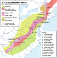
The Great Appalachian Valley, also called The Great Valley or Great Valley Region, is one of the major landform features of eastern North America. It is a gigantic trough, including a chain of valley lowlands, and the central feature of the Appalachian Mountains system. The trough stretches about 1,200 miles (1,900 km) from Quebec in the north to Alabama in the south and has been an important north–south route of travel since prehistoric times.

The Allegheny Mountain Range, informally the Alleghenies, is part of the vast Appalachian Mountain Range of the Eastern United States and Canada and posed a significant barrier to land travel in less developed eras. The Allegheny Mountains have a northeast–southwest orientation, running for about 300 miles (480 km) from north-central Pennsylvania southward, through western Maryland and eastern West Virginia.

The Ridge-and-Valley Appalachians, also called the Ridge and Valley Province or the Valley and Ridge Appalachians, are a physiographic province of the larger Appalachian Highlands division. The physiographic province is divided into three sections: the Hudson Valley, the Central, and the Tennessee.

Western Maryland, also known as the Maryland panhandle, is the portion of the U.S. state of Maryland that typically consists of Frederick, Washington, Allegany, and Garrett counties. The region is bounded by Preston County, West Virginia, to the west, the Mason–Dixon line (Pennsylvania) to the north, and the Potomac River and West Virginia to the south. At one point, at the town of Hancock, the northern and southern boundaries are separated by just 1.8 miles, the narrowest stretch in the state.
The Western Maryland Railway was an American Class I railroad (1852–1983) that operated in Maryland, West Virginia, and Pennsylvania. It was primarily a coal hauling and freight railroad, with a small passenger train operation.

Blue Mountain, Blue Mountain Ridge, or the Blue Mountains of Pennsylvania is a ridge of the Appalachian Mountains in eastern Pennsylvania. Forming the southern and eastern edge of the Ridge-and-Valley Appalachians physiographic province in Pennsylvania, Blue Mountain extends 150 miles (240 km) from the Delaware Water Gap on the New Jersey border in the east to Big Gap in Franklin County in south-central Pennsylvania at its southwestern end.
Shenandoah Valley Railroad was a line completed on June 19, 1882, extending up the Shenandoah Valley from Hagerstown, Maryland through the West Virginia panhandle into Virginia to reach Roanoke, Virginia and to connect with the Norfolk and Western Railway (N&W). The development of this railroad had considerable backing from the Pennsylvania Railroad. In September 1890 it went into bankruptcy and was reorganized as the Shenandoah Valley Railway. In December 1890, it became part of N&W. Today the tracks are a major artery of the Norfolk Southern system.
South Mountain is the northern extension of the Blue Ridge Mountain range into Maryland and Pennsylvania. From the Potomac River near Knoxville, Maryland in the south to Dillsburg, Pennsylvania in York County, Pennsylvania in the north, the 70-mile-long (110 km) range separates the Hagerstown and Cumberland valleys from the Piedmont regions of the two states.

The Great Indian Warpath (GIW)—also known as the Great Indian War and Trading Path, or the Seneca Trail—was that part of the network of trails in eastern North America developed and used by Native Americans which ran through the Great Appalachian Valley. The system of footpaths extended from what is now upper New York to deep within Alabama. Various Native peoples traded and made war along the trails, including the Catawba, numerous Algonquian tribes, the Cherokee, and the Iroquois Confederacy. The British traders' name for the route was derived from combining its name among the northeastern Algonquian tribes, Mishimayagat or "Great Trail", with that of the Shawnee and Delaware, Athawominee or "Path where they go armed".

The Lurgan Branch is a railroad line owned and operated by the Norfolk Southern Railway in the U.S. states of Pennsylvania and Maryland. The line is part of the NS Harrisburg Division and runs from Harrisburg, Pennsylvania southwest to Hagerstown, Maryland along former Reading Company and Pennsylvania Railroad lines. Its northeast end is at a junction with the Harrisburg Line, Pittsburgh Line, Royalton Branch, and Amtrak's Keystone Corridor ; its southwest end is at the beginning of the Hagerstown District. At Lemoyne it intersects the Enola Branch.

Wills Mountain is a quartzite-capped ridge in the Ridge and Valley physiographic province of the Appalachian Mountains in Pennsylvania and Maryland, extending from near Bedford, Pennsylvania, to near Cumberland, Maryland. It is the northernmost of several mountain ridges included within the Wills Mountain Anticline.

The Geology of Pennsylvania consists of six distinct physiographic provinces, three of which are subdivided into different sections. Each province has its own economic advantages and geologic hazards and plays an important role in shaping everyday life in the state. From the southeast corner to the northwest corner of the state, they include: the Atlantic Plain Province, the Piedmont Province, the New England Province, the Ridge and Valley Province, the Appalachain Province, and the Central Lowlands Province.
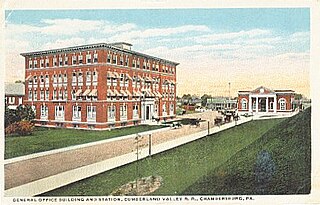
The Cumberland Valley Railroad was an early railroad in Pennsylvania, United States, originally chartered in 1831 to connect with Pennsylvania's Main Line of Public Works. Freight and passenger service in the Cumberland Valley in south central Pennsylvania from near Harrisburg to Chambersburg began in 1837, with service later extended to Hagerstown, Maryland, and then extending into the Shenandoah Valley to Winchester, Virginia. It employed up to 1,800 workers.
The Lebanon Valley is a geographic region that lies between South Mountain and the Ridge and Valley Province of eastern Pennsylvania. The valley lies almost entirely within Lebanon and Berks counties in Pennsylvania. Portions of the valley lie in eastern Dauphin and northern Lancaster counties in Pennsylvania. It is bound to its southwest by the Susquehanna River and to its northeast by the adjoining Lehigh Valley.
Hagerstown Valley is located in Maryland in the United States. It is part of the Great Appalachian Valley, which continues northward as Cumberland Valley in Pennsylvania, and southward as Shenandoah Valley in West Virginia and Virginia.
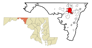
Hagerstown is a city in and the county seat of Washington County, Maryland, United States. The population was 43,527 at the 2020 census. Hagerstown ranks as Maryland's sixth-most populous incorporated city and is the most populous city in the Maryland Panhandle.

The Appalachian region has always had to allocate much resources and time into transportation due to the region's notable and unique geography. Mountainous terrain and commonly occurring adverse weather effects such as heavy fog and snowfall made roads hazardous and taxing on the traveling vehicles. Initially, European settlers found gaps in the mountains, among them the Cumberland Gap and the Wilderness Road. Another notable challenge of Appalachian travel is the political elements of constructing transportation routes. Most travel systems are funded by municipalities, but since The Appalachian area has several different states it can be difficult for the various governments to agree on how to work on transportation. The most influential forms of travel in the Appalachian region are based on water trading routes, roads and railroads.

The South Mountain Railroad was a southcentral Pennsylvania railway line for "connecting the Pine Grove works to the Cumberland Valley R. R." and which provided mining and passenger services via a southwest section from Hunter's Run, Pennsylvania, and a northern section from Hunter's Run to the CVRR junction northeast of Carlisle. The northern section merged with the Gettysburg & Harrisburg Railroad line south from Hunter's Run to the Gettysburg Battlefield in 1891 to create the Gettysburg & Harrisburg Railway line, while the branch southwest from Hunter's Run became the Hunter's Run and Slate Belt Railroad line.
The gaps of the Allegheny, meaning gaps in the Allegheny Ridge in west-central Pennsylvania, is a series of escarpment eroding water gaps along the saddle between two higher barrier ridge-lines in the eastern face atop the Allegheny Ridge or Allegheny Front escarpment. The front extends south through Western Maryland and forms much of the border between Virginia and West Virginia, in part explaining the difference in cultures between those two post-Civil War states. While not totally impenetrable to daring and energetic travelers on foot, passing the front outside of the water gaps with even sure footed mules was nearly impossible without navigating terrain where climbing was necessary on slopes even burros would find extremely difficult.