The Chesapeake Bay is the largest estuary in the United States. The bay is located in the Mid-Atlantic region and is primarily separated from the Atlantic Ocean by the Delmarva Peninsula, including parts of the Eastern Shore of Maryland, the Eastern Shore of Virginia, and the state of Delaware. The mouth of the bay at its southern point is located between Cape Henry and Cape Charles. With its northern portion in Maryland and the southern part in Virginia, the Chesapeake Bay is a very important feature for the ecology and economy of those two states, as well as others surrounding within its watershed. More than 150 major rivers and streams flow into the bay's 64,299-square-mile (166,534 km2) drainage basin, which covers parts of six states and all of Washington, D.C.

The Delmarva Peninsula, or simply Delmarva, is a peninsula on the East Coast of the United States, occupied by the majority of the state of Delaware and parts of the Eastern Shore of Maryland and Eastern Shore of Virginia.

The East Coast of the United States, also known as the Eastern Seaboard, the Atlantic Coast, and the Atlantic Seaboard, is the region encompassing the coastline where the Eastern United States meets the Atlantic Ocean. The Thirteen Colonies, which formed the United States in 1776 were located on this coast, and it has played an important role in the development of the United States.

Hampton Roads is the name of a body of water in the United States that serves as a wide channel for the James, Nansemond, and Elizabeth rivers between Old Point Comfort and Sewell's Point near where the Chesapeake Bay flows into the Atlantic Ocean. It also gave its name to the surrounding metropolitan region located in the southeastern Virginia and northeastern North Carolina portions of the Tidewater Region.

U.S. Route 13 or U.S. Highway 13 (US 13) is a north–south United States Numbered Highway established in 1926 that runs for 518 miles (834 km) from Interstate 95 (I-95) just north of Fayetteville, North Carolina, to US 1 in the northeastern suburbs of Philadelphia, Pennsylvania, near Morrisville. In all, it traverses five states in the Atlantic coastal plain region. It follows the Atlantic coast more closely than does the main north–south U.S. Highway of the region, US 1. Because of this, its number is out of place on the general U.S. Highway numbering grid, as it should be running west of US 11 but does not. Its routing is largely rural, the notable exceptions being the Hampton Roads area in Virginia and the northern end of the highway in Delaware and Pennsylvania. It is also notable for being the main thoroughfare for the Delmarva Peninsula and carrying the Chesapeake Bay Bridge–Tunnel to it in Virginia.

The Chesapeake Bay Bridge–Tunnel is a 17.6-mile (28.3 km) bridge–tunnel that crosses the mouth of the Chesapeake Bay between Delmarva and Hampton Roads in the U.S. state of Virginia. It opened in 1964, replacing ferries that had operated since the 1930s. A major project to dualize its bridges was completed in 1999, and in 2017 a similar project was started to dualize one of its tunnels.

South Hampton Roads is a region located in the extreme southeastern portion of Virginia's Tidewater region in the United States with a total population of 1,177,742 as of 2020. It is part of the Virginia Beach-Norfolk-Newport News, VA-NC MSA, which itself has a population of 1,780,059 as of 2020.

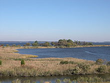
The Eastern Shore of Maryland is a part of the U.S. state of Maryland that lies mostly on the east side of the Chesapeake Bay. Nine counties are normally included in the region. The Eastern Shore is part of the larger Delmarva Peninsula that Maryland shares with Delaware and Virginia.
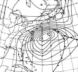
The Ash Wednesday Storm of 1962 occurred on March 5–9, 1962 along the mid-Atlantic coast of the United States. Also known as the Great March Storm of 1962, it was considered by the U.S. Geological Survey to be one of the most destructive storms ever to affect the mid-Atlantic states. Classified as a level 5 or Extreme Nor'easter by the Dolan-Davis scale for classification of Atlantic Nor'easters it was one of the ten worst storms in the United States in the 20th century. It lingered through five high tides over a three-day period, killing 40 people, injuring over 1,000, and causing hundreds of millions in property damage in six states. The storm also deposited significant snowfall over the Southeast, with a regional snowfall index of 12.663.

Transportation in the Commonwealth of Virginia is by land, sea and air. Virginia's extensive network of highways and railroads were developed and built over a period almost 400 years, beginning almost immediately after the founding of Jamestown in 1607, and often incorporating old established trails of the Native Americans.
High Tider, Hoi Toider, or Hoi Toide English is a family or continuum of American English dialects spoken in very limited communities of the South Atlantic United States, particularly several small islands and coastal townships. The exact areas include the rural "Down East" region of North Carolina, which encompasses the Outer Banks and Pamlico Sound—specifically Ocracoke, Atlantic, Davis, Sea Level, and Harkers Island in eastern Carteret County, and the village of Wanchese—plus the Chesapeake Bay, such as Smith Island in Maryland, as well as Guinea Neck and Tangier Island in Virginia. The High Tider sound has been observed as far west as Bertie County, North Carolina; the term is also a local nickname for any native-speaking resident of the relevant North Carolina region.

The Atlantic Flyway is a major north-south flyway for migratory birds in North America. The route generally starts in Greenland, then follows the Atlantic coast of Canada, then south down the Atlantic Coast of the United States to the tropical areas of South America and the Caribbean. Every year, migratory birds travel up and down this route following food sources, heading to breeding grounds, or traveling to overwintering sites.

U.S. Route 60 (US 60) in the Commonwealth of Virginia runs 303 miles (488 km) west to east through the central part of the state, generally close to and paralleling the Interstate 64 corridor, except for the crossing of the Blue Ridge Mountains, and in the South Hampton Roads area.
Older Southern American English is a diverse set of English dialects of the Southern United States spoken most widely up until the American Civil War of the 1860s, gradually transforming among its White speakers—possibly first due to postwar economy-driven migrations—up until the mid-20th century. By then, these local dialects had largely consolidated into, or been replaced by, a more regionally unified Southern American English. Meanwhile, among Black Southerners, these dialects transformed into a fairly stable African-American Vernacular English, now spoken nationwide among Black people. Certain features unique to older Southern U.S. English persist today, like non-rhoticity, though typically only among Black speakers or among very localized White speakers.
The U.S. state of Maryland has a varied geography. It has an area of 12,406.68 square miles (32,133.2 km2) and is comparable in overall area with Belgium [11,787 square miles (30,530 km2)]. It is the 42nd largest and 9th smallest state and is closest in size to the state of Hawaii, the next smallest state. The next largest state, its neighbor West Virginia, is almost twice the size of Maryland. Maryland borders Pennsylvania to the north, Delaware to the northeast, the Atlantic Ocean to the east, and to the west and south by West Virginia and Virginia.

The natural environment of Virginia encompasses the physical geography and biology of the U.S. state of Virginia. Virginia has a total area of 42,774.2 square miles (110,784.67 km2), including 3,180.13 square miles (8,236.5 km2) of water, making it the 35th-largest state by area. Forests cover 65% of the state, wetlands and water cover 6% of the land in the state, while 5% of the state is a mixture of commercial, residential, and transitional.
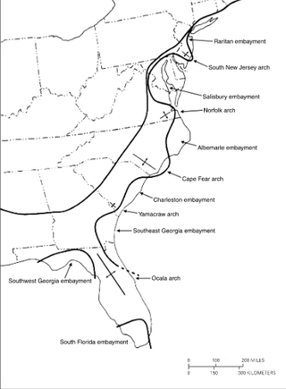
The Salisbury Embayment was an arm of the Atlantic Ocean which covered what is now Delaware, southern and eastern Maryland, the Virginia Peninsula and parts of southern New Jersey during Paleogene and Neogene times, from about 65 million to 5 million years ago. Sea level throughout most of this period stood several hundred feet higher than at present, and deposition of sediments draining off the continent possibly caused the underlying rocks to sink down, creating the embayment. The shore of the embayment lay inland at the present-day Fall Line in the region. Throughout the Paleogene and Neogene times, sediment accumulated on the floor of the Salisbury Embayment during pulses of high sea level, forming the Paleocene Aquia and Brightseat Formations, the Eocene Pamunkey Group, and the Miocene Chesapeake Group. There are no deposits from the Oligocene epoch due to a drop in sea level, however, a 2- to 3- mile diameter meteorite or asteroid is thought to have left a 50-mile diameter crater upon impact in the southern Chesapeake Bay.
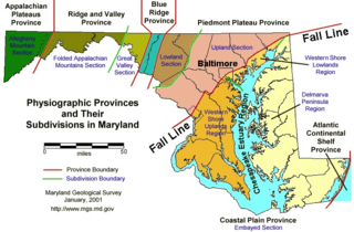
The Atlantic Seaboard Fall Line, or Fall Zone, is a 900-mile (1,400 km) escarpment where the Piedmont and Atlantic coastal plain meet in the eastern United States. Much of the Atlantic Seaboard fall line passes through areas where no evidence of faulting is present.