Caldwell County | |
---|---|
Nickname: The Gateway To The Blue Ridge | |
Coordinates: 35°58′N81°31′W / 35.97°N 81.51°W | |
Country | United States |
State | North Carolina |
Founded | 1841 |
Named for | Joseph Caldwell |
Seat | Lenoir |
Largest community | Lenoir |
Area | |
• Total | 474.61 sq mi (1,229.2 km2) |
• Land | 471.89 sq mi (1,222.2 km2) |
• Water | 2.72 sq mi (7.0 km2) 0.57% |
Population (2020) | |
• Total | 80,652 |
• Estimate (2023) | 80,574 |
• Density | 170.91/sq mi (65.99/km2) |
Time zone | UTC−5 (Eastern) |
• Summer (DST) | UTC−4 (EDT) |
Congressional districts | 5th, 10th |
Website | www |
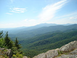
Caldwell County is a county in the U.S. state of North Carolina. It is located in the foothills of the Blue Ridge Mountains. As of the 2020 census, the population was 80,652. [1] Its county seat is Lenoir. [2] Caldwell County is part of the Hickory-Lenoir-Morganton, NC Metropolitan Statistical Area.
The county was formed in 1841 from parts of Burke County and Wilkes County. It was named for Joseph Caldwell, presiding professor and the first president of the University of North Carolina at Chapel Hill.
A series of reductions to the county's territory have taken place since its initial formation. In 1847, parts of Caldwell County, Iredell County, and Wilkes County were combined to form Alexander County. In 1849, parts of Caldwell County, Ashe County, Wilkes County, and Yancey County were combined to form Watauga County. In 1861, parts of Caldwell County, Burke County, McDowell County, Watauga County, and Yancey County were combined to form Mitchell County. Finally, in 1911 parts of Caldwell County, Mitchell County, and Watauga County were combined to form Avery County.
According to the U.S. Census Bureau, the county has a total area of 474.61 square miles (1,229.2 km2), of which 471.89 square miles (1,222.2 km2) is land and 2.72 square miles (7.0 km2) (0.57%) is water. [3]
Caldwell County is divided into three distinct geographic sections: the Blue Ridge Mountains, which dominate the northern and western parts of the county; the gently rolling Piedmont country in the middle and southern parts of the county; and the Brushy Mountains, an isolated remnant of the Blue Ridge Mountains. The "Brushies", as they are often called, run across much of Caldwell County's eastern section. Hibriten Mountain, located within the city limits of Lenoir, the county's largest city, marks the western end of the Brushy Mountain range. In the western part of the county is the Wilson Creek area.
Census | Pop. | Note | %± |
---|---|---|---|
1850 | 6,317 | — | |
1860 | 7,497 | 18.7% | |
1870 | 8,476 | 13.1% | |
1880 | 10,291 | 21.4% | |
1890 | 12,298 | 19.5% | |
1900 | 15,694 | 27.6% | |
1910 | 20,579 | 31.1% | |
1920 | 19,984 | −2.9% | |
1930 | 28,016 | 40.2% | |
1940 | 35,795 | 27.8% | |
1950 | 43,352 | 21.1% | |
1960 | 49,552 | 14.3% | |
1970 | 56,699 | 14.4% | |
1980 | 67,746 | 19.5% | |
1990 | 70,709 | 4.4% | |
2000 | 77,415 | 9.5% | |
2010 | 83,029 | 7.3% | |
2020 | 80,652 | −2.9% | |
2023 (est.) | 80,574 | [1] | −0.1% |
U.S. Decennial Census [7] 1790–1960 [8] 1900–1990 [9] 1990–2000 [10] 2010 [11] 2020 [1] |
Race | Number | Percentage |
---|---|---|
White (non-Hispanic) | 67,868 | 84.15% |
Black or African American (non-Hispanic) | 3,843 | 4.76% |
Native American | 196 | 0.24% |
Asian | 527 | 0.65% |
Pacific Islander | 15 | 0.02% |
Other/Mixed | 3,280 | 4.07% |
Hispanic or Latino | 4,923 | 6.1% |
As of the 2020 census, there were 80,652 people, 32,513 households, and 20,975 families residing in the county.
At the 2010 census, [13] there were 83,029 people, 33,388 households, and 23,456 families residing in the county. The population density was 176.1 people per square mile (68.0 people/km2). There were 37,659 housing units at an average density of 79.9 units per square mile (30.8 units/km2). The racial makeup of the county was 90.24% White, 4.92% Black or African American, 0.52% Asian, 0.31% Native American, 0.03% Pacific Islander, 2.47% from other races, and 1.51% from two or more races. The Hispanic or Latino (of any race) population was 4.57%.
There were 33,388 households, of which 32.40% had children under the age of 18 living with them, 52.16% were married couples living together, 12.52% had a female householder with no husband present, and 29.75% were non-families. 25.39% of all households were made up of individuals living alone, and 41.16% of those households had someone living alone who was 65 years of age or older. The average household size was 2.46 and the average family size was 2.91.
Of the county's entire population, 22.63% was under the age of 18, 18.33% were 18 to 34, 22.44% were 35 to 49, 21.17% were 50 to 64, and 15.44% were 65 years of age or older. The median age was 41.3 years. For every 100 females there were 96.84 males. For every 100 females age 18 and over, there were 95.06 males.
The median income for a household in the county was $34,853, and the median income for a family was $47,028. Males had a median income of $36,429 versus $31,221 for females. The per capita income for the county was $19,397. About 15.3% of families and 20.50% of the population were below the poverty line, including 51.8% of single mothers and 13.2% of people age 65 or over.
The county is governed by a five-member Board of Commissioners. [14] The members of the Board of Commissioners are Jeff Branch, Randy Church, Mike LaBrose, Donnie Potter, and Robbie Wilkie. [14] The Clerk to the Board is Abby Rich. [14] The County Manager is Donald E. Duncan Jr. and Deputy County Manager is Jimmy Harrison. [15] The Caldwell County Sheriff is Alan C. Jones. [16] The Clerk of Superior Court is Angela Ashley Kidd. [17] The county's Register of Deeds is Wayne Rash. [18] Caldwell County is a member of the regional Western Piedmont Council of Governments. [19]
In the North Carolina General Assembly, the county is represented by Republican Warren Daniel in the North Carolina Senate, as part of North Carolina Senate district 46, and by Republican Destin Hall in the North Carolina House of Representatives, as North Carolina House district 87. [20] [21]
Caldwell County is part of North Carolina's 5th congressional district in the United States House of Representatives and is represented by Republican Virginia Foxx. The county was moved from North Carolina's 11th congressional district in 2021 due to court ordered redistricting in North Carolina. North Carolina's congressional districts for 2023 and beyond have not yet been approved. [22] [23] [24] [25]
Caldwell County's partisan lean is very Republican. Of the county's elected legislative representatives at the county, state, and national level, all are Republicans. Since 2010, the average federal election vote in Caldwell County goes over 70% Republican. [26] [27] [28] [29] [30]
Year | Republican | Democratic | Third party(ies) | |||
---|---|---|---|---|---|---|
No. | % | No. | % | No. | % | |
2024 | 33,009 | 75.81% | 10,146 | 23.30% | 385 | 0.88% |
2020 | 32,119 | 74.99% | 10,245 | 23.92% | 465 | 1.09% |
2016 | 26,621 | 73.30% | 8,425 | 23.20% | 1,274 | 3.51% |
2012 | 23,229 | 66.88% | 10,898 | 31.38% | 605 | 1.74% |
2008 | 22,526 | 64.08% | 12,081 | 34.36% | 548 | 1.56% |
2004 | 21,186 | 67.58% | 9,999 | 31.90% | 163 | 0.52% |
2000 | 17,337 | 66.39% | 8,588 | 32.89% | 190 | 0.73% |
1996 | 12,653 | 55.18% | 8,050 | 35.11% | 2,228 | 9.72% |
1992 | 12,543 | 49.04% | 9,033 | 35.32% | 4,000 | 15.64% |
1988 | 15,176 | 65.78% | 7,862 | 34.08% | 33 | 0.14% |
1984 | 17,024 | 69.79% | 7,311 | 29.97% | 59 | 0.24% |
1980 | 12,965 | 58.11% | 8,738 | 39.17% | 607 | 2.72% |
1976 | 9,872 | 45.15% | 11,894 | 54.39% | 100 | 0.46% |
1972 | 12,976 | 71.41% | 4,886 | 26.89% | 309 | 1.70% |
1968 | 10,433 | 51.46% | 4,746 | 23.41% | 5,095 | 25.13% |
1964 | 8,733 | 44.60% | 10,846 | 55.40% | 0 | 0.00% |
1960 | 11,553 | 56.98% | 8,722 | 43.02% | 0 | 0.00% |
1956 | 10,833 | 61.22% | 6,861 | 38.78% | 0 | 0.00% |
1952 | 9,160 | 54.87% | 7,533 | 45.13% | 0 | 0.00% |
1948 | 4,987 | 46.24% | 5,033 | 46.67% | 765 | 7.09% |
1944 | 4,365 | 44.61% | 5,419 | 55.39% | 0 | 0.00% |
1940 | 3,005 | 32.18% | 6,334 | 67.82% | 0 | 0.00% |
1936 | 3,421 | 33.44% | 6,809 | 66.56% | 0 | 0.00% |
1932 | 3,750 | 40.43% | 5,479 | 59.07% | 46 | 0.50% |
1928 | 4,207 | 64.74% | 2,291 | 35.26% | 0 | 0.00% |
1924 | 2,503 | 42.59% | 3,348 | 56.97% | 26 | 0.44% |
1920 | 3,298 | 52.95% | 2,931 | 47.05% | 0 | 0.00% |
1916 | 1,659 | 49.02% | 1,725 | 50.98% | 0 | 0.00% |
1912 | 482 | 14.66% | 1,627 | 49.50% | 1,178 | 35.84% |
Townships in Caldwell County include: [34]
Yadkin County is a county located in the U.S. state of North Carolina. As of the 2020 census, the population was 37,214. Its county seat is Yadkinville. Yadkin County is included in the Winston-Salem, NC Metropolitan Statistical Area, which is also included in the Greensboro–Winston-Salem–High Point, NC Combined Statistical Area.
Wilkes County is a county located in the U.S. state of North Carolina. It is a part of the state's western mountain region. As of the 2020 census the population was 65,969. Its county seat is Wilkesboro, and its largest community is North Wilkesboro. Wilkes County comprises the North Wilkesboro, NC Micropolitan Statistical Area.
Watauga County is a county located in the U.S. state of North Carolina. As of the 2020 census, the population was 54,086. Its county seat and largest community is Boone. The county is in an exceptionally mountainous region, known as the High Country. It is the home of Appalachian State University, which has approximately 21,570 students as of Fall 2024. Watauga County comprises the Boone, NC Micropolitan Statistical Area.
Surry County is a county located in the U.S. state of North Carolina. As of the 2020 census, the population was 71,359. Its county seat is Dobson, and its largest community is Mount Airy.
Stokes County is a county located in the U.S. state of North Carolina. As of the 2020 census, the population was 44,520. Its county seat is Danbury.
Mitchell County is a county located in the U.S. state of North Carolina. As of the 2020 census, the population was 14,903. Its county seat is Bakersville.
McDowell County is a county located in the U.S. state of North Carolina. As of the 2020 census, the population was 44,578. Its county seat is Marion.
Iredell County is a county located in the U.S. state of North Carolina. As of the 2020 census, the population was 186,693. Its county seat is Statesville, and its largest community is Mooresville. The county was formed in 1788, subtracted from Rowan County. It is named for James Iredell, one of the first justices of the Supreme Court. Iredell County is included in the Charlotte-Concord-Gastonia, NC-SC Metropolitan Statistical Area, as defined by the Office of Management and Budget, with data from the U.S. Census Bureau.
Haywood County is a county located in the U.S. state of North Carolina. As of the 2020 census, the population was 62,089. The county seat and its largest community is Waynesville.
Forsyth County is a county located in the northwest Piedmont of the U.S. state of North Carolina. As of the 2020 census, the population was 382,590, making it the fourth-most populous county in North Carolina. Its county seat is Winston-Salem. Forsyth County is part of the Winston-Salem, NC, Metropolitan Statistical Area, which is also included in the Greensboro–Winston-Salem–High Point, NC, Combined Statistical Area. Portions of Forsyth County are in the Yadkin Valley wine region.
Davie County is a county located in the U.S. state of North Carolina. As of the 2020 census, the population was 42,712. Its county seat is Mocksville.
Burke County is a county located in the U.S. state of North Carolina. As of the 2020 census, its population was 87,570. Its county seat is Morganton.
Avery County is a county located in the U.S. state of North Carolina. As of the 2020 census, the population was 17,806. The county seat is Newland. The county seat was initially established in Elk Park when the county was first formed, but was moved to Newland upon completion of the courthouse in 1912. Founded in 1911, it is the youngest of North Carolina's 100 counties.
Alexander County is a county established in the U.S. state of North Carolina in 1847. As of the 2020 census, the population was 36,444. Its county seat is Taylorsville. Alexander County is part of the Hickory-Lenoir-Morganton, NC Metropolitan Statistical Area.
Gamewell is a town in Caldwell County, North Carolina, United States. The population was 4,051 at the 2010 census. It is part of the Hickory–Lenoir–Morganton Metropolitan Statistical Area.
Lenoir is a city in and the county seat of Caldwell County, North Carolina, United States. The population was 18,263 at the 2020 census. Lenoir is located in the foothills of the Blue Ridge Mountains. To the northeast are the Brushy Mountains, a spur of the Blue Ridge Mountains. Hibriten Mountain, located just east of the city limits, marks the western end of the Brushy Mountains range.
North Carolina's 10th congressional district is a congressional district in central and western North Carolina. It currently includes all of Cleveland, Gaston, Lincoln, Polk and Rutherford counties, and part of Catawba and Iredell counties. With a Cook Partisan Voting Index rating of R+22, it is the most Republican district in North Carolina.
Western North Carolina is the region of North Carolina which includes the Appalachian Mountains; it is often known geographically as the state's Mountain Region. It contains the highest mountains in the Eastern United States, with 125 peaks rising to over 5,000 feet in elevation. Mount Mitchell at 6,684 feet, is the highest peak of the Appalachian Mountains and mainland eastern North America. The population of the 23 most commonly associated counties for the region, as measured by the 2020 U.S. Census, is 1,149,405. The region accounts for approximately 11% of North Carolina's total population.
North Carolina's 5th congressional district covers the central western portion of North Carolina from the Appalachian Mountains to the western suburbs of the Piedmont Triad. The district borders Tennessee and Virginia, with the bulk of its territory in the mountains; it stretches just far enough to the east to grab its share of Forsyth County, home to most of its population.
The Hickory–Lenoir–Morganton, NC Metropolitan Statistical Area, as defined by the United States Census Bureau, is an area consisting of four counties, Catawba, Burke, Caldwell, Alexander. It is located in the Catawba Valley region of western North Carolina. Local residents often refer to the area as The Unifour, although this name is largely unknown outside of the region.