Hoke County, North Carolina

Last updated

Hoke County
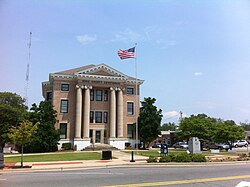
Hoke County Courthouse 2011-06.jpg
Hoke County Flag.gif
Hoke county seal nc.jpg
Hoke County Logo.jpg
Motto: 
"Where Quality Living Meets Quality of Life"
Map of North Carolina highlighting Hoke County.svg
Location within the U.S. state of North Carolina
North Carolina in United States.svg
North Carolina's location within the U.S.
Coordinates: 35°01′01″N79°14′24″W / 35.017°N 79.24°W / 35.017; -79.24
CountryFlag of the United States.svg United States
StateFlag of North Carolina.svg  North Carolina
FoundedApril 1, 1911
Named for Robert F. Hoke
Seat Raeford
Largest communityRaeford
Area
  Total
391.68 sq mi (1,014.4 km2)
  Land390.15 sq mi (1,010.5 km2)
  Water1.53 sq mi (4.0 km2)  0.39%
Population
 (2020)
  Total
52,082
  Estimate 
(2023)
54,446
  Density133.49/sq mi (51.54/km2)
Time zone UTC−5 (Eastern)
  Summer (DST) UTC−4 (EDT)
Congressional district 9th
Website www.hokecounty.net

Hoke County is a county in the U.S. state of North Carolina. As of the 2020 census, its population was 52,082. [1] Its county seat is Raeford. [2]

Contents

The county is home to part of the Fort Liberty military reservation.

History

Early history

The original inhabitants of the region eventually constituting Hoke County were Tuscarora Native Americans. [3] Ancestors of the Lumbee Native Americans lived in the area in the early 1700s. [4] European settlers began establishing church congregations in the area in the mid-to-late 1700s. [3] The area was later placed under the jurisdiction of Cumberland and Robeson counties in the U.S. state of North Carolina. [5] The community of Raeford was formed in the 1890s and incorporated in 1901. In 1899, the Aberdeen and Rockfish Railroad became the first rail line laid through the area. [3]

Creation

The county was named for Robert F. Hoke. Portrait of Robert Frederick Hoke from Biographical History of North Carolina from Colonial Times to the Present, Volume I, 1905.png
The county was named for Robert F. Hoke.

In the early 1900s, some residents in the far reaches of Cumberland and Robeson began lobbying for the creation of a new county, complaining of long and dangerous travel to their county courthouses. [6] In 1907 and 1909 there were unsuccessful efforts to lobby the state government led by State Senator J. W. McLauchlin to create a new "Glenn County" out of portions of Cumberland and Robeson. [6] [7] In 1911 a third attempt was made and conjoined with an effort to name a county in honor of Robert F. Hoke, a Confederate general in the American Civil War and railroad executive. [5]

On February 14, 1911, the North Carolina General Assembly voted to create the new Hoke County [8] effective April 1 of that year, with its first government to be appointed by the governor of North Carolina pending the holding of an election. [9] Raeford was designated the county seat, [5] and local officials served out of rented office space until a county courthouse was erected the following year. [10] At the time of its creation, Hoke County comprised about 268,000 acres of land. It had no paved roads and its economy was rooted in agriculture. Its approximately 10,000 residents were mostly white descendants of Scottish Highlanders and African Americans. [7]

Development

About 400 Hoke County residents served in the U.S. Army during World War I. [11] Between 1918 and 1923, the American federal government acquired 92,000 acres of land in the county as part of its efforts to expand Camp Bragg into Fort Bragg (now Fort Liberty). [12] leaving about 150,000 acres leftover. [7] Over 160 Hoke residents served in the armed forces during World War II. [13] After the war, the county's Lumbee population increased. [7] An effort by the U.S. Army to acquire a further 49,000 acres in the county in 1952 for Fort Bragg was abandoned after intense lobbying by local residents. In 1958, Little River Township, a section of north Hoke which was cut off from the rest of the county due to the presence of the Fort Bragg Military Reservation, was moved into the jurisdiction of Moore County. [7] Public schools, which had been originally racially segregated for whites, blacks, and Native Americans, were integrated in the 1960s. [13]

Geography

Hoke County, North Carolina
Interactive map of Hoke County

According to the U.S. Census Bureau, the county has a total area of 391.68 square miles (1,014.4 km2), of which 390.15 square miles (1,010.5 km2) is land and 1.53 square miles (4.0 km2) (0.39%) is water. [14] It is bordered by Moore, Cumberland, Robeson, Scotland, and Richmond counties. [15] Hoke lies within North Carolina's Sandhills region and Coastal Plain region. It contains several Carolina bays. [3] It drains into the Lumber River basin and Cape Fear River basin. [16] Longleaf pine is native to the region. [17]

State and local protected areas

Major water bodies

Demographics

2020 census

As of the 2020 census, there were 52,082 people residing in Hoke County, with Raeford recorded as the largest community. [28] It is a majority-minority county; [29] in the 2020 census, 40.4 percent of the community racially identified as white, 32.2 percent as black, 14.8 percent as Hispanic or Latino, 7 percent as Native American, 1.4 percent as Asian, and 0.4 percent as Native Hawaiian or Pacific Islander. [28] Hoke County is part of the Fayetteville, NC Metropolitan Statistical Area. [28] [30]

Demographic change

Hoke County's population has risen in recent decades, largely driven by expansions of Fort Liberty. [36] [37] Between 1990 and 2000, the county's population expanded by 47 percent. [38] From 2000 to 2010, the population grew from about 34,000 to over 45,000 residents. [13] Between the 2010 and 2020 censuses, the county grew by 17.8 percent, adding 5,130 residents. Proportionately, the white population shrank by 4.9 percent, while the Hispanic/Latino population expanded by 2.4 percent. [28] From 2020 to 2021, the population rose faster than the average state rate of demographic growth. [39]

Law and government

Government

Hoke County's government is seated in Raeford [5] and led by a five-person county commission. [40]

Hoke County is a member of the Lumber River Council of Governments, a regional planning board representing five counties. [41] The county also has its own Soil and Water Conservation District led by two elected supervisors. [42] The northern third of the county is a part of the Fort Liberty Military Reservation. [5] It is located in the North Carolina Senate's 24th district, and the North Carolina House of Representatives' 48th district. [42] Hoke is one of the four counties within the jurisdiction of the Lumbee Tribe of North Carolina, and tribal members within the county elect some members of the tribal council. [43]

Judicial system

Hoke County lies within the bounds of North Carolina's 29th Prosecutorial District, the 19D Superior Court District, and the 19D District Court District. [44] County voters elect a county sheriff and a clerk of Superior Court. [42]

Politics

Presidential election results
United States presidential election results for Hoke County, North Carolina [45]
Year Republican Democratic Third party(ies)
No.%No.%No.%
2024 10,54746.33%11,89652.25%3241.42%
2020 9,45343.69%11,80454.55%3821.77%
2016 7,76042.57%9,72653.35%7444.08%
2012 6,81939.90%10,07658.96%1941.14%
2008 6,29340.27%9,22759.05%1070.68%
2004 5,25747.41%5,79452.25%370.33%
2000 3,43940.07%5,01758.46%1261.47%
1996 1,91432.28%3,51059.20%5058.52%
1992 1,71127.00%3,73058.86%89614.14%
1988 2,02037.88%3,28161.52%320.60%
1984 2,44943.14%3,21456.61%140.25%
1980 1,16825.24%3,37672.95%841.82%
1976 92022.31%3,18677.27%170.41%
1972 1,92756.25%1,46642.79%330.96%
1968 81217.88%2,18548.11%1,54534.02%
1964 77925.68%2,25474.32%00.00%
1960 59622.06%2,10677.94%00.00%
1956 51320.88%1,94479.12%00.00%
1952 61625.92%1,76174.08%00.00%
1948 1428.56%1,33980.71%17810.73%
1944 1608.24%1,78291.76%00.00%
1940 1175.79%1,90494.21%00.00%
1936 1416.73%1,95393.27%00.00%
1932 653.51%1,78096.22%50.27%
1928 31121.23%1,15478.77%00.00%
1924 14110.92%1,14688.77%40.31%
1920 16611.59%1,26688.41%00.00%
1916 11012.36%78087.64%00.00%
1912 638.64%62685.87%405.49%

Hoke County is politically dominated by the Democratic Party. [46] [47] In the 2024 elections, Hoke County voters narrowly favored Democratic candidates. [48]

Economy

Turkeys in a Hoke poultry processing facility StandardLotsofTurkeysInCrates1 (4503196263).jpg
Turkeys in a Hoke poultry processing facility

Hoke County's economy was originally rooted in the lumber and turpentine industries, and over the course of the 20th century expanded to cover the cultivation of cotton and grain crops and eventually the rearing of livestock. [49] Poultry production and processing in particular grew after World War II. [50] The county has experienced economic growth in recent decades due to its proximity to Fort Liberty. [37] Poultry production remains a key part of the local economy. [36]

Transportation

County government supports a public transport bus service, the Hoke Area Transit Service. [51] Local rail transport is provided by the Aberdeen and Rockfish Railroad. [36]

Major highways

Education

Most of the county is under the public educational jurisdiction of Hoke County Schools, [53] which is governed by an elected school board. [42] A partnership with Sandhills Community College and the county created the SandHoke Early College program, which uses the community college as well as multiple middle and high schools in the county. [54] Sections in Fort Liberty are served by schools in the Department of Defense Education Activity (DoDEA), [53] for grades K-8. High school-level students living on Fort Liberty attend the local public high schools operated by the respective county they live in. [55] According to the 2021 American Community Survey, an estimated 19.8 percent of county residents have attained a bachelor's degree or higher level of education. [15]

Healthcare

Hoke County is served by two hospitals, [56] Hoke Hospital and the Hoke Campus of Moore Regional Hospital, both located in the eastern half of the county. [57] County government supports a public health department, which experienced an expanding caseload between the 2010s and early 2020s due to Hoke's demographic growth. [38]

Culture

In 1984 the county began hosting an annual festival, the Hoke Heritage Hobnob. [5] Overtime, this transformed into the North Carolina Turkey Festival and then the North Carolina Fall Festival, which celebrates turkey production in the state. [5] [58] Several area buildings and sites have been listed on the National Register of Historic Places. [59]

Communities

Map of Hoke County with municipal and township labels Map of Hoke County North Carolina With Municipal and Township Labels.PNG
Map of Hoke County with municipal and township labels

City

Census-designated places

Townships

Hoke County townships include: [60]

  • Allendale
  • Antioch
  • Blue Springs
  • McLauchlin
  • Raeford
  • Quewhiffle
  • Stonewall

See also

Related Research Articles

<span class="mw-page-title-main">Scotland County, North Carolina</span> County in North Carolina, United States

Scotland County is a county located in the southern part of the U.S. state of North Carolina. Its county seat is and largest community is Laurinburg. The county was formed in 1899 from part of Richmond County and named in honor of the Scottish settlers who occupied the area in the 1700s. As of the 2020 census, its population was 34,174.

<span class="mw-page-title-main">Robeson County, North Carolina</span> County in North Carolina, United States

Robeson County is a county in the southern part of the U.S. state of North Carolina and is its largest county by land area. Its county seat and largest community is Lumberton. The county was formed in 1787 from part of Bladen County and named in honor of Thomas Robeson, a colonel who had led Patriot forces in the area during the Revolutionary War. As of the 2020 census, the county's population was 116,530. It is a majority-minority county; its residents are approximately 38 percent Native American, 22 percent white, 22 percent black, and 10 percent Hispanic. It is included in the Fayetteville-Lumberton-Pinehurst, NC Combined Statistical Area. The state-recognized Lumbee Tribe of North Carolina is headquartered in Pembroke.

<span class="mw-page-title-main">Moore County, North Carolina</span> County in North Carolina, United States

Moore County is a county located in the U.S. state of North Carolina. As of the 2020 census, its population was 99,727. Its county seat is Carthage and its largest community Pinehurst. It is a border county between the Piedmont and the Atlantic Coastal Plain.

<span class="mw-page-title-main">Harnett County, North Carolina</span> County in North Carolina, United States

Harnett County is a county located in the U.S. state of North Carolina. As of the 2020 census, the population was 133,568. Its county seat is Lillington; its largest community is Anderson Creek. Harnett County is part of the Anderson Creek, NC Micropolitan Statistical Area.

<span class="mw-page-title-main">Cumberland County, North Carolina</span> County in North Carolina, United States

Cumberland County is a county located in the U.S. state of North Carolina. As of the 2020 census, the population was 334,728, making it the fifth-most populous county in North Carolina. Its county seat is Fayetteville. Cumberland County is part of the Fayetteville, NC Metropolitan Statistical Area.

<span class="mw-page-title-main">Bladen County, North Carolina</span> County in North Carolina, United States

Bladen County is a county located in the U.S. state of North Carolina. As of the 2020 census, the population was 29,606. Its county seat is Elizabethtown. The county was created in 1734 as Bladen Precinct and gained county status in 1739.

<span class="mw-page-title-main">Fayetteville, North Carolina</span> County seat of Cumberland County, North Carolina, United States

Fayetteville is a city in and the county seat of Cumberland County, North Carolina, United States. It is best known as the home of Fort Liberty, a major U.S. Army installation northwest of the city.

<span class="mw-page-title-main">Fort Liberty</span> CDP in North Carolina, United States

Fort Liberty, formerly Fort Bragg, is a military installation of the United States Army in North Carolina, and is one of the largest military installations in the world by population, with over 52,000 military personnel. The military reservation is located within Cumberland and Hoke counties, and borders the incorporated city and communities of Fayetteville, Spring Lake, and Southern Pines.

<span class="mw-page-title-main">Spring Lake, North Carolina</span> Town in North Carolina, United States

Spring Lake is a town in Cumberland County, North Carolina, United States. The 2010 census recorded the population at 11,964 people, with an estimated population in 2019 of 12,005.

<span class="mw-page-title-main">Ashley Heights, North Carolina</span> Census-designated place in North Carolina, United States

Ashley Heights is an unincorporated community and census-designated place (CDP) in Hoke County, North Carolina, United States. The population was 380 at the 2010 census.

<span class="mw-page-title-main">Raeford, North Carolina</span> City in North Carolina, United States

Raeford is a city in Hoke County, North Carolina, United States. Its population was 4,559 at the 2020 census. It is the county seat of Hoke County.

<span class="mw-page-title-main">Rockfish, North Carolina</span> Census-designated place in North Carolina, United States

Rockfish is a census-designated place (CDP) in Hoke County, North Carolina, United States. The population was 3,298 at the 2010 census, up from 2,353 at the 2000 census.

<span class="mw-page-title-main">Silver City, North Carolina</span> Census-designated place in North Carolina, United States

Silver City is an unincorporated area and census-designated place (CDP) in Hoke County, North Carolina in the United States. The population was 882 at the 2010 census, down from 1,146 at the 2000 census.

The Lumbee are a Native American community primarily centered in Robeson, Hoke, Cumberland, and Scotland counties in North Carolina. The Lumbee Tribe of North Carolina is a state-recognized tribe in North Carolina numbering approximately 55,000 enrolled members.

<span class="mw-page-title-main">Interstate 295 (North Carolina)</span> Highway in North Carolina

Interstate 295 (I-295), also known as the Fayetteville Outer Loop, is a partially completed Interstate-grade planned 34-mile-long (55 km) bypass around the western side of Fayetteville, North Carolina, United States. As of July 2024, it stretches for 22 miles (35 km) from US Highway 401 (US 401) in western Fayetteville to I-95 and US 13 near Eastover. The final section between US 401 and I-95 near Parkton is being constructed in segments and is expected to be completed around 2026. A 6.3-mile-long (10.1 km) segment from I-95 east of Parkton to Camden Road west of Hope Mills is signed as North Carolina Highway 295 (NC 295). NC 295 was also used as temporary designations for the highway before I-295 was signed.

Cumberland County Schools (CCS) is a school district encompassing the entirety of Cumberland County, North Carolina, United States.

<span class="mw-page-title-main">Aberdeen and Rockfish Railroad</span>

The Aberdeen and Rockfish Railroad is a short-line railroad operating in North Carolina, United States. At one time, the AR was a Class 2 railroad. The railroad has 47 miles (76 km) of track between Aberdeen and Fayetteville, North Carolina.

<span class="mw-page-title-main">Fayetteville metropolitan area, North Carolina</span> MSA consisting of three counties – Cumberland, Harnett, and Hoke – in eastern North Carolina

The Fayetteville, NC Metropolitan Statistical Area, as defined by the US Office of Management and Budget (OMB), is an area consisting of three counties – Cumberland, Harnett, and Hoke – in eastern North Carolina, anchored by the city of Fayetteville. It is served by Interstate 95, Interstate 295, U.S. and state highways, Fayetteville Regional Airport, Amtrak, Greyhound, Megabus and several railroad systems. As of the 2000 census, the MSA had a population of 336,609. As of the 2010 census the MSA had a population of 366,383. In 2011 the estimated population was 374,157. The 2019 estimated population is 526,719.

<span class="mw-page-title-main">McArthur Lake (Fort Liberty)</span> Reservoir in North Carolina, U.S.

McArthur Lake is a lake in Fort Liberty, North Carolina. It is a reservoir formed by an earth dam. The lake is used for recreational fishing.

Rockfish Creek is a 47.40 mi (76.28 km) long 5th order tributary to the Cape Fear River in Cumberland County, North Carolina.

References

  1. 1 2 3 "QuickFacts: Hoke County, North Carolina". United States Census Bureau. Retrieved March 21, 2024.
  2. "Find a County". National Association of Counties. Archived from the original on May 31, 2011. Retrieved June 7, 2011.
  3. 1 2 3 4 Monroe 2011, p. 7.
  4. Monroe 2011, p. 13.
  5. 1 2 3 4 5 6 7 8 Vocci, Robert Blair (2006). "Hoke County". NCPedia. North Carolina Government & Heritage Library. Retrieved April 13, 2022.
  6. 1 2 "Hoke County (1911)". North Carolina History Project. John Locke Foundation. 2011. Retrieved April 14, 2023.
  7. 1 2 3 4 5 Monroe 2011, p. 8.
  8. Hale, E. J. (February 22, 1911). "How Hoke County Won". Fayetteville Observer (weekly ed.). p. 4.
  9. "Hoke County April 1". Fayetteville Observer (weekly ed.). February 22, 1911. p. 4.
  10. Monroe 2011, pp. 8, 36.
  11. Monroe 2011, pp. 8–9.
  12. "They Fought Uncle Sam for us ... and won" (PDF). The News-Journal (Hoke Centennial ed.). 2011. p. 63.
  13. 1 2 3 Monroe 2011, p. 9.
  14. "2020 County Gazetteer Files – North Carolina". United States Census Bureau. August 23, 2022. Retrieved September 9, 2023.
  15. 1 2 "Hoke County, North Carolina". U.S. Census Bureau . Retrieved April 15, 2023.
  16. Bonham 2010, p. 12.
  17. Goldsmith, Thomas (August 8, 2014). "Nature, food and culture from Wake south to the other Carolina". Star-News Online. Retrieved April 25, 2023.
  18. "Calloway Forest Preserve". The Nature Conservancy. Retrieved July 27, 2022.
  19. "Hoke Community Forest". The Conservation Fund. Retrieved July 27, 2022.
  20. "NCWRC Game Lands". www.ncpaws.org. Retrieved March 30, 2023.
  21. "Stop 13: Rockfish Creek Game Land". www.visitfayettevillenc.com. Retrieved July 27, 2022.
  22. Center, Richmond Country Tourism Development Authority/ Richmond County Visitor's. "Sandhills Game Land". Richmond Country Tourism Development Authority/ Richmond County Visitor's Center. Retrieved July 18, 2022.
  23. "Army proposes to alter training simulations on Sandhills Game Land". The Laurinburg Exchange. May 21, 2019. Retrieved April 16, 2023.
  24. 1 2 3 4 5 6 7 "Final Hoke County CTP Report" (PDF). connect.ncdot.gov. April 20, 2017. p. 11. Retrieved April 15, 2023.
  25. Watson, Addison (September 7, 2022). "Trust conserves 272 acres in Hoke County". The Robesonian. Retrieved April 17, 2023.
  26. "Fishing in Little Rockfish Creek". Fishbrain. Retrieved July 27, 2022.
  27. "McArthur Lake". www.visitfayettevillenc.com. Retrieved July 27, 2022.
  28. 1 2 3 4 5 Johnson, Kristen (August 16, 2021). "Hoke, Harnett counties experienced major population growth since 2010, Census results show". The Fayetteville Observer. Archived from the original on September 25, 2021. Retrieved April 15, 2023.
  29. Tiberii, Jeff (August 29, 2022). "North Carolina's Leandro case: Everything you need to know". WUNC 91.5. WUNC North Carolina Public Radio. Retrieved December 16, 2022.
  30. "Demographics". Hoke County, North Carolina. Hoke County Government. Retrieved April 15, 2023.
  31. "U.S. Decennial Census". United States Census Bureau. Retrieved January 17, 2015.
  32. "Historical Census Browser". University of Virginia Library. Retrieved January 17, 2015.
  33. Forstall, Richard L., ed. (March 27, 1995). "Population of Counties by Decennial Census: 1900 to 1990". United States Census Bureau. Retrieved January 17, 2015.
  34. "Census 2000 PHC-T-4. Ranking Tables for Counties: 1990 and 2000" (PDF). United States Census Bureau. April 2, 2001. Archived (PDF) from the original on March 27, 2010. Retrieved January 17, 2015.
  35. "State & County QuickFacts". United States Census Bureau. Archived from the original on June 7, 2011. Retrieved October 21, 2013.
  36. 1 2 3 "Economic Development". Hoke County North Carolina. Hoke County Government. Retrieved April 14, 2023.
  37. 1 2 Barnes, Greg (March 4, 2017). "Mishandling money not new in Hoke County". The Fayetteville Observer. Retrieved April 14, 2023.
  38. 1 2 "52 Shades of Success: His Cary tech company aims to create millionaires". Triangle Business Journal. March 18, 2022. Retrieved April 15, 2023.
  39. Tippett, Rebecca (March 24, 2022). "County estimates show more deaths than births, pandemic migration". Carolina Demography. University of North Carolina at Chapel Hill. Retrieved April 14, 2023.
  40. Rash, Mebane (May 25, 2015). "The Hoke County Way: No excuses". EdNC. EducationNC. Retrieved April 16, 2023.
  41. "Richardson explains role of LRCOG to Rotary Club". The Laurinburg Exchange . January 28, 2020. Retrieved July 21, 2022.
  42. 1 2 3 4 Shepard, Catherine (November 9, 2022). "Incumbents return to commission, sheriff's office, newcomers join school board". The News-Journal. Retrieved April 13, 2023.
  43. Lowery 2018, p. 222.
  44. "Hoke County". North Carolina Judicial Branch. Retrieved April 13, 2023.
  45. Leip, David. "Dave Leip's Atlas of U.S. Presidential Elections". uselectionatlas.org. Retrieved March 15, 2018.
  46. Campbell, Colin (July 7, 2018). "GOP leaders: Voters who support House candidate not racist, just uninformed". The Herald-Sun. pp. 3A, 4A.
  47. Woolverton, Paul (January 10, 2023). "Lynnette 'Diamond' Hardaway, of Diamond and Silk, dead at 51". The Fayetteville Observer. Retrieved April 16, 2023.
  48. Shepard, Catharin (November 6, 2024). "McCollum, Leach for commission as McAllister-McRae, Brown lead for school board, Pierce and Britt back in – Hoke County voters set early turnout record". The News-Journal. Retrieved November 26, 2024.
  49. Monroe 2011, pp. 7–9.
  50. Futch, Michael (July 28, 2013). "House of Raeford shut down marks end of era for Raeford". The Fayetteville Observer. Retrieved April 15, 2023.
  51. "Hoke Area Transit Service". Hoke County, North Carolina. Hoke County Government. Retrieved April 15, 2023.
  52. 1 2 Shepard, Catharin (August 10, 2022). "Three big road projects for Hoke in state draft plan". The News-Journal. Retrieved April 17, 2023.
  53. 1 2 "2020 CENSUS - SCHOOL DISTRICT REFERENCE MAP: Hoke County, NC" (PDF). U.S. Census Bureau. Archived (PDF) from the original on July 5, 2022. Retrieved July 5, 2022. - Text list - "Fort Bragg Schools" refers to the DoDEA schools.
  54. "SandHoke Early College High School". Sandhills Community College. April 25, 2023. Retrieved April 25, 2023.
  55. "Fort Bragg/Cuba Community". Department of Defense Education Activity . Retrieved July 5, 2022.
  56. Shepard, Catharin (May 26, 2021). "County commissioners in budget talks this week". The News-Journal. Retrieved April 16, 2023.
  57. Rentz, Paige (July 11, 2015). "Hospitals have Hoke County poised for economic growth". The Fayetteville Observer. Archived from the original on April 16, 2023. Retrieved April 16, 2023.
  58. "Attractions". Hoke County, North Carolina. Hoke County Government. Retrieved April 15, 2023.
  59. "NC Listings in the National Register of Historic Places". North Carolina Department of Natural and Cultural Resources. Retrieved April 19, 2023.
  60. Powell 1976, p. 231.

Works cited