Person County, North Carolina

Last updated

Person County
Roxborocourt.jpg
Person County Flag.gif
Person County Seal.png
Person County Logo.png
Motto: 
"Everything is Better in Person"
Map of North Carolina highlighting Person County.svg
Location within the U.S. state of North Carolina
North Carolina in United States.svg
North Carolina's location within the U.S.
Coordinates: 36°23′N78°58′W / 36.39°N 78.97°W / 36.39; -78.97
CountryFlag of the United States.svg United States
StateFlag of North Carolina.svg  North Carolina
Founded1792
Named for Thomas Person
Seat Roxboro
Largest communityRoxboro
Area
  Total404.39 sq mi (1,047.4 km2)
  Land392.34 sq mi (1,016.2 km2)
  Water12.05 sq mi (31.2 km2)  2.98%
Population
 (2020)
  Total39,097
  Estimate 
(2023)
39,737
  Density99.65/sq mi (38.48/km2)
Time zone UTC−5 (Eastern)
  Summer (DST) UTC−4 (EDT)
Congressional district 4th
Website www.personcountync.gov

Person County is a county located in the U.S. state of North Carolina. The population was 39,097 as of the 2020 census. [1] The county seat is Roxboro. [2]

Contents

Person County is included in the Durham-Chapel Hill, NC Metropolitan Statistical Area, which is also included in the Raleigh-Durham-Cary, NC Combined Statistical Area, which had an estimated population of 2,368,947 in 2023. [3]

History

The colonial government established Person County as part of Edgecombe County in 1746. County designations kept changing, and it was part of Granville County from 1746 to 1752; included in Orange County until 1778; and part of Caswell County until 1791/1792. By dividing Caswell County into two squares–each side measuring approximately twenty (20) miles in length, the state formed two counties of 400 square miles (1,000 km2) each. The county was named after Brigadier General Thomas Person, a Revolutionary War patriot, who made significant contributions to Person County and surrounding areas.

The area was first inhabited by Native Americans over 10,000 years ago. The historical tribes encountered here by early Spanish explorers were generally Siouan-speaking, including the Saponi, Occaneechee, and other groups.

Settlement by immigrants of Scots, Scots-Irish, English, French Huguenot, and German ancestry began in the mid-17th and continued into the 19th centuries. [4] [5] The settlers tended to be yeoman farmers, and few owned any slaves.

Religious affiliation in the county reflects the early settlers and is predominantly Protestant. Due to Person County's nearness to Virginia, the Carolina coast, and the Appalachian foothills, a wide variety of Southern American English dialects can be heard here, including Virginia Piedmont, Coastal Southern, South Midland, and African-American English.

Revolutionary and Civil Wars

The county was named for Brigadier General Thomas Person, a Revolutionary War patriot, who made significant contributions to Person County and surrounding areas. He was a trustee of the University of North Carolina at Chapel Hill. His generous donations were recognized by the construction and naming of Person Hall.

Lieutenant Colonel Stephen Moore, Deputy Quartermaster General of the Hillsborough district, was another Revolutionary War hero, commanding the Person County militia at the disastrous Battle of Camden. He was captured and held on the prison ship Torbay. In 1775-1776 he had purchased property in the south of Person County and named his plantation Mt. Tirzah. His home, constructed in 1778, has been renovated recently. Stephen Moore was buried in the family cemetery.

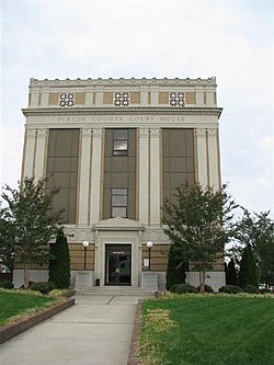
During the Civil War, Person County supplied between 800 and 1000 soldiers to the Confederate Army. A granite monument at the Courthouse honors E. Fletcher Satterfield, who carried the Confederate flag at Gettysburg.

Late 19th century

J.A. Long, W.W. Kitchin, A.R. Foushee, J.S. Bradsher, J.C. Pass, W.F. Reade, and R.E. Long were key leaders who helped make a transition to a more diversified economic base after the Civil War. The arrival of the newly constructed Norfolk and Western Railroad was a major influence around 1890, as it enabled the addition of tobacco processing plants and warehouses to the rural economy. Although the processing plants disappeared many years ago, a few of the warehouses still stand.

J.A. Long established Peoples Bank in 1891 and the Roxboro Cotton Mill in 1899, later known as Tultex Yarns. His home at Roxboro, the James A. and Laura Thompson Long House, was added to the National Register of Historic Places in 2005. [6] Long died in 1915 but was succeeded by his son, J.A. Long, Jr., who began attracting new business to Roxboro. Baker Company opened here in 1923, making textile manufacturing a major contributor to the local economy for decades. Baker was merged with Collins and Aikman Corporation (C&A), becoming a major industry in Person County for several decades before closing in August 2006. Textile manufacturers have moved to other locations in the US and overseas.

20th and 21st centuries

Residential and commercial development have grown steadily over the past few years in part due to the county's location near the Research Triangle region. The Hyco Lake area and southern portion of the county have had an influx of new home and commercial development in the late 20th and early 21st century. The county's largest employers are Duke Energy, Eaton Corporation, Georgia-Pacific Corporation and GKN Driveline.

The Holloway-Walker Dollarhite House, Henry-Vernon House, Burleigh, and Waverly Plantation are listed on the National Register of Historic Places outside Roxboro. [6]

Geography

Person County, North Carolina
Interactive map of Person County

According to the U.S. Census Bureau, the county has a total area of 404.39 square miles (1,047.4 km2), of which 392.34 square miles (1,016.2 km2) is land and 12.05 square miles (31.2 km2) (2.98%) is water. [7]

Person County contains parts of three major river basins: the Neuse, the Roanoke and the Tar, providing essential clean drinking water to the south and east of the state. The origin of the Tar River is in southeast Person County. In the northwest section of the county is Hyco Lake, with Mayo Reservoir in the northeast section. Both lakes are used for electrical power generation and recreation. Near the western border with Caswell County is Lake Roxboro. Part of the Neuse River begins here with the Flat River, where it combines with the Little and Eno rivers to go into Falls Lake and create the Neuse.

The Uwharrie Mountains, part of North Carolina's easternmost mountain range, are the oldest mountain range in North America. They are the lowest mountain range in the state. The Uwharries begin in Montgomery County and terminate at Hager's Mountain in the hills of northern Person County.

The county is largely covered by rolling hills divided by farmlands and forest. The area's ridges are not narrow and sharp like those in some parts of the Piedmont, and the gullies and ditches are not as abrupt. The northern part of the county between the lakes is skirted by a plateau. The highest point of the county is a prominent hill in Roxboro, where the county seat has located its water reservoir tank. Person County claims three small mountains. Hager's Mountain is north of Roxboro. Red Mountain and Mt. Tirzah are in the southeastern part of the county. The geology of the county is dominated by igneous formation, overlaid by a variety of soils. Granite boulders are strewn across the county.

State and local protected areas

Major water bodies

Adjacent counties

Major highways

Interstate 85 is the closest interstate highway to the county, located 29 miles south in Durham.

Major infrastructure

Raleigh-Durham International Airport, located 42 miles (68 km) south of Roxboro. Piedmont Triad International Airport, located 82 miles (132 km) southwest of Roxboro.

Demographics

Historical population
CensusPop.Note
1800 6,402
1810 6,6423.7%
1820 9,02935.9%
1830 10,02711.1%
1840 9,790−2.4%
1850 10,78110.1%
1860 11,2214.1%
1870 11,170−0.5%
1880 13,71922.8%
1890 15,15110.4%
1900 16,68510.1%
1910 17,3564.0%
1920 18,9739.3%
1930 22,03916.2%
1940 25,02913.6%
1950 24,361−2.7%
1960 26,3948.3%
1970 25,914−1.8%
1980 29,16412.5%
1990 30,1803.5%
2000 35,62318.0%
2010 39,46410.8%
2020 39,097−0.9%
2023 (est.)39,737 [1] 1.6%
U.S. Decennial Census [9]
1790–1960 [10] 1900–1990 [11]
1990–2000 [12] 2010 [13] 2020 [1]

2020 census

Person County racial composition [14]
RaceNumberPercentage
White (non-Hispanic)25,13264.28%
Black or African American (non-Hispanic)9,87925.27%
Native American 2400.61%
Asian 1240.32%
Pacific Islander 80.02%
Other/Mixed 1,5193.89%
Hispanic or Latino 2,1955.61%

As of the 2020 census, there were 39,097 people, 15,896 households, and 10,695 families residing in the county.

2010 census

At the 2010 census, [15] there were 39,464 people, 15,826 households, and 10,979 families residing in the county. The population density was 91 people per square mile (35 people/km2). There were 15,504 housing units at an average density of 40 units per square mile (15 units/km2). The racial makeup of the county was 68.1% White, 28.3% Black, 0.61% Native American, 0.15% Asian, 0.01% Pacific Islander, 1.37% from other races, and 0.86% from two or more races. Hispanic or Latino people of any race were 2.09% of the population.

There were 14,085 households, out of which 31.5% had children under the age of 18 living with them, 53.8% were married couples living together, 13.8% had a female householder with no husband present, and 28.2% were non-families. 24.2% of all households were made up of individuals, and 10.1% had someone living alone who was 65 years of age or older. The average household size was 2.50 and the average family size was 2.95.

In the county, the population was spread out, with 24.0% under the age of 18, 7.4% from 18 to 24, 30.6% from 25 to 44, 24.2% from 45 to 64, and 13.3% who were 65 years of age or older. The median age was 38 years. For every 100 females there were 93.2 males. For every 100 females age 18 and over, there were 90.2 males.

The median income for a household in the county was $42,559 and the median income for a family was $54,474. Males had a median income of $30,970 versus $22,804 for females. The per capita income for the county was $22,189. About 9.4% of families and 12.0% of the population were below the poverty line, including 14.9% of those under age 18 and 17.3% of those age 65 or over.

Law, government, and politics

Person County is a member of the Kerr-Tar Regional Council of Governments. The county government is administered by an elected county commission, and county law enforcement is administered by an elected sheriff and his officers. The county is politically conservative and Republican. No Democratic presidential candidate has carried Person County since Jimmy Carter in 1980. Before being won by George Wallace in 1968, Person County had been part of the Democratic "Solid South", voting Democrat in most elections between 1880 and 1964, except the elections in 1892 and 1908, with six consecutive Democratic presidential nominees receiving seventy-five percent of the county's vote between 1932 and 1952.

United States presidential election results for Person County, North Carolina [16]
Year Republican Democratic Third party
No.%No.%No.%
2020 13,18460.22%8,46538.66%2451.12%
2016 11,18557.02%7,83339.93%5973.04%
2012 10,49654.94%8,41844.06%1921.00%
2008 10,03053.83%8,44645.33%1560.84%
2004 8,97358.98%6,19840.74%430.28%
2000 6,72256.81%5,04242.61%690.58%
1996 4,88348.68%4,54045.26%6076.05%
1992 4,46043.60%4,32342.26%1,44714.14%
1988 4,83256.00%3,77743.78%190.22%
1984 5,85462.30%3,52837.54%150.16%
1980 3,28143.55%4,11154.57%1421.88%
1976 3,03843.20%3,97756.55%180.26%
1972 5,94171.89%2,24627.18%770.93%
1968 2,13824.17%2,64429.89%4,06545.95%
1964 2,16231.32%4,74068.68%00.00%
1960 1,92630.91%4,30569.09%00.00%
1956 1,74033.64%3,43366.36%00.00%
1952 1,37424.36%4,26675.64%00.00%
1948 48012.79%3,08782.28%1854.93%
1944 60719.49%2,50780.51%00.00%
1940 43211.77%3,23988.23%00.00%
1936 38411.70%2,89888.30%00.00%
1932 66021.65%2,37277.80%170.56%
1928 1,12347.63%1,23552.37%00.00%
1924 1,02539.36%1,57660.52%30.12%
1920 1,56648.75%1,64651.25%00.00%
1916 91749.04%95350.96%00.00%
1912 78443.85%82045.86%18410.29%

Elected officials

Elected officials in Person County (as of 2024): [17] [18] [19] [20] [21]

Economy

The economy of Person County is dominated by electrical, textile, administrative, manufacturing, aerodynamics, viticulture, brokering, food processing, automotive, aluminum and paper products. Diversification from traditional flue cured tobacco to include burley tobacco and other modes of agriculture is underway.

Person County is home to two industrial parks: Person County Business and Industrial Center (PCBIC), located on Durham Road (US 501), and North Park, located north of Roxboro on North Park Drive.

Person County is also near North Carolina's Research Triangle, home to numerous high-tech companies and enterprises.

Person County offers a strategic location for business and industry, as it is within an hour's drive of North Carolina's two major economic centers, the Research Triangle (Durham, Chapel Hill and Raleigh) and the Piedmont Triad (Greensboro, Winston-Salem and High Point), and within a two-hour drive of Richmond, Virginia.

Healthcare

Education

Higher education

Public education

Person County School System

Public education is provided by the Person County School System and administers a single unified school district with a K-12 program. As of fiscal 2018–2019, the school system consists of:

  • 4,364 students
  • 555+ staff
Person County schools
NamePrincipal/DirectorMascotColorsEnrollment
as of 2021-2022
Earl Bradsher Pre-School Center (Pre-K)Treco Lea-Jeffers, DirectorShining Stars186
Early Intervention & Family Services (Pre-K)Dana Faulkner, Director
Helena Elementary (K-5)Sherita Fuller, PrincipalHornetsBlack, yellow500
North Elementary (K-5) / Carolina Community AcademyNell Sydnor-Waugh / Renee Carmon, PrincipalEaglesRed, gold, orange217
North End Elementary (K-5)Melody Wilson, PrincipalJetsRed, blue179
Oak Lane Elementary (K-5)Heather Bowling, PrincipalCougarsGreen, white223
Stories Creek Elementary (K-5)Dusty Martin, PrincipalGatorsGreen, yellow377
South Elementary (K-5)Whitney Sharlow, PrincipalShooting StarsOrange, yellow356
Woodland Elementary (K-5)Dwayne Johnson, PrincipalLakersBlue, white213
Northern Middle (6-8)Ashley Warren, PrincipalRaidersPurple, blue, black418
Southern Middle (6-8)Patrick Holmes, PrincipalPanthersBlue, white485
Person High (9-12)Michelle Honeycutt, PrincipalRocketsBlue, white, cardinal1,080
Person County Learning Academy (6-10)Rhonda Daye, Director50
Person County Schools Virtual Academy (4-12)Dr. Tisha Duncan, Principal134
Person Early College for Innovation & LeadershipShirlrona Johnson, PrincipalMavericksGreen, White, Orange151

Charter schools

The State of North Carolina also provides for a certain number of charter schools. These are administered separately from the Person County School System. Roxboro has two charter schools:

  • Bethel Hill Charter School, an alternative public school that offers young kids an alternative for grades K–5, opened for the 2000–2001 school year. Previously the school served up to grade 6. However, it was eliminated starting in the 2016–17 school year. Total enrollment is 385.
  • Roxboro Community School, an alternative to the state public school system, is located in uptown Roxboro. It is housed in the historic Roxboro Cotton Mill/Tultex building, which is on the National Register of Historic Places. The school opened for the 2006–2007 school year. Currently serves grades 6–12. Total enrollment is 700.

Private education

Communities

Map of Person County with municipal and township labels Map of Person County North Carolina With Municipal and Township Labels.PNG
Map of Person County with municipal and township labels

City

Census-designated place

Townships

  • Allensville
  • Bushy Fork
  • Cunningham
  • Flat River
  • Holloway
  • Mount Tirzah
  • Olive Hill
  • Roxboro
  • Woodsdale

Unincorporated communities

Notable people

See also

Related Research Articles

<span class="mw-page-title-main">Montgomery County, North Carolina</span> County in North Carolina, United States

Montgomery County is a rural county located in the southern Piedmont of the U.S. state of North Carolina. As of the 2020 census, the population was 25,751. Its county seat is Troy.

<span class="mw-page-title-main">Wake County, North Carolina</span> County in North Carolina, United States

Wake County is located in the U.S. state of North Carolina. As of the 2020 census, its population was 1,129,410, making it North Carolina's most populous county. From July 2005 to July 2006, Wake County was the 9th-fastest growing county in the United States, with Cary and Raleigh being the 8th- and 15th-fastest growing communities, respectively.

<span class="mw-page-title-main">Stokes County, North Carolina</span> County in North Carolina, United States

Stokes County is a county located in the U.S. state of North Carolina. As of the 2020 census, the population was 44,520. Its county seat is Danbury.

<span class="mw-page-title-main">Randolph County, North Carolina</span> County in North Carolina, United States

Randolph County is a county located in the U.S. state of North Carolina. As of the 2020 census, the population was 144,171. Its county seat is Asheboro.

<span class="mw-page-title-main">Orange County, North Carolina</span> County in North Carolina, United States

Orange County is a county located in the Piedmont region of the U.S. state of North Carolina. As of the 2020 census, the population was 148,696. Its county seat is Hillsborough.

<span class="mw-page-title-main">Lenoir County, North Carolina</span> County in North Carolina, United States

Lenoir County is a county in the U.S. state of North Carolina. As of the 2020 census, its population was 55,122. Its county seat is Kinston, located on the Neuse River, across which the county has its territory.

<span class="mw-page-title-main">Johnston County, North Carolina</span> County in North Carolina, United States

Johnston County is a county located in the U.S. state of North Carolina. As of the 2020 census, the population was 215,999. Its county seat is Smithfield.

<span class="mw-page-title-main">Granville County, North Carolina</span> County in North Carolina, United States

Granville County is a county located on the northern border of the U.S. state of North Carolina. As of the 2020 census, the population was 60,992. Its county seat is Oxford. The county has access to Kerr Lake and Falls Lake and is part of the Roanoke, Tar and Neuse River watersheds.

<span class="mw-page-title-main">Durham County, North Carolina</span> County in North Carolina, United States

Durham County is a county located in the U.S. state of North Carolina. As of the 2020 census, the population was 324,833, making it the sixth-most populous county in North Carolina. Its county seat is Durham, which is the only incorporated municipality predominantly in the county, though very small portions of cities and towns mostly in neighboring counties also extend into Durham County. The central and southern parts of Durham County are highly urban, consisting of the city as well as several unincorporated suburbs. Southeastern Durham County is dominated by the Research Triangle Park, most of which is in Durham County. The northern third of Durham County is rural in nature.

<span class="mw-page-title-main">Davidson County, North Carolina</span> County in North Carolina, United States

Davidson County is a county located in the U.S. state of North Carolina. As of the 2020 census, the population was 168,930. Its county seat is Lexington, and its largest community is Thomasville.

<span class="mw-page-title-main">Chatham County, North Carolina</span> County in North Carolina, United States

Chatham County is a county located in the Piedmont area of the U.S. state of North Carolina. It is also the location of the geographic center of North Carolina, northwest of Sanford. As of the 2020 census, the population was 76,285. Its county seat is Pittsboro.

<span class="mw-page-title-main">Catawba County, North Carolina</span> County in North Carolina, United States

Catawba County is a county in the U.S. state of North Carolina. As of the 2020 census, the population was 160,610. Its county seat is Newton, and its largest community is Hickory.

<span class="mw-page-title-main">Caswell County, North Carolina</span> County in North Carolina, United States

Caswell County is a county in the U.S. state of North Carolina. It is located in the Piedmont Triad region of the state. At the 2020 census, the population was 22,736. Its county seat is Yanceyville.

<span class="mw-page-title-main">Caldwell County, North Carolina</span> County in North Carolina, United States

Caldwell County is a county in the U.S. state of North Carolina. It is located in the foothills of the Blue Ridge Mountains. As of the 2020 census, the population was 80,652. Its county seat is Lenoir. Caldwell County is part of the Hickory-Lenoir-Morganton, NC Metropolitan Statistical Area.

<span class="mw-page-title-main">Alamance County, North Carolina</span> County in North Carolina, United States

Alamance County is a county in North Carolina. As of the 2020 census, the population was 171,415. Its county seat is Graham. Formed in 1849 from Orange County to the east, Alamance County has been the site of significant historical events, textile manufacturing, and agriculture.

<span class="mw-page-title-main">Yanceyville, North Carolina</span> Town in North Carolina, United States

Yanceyville is a town in and the county seat of Caswell County, North Carolina, United States. Located in the Piedmont Triad region of the state, the town had a population of 1,937 at the 2020 census.

<span class="mw-page-title-main">Roxboro, North Carolina</span> City in North Carolina, United States

Roxboro is a city and the county seat of Person County in the U.S. state of North Carolina. The population was 8,134 at the 2020 census. The city is 30 miles (48 km) north of Durham and is a part of the four-county Durham–Chapel Hill Metropolitan Statistical Area, which has a population of 649,903 as of the 2020 Census. The Durham–Chapel Hill MSA is a part of the larger Raleigh–Durham–Cary Combined Statistical Area, which has a population of 2,043,867 as of the 2020 Census.

<span class="mw-page-title-main">Leasburg, North Carolina</span> Community in North Carolina, US

Leasburg is a former town and the former county seat of Caswell County, North Carolina, United States. The community has a partial presence in Person County. The population was 1,662 at the 2010 census. It was named in honor of longtime resident William Lea and is located along US 158 and NC 119 near Hyco Lake. Leasburg is also the name of a Caswell County township.

<span class="mw-page-title-main">Hyco Lake</span> Reservoir in North Carolina, United States

Hyco Lake is a reservoir in Person and Caswell counties, North Carolina. It is the area's main destination for fishing, boating, water skiing, wake boarding, and recreation and is the larger of Person County's two lakes, the other being Mayo Lake. The lake was formed from the Hyco River and has three main tributaries; North Hyco Creek, South Hyco Creek, and Cobbs Creek. Interest in the lake for vacation homes has created numerous homes along its shores with relatively high property values. Over 1500 homes have been constructed around the lake with approximately 800 occupied year-round. It runs through the following municipalities: Semora, Leasburg, and the city of Roxboro located about ten miles (16 km) from the lake.

<span class="mw-page-title-main">North Carolina Highway 57</span> State highway in North Carolina, US

North Carolina Highway 57 (NC 57) is a 43.1-mile-long (69.4 km) primary state highway in the U.S. state of North Carolina and a semi-rural traffic artery connecting Roxboro to a few small-to-medium-sized towns in The Triangle region north of the cities of Durham and Chapel Hill.

References

  1. 1 2 3 "QuickFacts: Person County, North Carolina". United States Census Bureau. Retrieved March 22, 2024.
  2. "Find a County". National Association of Counties. Retrieved June 7, 2011.
  3. "Metropolitan and Micropolitan Statistical Areas Population Totals: 2020-2023". United States Census Bureau, Population Division. March 14, 2024. Retrieved March 15, 2024.
  4. "Subscription" . search.ebscohost.com. Retrieved October 20, 2022.
  5. Carson, Scott Alan (April 2004). "European Immigration to America's Great Basin, 1850–1870". The Journal of Interdisciplinary History. 34 (4): 569–594. doi:10.1162/002219504773512543. ISSN   0022-1953.
  6. 1 2 "National Register Information System". National Register of Historic Places . National Park Service. July 9, 2010.
  7. "2020 County Gazetteer Files – North Carolina". United States Census Bureau. August 23, 2022. Retrieved September 9, 2023.
  8. 1 2 "NCWRC Game Lands". www.ncpaws.org. Retrieved March 30, 2023.
  9. "U.S. Decennial Census". United States Census Bureau. Retrieved January 18, 2015.
  10. "Historical Census Browser". University of Virginia Library. Retrieved January 18, 2015.
  11. Forstall, Richard L., ed. (March 27, 1995). "Population of Counties by Decennial Census: 1900 to 1990". United States Census Bureau. Retrieved January 18, 2015.
  12. "Census 2000 PHC-T-4. Ranking Tables for Counties: 1990 and 2000" (PDF). United States Census Bureau. April 2, 2001. Archived (PDF) from the original on March 27, 2010. Retrieved January 18, 2015.
  13. "State & County QuickFacts". United States Census Bureau. Archived from the original on June 7, 2011. Retrieved October 29, 2013.
  14. "Explore Census Data". data.census.gov. Retrieved December 22, 2021.
  15. "U.S. Census website". United States Census Bureau . Retrieved January 31, 2008.
  16. Leip, David. "Dave Leip's Atlas of U.S. Presidential Elections". uselectionatlas.org. Retrieved March 17, 2018.
  17. "Directory of Representatives". house.gov. Retrieved February 15, 2024.
  18. "Person County Representation". North Carolina General Assembly. Retrieved February 15, 2024.
  19. "Sheriff Bio". www.personcountync.gov. Retrieved February 15, 2024.
  20. "County Commissioners". www.personcountync.gov. Retrieved February 15, 2024.
  21. "Person County School District". www.pcsnc.org. Retrieved February 15, 2024.
  22. "African-American Inventors III". National Geographic Society. January 21, 2011. Retrieved March 17, 2018.