The area eventually comprising Nash County was originally organized as a part of Edgecombe County. Settlement first occurred in the 1740s;[3] the earliest land grants date to 1743.[4] As the population of Edgecombe increased, citizens in the western portion of the county found it difficult to travel to the county seat of Tarboro to conduct official business. Legislator Nathan Boddie proposed to the North Carolina Provincial Congress that the county be divided.[3] As a result, Nash was formed from all parts of Edgecombe west of the Falls of the Tar River in 1777.[5][6][7] It was named for American Revolutionary War Brigadier General Francis Nash, who was mortally wounded at the Battle of Germantown.[5] The first session of the county court met on April 1, 1778, in the home of Micajah Thomas. Court was then held in a temporary building at Peach Tree until a permanent courthouse was erected in Nashville in 1784.[7] Nashville was formally designated the seat of county government in 1815[8] and was incorporated in 1823.[9] In 1833, the county's first courthouse burned down and was replaced by a brick building.[9]
In 1786, the state of North Carolina conducted a census which recorded a total population of 5,277 in Nash County. The first U.S. Census in 1790 recorded a total population of 7,393, of whom 2,099 were slaves, 183 were free blacks, and the rest whites.[7] Several early communities in Nash County developed as stops along stagecoach routes, including Dortches, Red Oak, Stanhope, Hilliardston, and Castalia.[10] Settlement also occurred along rivers and creeks, accompanied by the construction of gristmills.[11] In the 1830s the Wilmington and Weldon Railroad was laid, leading to further settlement. The building of a spur line in 1840 led to the eventual creation of the community of Whitakers.[12] By the 1860s, Nash County had a population over 11,600 and an economy centered on agriculture.[11] In 1855, parts of Nash, Edgecombe, Johnston, and Wayne counties were combined to form Wilson County.[13] Over 1,000 men from the county fought in the American Civil War.[11]
In 1871, after significant political controversy, all parts of Edgecombe County west of the Wilmington and Weldon Railroad were annexed to Nash[14][6] leading to the bifurcation of the Edgecombe communities of Battleboro and Sharpsburg between the two counties.[6] As a result of the boundary shift, Nash County's black population grew[15] and a greater portion of the town of Rocky Mount also lay within Nash County's border, including Rocky Mount Mills, the second textile mill to exist in the state.[6] In 1899, the Atlantic Coast Line Railroad established repair shops in Rocky Mount, precipitating the city's rapid growth.[11] In 1921 the county's third courthouse was built.[9]
Geography
Interactive map of Nash County
Nash County rests in the northeastern part of North Carolina[4] along the dividing line between the Piedmont and Coastal Plain regions.[3] According to the U.S. Census Bureau, the county has a total area of 542.82 square miles (1,405.9km2), of which 540.44 square miles (1,399.7km2) is land and 2.38 square miles (6.2km2) (0.44%) is covered by water.[16] Elevation in the county gradually rises from the east to the west.[17]
As of the 2020 census, there were 94,970 people, 39,093 households, and 27,002 families residing in the county.[22]
The median age was 43.1 years. 21.5% of residents were under the age of 18 and 19.7% of residents were 65 years of age or older. For every 100 females there were 90.7 males, and for every 100 females age 18 and over there were 87.8 males age 18 and over.[22]
50.3% of residents lived in urban areas, while 49.7% lived in rural areas.[24]
Of the households, 28.6% had children under the age of 18 living in them, 42.0% were married-couple households, 18.3% were households with a male householder and no spouse or partner present, and 33.9% were households with a female householder and no spouse or partner present. About 30.6% of all households were made up of individuals and 13.9% had someone living alone who was 65 years of age or older.[22]
There were 43,154 housing units, of which 9.4% were vacant. Among occupied housing units, 63.9% were owner-occupied and 36.1% were renter-occupied. The homeowner vacancy rate was 1.2% and the rental vacancy rate was 6.6%.[22]
After decades of growth, between 2010 and 2020, Nash County recorded an almost one percent population loss.[20]
Government and politics
Government
Nash County is run by a commission–manager government. Legislative and policy-making power is vested in a seven-member board of commissioners, with the commissioners elected in districts to serve four-year staggered terms. The board passes ordinances, adopts the county budget, and appoints the county manager. The manager wields executive authority over county administration, appoints directors of county government departments, and implement the commission's decisions. County government provides various services, including public safety, social services, cultural activities, and the provision of utilities.[31]
Nash County is represented in the General Assembly by the Senate's 11th district and the House of Representatives' 24th and 25th districts.[32] It lies within the bounds of North Carolina's 8th Prosecutorial District, the 8A Superior Court District, and the 8th District Court District.[33]
From the turn of the 20th century North Carolina established barriers that effectively disfranchised the large black population, which had been supporting Republican candidates. Conservative whites voted overwhelmingly Democratic and the county and state were part of the resulting political "Solid South" county. Although it gave a plurality to Populist candidate James B. Weaver in 1892, unlike Sampson County or Alabama's Chilton County, it did not subsequently turn to the Republican Party.
Nash County would vote Democratic in every election from 1896 to 1964 – in Franklin D. Roosevelt and Harry S. Truman's five elections, the Republicans never received eleven percent of the county's limited electorate's ballots. Many whites supported George Wallace's American Independent candidacy in 1968, after passage of the Voting Rights Act. More voted Republican for the first time in 1972.
While Nash voters supported favorite son and Southern Democrat Jimmy Carter in 1976, the county's majority white voters shifted to Republican candidates from 1980 to 2004. But the last four elections have been closely contested. The margin of victory has been less than 1,000 votes in every election since.[34][35] Nash County has emerged in recent years as a swing county and a bellwether county. As of 2024, it is the only North Carolina county to support the winning U.S. presidential election four times in a row, supporting Barack Obama in 2012, Donald Trump in 2016, Joe Biden in 2020, and Trump in 2024. In 2024, it also split its majority vote between Republican and Democratic statewide candidates.[36]
United States presidential election results for Nash County, North Carolina[37]
The Sheriff's Office provides police services for the unincorporated areas of the county.
Economy
As of 2023, the biggest sectors in Nash County's economy were manufacturing, healthcare and social services, retail, food and accommodation services, and education.[38] The largest private employer is Hospira, which operates a vaccine manufacturing facility in Rocky Mount.[39]
Sweet potato harvest in Nash County
As of 2023, over 40 percent of the county's area is cultivated farmland. Its top agricultural products are poultry, eggs, tobacco, and sweet potatoes.[40] Nash is one of the top sweet potato-producing counties in the state.[40][41]
Communities
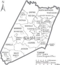
Map of Nash County with municipal and township labels
Cities
Rocky Mount (largest community; parts located in Edgecombe County)[15]
Powell, William S. (1976). The North Carolina Gazetteer: A Dictionary of Tar Heel Places. Chapel Hill: The University of North Carolina Press. ISBN978-0-8078-1247-1.
This page is based on this Wikipedia article Text is available under the CC BY-SA 4.0 license; additional terms may apply. Images, videos and audio are available under their respective licenses.