U.S. Route 258 is a spur of US 58 in the U.S. states of North Carolina and Virginia. The U.S. Highway runs 220.15 miles (354.30 km) from US 17 Business and NC 24 Business in Jacksonville, North Carolina north to Virginia State Route 143 at Fort Monroe in Hampton, Virginia. In North Carolina, US 258 connects Jacksonville with the Inner Banks communities of Kinston, Snow Hill, Farmville, Tarboro, and Murfreesboro. The U.S. Highway continues through the Virginia city of Franklin, where the highway intersects US 58, and the town of Smithfield on its way to the Hampton Roads metropolitan area. US 258 crosses the James River on the James River Bridge and follows Mercury Boulevard through Newport News and Hampton.

North Carolina Highway 226 (NC 226) is a primary state highway in the U.S. state of North Carolina. Traveling north–south through Western North Carolina, it connects the cities and towns of Grover, Shelby, Marion, Spruce Pine and Bakersville. It also a scenic byway in the South Mountains area and connects with the summer colony of Little Switzerland, via NC 226A.

North Carolina Highway 100 (NC 100) is a primary state highway in the U.S. state of North Carolina. The route travels between Whitsett and Burlington, connecting the cities of Gibsonville and Elon.

North Carolina Highway 16 (NC 16) is a primary state highway in the U.S. state of North Carolina. Traveling north–south, it connects the cities of Charlotte, Conover, Taylorsville, Wilkesboro and Jefferson; linking the Charlotte metropolitan area with the High Country. NC 16 is part of a three-state route 16 that connects the Charlotte region with northwestern West Virginia.
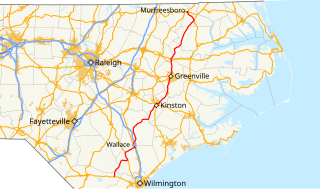
North Carolina Highway 11 (NC 11) is a primary state highway in the U.S. state of North Carolina. Traveling 193.2 miles (310.9 km) in a north–south alignment through Eastern North Carolina, it connects the towns and cities of Wallace, Kenansville, Kinston, Greenville and Murfreesboro.
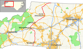
North Carolina Highway 18 (NC 18) is a primary state highway in the U.S. state of North Carolina. Traveling north–south through the Foothills region, it connects the cities of Shelby, Morganton, Lenoir, Wilkesboro and North Wilkesboro.
North Carolina Highway 42 (NC 42) is a primary state highway in the U.S. state of North Carolina and a semi-urban traffic artery connecting Asheboro, Sanford, Clayton, Wilson and Ahoskie as well as many small to medium-sized towns throughout Central and Eastern North Carolina. The highway is primarily rural, avoiding larger cities such as Raleigh. NC 42 begins at I-73/I-74/US 220 on the western side of Asheboro. From there the highway runs southeast toward Sanford. Running through the heart of Sanford, NC 42 intersects several major highways such as US 1 and US 421. Leaving Sanford the highway runs along the southern side of the Triangle Area, while servicing the smaller towns of Fuquay-Varina and Clayton. Further east the highway intersects both I-95 and US 264, shortly before entering into central Wilson. Leaving Wilson the highway continues to the northeast, and intersects US 258 near Crisp. North of intersecting US 64, NC 42 begins a concurrency with NC 11 from Hassell to western Ahoskie. Nearing Ahoskie the highway turns to the east and runs south of the center of the town. NC 42 follows concurrently with US 13 southeast to Powellsville. Nearing its eastern terminus the highway turns east along its own routing until reaching NC 45 in Colerain where the highway ends. NC 42 is the third longest state highway in the U.S. state of North Carolina.

North Carolina Highway 101 (NC 101) is a primary state highway in the U.S. state of North Carolina that serves as a shortcut for U.S. Route 70 (US 70). It links Havelock to Beaufort, bypassing Morehead City. Most of the area along NC 101 is rural with many farms and swamps.

North Carolina Highway 39 (NC 39) is a primary state highway in the U.S. state of North Carolina. Traveling north–south, it connects the cities of Selma, Louisburg and Henderson, in the Research Triangle area.

North Carolina Highway 37 (NC 37) is a primary state highway in the northeastern part of the U.S. state of North Carolina. Traveling north–south, it serves as a connector route from U.S. Route 64 (US 64) to Hertford and from US 13 to Gatesville.

North Carolina Highway 903 (NC 903) is a primary state highway in the U.S. state of North Carolina. It serves as predominantly rural highway in the Inner Banks region and arterial road in and around Greenville. The road covers a total of 200 miles (320 km), in a zigzag pattern through the state.

North Carolina Highway 94 (NC 94) is a primary state highway in the U.S. state of North Carolina. It runs from Hyde County in Swan Quarter to Chowan County near Edenton.

North Carolina Highway 111 (NC 111) is a 126.0-mile-long (202.8 km) primary state highway in the U.S. state of North Carolina. Traveling north–south through Eastern North Carolina, it connects the various rural towns and communities with the cities of Jacksonville, Goldsboro and Tarboro.
U.S. Route 13 (US 13) is a U.S. Highway running from Eastover, North Carolina to Philadelphia, Pennsylvania. In North Carolina runs along a northeast-southwest alignment for 189.1 miles (304.3 km) connecting the cities of Fayetteville, Goldsboro, Greenville, Williamston, and Ahoskie. The southern terminus is located at Interstate 95 (I-95) and I-295 near Eastover. From the terminus, US 13 travels along a northeastern-southwestern alignment through Newton Grove to US 117 in Mar-Mac. US 13 runs concurrently along US 117 north to Goldsboro, where it also shares a brief concurrency with US 70. The highway continues northeastward to Greenville and then turns to the north until reaching US 64 near Bethel. US 13 and US 64 run concurrently to the east until Williamston where US 13 diverges to the north, concurrent with US 17. In Windsor, US 13 diverges from US 17 and runs northward through Ahoskie. US 13 turns to the northeast near Winton and continues in that direction until reaching the Virginia state line near Gates, North Carolina.

North Carolina Highway 48 (NC 48) is a primary state highway in the U.S. state of North Carolina that principally connects the cities of Rocky Mount and Roanoke Rapids. The route offers an alternative to US 301 and I-95.

In the U.S. state of North Carolina U.S. Route 221 (US 221) is a north–south highway that travels through Western North Carolina. From Chesnee, South Carolina to Independence, Virginia, it connects the cities of Rutherfordton, Marion, Boone and Jefferson between the two out-of-state destinations. Its most memorable section, known as the Little Parkway Scenic Byway between Linville and Blowing Rock, offers area visitors a curvier alternative to the Blue Ridge Parkway and access to Grandfather Mountain.

North Carolina Highway 80 (NC 80) is a primary state highway in the U.S. state of North Carolina. The highway connects the various mountain communities straddled along Buck Creek, South Toe River and North Toe River in Western North Carolina and serves as a direct route, via the Blue Ridge Parkway, to Mount Mitchell State Park.

North Carolina Highway 65 (NC 65) is a primary state highway in the U.S. state of North Carolina. Traveling east–west within the Piedmont Triad, it connects the towns of Rural Hall, Walnut Cove, Stokesdale and Wentworth with the city of Reidsville.
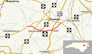
North Carolina Highway 124 (NC 124) is a primary state highway in the U.S. state of North Carolina. It serves to connect the town of Macclesfield and as an alternate to NC 42, entirely in Edgecombe County.

North Carolina Highway 305 (NC 305) is a primary state highway in the U.S. state of North Carolina. NC 305 runs from US 13 north of Windsor to NC 186 in Seaboard. NC 305 is an original state highway and appeared on the 1936 official map of North Carolina from Seaboard to Aulander. NC 305 has an average of 1663 cars per day on the highway.

