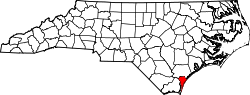
New Hanover County is a county located in the U.S. state of North Carolina. As of the 2020 census, the population was 225,702.[1] The county seat is Wilmington.[2] Though the second-smallest county in North Carolina by land area,[3] it is one of the most populous counties, as Wilmington is one of the largest communities in the state. The county was created in 1729 as New Hanover Precinct and gained county status in 1739.[4] New Hanover County is included in the Wilmington, NC Metropolitan Statistical Area, which also includes neighboring Pender and Brunswick counties.
Prior to European settlement, New Hanover county was populated by two Native American tribes, namely the Cape Fear Indians and the Waccamaw Siouan Indians. Proof of settlement dates back to roughly 8000 BC, and Natives resided intermittently in the area throughout the first millennium.[5] The first European to visit the area was the Italian-born French explorer Giovanni da Verrazano in 1524, who reported his findings back to France, which took no further action. In 1526, Spaniard Lucas Vázquez de Ayllón led an expedition to the area, wrecking a ship in the process but also moving on from the area. In 1662, a New England expedition led by captain William Hilton traveled to the area, seeking to find a more temperate climate to establish a Puritan colony. After reporting favorable findings, a group of settlers arrived in the area, naming it "Cape Fear," but they too departed shortly for unknown reasons. Repeated failures to establish a settlement led to the area being left uninhabited for another century, and even the Cape Fear Indians, decimated by war and tribal infighting, were eventually forced to leave.[6]
Finally being permanently settled in 1726, the county was formed in 1729 as New Hanover Precinct of Bath County, from Craven Precinct. It was named for the House of Hanover, a German royal family then ruling Great Britain.[7] In 1734, parts of New Hanover Precinct became Bladen Precinct and Onslow Precinct. With the abolition of Bath County in 1739, all of its constituent precincts became counties. In 1750, the northern part of New Hanover County became Duplin County. In 1764, another part of New Hanover County was combined with part of Bladen County to form Brunswick County. Finally, in 1875, the separation of northern New Hanover County to form Pender County reduced it to its present dimensions. Originally designated as one of North Carolina's five ports, the Port of Brunswick (then the county seat) quickly developed into the state's most important port. During this time, the city of Wilmington (then called Newton) was formed, quickly surpassing Brunswick as the dominant city in the county and becoming the county seat. During this time, the county developed plantations, largely for the cultivation of tobacco and other commodity crops by enslaved African Americans.[8] Despite this, the maritime nature of the county and relatively poor agricultural conditions meant that the plantation economy never managed to eclipse the trade economy.[6]
Revolutionary War and Antebellum Period
Following the French and Indian War, the English government instituted the Stamp Act in order to pay for additional security measures. Enraged, locals marched to Brunswick and placed governor William Tryon under virtual house arrest, marking one of the first major protests against the crown. In 1776, Continental Army colonel James Moore crushed Loyalist forces at the Battle of Moore's Creek Bridge, and the United States Declaration of Independence followed five months later. The British only managed to recapture Wilmington five years later, only to be bloodlessly recaptured by Americans following the surrender of General Charles Cornwallis.[6]
During the Antebellum Period, New Hanover County steadily grew in importance as the growth of interior North Carolina and the opening of trade with the Caribbean led to a surge in trade, mainly conducted from the Port of Wilmington, which had been renamed after Brunswick was depopulated. Improvements were done to the Cape Fear River in order to allow easier navigability, and the arrival of the steamboat in 1817 and the railroad in 1840 led to the explosive growth of Wilmington. By 1860, Wilmington had 4 of the 36 banks in the state.[6]
Civil War and Reconstruction
By 1860, the county seat and county were majority-black in population, with most of those people enslaved. Wilmington was of crucial importance to the Confederacy as a blockade-running center, as its port allowed supplies to be sent directly via the Wilmington and Weldon Railroad to resupply Confederate troops in the north.[6] Confederates established Fort Fisher, which was seen by both sides as second in importance only to Richmond. Some of the closing battles of the American Civil War took place in this county, including the Second Battle of Fort Fisher (the last major coastal stronghold of the Confederacy) and the Battle of Wilmington, and the fall of Wilmington marked the last days of the Confederacy.
Following the end of the war, Wilmington was placed under military rule. A new constitution granting the vote to freedmen was established in 1868, and White Democrats were resentful when freedmen were given the vote. Democrats quickly regained control of state government, and Wilmington was gerrymandered to ensure Democratic mayoralties. Following the Reconstruction era, white Democrats regained control of the state legislature. Violence by whites against blacks increased in the late 19th century, with 22 lynching deaths of African Americans recorded before the mid-20th century.[9][10]
Racial terrorism on a larger scale took place in the Wilmington Insurrection of 1898, when a group of white Democrats rejected a duly elected, biracial city government. After overthrowing the Fusionist government, the mayor and city council, they led mobs that rioted and attacked the city's black neighborhoods and residents. A total of 60 to 300 blacks are believed to have been killed in the rioting, leaders were driven out of the city, and the presses of a black-owned newspaper were destroyed, along with many houses and businesses.[11][12] Soon after, the state passed a new constitution raising barriers to voter registration: this effectively disenfranchised most blacks and imposed Jim Crow laws, destroying the political relevance of both the Black population and the Republican Party.[13]
Modern times
Wilmington's economy was decimated during Reconstruction due to the declining importance of the cotton trade, for which Wilmington had been a major port. During World War I, Wilmington got some brief respite due to the shipbuilding industry, although this was short-lived.[6] Wilmington's economy continued to stutter through the Great Depression, and World War II saw a rebound for the city's economy. The North Carolina Shipbuilding Company was established in 1941, and Wilmington became one of the nation's most crucial shipyards during the war, with its economy continuing to grow after the war had ended.[14]
The growth of America's interstate freeways and the onset of the trucking industry continued to benefit New Hanover County, and during the post-war period the large number of returning soldiers joined the newfound labor force in suburbanizing and growing the county. By the 1960s, New Hanover County had a diversified economy,[6] and historic preservation movements led to the revitalization of the county. The USS North Carolina was berthed in Wilmington as a museum ship in 1961, which led to a downtown revitalization effort and supercharged the city's tourist economy.[15] The University of North Carolina Wilmington was granted university status in 1969, and is estimated to contribute billions yearly to the county's economy.[16]
Beginning in the 1980s, the city saw an explosion in population due to the rapidly growing film industry. The establishment of De Laurentiis Entertainment Group led to a major studio presence in the county,[17] and the area is now known as "Hollywood East."[18] This growth was compounded by the construction of Interstate 40, which connected the city and its port to the rest of the country via interstate for the first time. This growth has continued into the 21st century, and was even further exacerbated by the COVID-19 pandemic, after which the county saw an influx of remote workers and retirees, while UNC Wilmington is the fastest growing campus in the UNC system.[19] New Hanover County is now nearly completely developed, and continues to rank in the top 10 North Carolinian counties for GDP growth.[20]
Geography
Interactive map of New Hanover County
Intersection of South College Road, South 17th Street, and Waltmoor Road from the airThe surf at Carolina Beach
According to the U.S. Census Bureau, the county has a total area of 328.86 square miles (851.7km2), of which 192.26 square miles (498.0km2) is land and 136.60 square miles (353.8km2) (41.54%) is water.[21] It is the second-smallest county in North Carolina by land area (ahead of only Chowan County).
New Hanover County, North Carolina – Racial and ethnic composition Note: the US Census treats Hispanic/Latino as an ethnic category. This table excludes Latinos from the racial categories and assigns them to a separate category. Hispanics/Latinos may be of any race.
As of the 2020 census, there were 225,702 people, 98,109 households, and 56,160 families residing in the county.[37]
The median age was 40.6 years. 18.4% of residents were under the age of 18 and 19.4% of residents were 65 years of age or older. For every 100 females there were 91.3 males, and for every 100 females age 18 and over there were 88.5 males age 18 and over.[37]
98.3% of residents lived in urban areas, while 1.7% lived in rural areas.[39]
There were 98,109 households in the county, of which 24.1% had children under the age of 18 living in them. Of all households, 41.9% were married-couple households, 19.6% were households with a male householder and no spouse or partner present, and 31.0% were households with a female householder and no spouse or partner present. About 31.9% of all households were made up of individuals and 12.3% had someone living alone who was 65 years of age or older.[37]
There were 113,368 housing units, of which 13.5% were vacant. Among occupied housing units, 60.1% were owner-occupied and 39.9% were renter-occupied. The homeowner vacancy rate was 1.9% and the rental vacancy rate was 11.1%.[37]
2000 census
At the 2000 census,[40] there were 160,307 people, 68,183 households, and 41,591 families residing in the county. The population density was 806 peopleper square mile (311 people/km2). There were 79,616 housing units at an average density of 400 unitsper square mile (150 units/km2). The racial makeup of the county was 79.91% White, 16.97% Black or African American, 0.39% Native American, 0.83% Asian, 0.06% Pacific Islander, 0.79% from other races, and 1.05% from two or more races. 2.04% of the population were Hispanic or Latino of any race. 14.3% were of English, 13.0% United States or American, 10.6% German and 10.2% Irish ancestry according to Census 2000.
There were 68,183 households, out of which 26.10% had children under the age of 18 living with them, 46.50% were married couples living together, 11.50% had a female householder with no husband present, and 39.00% were non-families. 28.90% of all households were made up of individuals, and 8.50% had someone living alone who was 65 years of age or older. The average household size were 2.29 and the average family size was 2.83.
In the county, the population was spread out, with 21.00% under the age of 18, 12.00% from 18 to 24, 30.50% from 25 to 44, 23.70% from 45 to 64, and 12.80% who were 65 years of age or older. The median age was 36 years. For every 100 females there were 93.30 males. For every 100 females age 18 and over, there were 90.70 males.
The median income for a household in the county was $40,172, and the median income for a family was $50,861. Males had a median income of $35,801 versus $25,305 for females. The per capita income for the county was $23,123. About 8.30% of families and 13.10% of the population were below the poverty line, including 15.70% of those under age 18 and 9.00% of those age 65 or over.
Government and politics
W. Allen Cobb Judicial Annex in WilmingtonNew Hanover County Jail and Sheriff's Office in unincorporated Castle Hayne
New Hanover County is governed by a county commission. The commission comprises five members elected at-large in four-year staggered terms. The body elects its own chairman and vice-chairman. It sets policy for county administration within the confines of state law, adopts local ordinances, appoints advisory committees, and enacts an annual county budget.[41]
New Hanover County Sheriff's Office (NHCSO) serves as the county's primary law enforcement agency. NHCSO is responsible for patrolling the county (primarily outside the Wilmington city limits), staffing the juvenile and adult correctional facilities, and proving court security for the W. Allen Cobb Judicial Annex in Wilmington.
New Hanover County is governed by a board of commissioners and has several elected office positions. The board of commissioners is elected at-large, with the top vote-getters obtaining seats.
Since formation, New Hanover and the surrounding Cape Fear region were some of the few Republican holdouts in North Carolina, largely attributed to its larger-than-average African-American population, which voted Republican at the time. Wilmington was then home to a Fusionist coalition of African-Americans and White Republicans, which gained control of the city in 1898. Following this event, a white mob overthrew the government, banishing Republicans and African-Americans from the city in what would later be known as the Wilmington massacre.[48] This began an immediate political realignment, with Democrats jumping from less than 40% of the vote to nearly 100% of the vote in one election cycle.
This continued throughout the 20th century, with Democrats maintaining a tight hold on the county for over 60 years (aside from Herbert Hoover's victory in 1928, when the heavily anti-Catholic Outer Banks region cast its votes against Catholic Al Smith[49]). In the mid-20th century, New Hanover County began shifting back towards Republicans at a faster rate than other majority-White southern counties due to its massive population increase and importance as an industrial center during World War II, and had become a swing county by the 1950s. It began to follow the shift of other southern counties, with African-Americans moving to the Democratic Party and Whites moving to the Republican Party, although its rapid growth throughout the century means it never became as solidly Republican as other rural southern counties.
Modern New Hanover County is politically competitive, and the margin of victory for either party has not gone past 5% in over 20 years.[50][51] The rapid growth of Wilmington due to its burgeoning film industry and college population has shifted the county to the left in recent years,[52] though Republicans still tend to perform better in local contests.[50]
In 2020, Joe Biden became the first Democrat to carry the county in 45 years, also becoming the first Democrat ever to win the county but lose the state. In 2024, despite her majority being reduced to a narrow plurality, Kamala Harris became the first Democratic presidential nominee to win the county yet lose the presidential election since 1956. The county voted for Democrats who lost statewide for the first time.
United States presidential election results for New Hanover County, North Carolina[53]
The county is served by New Hanover County Schools, which are governed by an elected county board of education. There are also several private schools and a catholic school.
New Hanover Regional Medical Center is a hospital in Wilmington. It was established in 1967 as a public hospital, and it was the first hospital in the city to admit patients of all races.[54] It was operated by New Hanover County.[55] In February 2021 Novant Health, a nonprofit private organization, acquired the hospital.[56]
Communities
Map of New Hanover County with municipal and township labels
↑Lennon, Donald R.; SLNC Government and Heritage Library (2006). Powell, William S. (ed.). "Cape Fear River Settlements". NCpedia. University of North Carolina Press. Retrieved October 29, 2023.
This page is based on this Wikipedia article Text is available under the CC BY-SA 4.0 license; additional terms may apply. Images, videos and audio are available under their respective licenses.