Sea Breeze, North Carolina

Last updated

Sea Breeze, North Carolina
CDP
New Hanover County North Carolina incorporated and unincorporated areas Sea Breeze highlighted.svg
Location in New Hanover County and the state of North Carolina.
Coordinates: 34°04′11″N77°53′47″W / 34.06972°N 77.89639°W / 34.06972; -77.89639
Country United States
State North Carolina
County New Hanover
Area
[1]
  Total2.09 sq mi (5.41 km2)
  Land1.86 sq mi (4.83 km2)
  Water0.23 sq mi (0.59 km2)
Elevation
[2]
13 ft (4 m)
Population
 (2020)
  Total2,245
  Density1,204.40/sq mi (465.01/km2)
Time zone UTC-5 (Eastern (EST))
  Summer (DST) UTC-4 (EDT)
FIPS code 37-60000 [3]
GNIS feature ID2402834 [2]

Sea Breeze is a census-designated place (CDP) in New Hanover County, North Carolina, United States. The population was 1,969 at the 2010 census, up from 1,312 in 2000. It is part of the Wilmington Metropolitan Statistical Area.

Contents

Geography

According to the United States Census Bureau, the CDP has a total area of 1.6 square miles (4.1 km2), all land.

Demographics

Historical population
CensusPop.Note
2020 2,245
U.S. Decennial Census [4]

As of the census [3] of 2000, there were 1,312 people, 546 households, and 407 families residing in the CDP. The population density was 806.0 inhabitants per square mile (311.2/km2). There were 643 housing units at an average density of 395.0 per square mile (152.5/km2). The racial makeup of the CDP was 81.94% White, 15.85% African American, 0.38% Native American, 0.61% Asian, 0.23% from other races, and 0.99% from two or more races. Hispanic or Latino of any race were 1.52% of the population.

There were 546 households, out of which 23.6% had children under the age of 18 living with them, 65.0% were married couples living together, 6.8% had a female householder with no husband present, and 25.3% were non-families. 19.2% of all households were made up of individuals, and 7.0% had someone living alone who was 65 years of age or older. The average household size was 2.40 and the average family size was 2.74.

In the CDP, the population was spread out, with 18.4% under the age of 18, 5.5% from 18 to 24, 25.1% from 25 to 44, 34.5% from 45 to 64, and 16.6% who were 65 years of age or older. The median age was 46 years. For every 100 females, there were 97.9 males. For every 100 females age 18 and over, there were 93.7 males.

The median income for a household in the CDP was $41,836, and the median income for a family was $46,023. Males had a median income of $32,120 versus $26,029 for females. The per capita income for the CDP was $21,608. About 13.2% of families and 14.1% of the population were below the poverty line, including 29.3% of those under age 18 and 14.0% of those age 65 or over.

Related Research Articles

<span class="mw-page-title-main">Vincent, California</span> Census-designated place in California, United States

Vincent is a census-designated place (CDP) in the central San Gabriel Valley, in Los Angeles County, California, United States. The city name and zipcode for addresses south of Arrow Highway is Covina and 91722, respectively, and Azusa and 91702 for addresses north of Arrow Highway. The population was 15,922 at the 2010 census, up from 15,097 at the 2000 census. Vincent is named after Vincent Avenue, which passes through the community.

<span class="mw-page-title-main">Tamalpais-Homestead Valley, California</span> Census-designated place in California, United States

Tamalpais-Homestead Valley is a census-designated place (CDP) in Marin County, California, United States. The population was 11,492 at the 2020 census.

<span class="mw-page-title-main">North Auburn, California</span> Census-designated place in California, United States

North Auburn is a census-designated place (CDP) in Placer County, California, United States. It is part of the Sacramento–Arden-Arcade–Roseville Metropolitan Statistical Area. The population was 13,452 at the 2020 census.

<span class="mw-page-title-main">Molino, Florida</span> Census-designated place in Florida, United States

Molino is a census-designated place (CDP) in Escambia County, Florida, United States. The population was 1,277 at the 2010 census. It is part of the Pensacola–Ferry Pass–Brent Metropolitan Statistical Area.

<span class="mw-page-title-main">Loughman, Florida</span> Census-designated place in Florida, United States

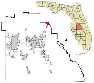
Loughman (LOFF-mǝn) is a census-designated place (CDP) in the northeast corner of Polk County, Florida, United States, near the Osceola county line. The population was 1,385 at the 2000 census. It is part of the Lakeland–Winter Haven Metropolitan Statistical Area. This area has grown rapidly since 2000 due, in large part, to its proximity to Walt Disney World and the Orlando, Florida area.

<span class="mw-page-title-main">Fairmont, Illinois</span> Census-designated place in Illinois, United States

Fairmont is a census-designated place (CDP) in Will County, Illinois, United States. The population was 2,389 at the 2020 census.

<span class="mw-page-title-main">Fountainhead-Orchard Hills, Maryland</span> CDP in Maryland, United States

Fountainhead-Orchard Hills is a census-designated place (CDP) in Washington County, Maryland, United States. The population was 3,861 at the 2000 census.

<span class="mw-page-title-main">Yarmouth Port, Massachusetts</span> Census-designated place in Massachusetts, United States

Yarmouth Port is a census-designated place (CDP) in the town of Yarmouth in Barnstable County, Massachusetts, United States. The population was 5,320 at the 2010 census.

<span class="mw-page-title-main">Lost Lake Woods, Michigan</span> Census-designated place & unincorporated community in Michigan, United States

Lost Lake Woods is an unincorporated community and census-designated place (CDP) in Alcona County in the U.S. state of Michigan. The population was 367 at the 2020 census. It is located within Alcona Township.

<span class="mw-page-title-main">Middletown, Michigan</span> Census-designated place & unincorporated community in Michigan, United States

Middletown is an unincorporated community and census-designated place (CDP) in Shiawassee County in the U.S. state of Michigan. The CDP had a population of 825 at the 2020 census. Middletown is located within Caledonia Township along M-71 between the cities of Corunna and Owosso

<span class="mw-page-title-main">Gardnerville Ranchos, Nevada</span> Census-designated place in Nevada, United States

Gardnerville Ranchos is a census-designated place in Douglas County, Nevada, United States. As of the 2010 census, the population was 11,312. The area is the namesake for the Gardnerville Ranchos Micropolitan Statistical area which includes other areas of Douglas County.

<span class="mw-page-title-main">Myers Corner, New York</span> Census-designated place in New York, United States

Myers Corner is a hamlet and census-designated place (CDP) in the town of Wappinger, Dutchess County, New York, United States. The population was 6,790 at the 2010 census. It is part of the Poughkeepsie–Newburgh–Middletown, NY Metropolitan Statistical Area as well as the larger New York–Newark–Bridgeport, NY-NJ-CT-PA Combined Statistical Area.

<span class="mw-page-title-main">West Glens Falls, New York</span> CDP and hamlet of Queensbury in New York, United States

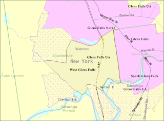
West Glens Falls is a census-designated place (CDP) and hamlet in Warren County, New York, United States. The population was 6,721 at the 2000 census. It is part of the Glens Falls Metropolitan Statistical Area.

<span class="mw-page-title-main">Conneaut Lakeshore, Pennsylvania</span> Census-designated place in Pennsylvania, United States

Conneaut Lakeshore is a census-designated place (CDP) in Crawford County, Pennsylvania, United States. The population was 2,395 at the 2010 census.

<span class="mw-page-title-main">Woodfield, South Carolina</span> Census-designated place in South Carolina, United States

Woodfield is a census-designated place (CDP) in Richland County, South Carolina, United States. The population was 9,303 at the 2010 census. It is part of the Columbia, South Carolina Metropolitan Statistical Area.

<span class="mw-page-title-main">Falcon Mesa, Texas</span> CDP in Texas, United States

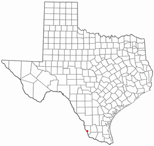
Falcon Mesa is a census-designated place (CDP) in Zapata County, Texas, United States. The population was 405 at the 2010 census.

<span class="mw-page-title-main">Leisuretowne, New Jersey</span> Populated place in Burlington County, New Jersey, US

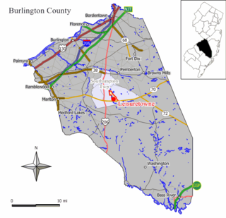
Leisuretowne is an unincorporated community and census-designated place (CDP) located within Southampton Township, in Burlington County, in the U.S. state of New Jersey. As of the 2010 United States Census, the CDP's population was 3,582.

<span class="mw-page-title-main">Parkwood, Washington</span> CDP in Washington, United States

Parkwood is a census-designated place (CDP) in Kitsap County, Washington, United States. The population was 7,126 at the 2010 census.

<span class="mw-page-title-main">Eschbach, Washington</span> CDP in Washington, United States

Eschbach is a census-designated place (CDP) in Yakima County, Washington, United States. The population was 415 at the 2010 census.

<span class="mw-page-title-main">Loveland Park, Ohio</span> Census-designated place in Ohio, United States

Loveland Park is a census-designated place (CDP) located in Symmes Township, Hamilton County and Deerfield Township, Warren County, in the southwestern part of the U.S. state of Ohio. The CDP is named after the city of Loveland. The population was 1,737 at the 2020 census.

References

  1. "ArcGIS REST Services Directory". United States Census Bureau. Retrieved September 20, 2022.
  2. 1 2 U.S. Geological Survey Geographic Names Information System: Sea Breeze, North Carolina
  3. 1 2 "U.S. Census website". United States Census Bureau . Retrieved January 31, 2008.
  4. "Census of Population and Housing". Census.gov. Retrieved June 4, 2016.