Hightsville, North Carolina

Last updated

Hightsville, North Carolina
CDP
Hightsville, North Carolina.jpg
New Hanover County North Carolina incorporated and unincorporated areas Hightsville highlighted.svg
Location in New Hanover County and the state of North Carolina.
Coordinates: 34°16′00″N77°56′04″W / 34.26667°N 77.93444°W / 34.26667; -77.93444
Country United States
State North Carolina
County New Hanover
Area
[1]
  Total1.61 sq mi (4.18 km2)
  Land1.46 sq mi (3.78 km2)
  Water0.15 sq mi (0.40 km2)
Elevation
[2]
3 ft (0.9 m)
Population
 (2020)
  Total710
  Density486.97/sq mi (188.01/km2)
Time zone UTC-5 (Eastern (EST))
  Summer (DST) UTC-4 (EDT)
ZIP code
28401 [3]
Area codes 910, 472
FIPS code 37-31490 [4]
GNIS feature ID2402585 [2]

Hightsville is a census-designated place (CDP) in New Hanover County, North Carolina, United States. The population was 739 at the 2010 census. It is part of the Wilmington Metropolitan Statistical Area.

Contents

Geography

According to the United States Census Bureau, the CDP has a total area of 1.6 square miles (4.1 km2), all land.

Demographics

Historical population
CensusPop.Note
2020 710
U.S. Decennial Census [5]

As of the census [4] of 2000, there were 759 people, 163 households, and 102 families residing in the CDP. The population density was 484.6 people per square mile (187.1 people/km2). There were 186 housing units at an average density of 118.8 per square mile (45.9/km2). The racial makeup of the CDP was 64.16% White, 33.86% African American, 0.66% Native American, 0.92% from other races, and 0.40% from two or more races. Hispanic or Latino of any race were 1.45% of the population.

There were 163 households, out of which 27.0% had children under the age of 18 living with them, 45.4% were married couples living together, 12.9% had a female householder with no husband present, and 37.4% were non-families. 31.3% of all households were made up of individuals, and 12.9% had someone living alone who was 65 years of age or older. The average household size was 2.34 and the average family size was 2.94.

In the CDP, the population was spread out, with 11.3% under the age of 18, 10.4% from 18 to 24, 50.6% from 25 to 44, 18.3% from 45 to 64, and 9.4% who were 65 years of age or older. The median age was 36 years. For every 100 females, there were 287.2 males. For every 100 females age 18 and over, there were 339.9 males.

The median income for a household in the CDP was $33,088, and the median income for a family was $42,188. Males had a median income of $27,292 versus $25,972 for females. The per capita income for the CDP was $13,458. None of the families and 3.4% of the population were living below the poverty line, including no under eighteens and 8.5% of those over 64.

Related Research Articles

<span class="mw-page-title-main">Clay, Alabama</span> City in Alabama, United States

Clay is a city in northeastern Jefferson County, Alabama, United States. It is part of the Birmingham–Hoover–Cullman Combined Statistical Area in the north-central part of the state. Local government is run by a mayor and city council.

<span class="mw-page-title-main">Kwigillingok, Alaska</span> CDP in Alaska, United States

Kwigillingok is a census-designated place (CDP) in Bethel Census Area, Alaska, United States. The population was 321 at the 2010 census, down from 338 in 2000.

<span class="mw-page-title-main">Beaver, Alaska</span> CDP in Alaska, United States

Beaver is a census-designated place (CDP) in Yukon-Koyukuk Census Area, Alaska, United States. At the 2010 census the population was 84, unchanged from 2000.

<span class="mw-page-title-main">Shongopovi, Arizona</span> CDP in Navajo County, Arizona

Shongopovi is a census-designated place (CDP) in Navajo County, Arizona, United States. It is located on the Second Mesa, within the Hopi Reservation.

<span class="mw-page-title-main">Santan, Arizona</span> CDP in Pinal County, Arizona

Santan is an unincorporated community, and former census-designated place (CDP), in Pinal County, Arizona, United States. The settlement was named "Santa Ana" by its Akimel O'odham inhabitants in 1857, and pronounced "Santana".

<span class="mw-page-title-main">North El Monte, California</span> Census-designated place in California, United States

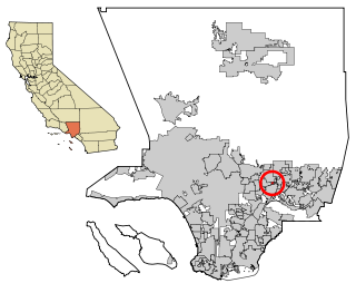
North El Monte is a census-designated place (CDP) in the San Gabriel Valley, in Los Angeles County, California, United States. The population was 3,723 at the 2010 census, up from 3,703 at the 2000 census.

<span class="mw-page-title-main">Chilcoot-Vinton, California</span> Census-designated place in California, United States

Chilcoot-Vinton is a census-designated place (CDP) in Plumas County, California, United States. The population was 454 at the 2010 census, up from 387 at the 2000 census. It consists of the communities of Chilcoot and Vinton

<span class="mw-page-title-main">Lakeview, California</span> Census-designated place in California, United States

Lakeview is a census-designated place (CDP) in Riverside County, California, United States. The population was 2,104 at the 2010 census, up from 1,619 at the 2000 census. The community is named for nearby Mystic Lake.

<span class="mw-page-title-main">Fussels Corner, Florida</span> Census-designated place in Florida, United States

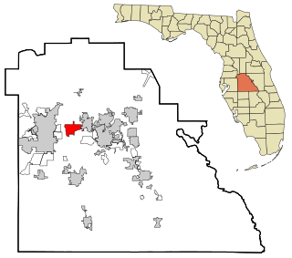
Fussels Corner is a census-designated place (CDP) in Polk County, Florida, United States. The population was 5,313 at time of the 2000 census. It is part of the Lakeland–Winter Haven Metropolitan Statistical Area.

<span class="mw-page-title-main">The Meadows, Florida</span> Census-designated place in Florida, United States

The Meadows is a census-designated place (CDP) in Sarasota County, Florida, United States. The population was 3,994 at the 2010 census. The CDP is part of the Bradenton–Sarasota–Venice Metropolitan Statistical Area.

Moss Bluff is a census-designated place (CDP) in Calcasieu Parish, Louisiana, United States. The population was 12,522 at the 2020 census. Located just north of the city of Lake Charles, it is considered a suburb of that city. Moss Bluff is a burgeoning community, and is one of the communities in Calcasieu Parish besides Lake Charles and Sulphur experiencing growth. Several efforts have been made to incorporate Moss Bluff, but at the present time the community is unincorporated.

<span class="mw-page-title-main">Leitersburg, Maryland</span> CDP in Maryland, United States

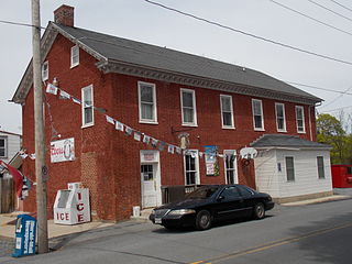
Leitersburg is a census-designated place (CDP) in Washington County, Maryland, United States. The population was 523 at the 2000 census.

<span class="mw-page-title-main">Ojo Amarillo, New Mexico</span> CDP in New Mexico, United States

Ojo Amarillo is a census-designated place (CDP) in San Juan County, New Mexico, United States. The population was 829 at the 2000 census. It is part of the Farmington Metropolitan Statistical Area.

Ingold is a census-designated place (CDP) in Sampson County, North Carolina, United States. The population was 484 at the 2000 census.

<span class="mw-page-title-main">Cape Meares, Oregon</span> Unincorporated community in the state of Oregon, United States

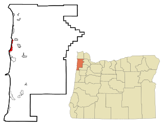
Cape Meares is a census-designated place (CDP) and unincorporated community in Tillamook County, Oregon, United States. The population was 110 at the 2000 census.

<span class="mw-page-title-main">Delano, Pennsylvania</span> CDP in Pennsylvania, United States

Delano is a census-designated place (CDP) in Schuylkill County, Pennsylvania, United States. The population was 377 at the 2000 census.

<span class="mw-page-title-main">North Eagle Butte, South Dakota</span> Census-designated place in South Dakota, United States

North Eagle Butte is a census-designated place (CDP) in Dewey County, South Dakota, United States, along the 45th parallel. The population was 1,879 at the 2020 census.

<span class="mw-page-title-main">Solis, Texas</span> Census-designated place in Texas, United States

Solis is a census-designated place (CDP) in Cameron County, Texas, United States. The population was 512 at the 2010 census. It is part of the Brownsville–Harlingen Metropolitan Statistical Area.

<span class="mw-page-title-main">Tradewinds, Texas</span> CDP in Texas, United States

Tradewinds is a census-designated place (CDP) in San Patricio County, Texas, United States. The population was 180 at the 2010 census.

Madison is a census-designated place (CDP) in the town of Madison in Somerset County, Maine, United States. The population was 2,533 at the 2020 census.

References

  1. "ArcGIS REST Services Directory". United States Census Bureau. Retrieved September 20, 2022.
  2. 1 2 U.S. Geological Survey Geographic Names Information System: Hightsville, North Carolina
  3. "Hightsville NC ZIP Code". zipdatamaps.com. 2023. Retrieved February 17, 2023.
  4. 1 2 "U.S. Census website". United States Census Bureau . Retrieved January 31, 2008.
  5. "Census of Population and Housing". Census.gov. Retrieved June 4, 2016.