Skippers Corner, North Carolina

Last updated

Skippers Corner, North Carolina
CDP
New Hanover County North Carolina incorporated and unincorporated areas Skippers Corner highlighted.svg
Location in New Hanover County and the state of North Carolina.
Coordinates: 34°19′45″N77°54′51″W / 34.32917°N 77.91417°W / 34.32917; -77.91417
Country United States
State North Carolina
County New Hanover
Area
[1]
  Total7.07 sq mi (18.32 km2)
  Land7.01 sq mi (18.15 km2)
  Water0.07 sq mi (0.17 km2)
Elevation
[2]
26 ft (8 m)
Population
 (2020)
  Total2,912
  Density415.64/sq mi (160.48/km2)
Time zone UTC-5 (Eastern (EST))
  Summer (DST) UTC-4 (EDT)
ZIP code
28429 [3]
Area codes 910, 472
FIPS code 37-62190 [4]
GNIS feature ID2402858 [2]

Skippers Corner is a census-designated place (CDP) in New Hanover County, North Carolina, United States. The population was 2,785 at the 2010 census, up from 1,246 in 2000. It is part of the Wilmington Metropolitan Statistical Area.

Contents

Geography

According to the United States Census Bureau, the CDP has a total area of 2.4 square miles (6.2 km2), all land.

Demographics

Historical population
CensusPop.Note
2020 2,912
U.S. Decennial Census [5]

As of the census [4] of 2000, there were 1,246 people, 427 households, and 351 families residing in the CDP. The population density was 512.5 people per square mile (197.9 people/km2). There were 449 housing units at an average density of 184.7 per square mile (71.3/km2). The racial makeup of the CDP was 88.52% White, 8.51% African American, 1.52% Native American, 0.80% from other races, and 0.64% from two or more races. Hispanic or Latino of any race were 4.82% of the population.

There were 427 households, out of which 41.0% had children under the age of 18 living with them, 70.5% were married couples living together, 8.2% had a female householder with no husband present, and 17.6% were non-families. 13.1% of all households were made up of individuals, and 4.2% had someone living alone who was 65 years of age or older. The average household size was 2.75 and the average family size was 3.01.

In the CDP, the population was spread out, with 23.4% under the age of 18, 9.6% from 18 to 24, 28.7% from 25 to 44, 28.3% from 45 to 64, and 10.0% who were 65 years of age or older. The median age was 39 years. For every 100 females, there were 100.3 males. For every 100 females age 18 and over, there were 96.7 males.

The median income for a household in the CDP was $40,938, and the median income for a family was $44,063. Males had a median income of $34,688 versus $21,722 for females. The per capita income for the CDP was $22,533. About 8.5% of families and 13.1% of the population were below the poverty line, including 13.6% of those under age 18 and 38.2% of those age 65 or over.

Related Research Articles

Kaibab is an unincorporated community and census-designated place (CDP) in Mohave County, Arizona, United States. It is within the Kaibab Indian Reservation. The population of the CDP was 140 at the 2020 census.

<span class="mw-page-title-main">Mesquite Creek, Arizona</span> CDP in Mohave County, Arizona

Mesquite Creek is an unincorporated community and census-designated place (CDP) in Mohave County, Arizona, United States. The population was 403 at the 2020 census.

<span class="mw-page-title-main">Spring Valley, Arizona</span> CDP in Yavapai County, Arizona

Spring Valley is a census-designated place (CDP) in Yavapai County, Arizona, United States. The population was 1,019 at the 2000 census.

<span class="mw-page-title-main">Fairview, California</span> CDP in California, United States

Fairview is a census-designated place (CDP) in Alameda County, California, United States. It borders on the city of Hayward and the census-designated place of Castro Valley. The population was 11,341 at the 2020 census.

Simsbury Center is a census-designated place (CDP) that consists of the central settlement, and the neighborhoods immediately surrounding it, in the town of Simsbury, Connecticut, in the United States. As of the 2010 census, the CDP had a population of 5,836. The core area of the CDP is listed as the Simsbury Center Historic District on the National Register of Historic Places.

<span class="mw-page-title-main">Ramblewood, New Jersey</span> Populated place in Burlington County, New Jersey, US

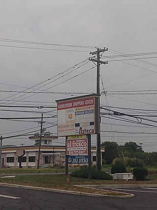
Ramblewood is an unincorporated community and census-designated place (CDP) located within Mount Laurel Township in Burlington County, in the U.S. state of New Jersey. As of the 2010 United States Census, the CDP's population was 5,907.

<span class="mw-page-title-main">Wynantskill, New York</span> CDP in New York, United States

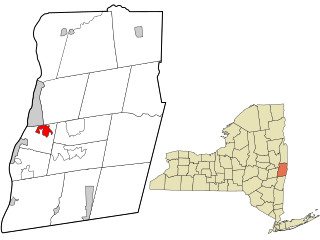
Wynantskill is a census-designated place (CDP) in Rensselaer County, New York, United States. The population was 3,276 at the 2010 census. Wynantskill is located at the northern town line and the northeastern corner of the town of North Greenbush. The community is a suburb of Troy. state route 66 is the main route through the community. Wynantskill has a major grocery store, several banks and restaurants, a craft beverage store, convenience stores, a post office, and a bowling alley, with almost all houses located on side streets off Main Ave. Other major roads are Whiteview Road, a primarily residential road that leads to US 4; and West Sand Lake Road.

<span class="mw-page-title-main">Scotts Corners, New York</span> CDP in New York, United States

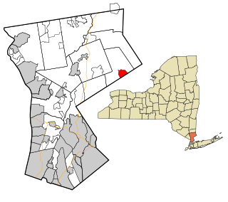
Scotts Corners is a hamlet located in the town of Pound Ridge in Westchester County, New York, United States. As of the 2010 census, the CDP population was 711, making Scotts Corners Westchester County's smallest census-recognized area.

Flat Rock is a census-designated place (CDP) in Surry County, North Carolina, United States. The name "Flat Rock" stems from the community's granite quarry. The granite quarry is the largest open-face granite quarry in the world, and has been mined continuously since 1889 by the North Carolina Granite Corporation.

<span class="mw-page-title-main">Maplewood Park, Ohio</span> Census-designated place in Ohio, United States

Maplewood Park is an unincorporated community and census-designated place in southern Hubbard Township, Trumbull County, Ohio, United States. The population was 243 at the 2020 census. It is part of the Youngstown–Warren metropolitan area.

<span class="mw-page-title-main">Pin Oak Acres, Oklahoma</span> CDP in Oklahoma, United States

Pin Oak Acres is a census-designated place (CDP) in Mayes County, Oklahoma, United States. The population was 427 at the 2000 census.

Sams Corner is a census-designated place (CDP) in Mayes County, Oklahoma, United States. The population was 137 at the 2010 census, compared to 126 at the 2000 census.

<span class="mw-page-title-main">Clarence, Pennsylvania</span> Census-designated place in Pennsylvania, United States

Clarence is a census-designated place (CDP) in Centre County, Pennsylvania, United States. It is part of the State College, Pennsylvania Metropolitan Statistical Area. The population was 626 at the 2010 census.

<span class="mw-page-title-main">Lucerne Mines, Pennsylvania</span> Census-designated place in Pennsylvania, United States

Lucernemines, usually written as Lucerne Mines, is a census-designated place (CDP) in Indiana County, Pennsylvania, United States. The population was 937 at the 2010 census.

<span class="mw-page-title-main">Gastonville, Pennsylvania</span> Census-designated place in Pennsylvania, United States

Gastonville is a census-designated place (CDP) in Washington County, Pennsylvania, United States. The population was 2,818 at the 2010 census.

<span class="mw-page-title-main">Bradley, West Virginia</span> Census-designated place in West Virginia, United States

Bradley is a census-designated place (CDP) in Raleigh County, West Virginia, United States, named in honor of General Omar Bradley, a field commander in North Africa and Europe during World War II and a General of the Army. The population was 2,040 at the 2010 census.

<span class="mw-page-title-main">Potter Lake, Wisconsin</span> CDP in Wisconsin, United States

Potter Lake is a census-designated place (CDP) in the town of East Troy, Walworth County, Wisconsin, United States. The population was 1,117 at the 2020 census.

<span class="mw-page-title-main">Westerly (CDP), Rhode Island</span> CDP in Rhode Island, United States

Westerly is a census-designated place (CDP) in the town of Westerly in Washington County, Rhode Island, United States. The population was 17,682 at the 2000 census.

<span class="mw-page-title-main">Glastonbury Center, Connecticut</span> Census-designated place in Connecticut, United States

Glastonbury Center is a census-designated place (CDP) that constitutes the densely populated center of the town of Glastonbury in Hartford County, Connecticut, United States. The population was 7,387 at the 2010 census, out of a total town population of 34,427.

<span class="mw-page-title-main">Clearbrook, New Jersey</span> Populated place in Middlesex County, New Jersey, US

Clearbrook is a gated community and census-designated place (CDP) located in Monroe Township, Middlesex County, in the U.S. state of New Jersey. It is in the western part of the township, bordered to the north by Encore at Monroe and to the east by Concordia and The Ponds. It is 3.5 miles (5.6 km) southwest of Jamesburg and 5 miles (8 km) northeast of Hightstown.

References

  1. "ArcGIS REST Services Directory". United States Census Bureau. Retrieved September 20, 2022.
  2. 1 2 U.S. Geological Survey Geographic Names Information System: Skippers Corner, North Carolina
  3. "Skippers Corner ZIP Code". zipdatamaps.com. 2023. Retrieved January 12, 2023.
  4. 1 2 "U.S. Census website". United States Census Bureau . Retrieved January 31, 2008.
  5. "Census of Population and Housing". Census.gov. Retrieved June 4, 2016.