Onslow Bay

Last updated
Map of Onslow Bay. Map of Onslow Bay North Carolina.jpg
Map of Onslow Bay.

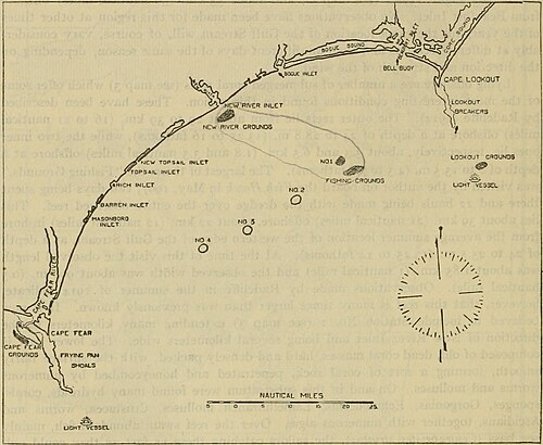
Onslow Bay is an indentation of the North Carolina coast, between Cape Fear in the south and Cape Lookout in the north. Thirteen barrier islands form the shore of the bay. It is part of the open Atlantic Ocean and affords no protection from oceanic swells.

Coordinates: 34°35′54″N77°12′01″W / 34.5984286°N 77.2002745°W / 34.5984286; -77.2002745


Related Research Articles

Gulf of St. Lawrence Outlet of the North American Great Lakes via the St. Lawrence River into the Atlantic Ocean

The Gulf of St. Lawrence is the outlet of the North American Great Lakes via the St. Lawrence River into the Atlantic Ocean. The gulf is a semi-enclosed sea, covering an area of about 226,000 square kilometres (87,000 sq mi) and containing about 34,500 cubic kilometres (8,300 cu mi) of water, which results in an average depth of 152 metres (499 ft).

Pender County, North Carolina County in North Carolina, United States

Pender County is a county located in the U.S. state of North Carolina. As of the 2010 census, the population was 52,217. Its county seat is Burgaw. Pender County is part of the Wilmington, NC Metropolitan Statistical Area.

Onslow County, North Carolina County in North Carolina, United States

Onslow County is a county located in the U.S. state of North Carolina. As of the 2010 census, the population was 177,772. Its county seat is Jacksonville. The county was created in 1734 as Onslow Precinct and gained county status in 1739. Onslow County comprises the Jacksonville, NC Metropolitan Statistical Area. The southern border is the coast of the Atlantic Ocean.

Jacksonville, North Carolina City in North Carolina, United States

Jacksonville is a city in Onslow County, North Carolina, United States. As of the 2010 United States census, the population was 70,145, which makes Jacksonville the 14th-largest city in North Carolina. Jacksonville is the county seat and most populous community of Onslow County, which is coterminous with the Jacksonville, North Carolina metropolitan area. In 2014, Forbes magazine ranked Jacksonville as the fifth-fastest growing small city in the United States. Demographically, Jacksonville is the youngest city in the United States, with an average age of 22.8 years old, which can be attributed to the large military presence. The low age may also be in part due to the population drastically going up over the past 80 years, from 783 in the 1930 census to 70,145 in the 2010 census.

Baffin Bay Marginal sea between Greenland and Baffin Island, Canada

Baffin Bay, located between Baffin Island and the west coast of Greenland, is defined by the International Hydrographic Organization as a marginal sea of the Arctic Ocean. It is sometimes considered a sea of North Atlantic Ocean. It is connected to the Atlantic via Davis Strait and the Labrador Sea. The narrower Nares Strait connects Baffin Bay with the Arctic Ocean. The bay is not navigable most of the year because of the ice cover and high density of floating ice and icebergs in the open areas. However, a polynya of about 80,000 km2 (31,000 sq mi), known as the North Water, opens in summer on the north near Smith Sound. Most of the aquatic life of the bay is concentrated near that region.

Labrador Sea Arm of the North Atlantic Ocean between the Labrador Peninsula and Greenland

The Labrador Sea is an arm of the North Atlantic Ocean between the Labrador Peninsula and Greenland. The sea is flanked by continental shelves to the southwest, northwest, and northeast. It connects to the north with Baffin Bay through the Davis Strait. It is a marginal sea of the Atlantic.

Cape Lookout (North Carolina)

Cape Lookout is the southern point of the Core Banks, one of the natural barrier islands on the Atlantic coast of North Carolina. It delimits Onslow Bay to the west from Raleigh Bay to the east. Core Banks and Shackleford Banks have been designated as parts of the Cape Lookout National Seashore.

The Fundy Shore Ecotour is a former scenic drive and network of tourist destinations in the Canadian province of Nova Scotia and encircles several sub-basins of the Bay of Fundy, which contains the highest tidal range on the planet.

Bogue Banks

Bogue Banks form a 21-mile (34 km) barrier island off the mainland of North Carolina in Carteret County. The island, separated from the mainland by Bogue Sound, runs east to west, with the ocean beaches facing due south. Bogue Banks is the only island on the Carteret County shore that has been developed with housing: numerous communities are located on the island and can be accessed by one of two bridges across Bogue Sound, either from Morehead City to Atlantic Beach, which is the more heavily traveled bridge, or from Cape Carteret to Emerald Isle. The communities of Bogue Banks are the most prominent of the Crystal Coast. NC 58 traverses a majority of the island's length. There are several hotels that dot the island, but most of the land contains private houses, some of which are rented out during the summer, or maritime forest. Stores and other commercial properties are limited to the five main communities.

Onslow Beach

Onslow Beach is a 12 kilometres (7.5 mi) stretch of undeveloped beach at Marine Corps Base Camp Lejeune in Onslow County, North Carolina, USA. It has been used at various times for practice amphibious landings by the U.S. Navy. Presently, it is used as a recreational area by the Camp Lejeune community.

Maple Hill is a sparse grouping of houses in Pender County, North Carolina, U.S.A. It also extends into Onslow County, North Carolina, U.S.A

Barden Inlet is the southernmost of the Outer Banks water inlets. Located just northwest of Cape Lookout in the U.S. state of North Carolina, the inlet connects Onslow Bay of the Atlantic Ocean with Core Sound. It separates the Shackleford Banks from the Core Banks.

Cape Fear (region)

Cape Fear is a coastal plain and Tidewater region of North Carolina centered about the city of Wilmington. The region takes its name from the adjacent Cape Fear headland, as does the Cape Fear River which flows through the region and empties into the Atlantic Ocean near the cape. Much of the region's populated areas are found along the Atlantic beaches and the Atlantic Intracoastal Waterway, while the rural areas are dominated by farms and swampland like that of the Green Swamp. The general area can be also identified by the titles "Lower Cape Fear", "Wilmington Metropolitan Area", "Southeastern North Carolina", and "Azalea Coast". The latter name is derived from the North Carolina Azalea Festival held annually in Wilmington. Municipalities in the area belong to the Cape Fear Council of Governments.

The Back Sound is a lagoon in eastern North Carolina. Running on an east–west axis, the sound separates Shackleford Banks to the south from the mainland and Harkers Island to the north. At the sound's eastern end lies Cape Lookout and Core Sound, while on the west end lies the Crystal Coast community of Beaufort and Bogue Sound. Barden Inlet at the eastern end, and Beaufort Inlet on the western end connect the sound to Onslow Bay. Much of the islands in the sound are protected as part of the Rachel Carson Estuarine Reserve, set aside for the protection of Banker horses.

Montclair is an unincorporated community in Onslow County, North Carolina. It lies at an elevation of 39 feet.

Military Ocean Terminal Sunny Point

Military Ocean Terminal Sunny Point (MOTSU) is one of the largest military terminals in the world. It serves as a transfer point between rail, trucks, and ships for the import and export of weapons, ammunition, explosives and military equipment for United States Army. The 596th Transportation Brigade, United States Army, operates the terminal.

Cape Fear Museum of History and Science Museum in Wilmington, North Carolina

Cape Fear Museum of History and Science is a museum located at 814 Market Street in downtown Wilmington in southeastern North Carolina. Founded in 1898, it is the oldest history museum in the state.

Borders of the oceans Limits of Earths oceanic waters

The borders of the oceans are the limits of Earth's oceanic waters. The definition and number of oceans can vary depending on the adopted criteria. The principal divisions of the five oceans are the Pacific Ocean, Atlantic Ocean, Indian Ocean, Southern (Antarctic) Ocean, and Arctic Ocean. Smaller regions of the oceans are called seas, gulfs, bays, straits, and other terms. Geologically, an ocean is an area of oceanic crust covered by water.