Cape Lookout (North Carolina)

Last updated
Cape Lookout appears left of center near the bottom of this view of North Carolina Coast. NCOuterBanks-EO.jpg
Cape Lookout appears left of center near the bottom of this view of North Carolina Coast.

Cape Lookout is the southern point of the Core Banks, one of the natural barrier islands on the Atlantic coast of North Carolina. It delimits Onslow Bay to the west from Raleigh Bay to the east. Core Banks and Shackleford Banks have been designated as parts of the Cape Lookout National Seashore. [1]

Contents

Part of Carteret County, the cape sits 11 miles (18 km) southeast of Beaufort. It is one of the state's three major capes, along with Cape Hatteras to the north and Cape Fear to the south.

The 163-foot (50 m) [2] Cape Lookout Lighthouse sits about three miles northeast of the cape's point. [3]

Climate

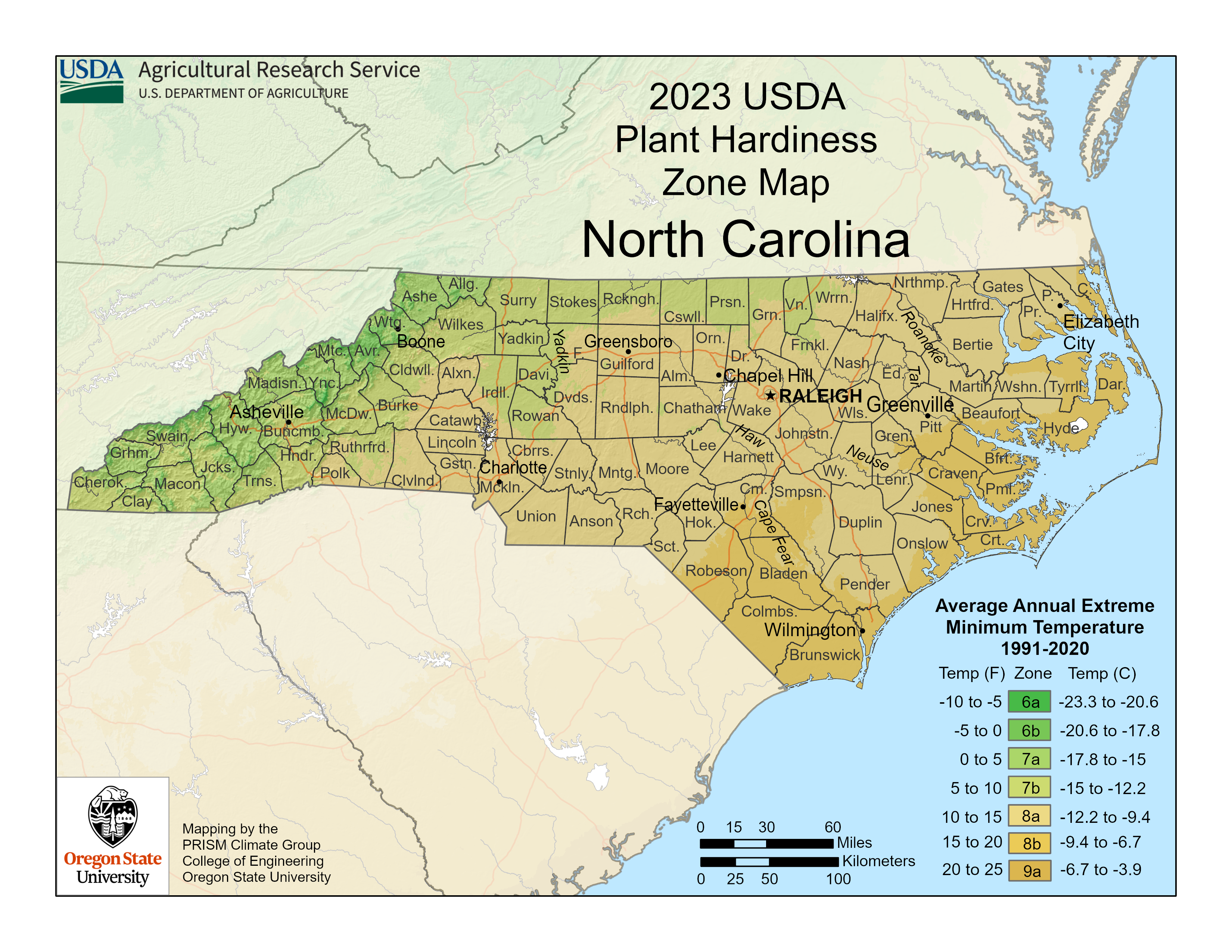
According to the Trewartha climate classification system, Cape Lookout, North Carolina has a humid subtropical climate with hot and humid summers, cool winters and year-around precipitation (Cfak). Cfak climates are characterized by all months having an average mean temperature > 32.0 °F (> 0.0 °C), at least eight months with an average mean temperature ≥ 50.0 °F (≥ 10.0 °C), at least one month with an average mean temperature ≥ 71.6 °F (≥ 22.0 °C) and no significant precipitation difference between seasons. During the summer months in Cape Lookout, a cooling afternoon sea breeze is present on most days, but episodes of extreme heat and humidity can occur with heat index values ≥ 100 °F (≥ 38 °C). Cape Lookout is prone to hurricane strikes, particularly during the Atlantic hurricane season which extends from June 1 through November 30, sharply peaking from late August through September. During the winter months, episodes of cold and wind can occur with wind chill values < 10 °F (< -12 °C). The plant hardiness zone in Cape Lookout is 8b with an average annual extreme minimum air temperature of 14.6 °F (-9.7 °C). [4] The average seasonal (Dec-Mar) snowfall total is < 2 inches (< 5 cm), and the average annual peak in nor'easter activity is in February.

Climate data for Cape Lookout, NC (1981-2010 Averages)
MonthJanFebMarAprMayJunJulAugSepOctNovDecYear
Mean daily maximum °F (°C)52.6
(11.4)
54.1
(12.3)
59.0
(15.0)
65.8
(18.8)
72.8
(22.7)
80.0
(26.7)
83.1
(28.4)
82.6
(28.1)
79.3
(26.3)
71.6
(22.0)
64.2
(17.9)
56.0
(13.3)
68.5
(20.3)
Daily mean °F (°C)46.4
(8.0)
48.0
(8.9)
53.2
(11.8)
60.6
(15.9)
68.1
(20.1)
76.0
(24.4)
79.5
(26.4)
78.8
(26.0)
75.0
(23.9)
66.1
(18.9)
57.9
(14.4)
49.7
(9.8)
63.3
(17.4)
Mean daily minimum °F (°C)40.1
(4.5)
41.8
(5.4)
47.3
(8.5)
55.4
(13.0)
63.4
(17.4)
71.9
(22.2)
75.9
(24.4)
75.0
(23.9)
70.8
(21.6)
60.5
(15.8)
51.6
(10.9)
43.4
(6.3)
58.2
(14.6)
Average precipitation inches (mm)4.52
(115)
3.71
(94)
4.42
(112)
3.31
(84)
4.27
(108)
4.52
(115)
6.02
(153)
7.26
(184)
6.71
(170)
4.48
(114)
4.05
(103)
4.01
(102)
57.28
(1,455)
Average relative humidity (%)74.775.174.574.976.779.082.279.778.975.177.575.977.0
Average dew point °F (°C)38.8
(3.8)
40.5
(4.7)
45.3
(7.4)
52.6
(11.4)
60.5
(15.8)
69.0
(20.6)
73.6
(23.1)
72.0
(22.2)
68.0
(20.0)
58.0
(14.4)
50.9
(10.5)
42.4
(5.8)
56.0
(13.3)
Source: PRISM [5]


Climate data for Cape Hatteras, NC Ocean Water Temperature (72 NE Cape Lookout)
MonthJanFebMarAprMayJunJulAugSepOctNovDecYear
Daily mean °F (°C)49
(9)
46
(8)
52
(11)
59
(15)
68
(20)
74
(23)
78
(26)
80
(27)
77
(25)
70
(21)
58
(14)
55
(13)
64
(18)
Source: NOAA [6]

Ecology

According to the A. W. Kuchler U.S. potential natural vegetation types, Cape Lookout, North Carolina would have a dominant vegetation type of Live oak/Sea Oats Uniola paniculata (90) with a dominant vegetation form of Coastal Prairie (20). [7]

Related Research Articles

<span class="mw-page-title-main">Kitty Hawk, North Carolina</span> Town in North Carolina, United States

Kitty Hawk is a town in Dare County, North Carolina, on Bodie Island, part of what is known as the state's Outer Banks. The population was 3,708 at the 2020 census. It was established in the early 18th century as Chickahawk.

<span class="mw-page-title-main">Kill Devil Hills, North Carolina</span> Town in North Carolina, United States

Kill Devil Hills is a town in Dare County, North Carolina, United States. The population was 7,633 at the 2020 census, up from 6,683 in 2010. It is the most populous settlement in both Dare County and on the Outer Banks of North Carolina. The Kill Devil Hills Micropolitan Statistical Area is part of the larger Virginia Beach-Norfolk, VA-NC Combined Statistical Area.

<span class="mw-page-title-main">Nags Head, North Carolina</span> Town in North Carolina, United States

Nags Head is a town in Dare County, North Carolina, United States. It is a busy vacation spot because of its beaches and sand dunes of Jockey's Ridge. The population was 3,146 at the 2020 census.

<span class="mw-page-title-main">Southern Shores, North Carolina</span> Town in North Carolina, United States

Southern Shores is a town in Dare County, North Carolina, United States. It is located on the Outer Banks and the population was 3,107 at the 2020 census.

<span class="mw-page-title-main">Cape Lookout National Seashore</span>

Cape Lookout National Seashore preserves a 56-mile (90-km) long section of the Southern Outer Banks, or Crystal Coast, of North Carolina, USA, running from Ocracoke Inlet on the northeast to Beaufort Inlet on the southwest. Three undeveloped barrier islands make up the seashore - North and South Core Banks and Shackleford Banks. The seashore includes two historic villages on Core Banks, Shackleford's wild horses, and the Cape Lookout Lighthouse, which has a black-and-white diamond pattern. A visitor center for the seashore is located on Harkers Island.

<span class="mw-page-title-main">Avon, North Carolina</span> Census-designated place in North Carolina, United States

Avon is an unincorporated community and census-designated place (CDP) in Dare County in the U.S. state of North Carolina. As of the 2010 census, it had a permanent population of 776.

<span class="mw-page-title-main">Rodanthe, North Carolina</span> Census-designated place in North Carolina, United States

Rodanthe is an unincorporated community and census-designated place (CDP) located in Dare County, North Carolina, United States, on Hatteras Island, part of North Carolina's Outer Banks. As of the 2020 census it had a population of 213. Rodanthe, along with Waves and Salvo, are part of the settlement of Chicamacomico. Rodanthe includes the original Chicamacomico Life-Saving Station, decommissioned in 1954, but now a museum.

<span class="mw-page-title-main">Waves, North Carolina</span> Census-designated place in North Carolina, United States

Waves is an unincorporated community and census-designated place (CDP) in Dare County, North Carolina, United States. It is on Hatteras Island, part of North Carolina's Outer Banks. As of the 2010 census it had a population of 134. Waves, along with Rodanthe and Salvo, are part of the settlement of Chicamacomico.

<span class="mw-page-title-main">Salvo, North Carolina</span> Census-designated place in North Carolina, United States

Salvo is a census-designated place located in Dare County, North Carolina, United States, on Hatteras Island, part of North Carolina's Outer Banks. As of the 2010 census, Salvo had a population of 229. Originally part of the settlement of Chicamacomico, Salvo was originally known as "Clarks" or "Clarksville."

<span class="mw-page-title-main">Portsmouth, North Carolina</span> United States historic place

Portsmouth was a fishing and shipping village located on Portsmouth Island on the Outer Banks in North Carolina, United States. Portsmouth Island is a tidal island connected, under most conditions, to the northern end of the North Core Banks, across Ocracoke Inlet from the village of Ocracoke. The town lies in Carteret County, was established in 1753 by the North Carolina Colonial Assembly, and abandoned in 1971. Its remains are now part of the Cape Lookout National Seashore.

<span class="mw-page-title-main">Buxton, North Carolina</span> Census-designated place in North Carolina, United States of America

Buxton is an unincorporated community and census-designated place (CDP) on Hatteras Island near Cape Hatteras. It is located in Dare County in the U.S. state of North Carolina. As of the 2010 census, it had a population of 1,273. Located at the widest part of Hatteras Island, it is the largest community on Hatteras Island both in terms of area and population, and is home to the island's schools and other major public buildings and offices.

<span class="mw-page-title-main">Frisco, North Carolina</span> Census-designated place in North Carolina, United States of America

Frisco is a small unincorporated community and census-designated place (CDP) on the barrier island of Hatteras Island, between the villages of Buxton and Hatteras. It is located in Dare County, North Carolina, United States, and was previously named "Trent", or "Trent Woods", but received a new name with the coming of the post office in 1898. Most of the land is taken by houses available for rental during the summer months, and as such the community's population varies seasonally. As of the 2010 census, the permanent population of the community was 200. North Carolina Highway 12 serves as the primary road in Frisco and connects the community to others on the island.

<span class="mw-page-title-main">Cape Hatteras National Seashore</span>

Cape Hatteras National Seashore is a United States national seashore which preserves the portion of the Outer Banks of North Carolina from Bodie Island to Ocracoke Island, stretching over 70 miles (110 km), and is managed by the National Park Service. Included within this section of barrier islands along N.C. 12, but outside the national seashore boundaries, are Pea Island National Wildlife Refuge and several communities, such as Rodanthe, Buxton, and Ocracoke. Cape Hatteras is a combination of natural and cultural resources, and provides a wide variety of recreational opportunities.

<span class="mw-page-title-main">Pea Island National Wildlife Refuge</span> National Wildlife Refuge in North Carolina, United States

Pea Island National Wildlife Refuge is a national wildlife refuge located on North Carolina's Pea Island, a coastal barrier island and part of a chain of islands known as the Outer Banks, adjacent to Cape Hatteras National Seashore. The sanctuary is located 10 miles (16 km) south of Nags Head, North Carolina on NC 12.

<span class="mw-page-title-main">Feasterville, Pennsylvania</span> Census-designated place in Pennsylvania, United States

Feasterville is a census-designated place located in Bucks County, Pennsylvania, United States. The community was part of Feasterville-Trevose, which was split into two separate CDPs, the other being Trevose. As of the 2010 census, the population was 3,074. Feasterville has grown by 2.02% since 2006.

<span class="mw-page-title-main">Neshaminy State Park</span> State park in the U.S. state of Pennsylvania

Neshaminy State Park is a 330-acre (134 ha) Pennsylvania state park in Bensalem Township, Bucks County, Pennsylvania in the United States. Visitors to the park can catch a glimpse of the Philadelphia skyline from a hiking trail on Logan Point. The park is located at the confluence of Neshaminy Creek and the Delaware River. Neshaminy State Park is just off Interstate 95 on Pennsylvania Route 132.

<span class="mw-page-title-main">Carova Beach, North Carolina</span> Unincorporated community in North Carolina, US

Carova Beach or Carova is an unincorporated community in Currituck County in the extreme northeastern corner of North Carolina, United States. The community, begun in the 1960s, is found on Currituck Banks, north of Bodie Island, and can be accessed only by boat or by four-wheel drive vehicle. There are no paved roads connecting Carova to the town of Corolla, North Carolina. The neighboring settlement of Sandbridge in Virginia Beach, Virginia, is not accessible by vehicle from Carova. In the 1960s, when development began in Carova, there were plans to construct a paved road from Sandbridge south to Carova through the Back Bay National Wildlife Refuge, but these never materialized. Today, there is a permanent fence from ocean to sound to keep vehicles from crossing and, more importantly, to keep the wild horses from migrating to the Virginia side of the border. To reach Carova, four-wheel drive vehicles must drive north along the beach from Corolla into the community, as access from Virginia is limited to pedestrians and bicyclists.

<span class="mw-page-title-main">Currituck National Wildlife Refuge</span> National Wildlife Refuge in North Carolina, United States

Currituck National Wildlife Refuge, located on the northern end of North Carolina's Outer Banks, was established in 1984 to preserve and protect the coastal barrier island ecosystem. Refuge lands are managed to provide wintering habitat for waterfowl and to protect endangered species such as piping plover, sea turtles, and seabeach amaranth.

<span class="mw-page-title-main">Cherry Valley National Wildlife Refuge</span>

The Cherry Valley National Wildlife Refuge is a National Wildlife Refuge in Monroe County, Pennsylvania.

<span class="mw-page-title-main">Core Banks, North Carolina</span> Barrier islands in North Carolina, US

The Core Banks are barrier islands in North Carolina, part of the Outer Banks and Cape Lookout National Seashore. Named after the Coree tribe, they extend from Ocracoke Inlet to Cape Lookout, and consist of two low-relief narrow islands, North Core Banks and South Core Banks, and, since September 2011, two smaller islands. New Drum Inlet, Old Drum Inlet and Ophelia Inlet now separate the islands. The Core Banks are now uninhabited. However, Portsmouth, at the north end of the North Core Banks, was once a substantial port, and Cape Lookout Village, about one and half miles south of the Cape Lookout Lighthouse, contains the historic Lookout Life-Saving Station, a U.S. Coast Guard Station, and several island homes.

References

  1. Cape Lookout National Seashore. "Current Documents" . Retrieved October 22, 2011.
  2. "CAPE LOOKOUT". www.outerbankslighthousesociety.org. Retrieved 2020-07-26.
  3. "Maps - Cape Lookout National Seashore (U.S. National Park Service)". www.nps.gov. Retrieved 2020-07-26.
  4. "USDA Interactive Plant Hardiness Map". United States Department of Agriculture. Archived from the original on July 4, 2019. Retrieved August 6, 2019.
  5. "PRISM Climate Group, Oregon State University" . Retrieved August 6, 2019.
  6. "Water Temperature Table of All Coastal Regions". Archived from the original on September 5, 2017. Retrieved August 6, 2019.
  7. "U.S. Potential Natural Vegetation, Original Kuchler Types, v2.0 (Spatially Adjusted to Correct Geometric Distortions)" . Retrieved August 6, 2019.
Preceded by Beaches of The Outer Banks Succeeded by

34°36′19″N76°32′10″W / 34.60528°N 76.53611°W / 34.60528; -76.53611