Oregon Inlet

Last updated

Oregon Inlet is an inlet along North Carolina's Outer Banks. It joins the Pamlico Sound with the Atlantic Ocean and separates Bodie Island from Pea Island, which are connected by the 2.8 mile Marc Basnight Bridge that spans the inlet. As one of the few access points to the ocean along this stretch of coast, Oregon Inlet is a major departure point for charter fishing trips, with a nearby harbor serving as the base for many large boats that travel miles out towards the Gulf Stream almost every day. The inlet is also the location of a U.S. Coast Guard motor lifeboat station.

Contents

History

Oregon Inlet was formed when a hurricane lashed the Outer Banks in 1846, separating Bodie Island from Pea Island. One ship that rode out that storm in Pamlico Sound was named the Oregon. After the storm the crew members of this ship were the first to tell those on the mainland about the inlet's formation. Hence, it has been known as Oregon Inlet ever since.

Like many other inlets along the Outer Banks, Oregon Inlet moves southward due to drifting sands during tides and storms. It has moved south over two miles since 1846, averaging around 66 feet per year. Shoaling of the channel through Oregon Inlet caused by this movement of sand has been a problem for the fishing industry, recreational boating, and other maritime interests for decades. Since 1950, when Congress first authorized the dredging of the inlet, [1] the channel has been shallower than planned most of the time and was sometimes closed altogether. In addition to the economic harm caused to the maritime community, several ships and lives have been lost. [2] In 2022, Dare County contracted for a dedicated dredge, Miss Katie , to focus on keeping Oregon Inlet navigable. [3]

Coast Guard station

Oregon Inlet Coast Guard Station, built for $3.5 million in 1990, as it looked in 2009. Coastguardoregoninlet.jpg
Oregon Inlet Coast Guard Station, built for $3.5 million in 1990, as it looked in 2009.

The Coast Guard station at Oregon Inlet is currently located at its fourth site since it began as a lifesaving station in 1883. It was one of 29 lifesaving stations Congress approved and appropriated funds for a decade earlier. By 1888, the Oregon Inlet Station had to be relocated to a new site. It is assumed that this relocation was necessary because of the shifting of the channel to the south and the encroachment of the ocean from the east. The station was decommissioned and moved to a new safer location some 400 feet westward toward the sound.

Less than a decade later a storm totally destroyed the Oregon Inlet Station. By 1897, a new station was under construction and was completed in 1898 for less than $7,000. As part of a modernization program in 1933-34, the Oregon Inlet Station was extensively modified to look very much like it does today. In 1979, a new extension was added. By 1988, the station was completely abandoned when the southward migration of the Oregon Inlet threatened to swallow it.

In July 1990, a ceremonial ground breaking was held for a new $3.5 million building, located just behind the Oregon Inlet Fishing Center, on the north side of the inlet. The new station was designed with the traditional architectural design of older stations located on the Outer Banks in mind.

Herbert C. Bonner Bridge

[ needs update ]

Herbert C. Bonner Bridge
Herbert C. Bonner Bridge, non-aerial.jpg
Oregon Inlet/Bonner Bridge
Coordinates 35°46′00.3″N75°31′39.8″W / 35.766750°N 75.527722°W / 35.766750; -75.527722
Locale Dare County
Other name(s)Oregon Inlet Bridge
Bonner Bridge
Named for Herbert C. Bonner
Owner NCDOT
Maintained by NCDOT
Characteristics
DesignSteel stringer
Total lengthBefore demolition 12,865.8 feet (3,921.5 m) After demolition 1,000 feet (300 m)
Width33.5 feet (10.2 m)
Clearance below 6.6 feet (2.0 m)
History
Opened1963
Closed2019
Location
Oregon Inlet

The Herbert C. Bonner Bridge was a two-lane automobile bridge spanning the Oregon Inlet, between Bodie Island from Pea Island, in Dare County, North Carolina. The bridge carried NC 12 and was utilized by local and seasonal tourist traffic. The 2.7-mile (4.3 km) bridge was built in 1963 and was dedicated to Herbert C. Bonner. [4]

The bridge shortly after completion in 1963 Herbert C. Bonner Bridge completion.jpg
The bridge shortly after completion in 1963

Prior to the building of the Bonner bridge, Hatteras Island was only accessible by air or ferry. Ferries could carry a maximum of 2,000 people per day. [5] The ferries cost the state $500,000 per year to operate, and there were very long lines waiting for the ferries during peak season. [5] Due to the constantly shifting sandbars in the inlet, groundings were a constant problem. The Bonner Bridge cost $4 million to build and moved up to 14,000 cars a day in both directions. [5] Of that amount, the state of North Carolina paid $1.5 million, and the federal government paid $2.5 million. [5] The arrangement for a portion of the state's cost to be paid by the National Park Service was arranged by Rep. Herbert C. Bonner, for whom the bridge is named. [5] The bridge also made it possible to provide electric power to the islands using transmission lines rather than generators. [6]

The environmental impact on the Bonner bridge and road was not fully understood at the time of construction, and now constant beach erosion, severe weather and high volume of traffic continually forces the state to protect the integrity of the road system. As much as $50 million was spent between 1987 and 1999 to repair and protect the Bonner Bridge and NC 12 from the ocean. The bridge was due for replacement by the early 1990s but construction on the new bridge had been continually held back by environmental lawsuits brought by the Southern Environmental Law Center. [7]

The Bonner Bridge was expected to have a thirty-year lifespan. [8] The bridge handled about 2 million cars per year, [9] and the state DOT ranked it a 4 on a scale of 1 to 100, with 100 being the safest. [4]

In October 1990, a dredge collided with the bridge during a storm, causing severe damage to several of the spans. [10] While isolated, Hatteras Island could only be accessed by boat or plane for many weeks while emergency construction was underway to replace its only highway link to the mainland. [11]

The Federal Highway Administration approved the plan to replace the bridge over Oregon Inlet that connects with Pea Island and lies within the Cape Hatteras National Seashore. [9] It would be longer and curve farther inland and was expected to cost approximately $1.3 billion and be completed by 2014, although it was likely to be later. [12] [13] On July 26, 2011 NCDOT awarded a $215.8 million contract to replace the bridge. In September 2013 the last of the legal obstacles were handled after a judge ruled in favor of the new bridge to be constructed. Construction was set to begin in early 2013 but was halted once again after an appeal was filed by the SELC. The new bridge was then to open to traffic in spring 2015 and the majority of the existing bridge was to be demolished (a portion will remain as a fishing pier).

On December 3, 2013, NCDOT closed the bridge due to immediate safety concerns. Routine sonar scanning of the bridge identified scouring concerns, or areas where too much sand has eroded from the support structure of the bridge. "Closing the Bonner Bridge is necessary to keep all travelers safe, but we know it will have a devastating effect on the people who live along and visit the Outer Banks," said NCDOT Secretary Tony Tata. "We will work to safely reopen this vital lifeline quickly, and hope to be able to begin construction on a new bridge as soon as possible." Until it was safe to reopen, The NCDOT Ferry Division provided emergency support to move cars and trucks across the Pamlico Sound between Rodanthe and Stumpy Point. [14] After sand was dredged to support some of its pilings, the bridge reopened to traffic on December 15, 2013.

On December 16, 2015, crews from Cape Hatteras Electric Cooperative began moving underground electric cables, which were subsequently attached to the old Bonner Bridge, that connected Hatteras Island to the cooperative's power supplier Dominion North Carolina Power. This was done in order for construction of the new bridge to begin and signaled the beginning of the bridge construction process. [15]

Marc Basnight Bridge

Marc Basnight Bridge
Coordinates 35°46′21″N75°32′14″W / 35.77250°N 75.53722°W / 35.77250; -75.53722
CarriesNC 12.svg NC 12
CrossesOregon Inlet
Locale Dare County
Named for Marc Basnight
Owner NCDOT
Maintained by NCDOT
Characteristics
Total length2.8 miles [16]
History
Designer HDR, Inc.
Engineering design by HDR, Inc.
Construction startMarch 8, 2016
Construction end2019
OpenedFebruary 25, 2019
Location
Oregon Inlet

The official groundbreaking for construction of the new bridge was held on March 8, 2016. [15] The project cost $252 million and the new bridge was expected to open in February 2019. [17]

A crew working on the bridge on July 27, 2017, severed a power cable and caused a widespread blackout on the Outer Banks islands. [18] 50,000 tourists had to be evacuated until power was restored August 3, 2017. [6]

The 2.8-mile-long bridge opened February 25, 2019. On March 7, 2019, state board of transportation voted to name the new bridge for Marc Basnight [19] despite the fact that during its three-year construction it had already become widely known as the New Bonner Bridge and had been repeatedly referred to as such in news articles. The decision to name the new bridge for Basnight was controversial and was opposed by many residents of Hatteras Island who wanted it to be named for Bonner. [20]

The bridge received the Deep Foundation Institute’s Outstanding Project Award in 2019 due to the bridge's innovative foundation, designed to withstand extreme bridge scour. [16]

Related Research Articles

<span class="mw-page-title-main">Dare County, North Carolina</span> County in North Carolina, United States

Dare County is the easternmost county in the U.S. state of North Carolina. As of the 2020 census, the population was 36,915. Its county seat is Manteo.

<span class="mw-page-title-main">Ocracoke, North Carolina</span> Census-designated place in North Carolina, United States

Ocracoke is a census-designated place (CDP) and unincorporated town located at the southern end of Ocracoke Island, located entirely within Hyde County, North Carolina, United States. The population was 948 as of the 2010 census. In the 2020 census, the population had dropped to 797 people.

<span class="mw-page-title-main">Pamlico Sound</span> Largest lagoon along the North American East Coast

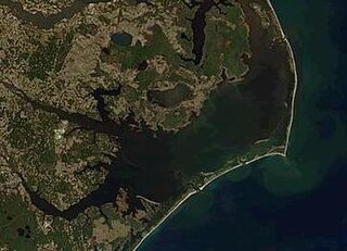
Pamlico Sound is a large estuarine lagoon in North Carolina. The largest lagoon along the North American East Coast, it extends 80 mi (130 km) long and 15 to 20 miles wide. It is part of a large, interconnected network of similar lagoons that includes Albemarle Sound, Currituck Sound, Croatan Sound, Roanoke Sound, Pamlico Sound, Bogue Sound, Back Sound, and Core Sound known collectively as the Albemarle-Pamlico sound system. With over 3,000 sq. mi. (7,800 km2) of open water the combined estuary is second only in size to 4,479 sq mi (11,600 km2) Chesapeake Bay in the United States.

<span class="mw-page-title-main">Cape Hatteras</span> Cape on the shoreline of Hatteras Island, North Carolina, United States

Cape Hatteras is a cape located at a pronounced bend in Hatteras Island, one of the barrier islands of North Carolina.

<span class="mw-page-title-main">Rodanthe, North Carolina</span> Census-designated place in North Carolina, United States

Rodanthe is an unincorporated community and census-designated place (CDP) located in Dare County, North Carolina, United States, on Hatteras Island, part of North Carolina's Outer Banks. As of the 2020 census it had a population of 213. Rodanthe, along with Waves and Salvo, are part of the settlement of Chicamacomico. Rodanthe includes the original Chicamacomico Life-Saving Station, decommissioned in 1954, but now a museum.

<span class="mw-page-title-main">Hatteras Island</span> Island in North Carolina, US

Hatteras Island is a barrier island located off the North Carolina coast. Dividing the Atlantic Ocean and the Pamlico Sound, it runs parallel to the coast, forming a bend at Cape Hatteras. It is part of North Carolina's Outer Banks and includes the communities of Rodanthe, Waves, Salvo, Avon, Buxton, Frisco, and Hatteras. It contains the largest part of the Cape Hatteras National Seashore. Prior to European settlement the island was inhabited by Croatoan Native Americans.

<span class="mw-page-title-main">Hatteras, North Carolina</span> Census-designated place in North Carolina, United States of America

Hatteras is an unincorporated village and census-designated place (CDP) in Dare County, North Carolina, United States, on the Outer Banks island of Hatteras, at its extreme southwestern tip. As of the 2010 census it had a population of 504. Immediately to the west of the village of Hatteras is Hatteras Inlet which separates Hatteras Island from the neighboring Ocracoke Island. North Carolina Highway 12 passes through the community linking it to Frisco to the east and Ocracoke to the west.

<span class="mw-page-title-main">Bodie Island Lighthouse</span> Lighthouse in North Carolina, United States

The current Bodie Island Lighthouse is the third that has stood in this vicinity of Bodie Island on the Outer Banks in North Carolina and was built in 1872. It stands 156 feet (48 m) tall and is located on the Roanoke Sound side of a portion of a peninsula that is the first part of the Cape Hatteras National Seashore. The lighthouse is just south of Nags Head, a few miles before Oregon Inlet. It was renovated from August 2009 to March 2013, and was made climbable by the public. There are 214 steps that spiral to the top. The 170-foot structure is one of only a dozen remaining tall, brick tower lighthouses in the United States — and one of the few with an original first-order Fresnel lens to cast its light.

<span class="mw-page-title-main">Herbert Covington Bonner</span> American politician

Herbert Covington Bonner was a Democratic U.S. Congressman from North Carolina between 1940 and 1965.

<span class="mw-page-title-main">Outer Banks</span> Barrier islands in North Carolina, United States

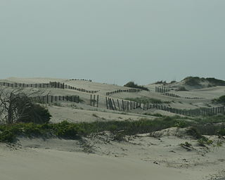
The Outer Banks are a 200 mi (320 km) string of barrier islands and spits off the coast of North Carolina and southeastern Virginia, on the east coast of the United States. They line most of the North Carolina coastline, separating Currituck Sound, Albemarle Sound, and Pamlico Sound from the Atlantic Ocean. A major tourist destination, the Outer Banks are known for their wide expanse of open beachfront and the Cape Hatteras National Seashore. The seashore and surrounding ecosystem are important biodiversity zones, including beach grasses and shrubland that help maintain the form of the land.

<span class="mw-page-title-main">North Carolina Highway 12</span> State highway in North Carolina, US

North Carolina Highway 12 (NC 12) is a 148.0-mile-long (238.2 km) primary state highway in the U.S. state of North Carolina, linking the peninsulas and islands of the northern Outer Banks. Most sections of NC 12 are two lanes wide, and there are also two North Carolina Ferry System routes which maintain continuity of the route as it traverses the Outer Banks region. NC 12 is part of the Outer Banks Scenic Byway, a National Scenic Byway. The first NC 12 appeared on the 1924 North Carolina Official Map and at its greatest length ran from NC 30 in Pollocksville to NC 48 near Murfreesboro. Over time it was replaced by both U.S. Route 258 (US 258) and NC 58 and ceased to exist in 1958. The current NC 12 first appeared on the 1964 state highway map running from US 158 in Nags Head to Ocracoke. In 1976 NC 12 was extended to US 70 on the mainland and in 1987 was extended north to Corolla.

New Inlet was an inlet along the Outer Banks of North Carolina joining Pamlico Sound with the Atlantic Ocean. It had not existed since 1945 before Hurricane Irene temporarily re-opened the inlet in 2011.

The North Carolina Department of Transportation Ferry Division is a branch of NCDOT that is responsible for the operation of over two dozen ferry services that transport passengers and vehicles to several islands along the Outer Banks of North Carolina.

<span class="mw-page-title-main">Effects of Hurricane Isabel in North Carolina</span>

The effects of Hurricane Isabel in North Carolina were widespread, with the heaviest damage in Dare County. The hurricane made landfall in the Outer Banks of North Carolina on September 18. There, storm surge flooding and strong winds damaged thousands of houses. The storm surge produced a 2,000 feet (610 m) wide inlet on Hatteras Island, isolating Hatteras by road for two months. Several locations along North Carolina Highway 12 were partially washed out or covered with debris. Hurricane Isabel produced hurricane-force wind gusts across eastern North Carolina, knocking down trees and power lines. About 700,000 residents lost power due to the storm, although most outages were restored within a few days. The hurricane killed three people in the state – two due to falling trees, and the other a utility worker attempting to restore electricity. Damage in the state totaled $450 million.

<span class="mw-page-title-main">Hatteras Inlet</span> Estuary in North Carolina, U.S.

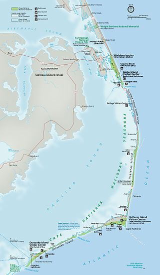
Hatteras Inlet is an estuary in North Carolina, located along the Outer Banks, separating Hatteras Island and Ocracoke Island. It connects the Atlantic Ocean to the Pamlico Sound. Hatteras Inlet is located entirely within Hyde County.

<span class="mw-page-title-main">Pea Island</span>

Pea Island is an island which is part of the Outer Banks of North Carolina. Because of the shifting nature of the barrier island system of which Pea Island is a part, and the way in which inlets open and close over time, Pea Island has, at times, been contiguous with the neighboring islands of Bodie Island or Hatteras Island. Pea Island was created when two inlets, the New Inlet in 1738, and Oregon Inlet in 1846, separated it from the neighboring islands. The island was rejoined to Hatteras Island intermittently from 1922 until 1945 as the narrow New Inlet opened and closed with shifting sands. From 1945 to 2011, Pea Island was merely the northern 11 miles or so of Hatteras Island. Hurricane Irene reopened the New Inlet, making Pea Island separate again, although it has since reconnected with Hatteras. Pea Island was home to the Pea Island Life-Saving Station, the first U.S. Coast Guard life-saving station to have an all African-American crew. Since 1937, it has also been home to the Pea Island National Wildlife Refuge.

Bodie Island is a long, narrow barrier peninsula that forms the northernmost portion of the Outer Banks. The land that is most commonly referred to as Bodie Island was at one time a true island, but in 1811 Roanoke Inlet, which had separated it from the Currituck Banks in the north, closed. As a result, the Currituck Banks and Bodie Island are now one contiguous peninsula, joined at the Nags Head area, where the inlet once flowed. Today, either name can be used to refer to the peninsula as a whole, but both portions colloquially retain their historical names.

<span class="mw-page-title-main">Cape Hatteras Electric Cooperative</span>

Cape Hatteras Electric Cooperative (CHEC) is a utility cooperative that distributes electricity to Hatteras and Ocracoke islands in the Outer Banks region of the state of North Carolina. The electric cooperative was founded in 1945 and is headquartered in Buxton.

<span class="mw-page-title-main">Rodanthe Bridge</span> Bridge in North Carolina, United States

The Rodanthe Bridge, commonly called the Jug Handle Bridge, is a 2.4-mile-long (3.9 km) two-lane "jug handle" trestle bridge in Dare County, North Carolina. The bridge carries North Carolina Highway 12 from Rodanthe to the southern point of Pea Island National Wildlife Refuge by going west into the Pamlico Sound and then parallel an area of the Hatteras Island that is prone to coastal erosion, washouts, and flooding from storms.

<i>Miss Katie</i> (2022 ship) Hopper dredge

Miss Katie is a hopper dredge owned by EJE Dredging Service, LLC. Her primary mission is to maintain the channels through Oregon Inlet and nearby Hatteras Inlet in the Outer Banks of North Carolina. Keeping these navigable waterways open is important to local fishing, recreational boating, and other maritime interests.

References

  1. River and Harbor Act of 1950; Public Law 81-516 (PDF). Washington, D.C.: United States Congress. 1950. p. 163.
  2. Oregon Inlet Jetty Project (PDF). Washington, D.C.: General Accounting Office. 2002.
  3. "Public-Private Partnership Dredge Miss Katie Christened". The Waterways Journal. November 4, 2022. Retrieved March 1, 2023.
  4. 1 2 James, Erin (July 7, 2011). "NCDOT: Suit Won't Delay Bonner Bridge Replacement". The Virginian-Pilot.
  5. 1 2 3 4 5 Shires, William A. (November 16, 1963). "New Oregon Inlet Bridge Will Enable Many To Visit Hatteras". The Dispatch. Lexington, North Carolina. p. 4.
  6. 1 2 Hampton, Jeff; Hafner, Katherine (August 3, 2017). "With power restored to Hatteras, Ocracoke islands, tourists can return at noon Friday". The Virginian-Pilot. Retrieved August 31, 2017.
  7. "Archived copy" (PDF). Archived from the original (PDF) on October 31, 2007. Retrieved August 28, 2007.{{cite web}}: CS1 maint: archived copy as title (link)
  8. "DOT: Replace the Bonner Bridge". The Times-News. Associated Press. April 24, 1991 via Google News Archive.
  9. 1 2 Breen, Tom (December 21, 2010). "Bonner Bridge Replacement Gets Green Light in NC". Bloomberg Businessweek. Associated Press. Archived from the original on September 23, 2015.
  10. "Bridge Collapse Isolates Hatteras Island". The Pittsburgh Press. Associated Press. October 27, 1990. p. A2.
  11. "The Bonner Bridge at Oregon Inlet, damaged by a dredge: The Outer Banks of North Carolina - Dare County, Currituck County, and Hyde County [NC]". Outerbanks.com. Retrieved July 16, 2009.
  12. "Agencies Agree On First Stage in Replacing Bonner Bridge". WRAL.com<!. August 27, 2007. Retrieved July 16, 2009.
  13. "NCDOT: Bonner Bridge" . Retrieved March 26, 2010.
  14. "NCDOT STATEMENT on Bonner Bridge Closing". WVEC.com. December 3, 2013. Retrieved December 3, 2013.
  15. 1 2 Bonner Bridge Replace ncdot.gov [ dead link ]
  16. 1 2 "North Carolina's Basnight Bridge Recognized for Innovative Use of Concrete Piles". ForConstructionPros.com. June 20, 2019. Retrieved June 24, 2019.
  17. Waggoner, Martha (February 9, 2019). "Bonner Bridge replacement finally opening at Outer Banks". Raleigh, NC: WNCN-TV. Retrieved February 10, 2019.
  18. Dobrin, Isabel; Sidersky, Robyn (July 27, 2017). "More than 7,000 on Hatteras and Ocracoke are without power, and a fix was expected to take days or weeks". The Virginian-Pilot . Retrieved July 29, 2017.
  19. "Transportation Board Votes to Name New Oregon Inlet Bridge in Honor of Marc Basnight". NC Dept. of Transportation Press Releases. March 7, 2019. Retrieved June 21, 2019.
  20. "Bridge naming is controversial". February 27, 2019.