Cape Lookout National Seashore

Last updated
Cape Lookout National Seashore
IUCN category V (protected landscape/seascape)
Cape Lookout Lighthouse - 2013-06 - 07.JPG
Cape Lookout Lighthouse
USA North Carolina relief location map.jpg
Red pog.svg
Usa edcp relief location map.png
Red pog.svg
Location Outer Banks, Carteret County, North Carolina, United States
Nearest city Harkers Island, NC
Coordinates 34°36′19″N76°32′11″W / 34.60528°N 76.53639°W / 34.60528; -76.53639
Area28,243 acres (114.30 km2) [1]
EstablishedMarch 10, 1966
Visitors541,533(in 2022) [2]
Governing body National Park Service
Website Cape Lookout National Seashore

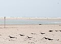
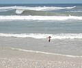
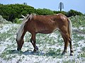
Cape Lookout National Seashore preserves a 56-mile (90-km) long section of the Southern Outer Banks, or Crystal Coast, of North Carolina, USA, running from Ocracoke Inlet on the northeast to Beaufort Inlet on the southwest. Three undeveloped barrier islands make up the seashore - North and South Core Banks and Shackleford Banks. The seashore includes two historic villages on Core Banks, Shackleford's wild horses, and the Cape Lookout Lighthouse, which has a black-and-white diamond pattern. A visitor center for the seashore is located on Harkers Island.

Contents

The National Park Service, as part of their Centennial Initiative celebrating its 100th anniversary in 2016, is planning to rehabilitate the Lighthouse and restore the Cape Lookout and Portsmouth Village Historic Districts. [3]

History

The National Seashore was authorized on March 10, 1966. It was named a North Carolina Natural Heritage Area on May 23, 1986. The seashore was designated the Carolinian-South Atlantic Biosphere Reserve on June 16, 1986. Near noon on September 9, 2007, Tropical Storm Gabrielle made landfall at this exact point with winds of 60 mph (97 km/h). Damage was light but flooding and beach erosion affected this lookout. On August 27, 2011, Hurricane Irene made landfall near Cape Lookout as a Category 1 storm with 85 mph sustained winds. Hurricane Arthur also made landfall near Cape Lookout as a Category 2 storm with 100 mph sustained winds.

Laws

The Corolla Wild Horses Protection Act (H.R. 126;113th Congress), if passed, would take wild horses from herds on the Cape Lookout National Seashore and introduced them to the herds in the Currituck National Wildlife Refuge in order to ensure genetic viability. [4]

Map

Official National Park Service map Cape Lookout National Seashore - NPS map.pdf
Official National Park Service map

Climate

According to the Trewartha climate classification system, Cape Lookout National Seashore, North Carolina has a humid subtropical climate with hot and humid summers, cool winters and year-around precipitation (Cfak). Cfak climates are characterized by all months having an average mean temperature > 32.0 °F (> 0.0 °C), at least eight months with an average mean temperature ≥ 50.0 °F (≥ 10.0 °C), at least one month with an average mean temperature ≥ 71.6 °F (≥ 22.0 °C) and no significant precipitation difference between seasons. During the summer months in Cape Lookout National Seashore, a cooling afternoon sea breeze is present on most days, but episodes of extreme heat and humidity can occur with heat index values ≥ 100 °F (≥ 38 °C). Cape Lookout National Seashore is prone to hurricane strikes, particularly during the Atlantic hurricane season which extends from June 1 through November 30, sharply peaking from late August through September. During the winter months, episodes of cold and wind can occur with wind chill values < 10 °F (< -12 °C). The plant hardiness zone at Core Sound in Cape Lookout National Seashore is 8b with an average annual extreme minimum air temperature of 16.6 °F (-8.6 °C). [5] The average seasonal (Dec-Mar) snowfall total is < 2 inches (< 5 cm), and the average annual peak in nor'easter activity is in February.

Climate data for Core Sound, Cape Lookout National Seashore, NC (1981-2010 Averages)
MonthJanFebMarAprMayJunJulAugSepOctNovDecYear
Average high °F (°C)52.9
(11.6)
54.8
(12.7)
60.4
(15.8)
67.7
(19.8)
74.8
(23.8)
81.6
(27.6)
84.7
(29.3)
84.0
(28.9)
80.4
(26.9)
72.6
(22.6)
64.9
(18.3)
56.4
(13.6)
69.7
(20.9)
Daily mean °F (°C)45.4
(7.4)
47.4
(8.6)
53.0
(11.7)
60.6
(15.9)
68.2
(20.1)
75.8
(24.3)
79.3
(26.3)
78.4
(25.8)
74.5
(23.6)
65.5
(18.6)
57.3
(14.1)
48.9
(9.4)
62.9
(17.2)
Average low °F (°C)37.9
(3.3)
39.9
(4.4)
45.5
(7.5)
53.5
(11.9)
61.6
(16.4)
70.0
(21.1)
73.8
(23.2)
72.8
(22.7)
68.5
(20.3)
58.4
(14.7)
49.7
(9.8)
41.3
(5.2)
56.1
(13.4)
Average precipitation inches (mm)4.62
(117)
3.60
(91)
4.51
(115)
3.42
(87)
4.00
(102)
4.20
(107)
5.93
(151)
7.30
(185)
6.35
(161)
4.62
(117)
4.04
(103)
4.06
(103)
56.65
(1,439)
Average relative humidity (%)71.771.669.570.973.277.179.278.677.074.074.673.274.2
Average dew point °F (°C)36.8
(2.7)
38.7
(3.7)
43.3
(6.3)
51.1
(10.6)
59.3
(15.2)
68.1
(20.1)
72.3
(22.4)
71.2
(21.8)
66.8
(19.3)
57.0
(13.9)
49.3
(9.6)
40.7
(4.8)
54.6
(12.6)
Source: PRISM [6]


Climate data for Cape Hatteras, NC Ocean Water Temperature (53 NE Core Sound)
MonthJanFebMarAprMayJunJulAugSepOctNovDecYear
Daily mean °F (°C)49
(9)
46
(8)
52
(11)
59
(15)
68
(20)
74
(23)
78
(26)
80
(27)
77
(25)
70
(21)
58
(14)
55
(13)
64
(18)
Source: NOAA [7]

Ecology

According to the A. W. Kuchler U.S. potential natural vegetation types, Cape Lookout National Seashore, North Carolina would have a dominant vegetation type of Live oak/Sea Oats Uniola paniculata (90) with a dominant vegetation form of Coastal Prairie (20). [8]

Wildlife

Bibliography

Notes

  1. "Listing of acreage – December 31, 2011" (XLSX). Land Resource Division, National Park Service. Retrieved 2012-12-26. (National Park Service Acreage Reports)
  2. "NPS Annual Recreation Visits Report". National Park Service. Retrieved October 16, 2023.
  3. Bomar, Mary A. (August 2007). "Summary of Park Centennial Strategies" (PDF). National Park Service. Retrieved 2008-02-15.
  4. "H.R. 126 - Summary". United States Congress. Retrieved 5 June 2013.
  5. "USDA Interactive Plant Hardiness Map". United States Department of Agriculture. Archived from the original on July 4, 2019. Retrieved August 6, 2019.
  6. "PRISM Climate Group, Oregon State University" . Retrieved August 6, 2019.
  7. "Water Temperature Table of All Coastal Regions". Archived from the original on September 5, 2017. Retrieved August 6, 2019.
  8. "U.S. Potential Natural Vegetation, Original Kuchler Types, v2.0 (Spatially Adjusted to Correct Geometric Distortions)" . Retrieved August 6, 2019.

Related Research Articles

<span class="mw-page-title-main">Kitty Hawk, North Carolina</span> Town in North Carolina, United States

Kitty Hawk is a town in Dare County, North Carolina, on Bodie Island, part of what is known as the state's Outer Banks. The population was 3,708 at the 2020 census. It was established in the early 18th century as Chickahawk.

<span class="mw-page-title-main">Kill Devil Hills, North Carolina</span> Town in North Carolina, United States

Kill Devil Hills is a town in Dare County, North Carolina, United States. The population was 7,633 at the 2020 census, up from 6,683 in 2010. It is the most populous settlement in both Dare County and on the Outer Banks of North Carolina. The Kill Devil Hills Micropolitan Statistical Area is part of the larger Virginia Beach-Norfolk, VA-NC Combined Statistical Area.

<span class="mw-page-title-main">Nags Head, North Carolina</span> Town in North Carolina, United States

Nags Head is a town in Dare County, North Carolina, United States. It is a busy vacation spot because of its beaches and sand dunes of Jockey's Ridge. The population was 3,146 at the 2020 census.

<span class="mw-page-title-main">Southern Shores, North Carolina</span> Town in North Carolina, United States

Southern Shores is a town in Dare County, North Carolina, United States. It is located on the Outer Banks and the population was 3,107 at the 2020 census.

<span class="mw-page-title-main">Cape Hatteras</span> Cape on the shoreline of Hatteras Island, North Carolina, United States

Cape Hatteras is a cape located at a pronounced bend in Hatteras Island, one of the barrier islands of North Carolina.

<span class="mw-page-title-main">Avon, North Carolina</span> Census-designated place in North Carolina, United States

Avon is an unincorporated community and census-designated place (CDP) in Dare County in the U.S. state of North Carolina. As of the 2010 census, it had a permanent population of 776.

<span class="mw-page-title-main">Rodanthe, North Carolina</span> Census-designated place in North Carolina, United States

Rodanthe is an unincorporated community and census-designated place (CDP) located in Dare County, North Carolina, United States, on Hatteras Island, part of North Carolina's Outer Banks. As of the 2020 census it had a population of 213. Rodanthe, along with Waves and Salvo, are part of the settlement of Chicamacomico. Rodanthe includes the original Chicamacomico Life-Saving Station, decommissioned in 1954, but now a museum.

<span class="mw-page-title-main">Waves, North Carolina</span> Census-designated place in North Carolina, United States

Waves is an unincorporated community and census-designated place (CDP) in Dare County, North Carolina, United States. It is on Hatteras Island, part of North Carolina's Outer Banks. As of the 2010 census it had a population of 134. Waves, along with Rodanthe and Salvo, are part of the settlement of Chicamacomico.

<span class="mw-page-title-main">Salvo, North Carolina</span> Census-designated place in North Carolina, United States

Salvo is a census-designated place located in Dare County, North Carolina, United States, on Hatteras Island, part of North Carolina's Outer Banks. As of the 2010 census, Salvo had a population of 229. Originally part of the settlement of Chicamacomico, Salvo was originally known as "Clarks" or "Clarksville."

<span class="mw-page-title-main">Portsmouth, North Carolina</span> United States historic place

Portsmouth was a fishing and shipping village located on Portsmouth Island on the Outer Banks in North Carolina, United States. Portsmouth Island is a tidal island connected, under most conditions, to the northern end of the North Core Banks, across Ocracoke Inlet from the village of Ocracoke. The town lies in Carteret County, was established in 1753 by the North Carolina Colonial Assembly, and abandoned in 1971. Its remains are now part of the Cape Lookout National Seashore.

<span class="mw-page-title-main">Buxton, North Carolina</span> Census-designated place in North Carolina, United States of America

Buxton is an unincorporated community and census-designated place (CDP) on Hatteras Island near Cape Hatteras. It is located in Dare County in the U.S. state of North Carolina. As of the 2010 census, it had a population of 1,273. Located at the widest part of Hatteras Island, it is the largest community on Hatteras Island both in terms of area and population, and is home to the island's schools and other major public buildings and offices.

<span class="mw-page-title-main">Frisco, North Carolina</span> Census-designated place in North Carolina, United States of America

Frisco is a small unincorporated community and census-designated place (CDP) on the barrier island of Hatteras Island, between the villages of Buxton and Hatteras. It is located in Dare County, North Carolina, United States, and was previously named "Trent", or "Trent Woods", but received a new name with the coming of the post office in 1898. Most of the land is taken by houses available for rental during the summer months, and as such the community's population varies seasonally. As of the 2010 census, the permanent population of the community was 200. North Carolina Highway 12 serves as the primary road in Frisco and connects the community to others on the island.

<span class="mw-page-title-main">Cape Hatteras National Seashore</span>

Cape Hatteras National Seashore is a United States national seashore which preserves the portion of the Outer Banks of North Carolina from Bodie Island to Ocracoke Island, stretching over 70 miles (110 km), and is managed by the National Park Service. Included within this section of barrier islands along N.C. 12, but outside the national seashore boundaries, are Pea Island National Wildlife Refuge and several communities, such as Rodanthe, Buxton, and Ocracoke. Cape Hatteras is a combination of natural and cultural resources, and provides a wide variety of recreational opportunities.

<span class="mw-page-title-main">Cape Lookout (North Carolina)</span>

Cape Lookout is the southern point of the Core Banks, one of the natural barrier islands on the Atlantic coast of North Carolina. It delimits Onslow Bay to the west from Raleigh Bay to the east. Core Banks and Shackleford Banks have been designated as parts of the Cape Lookout National Seashore.

<span class="mw-page-title-main">Outer Banks</span> Barrier islands in North Carolina, U.S.

The Outer Banks are a 200 mi (320 km) string of barrier islands and spits off the coast of North Carolina and southeastern Virginia, on the east coast of the United States. They line most of the North Carolina coastline, separating Currituck Sound, Albemarle Sound, and Pamlico Sound from the Atlantic Ocean. A major tourist destination, the Outer Banks are known for their wide expanse of open beachfront and the Cape Hatteras National Seashore. The seashore and surrounding ecosystem are important biodiversity zones, including beach grasses and shrubland that help maintain the form of the land.

Shackleford Banks is a barrier island system on the coast of Carteret County, North Carolina. It contains a herd of feral horses, scallop, crabs and various sea animals, including summer nesting by loggerhead turtles. It is a tourist and beach camping site.

<span class="mw-page-title-main">Pea Island National Wildlife Refuge</span> National Wildlife Refuge in North Carolina, United States

Pea Island National Wildlife Refuge is a national wildlife refuge located on North Carolina's Pea Island, a coastal barrier island and part of a chain of islands known as the Outer Banks, adjacent to Cape Hatteras National Seashore. The sanctuary is located 10 miles (16 km) south of Nags Head, North Carolina on NC 12.

<span class="mw-page-title-main">Carova Beach, North Carolina</span>

Carova Beach or Carova is an unincorporated community in Currituck County in the extreme northeastern corner of North Carolina, United States. The community, begun in the 1960s, is found on Currituck Banks, north of Bodie Island, and can be accessed only by boat or by four-wheel drive vehicle. There are no paved roads connecting Carova to the town of Corolla, North Carolina. The neighboring settlement of Sandbridge in Virginia Beach, Virginia is not accessible by vehicle from Carova. In the 1960s, when development began in Carova, there were plans to construct a paved road from Sandbridge south to Carova through the Back Bay National Wildlife Refuge, but these never materialized. Today, there is a permanent fence from ocean to sound to keep vehicles from crossing and, more importantly, to keep the wild horses from migrating to the Virginia side of the border. To reach Carova, four-wheel drive vehicles must drive north along the beach from Corolla into the community, as access from Virginia is limited to pedestrians and bicyclists.

<span class="mw-page-title-main">Currituck National Wildlife Refuge</span> National Wildlife Refuge in North Carolina, United States

Currituck National Wildlife Refuge, located on the northern end of North Carolina's Outer Banks, was established in 1984 to preserve and protect the coastal barrier island ecosystem. Refuge lands are managed to provide wintering habitat for waterfowl and to protect endangered species such as piping plover, sea turtles, and seabeach amaranth.

<span class="mw-page-title-main">Core Banks, North Carolina</span> Barrier islands in North Carolina, US

The Core Banks are barrier islands in North Carolina, part of the Outer Banks and Cape Lookout National Seashore. Named after the Coree tribe, they extend from Ocracoke Inlet to Cape Lookout, and consist of two low-relief narrow islands, North Core Banks and South Core Banks, and, since September 2011, two smaller islands. New Drum Inlet, Old Drum Inlet and Ophelia Inlet now separate the islands. The Core Banks are now uninhabited. However, Portsmouth, at the north end of the North Core Banks, was once a substantial port, and Cape Lookout Village, about one and half miles south of the Cape Lookout Lighthouse, contains the historic Lookout Life-Saving Station, a U.S. Coast Guard Station, and several island homes.