| Name | Image | States on route | Agency | Year est. [15] | Length [15] | Description |
|---|
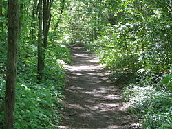
| Ala Kahakai |  | Hawaii | NPS | 2000 | 175 mi (280 km) | Trail segments on the west and south shores of Hawaiʻi island protect the ancient ala loa (long trail) used by Native Hawaiians for generations. This natural and cultural landscape crosses lava flows of Hawaiʻi Volcanoes National Park and sandy beaches with anchialine pools. Archaeological sites include Kaloko-Honokōhau (wetlands and fishponds) and Puʻuhonua o Hōnaunau National Historical Parks (place of refuge) and Puʻukoholā Heiau National Historic Site (Kamehameha I's temple). [31] |
|---|
| Butterfield Overland |  | Missouri, Tennessee, Arkansas, Oklahoma, Texas, New Mexico, Arizona, California | NPS | 2023 | 3,292 mi (5,300 km) | The Butterfield Overland Mail Company operated a stagecoach route between 1858 and 1861 to transport mail and passengers along a southern route between St. Louis and Memphis and San Francisco. Founded by John Butterfield, the route had nine divisions traversed by higher-speed wagons until the Civil War broke out. [32] |
|---|
| California |  | Missouri, Kansas, Nebraska, Colorado, Wyoming, Idaho, Utah, Nevada, California, Oregon | NPS | 1992 | 5,600 mi (9,010 km) | The 1841 Bartleson–Bidwell Party, 1844 Stephens–Townsend–Murphy Party, and 1846 Donner Party (Donner Pass pictured) were among the few early overland emigrants to northern California, but the discovery of gold at Sutter's Mill in 1848 sparked the massive California Gold Rush. Some 140,000 "Forty-Niners" made the trip over the next five years via the overland emigrant trail starting in Missouri, going along the Platte River, around the Great Salt Lake, and over the Sierra Nevada (the same number came by sea). Several branching cutoffs and routes to the mines and supporting cities developed, the most popular being the Carson Trail to Sutter's Fort, Sacramento. While the population explosion led to California's statehood, it also resulted in the genocide of the state's Native Americans. [33] |
|---|
| Captain John Smith Chesapeake | 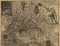 | Virginia, Maryland, Delaware, District of Columbia | NPS | 2006 | 3,000 mi (4,830 km) | This is a water trail based on the routes John Smith, a founder of the Jamestown settlement, took to survey Chesapeake Bay in 1607–1609. On Smith's explorations he mapped (pictured) the Bay's tributaries and communities of Native Americans he met. The trail today includes a network of historical and natural partner sites, including maritime museums, wildlife refuges, state and local parks, and interpretive buoys, in addition to water trails for canoeing and kayaking. [34] |
|---|
| Chilkoot |  | Alaska | NPS | 2022 | 16.5 mi (30 km) | Originally used as a trade route between the coast and the interior by Tlingit people, the Chilkoot Trail was a main access route to the Yukon during the Klondike Gold Rush. Between 1896 and 1899 around 22,000 prospectors made their way from Dyea, Alaska to Bennett Lake, British Columbia, carrying one ton of gear across Chilkoot Pass. It is part of the Skagway unit of Klondike Gold Rush National Historical Park, and continues as Chilkoot Trail National Historic Site in B.C. Together, they form parts of Klondike Gold Rush International Historical Park. Thousands of visitors now hike on the route each year, from the coastal rainforest to high alpine mountains. [35] |
|---|
| El Camino Real de los Tejas |  | Texas, Louisiana | NPS | 2004 | 2,600 mi (4,180 km) | The Royal Road of the Tejas is the group of roads through Spanish Texas established by its first governors in the 1680s and 1690s. The Spanish initially attempted trade and proselytization at Mission Tejas in Eastern Texas and Los Adaes, Louisiana, before moving the capital to San Antonio and building a series of missions (Mission Espada pictured) in the early 18th century. Mexican and American ranchers settled along the corridor toward the Rio Grande, including the Old San Antonio Road, through Texas independence and annexation in 1845. [36] |
|---|
| El Camino Real de Tierra Adentro | 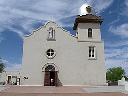 | New Mexico, Texas | NPS, BLM | 2000 | 404 mi (650 km) | The Royal Road of the Interior was first routed by Juan de Oñate in 1598 to colonize the northern part of New Spain. It was used for hundreds of years for trade and communication between Mexico City and Santa Fe, mostly following the Rio Grande north of El Paso, including the Jornada del Muerto and Bajada Mesa sections. The Spanish developed the region with missions like the Presidio Chapel of San Elizario and Ysleta Mission (pictured), governed from the Palace of the Governors, later used by the Mexican and US administrations. Other historic sites include El Rancho de las Golondrinas, Mesilla Plaza, the Gutiérrez Hubbell House, and Fort Craig and Fort Selden used by the U.S. Army in the 1860s. [37] [38] |
|---|
| Iditarod |  | Alaska | BLM | 1978 | 2,350 mi (3,780 km) | This route from Seward to Nome was used by some prospectors to reach the Nome Gold Rush in the early 1900s, connecting trails long used by Alaska Natives. In the 1925 serum run, a relay of mushers and their sled dogs brought an antitoxin to Nome to stop a diphtheria outbreak, but the trail fell into disuse as planes replaced sleds for shipping. In commemoration of this history the 1,000 mi (1,600 km) Iditarod Trail Sled Dog Race has been held annually since 1973. The only winter trail in the system, the designated trail includes the race route and 1,400 mi (2,300 km) of trails connecting nearby communities for snowmobiling, sledding, and skiing. [39] |
|---|
| Juan Bautista de Anza |  | Arizona, California | NPS | 1990 | 1,200 mi (1,930 km) | Juan Bautista de Anza led a 240-person expedition in 1775–1776 to colonize Las Californias , going from the Tubac Presidio near Tucson to San Francisco Bay, where he sited the Presidio of San Francisco and Mission San Francisco de Asís. Anza visited Missions San Gabriel Arcángel, San Luis Obispo, San Antonio, and San Carlos Borromeo (pictured), and his route became El Camino Real, which now has 21 missions. A full-length auto trail and several recreation trails connect these Hispanic heritage sites and other places they went through including Casa Grande Ruins and Anza-Borrego Desert State Park. [40] |
|---|
| Lewis and Clark |  | Pennsylvania, West Virginia, Ohio, Kentucky, Indiana, Illinois, Missouri, Kansas, Iowa, Nebraska, South Dakota, North Dakota, Montana, Idaho, Oregon, Washington. | NPS | 1978 | 4,900 mi (7,890 km) | Meriwether Lewis and William Clark led the 1803–1806 Corps of Discovery Expedition to map and study the Louisiana Purchase for President Thomas Jefferson. On their round-trip up the Missouri River to the mouth of the Columbia River, they formed relationships with many Native American tribes and described dozens of species. Associated sites along the trail, extended in 2019 to encompass their preparation along the Ohio River, include their starting point Camp Dubois near Gateway Arch National Park, winter camp Fort Clatsop (replica pictured) at Lewis and Clark National Historical Park, Pompeys Pillar National Monument, and an NPS visitor center in Omaha. [41] |
|---|
| Mormon Pioneer |  | Illinois, Iowa, Nebraska, Wyoming, Utah | NPS | 1978 | 1,300 mi (2,090 km) | Facing persecution at their settlement in Nauvoo, Illinois, members of the Church of Jesus Christ of Latter-day Saints (Mormons), led by Brigham Young, followed the Emigrant Trail to reach refuge in the Salt Lake Valley. Around 2,000 Mormon pioneers completed the original 1846–1847 trek, including stops at Mount Pisgah, Iowa; Winter Quarters, Nebraska; and Fort Laramie, Wyoming. In the next two decades, 70,000 more followed on the arduous route, some pulling handcarts. Among the 145 participating sites to visit today are Independence Rock (pictured), Devil's Gate, and This Is the Place Heritage Park. [42] |
|---|
| Nez Perce (Nee-Me-Poo) |  | Oregon, Idaho, Wyoming, Montana | USFS | 1986 | 1,170 mi (1,880 km) | In 1877 the Nez Perce (Nimíipuu) people were forced to relocate to a reservation, but a group of 750 people led by Chief Joseph fled to reach sanctuary. A U.S. Army unit of 2,000 soldiers pursued the band for four months as the Nez Perce warriors held them off at several battles until they were cornered and captured at the Battle of Bear Paw. Their route can be traced on an auto tour, visiting Big Hole National Battlefield (pictured), Camas Meadows Battle Sites, Yellowstone National Park, and other sites of Nez Perce National Historical Park. [43] [44] |
|---|
| Old Spanish |  | New Mexico, Colorado, Utah, Arizona, Nevada, California | NPS, BLM | 2002 | 2,700 mi (4,350 km) | Mexican merchant Antonio Armijo led the first trade expedition from Abiquiú, New Mexico, to Los Angeles and back in 1829, crossing areas mapped on the 1776 Domínguez–Escalante expedition and by Jedediah Smith in 1826. Wolfskill and Yount traced an alternate northern route the next year, providing New Mexican trade caravans and emigrants access to California on mules until a wagon route was built by the 1850s. Little evidence of the trails remains, but landmarks include Mojave National Preserve, Great Sand Dunes National Park, and Lake Mead National Recreation Area. [45] [46] |
|---|
| Oregon |  | Missouri, Kansas, Nebraska, Wyoming, Idaho, Oregon, Washington | NPS | 1978 | 2,170 mi (3,490 km) | Marcus Whitman made the first wagon trek to Oregon Country in 1836 to found the Whitman Mission, followed by the Oregon Dragoons and Bartleson–Bidwell Party. Whitman led a wagon train of around 1,000 emigrants in 1843, with tens of thousands of families making the risky journey over the next few decades to reach a new life in the West. The trail's typical endpoints were Independence, Missouri to Oregon City, Oregon, via Fort Kearny, Scotts Bluff (pictured), South Pass, Shoshone Falls, the Blue Mountains, and Barlow Road. Emigrants came in mule- or oxen-pulled covered wagons filled with months of supplies, but they also faced disease and attacks by Native Americans upon whose land they intruded. [47] |
|---|
| Overmountain Victory |  | Virginia, Tennessee, North Carolina, South Carolina | NPS | 1980 | 330 mi (530 km) | In September 1780 during the Revolutionary War, the Overmountain Men militia mustered in Abingdon, Virginia (pictured) and Sycamore Shoals, Tennessee, for a two-week march across the Appalachian Mountains via Roan Mountain. Pursuing British Major Patrick Ferguson, they confronted his Loyalist force at the October 7 Battle of Kings Mountain in South Carolina, where the Patriots won a quick, decisive victory that would be a turning point in the war. The linked highways and walking trails visit several preserved encampment sites. [48] |
|---|
| Pony Express |  | Missouri, Kansas, Nebraska, Wyoming, Colorado, Utah, Nevada, California | NPS | 1992 | 2,000 mi (3,220 km) | Lasting just 18 months in 1860–1861, the Pony Express delivered mail via horseback between St. Joseph, Missouri, and Sacramento, California. Riders relayed communications 1,800 mi (2,900 km) across the country in just ten days until the transcontinental telegraph put the service operated by Central Overland California and Pikes Peak Express Company out of business. While little of the trail itself remains, 50 stations or their ruins of the original 185 can still be visited, including Hollenberg Pony Express Station (pictured), Fort Caspar, Stagecoach Inn, the Pike's Peak Stables and Patee House at the eastern terminus, and B.F. Hastings Building at the western terminus. [49] |
|---|
| Santa Fe | 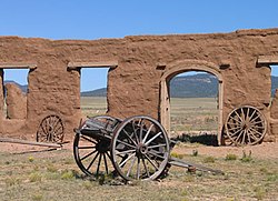 | Missouri, Kansas, Oklahoma, Colorado, New Mexico | NPS | 1987 | 1,203 mi (1,940 km) | William Becknell made the first trade trip from Missouri to Santa Fe in 1821, when newly independent Mexico welcomed commerce. It was a major exchange route between the two countries for the next 25 years when the Army of the West used it in the Mexican–American War. After the war ended in 1848, emigration and freight to the new southwest flourished. The Atchison, Topeka and Santa Fe Railway reached Santa Fe via Raton Pass in 1880, replacing the trade caravans. Significant sites include Fort Larned, Bent's Old Fort, and Fort Union (pictured), where wagon ruts can still be seen. [50] |
|---|
| Selma to Montgomery |  | Alabama | NPS | 1996 | 54 mi (90 km) | The 1965 Selma to Montgomery marches were nonviolent demonstrations of the civil rights movement pushing for the Voting Rights Act. Led by John Lewis and Hosea Williams, 600 marchers were brutally attacked by state police at Selma's Edmund Pettus Bridge (pictured), rousing national support for the bill. Another march a month later saw the protestors complete the four-day walk from Brown Chapel A.M.E. Church to the Alabama State Capitol, where Martin Luther King Jr. spoke before a crowd of 25,000. The trail has historical markers and three interpretive centers. [51] |
|---|
| Star-Spangled Banner |  | Maryland, Virginia, District of Columbia | NPS | 2008 | 290 mi (470 km) | This water and land trail highlights the history of the War of 1812 in the Chesapeake Bay Region. Major sites of this three-year war between the United States and United Kingdom include raided towns Havre de Grace and Saint Michaels; grounds of the Battle of Bladensburg and Battle of North Point; and Fort McHenry National Monument and Historic Shrine (pictured), where the flying of the American flag in the Battle of Baltimore inspired "The Star-Spangled Banner". [52] |
|---|
| Trail of Tears |  | Georgia, North Carolina, Tennessee, Alabama, Kentucky, Illinois, Missouri, Arkansas, Oklahoma | NPS | 1987 | 5,045 mi (8,120 km) | The 1830 Indian Removal Act forced tens of thousands of Cherokee, Muscogee, Seminole, Chickasaw, and Choctaw people to leave their ancestral homelands in the Southeast and relocate to Indian Territory (now Oklahoma). Around ten thousand Indians died of disease or the elements on their journeys. This trail commemorates the routes taken by the Cherokee after they were evicted and detained in camps by the Army in 1838, making the four-month trek over the winter. Historic sites include the Cherokee capital New Echota in Georgia (pictured), Chief John Ross's log cabin, Red Clay State Park, Rattlesnake Springs, and several museums. [53] |
|---|
Washington–Rochambeau
Revolutionary Route |  | Rhode Island, Connecticut, New York, New Jersey, Pennsylvania, Delaware, Maryland, Virginia, District of Columbia, Massachusetts | NPS | 2009 | 1,000 mi (1,610 km) | Six years into the Revolutionary War, the French Expédition Particulière commanded by the comte de Rochambeau departed Newport, Rhode Island, to meet George Washington's Continental Army at Dobbs Ferry, New York, in June 1781. They marched to Williamsburg, Virginia, over the next few months, stopping at the Old Barracks in Trenton and Mount Vernon. In the three-week siege of Yorktown (now part of Colonial National Historical Park, reenactment pictured) they defeated General Cornwallis's army, soon clinching independence for the 13 colonies. Several campsites and homes on their route are preserved, including the Joseph Webb House where Washington and Rochambeau made plans for the campaign. [54] |
|---|