The Jamestown settlement in the Colony of Virginia was the first permanent English settlement in the Americas. It was located on the northeast bank of the James River, about 2.5 mi (4 km) southwest of present-day Williamsburg. It was established by the London Company as "James Fort" on May 4, 1607 O.S., and considered permanent, after brief abandonment in 1610. It followed failed attempts, including the Roanoke Colony, established in 1585. Despite the dispatch of more supplies, only 60 of the original 214 settlers survived the 1609–1610 Starving Time. In mid-1610, the survivors abandoned Jamestown, though they returned after meeting a resupply convoy in the James River.

Jamestown Settlement is a living history museum operated by the Commonwealth of Virginia, created in 1957 as Jamestown Festival Park for the 350th anniversary celebration. Today it includes a recreation of the original James Fort, a Powhatan Native American town, indoor and outdoor displays, and replicas of the original settlers' ships: the Susan Constant, Godspeed, and Discovery.

York County is a county in the eastern part of the Commonwealth of Virginia, located in the Tidewater. As of the 2020 census, the population was 70,045. The county seat is the unincorporated town of Yorktown.

Williamsburg is an independent city in Virginia, United States. As of the 2020 census, it had a population of 15,425. Located on the Virginia Peninsula, Williamsburg is in the northern part of the Hampton Roads metropolitan area. It is bordered by James City County on the west and south and York County on the east.

James City County is a county located in the Commonwealth of Virginia. As of the 2020 census, the population was 78,254. Although politically separate from the county, the county seat is the adjacent independent city of Williamsburg.

Yorktown is a census-designated place (CDP) in York County, Virginia. It is the county seat of York County, one of the eight original shires formed in colonial Virginia in 1682. Yorktown's population was 195 as of the 2010 census, while York County's population was 66,134 in the 2011 census estimate.

Hampton Roads is the name of a body of water in the United States that serves as a wide channel for the James, Nansemond, and Elizabeth rivers between Old Point Comfort and Sewell's Point near where the Chesapeake Bay flows into the Atlantic Ocean. It also gave its name to the surrounding metropolitan region located in the southeastern Virginia and northeastern North Carolina portions of the Tidewater Region.

The Virginia Peninsula is located in southeast Virginia, bounded by the York River, James River, Hampton Roads and Chesapeake Bay. It is sometimes known as the Lower Peninsula to distinguish it from two other peninsulas to the north, the Middle Peninsula and the Northern Neck.
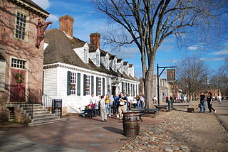
Colonial Williamsburg is a living-history museum and private foundation presenting a part of the historic district in the city of Williamsburg, Virginia. Its 301-acre (122 ha) historic area includes several hundred restored or recreated buildings from the 18th century, when the city was the capital of the Colony of Virginia; 17th-century, 19th-century, and Colonial Revival structures; and more recent reconstructions. The historic area includes three main thoroughfares and their connecting side streets that attempt to suggest the atmosphere and the circumstances of 18th-century Americans. Costumed employees work and dress as people did in the era, sometimes using colonial grammar and diction.

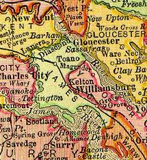
Colonial Parkway is a 23-mile (37 km) scenic parkway linking the three points of Virginia's Historic Triangle, Jamestown, Williamsburg, and Yorktown. It is part of the National Park Service's Colonial National Historical Park. Virginia's official state classification for the parkway is State Route 90003. With portions built between 1930 and 1957, it links the three communities via a roadway shielded from views of commercial development. The roadway is toll-free, is free of semi trucks, and has speed limits of around 35 to 45 mph. As a National Scenic Byway and All-American Road, it is also popular with tourists due to the James River and York River ends of the parkway.

Founded in 1889, the Association for the Preservation of Virginia Antiquities was the United States' first statewide historic preservation group. In 2003 the organization adopted the new name APVA Preservation Virginia to reflect a broader focus on statewide Preservation and in 2009 it shortened its name to Preservation Virginia. Preservation Virginia owns historic sites across Virginia including Historic Jamestowne, located at Jamestown, Virginia, site of the first permanent English settlement in North America, and the Cape Henry Light house, one of the first public works projects of the United States of America.

Bruton Parish Church is located in the restored area of Colonial Williamsburg in Williamsburg, Virginia, United States. It was established in 1674 by the consolidation of two previous parishes in the Virginia Colony, and remains an active Episcopal parish. The building, constructed 1711–15, was designated a National Historic Landmark in 1970 as a well-preserved early example of colonial religious architecture.
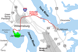
The Historic Triangle includes three historic colonial communities located on the Virginia Peninsula, bounded by the York River on the north and James River on the south. The three points that form the triangle are Jamestown, Colonial Williamsburg, and Yorktown. They feature many restored attractions and are linked by the Colonial Parkway in James City and York counties, and the City of Williamsburg.
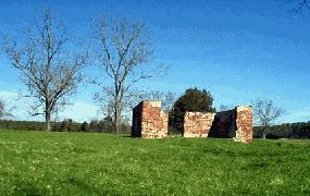
Green Spring Plantation in James City County about five miles (8.0 km) west of Williamsburg, was the 17th century plantation of one of the most unpopular governors of Colonial Virginia in North America, Sir William Berkeley, and his wife, Frances Culpeper Berkeley.
Grove is an unincorporated community in the southeastern portion of James City County in the Virginia Peninsula subregion of Virginia in the United States. It is located in the center of the Historic Triangle of Colonial Virginia, communities linked by the Colonial Parkway. This area is one of the busiest tourist destinations in the world.

Carter's Grove, also known as Carter's Grove Plantation, is a 750-acre (300 ha) plantation located on the north shore of the James River in the Grove Community of southeastern James City County in the Virginia Peninsula area of the Hampton Roads region of Virginia in the United States.

Historic Jamestown is the cultural heritage site that was the location of the 1607 James Fort and the later 17th-century town of Jamestown in America. It is located on Jamestown Island, on the James River at Jamestown, Virginia, and operated as a partnership between Preservation Virginia and the U.S. National Park Service as part of Colonial National Historical Park.

College Creek is located in James City County in the Virginia Peninsula area of the Hampton Roads region of southeastern Virginia in the United States. From a point of origin near the independent city of Williamsburg, it is a tributary of the James River.
The city of Williamsburg, Virginia has a full range of transport facilities. Williamsburg is served by the Newport News/Williamsburg International Airport, and by two larger but more distant airports. The city is linked to several Interstate and State highways. A transport hub - the Williamsburg Transportation Center - serves bus and rail passengers. Motor traffic is restricted in the historic area, and the city as a whole is more "walkable" than the US norm. Cycling routes are also being provided.

The history of Hampton Roads dates to 1607, when Jamestown was founded. Two wars have taken place in addition to many other historical events.