
Accomack County is a United States county located in the eastern edge of the Commonwealth of Virginia. Together, Accomack and Northampton counties make up the Eastern Shore of Virginia, which in turn is part of the Delmarva Peninsula, bordered by the Chesapeake Bay and the Atlantic Ocean. The Accomack county seat is the town of Accomac.

Cape Charles is a town / municipal corporation in Northampton County, Virginia, United States. The population was 1,009 as of the 2010 U.S.Decennial Census.

The Northern Neck is the northernmost of three peninsulas on the western shore of the Chesapeake Bay in the Commonwealth of Virginia. This peninsula is bounded by the Potomac River on the north and the Rappahannock River on the south. It encompasses the following Virginia counties: Lancaster, Northumberland, Richmond, and Westmoreland.

The Middle Peninsula is the second of three large peninsulas on the western shore of Chesapeake Bay in Virginia, in the United States. It lies between the Northern Neck and the Virginia Peninsula. This peninsula is bounded by the Rappahannock River on the north and the York River on the south, with the Chesapeake Bay to the east. It encompasses six Virginia counties: Essex, Gloucester, King and Queen, King William, Mathews, and Middlesex. Developed for tobacco plantations in the colonial era, in the 21st century the Middle Peninsula is known for its quiet rural life, vegetable truck-farming, and fishing industry.

Busch Field is a stadium on the campus of the College of William and Mary located in Williamsburg, Virginia. It is currently used by the college's field hockey team for home games, as well as many intramural and club sport contests. There are two fields in the designated "Busch Field" area. One is composed of artificial turf while the other is entirely natural grass. The name for the stadium comes from Anheuser-Busch, formerly the largest American brewer. Anheuser-Busch has a large presence in the Williamsburg area, including a brewery and the theme park Busch Gardens Williamsburg. Adjacent to Busch Field are the Busch Tennis Courts, also sponsored by the company.

Buckroe Beach is a neighborhood in the independent city of Hampton, Virginia. It lies just north of Fort Monroe on the Chesapeake Bay. One of the oldest recreational areas in the state, it was long located in Elizabeth City County near the downtown area of the lost town of Phoebus prior to their consolidation with Hampton in 1952.

Tin Town is an unincorporated community in southeastern Polk County, Missouri, United States, located on Route 215.
New Point Comfort is a point of land located in Mathews County at the tip of Virginia's Middle Peninsula in the lower Chesapeake Bay in the United States. It is the site of the New Point Comfort Natural Area Preserve and the New Point Comfort Light.

Sheatown is a census-designated place (CDP) in Newport Township, Luzerne County, Pennsylvania, United States. It is adjacent to the west side of the city of Nanticoke. The population of Sheatown was 671 at the 2010 census.

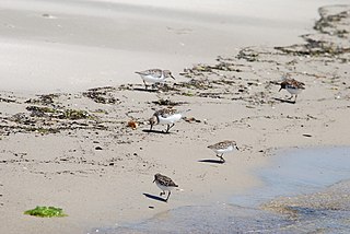
Bethel Beach Natural Area Preserve is a 105-acre (42 ha) Natural Area Preserve located in Mathews County, Virginia, near the Chesapeake Bay. It contains beach, low dune, and salt marsh habitats, and provides a haven for rare marsh and colonial nesting birds, The preserve also protects habitat for two globally rare species, the northeastern beach tiger beetle and sea-beach knotweed.
Cape Charles Coastal Habitat Natural Area Preserve is a 29-acre (12 ha) Natural Area Preserve located in Northampton County, Virginia on the Chesapeake Bay side of Virginia's Eastern Shore. The small preserve protects coastal beach, dune, and maritime forest habitat, preserving a home for the northeastern beach tiger beetle, listed as threatened in the United States. Coast bedstraw grows on the dunes. The preserve serves as a staging area for southward-bound migratory birds in the fall.
Cumberland Marsh Natural Area Preserve is a Natural Area Preserve located in New Kent County, Virginia near the Cumberland Hospital Children-Adolescents. Owned by the Nature Conservancy, it preserves 1,193 acres (4.83 km2) of freshwater tidal marsh along the Pamunkey River, providing habitat for bald eagles, osprey, blue herons, and egrets, as well as for the sensitive joint-vetch. It is an important habitat for wintering waterfowl as well.
Magothy Bay Natural Area Preserve is a 286-acre (1.16 km2) Natural Area Preserve located in Northampton County, Virginia. The preserve encompasses woodlands, wetlands, and salt marshes, providing foraging areas for various species of waterfowl, shorebirds, and wading birds. Diamondback terrapins and clapper rails are frequent visitors, as are many varieties of songbird.
Savage Neck Dunes Natural Area Preserve is a 298-acre (121 ha) Natural Area Preserve located in Northampton County, Virginia on the Chesapeake Bay. Fifty-foot-tall (15 m) dunes within the preserve are among the highest points on Virginia's Eastern Shore. The preserve contains beach, dune, and maritime forest natural communities of various sorts, as well as habitat for migratory songbirds and northeastern beach tiger beetles. Regionally rare plants at the preserve include Engelmann's umbrella-sedge, dwarf burhead, and southern bladderwort.
Wreck Island Natural Area Preserve is a 1,380-acre (5.6 km2) Natural Area Preserve located in Northampton County, Virginia. One of the Virginia Barrier Islands, it protects various marsh, beach, grassland, dune, and shrubland habitats. It was designated as part of the National Audubon Society's "Barrier Island/Lagoon System Important Bird Area" for its importance as a nursery for nesting bird colonies. The island, which is slowly migrating towards the mainland, formerly featured dune-like mounds of shells which were destroyed by Hurricane Isabel.
Old Trower is an unincorporated community in Accomack County, Virginia.
Chesapeake is an unincorporated community in Northampton County, Virginia, United States.


