James River National Wildlife Refuge

Last updated

James River National Wildlife Refuge
IUCN category IV (habitat/species management area)
James River National Wildlife Refuge, VA. Credit- USFWS (11821430384).jpg
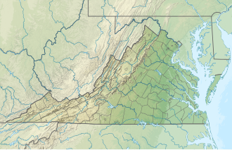
USA Virginia relief location map.svg
Red pog.svg
Usa edcp relief location map.png
Red pog.svg
Location Prince George County, Virginia, United States
Nearest city Hopewell, Virginia
Coordinates 37°16′03″N77°07′45″W / 37.26750°N 77.12917°W / 37.26750; -77.12917
Area4,200 acres (17 km2)
Established1991
Governing body U.S. Fish and Wildlife Service
Website James River National Wildlife Refuge

The James River National Wildlife Refuge is a National Wildlife Refuge located along the James River in eastern Prince George County, Virginia. Its management is overseen by the United States Fish and Wildlife Service.

Contents

One of four refuges that comprise the Eastern Virginia Rivers National Wildlife Refuge Complex, James River National Wildlife Refuge was founded in 1991 to protect nesting and roosting habitat of the bald eagle from development. The refuge's 4,200 acres (17 km2) of forest and wetlands are bordered by Powell Creek to the west, and by Flowerdew A Hundred Plantation to the east.

The land that is now the refuge was the site of Powellbrooke Plantation, whose owner Captain Nathaniel Powell (one of the original 1607 colonists), his wife, and ten others were killed during the Indian massacre of 1622, and later Merchant's Hope Plantation during colonial times.
Ecology & Wildlife Management

Various research and land management projects are active at James River NWR. Including monitoring bird species like Bald Eagles, monitoring arthropod species like endangered Frosted Elfin, and working to restore longleaf pine savannah, an exceedingly rare habitat in Virginia. Longleaf pine restoration has predominantly amounted to cutting down small sections of current loblolly stands, planting longleaf pine and regularly burning the experimental plot in order to control for longleaf dominance. [1]

Related Research Articles

<span class="mw-page-title-main">Longleaf pine</span> Species of plant (tree)

The longleaf pine is a pine species native to the Southeastern United States, found along the coastal plain from East Texas to southern Virginia, extending into northern and central Florida. In this area it is also known as "yellow pine" or "long leaf yellow pine", although it is properly just one out of a number of species termed yellow pine. It reaches a height of 30–35 m (98–115 ft) and a diameter of 0.7 m (28 in). In the past, before extensive logging, they reportedly grew to 47 m (154 ft) with a diameter of 1.2 m (47 in). The tree is a cultural symbol of the Southern United States, being the official state tree of Alabama. This particular species is one of the eight pine tree species that falls under the "Pine" designation as the state tree of North Carolina.

Montezuma National Wildlife Refuge is a wildlife preserve operated by the United States Fish and Wildlife Service, encompassing part of the Montezuma Swamp at the north end of Cayuga Lake. The 10,004-acre (40.48 km2) preserve is composed of swamps, pools and channels and is a stopping point for migratory birds. It is the largest contiguous wetland complex in the northeastern United States and comprises a portion of the larger Montezuma Wetlands Complex, which is a partnership between the USFWS, the New York State Department of Environmental Conservation, as well as several other non-profit support organizations.

<span class="mw-page-title-main">Piney Woods</span> Temperate coniferous forests ecoregion of the United States

The Piney Woods is a temperate coniferous forest terrestrial ecoregion in the Southern United States covering 54,400 square miles (141,000 km2) of East Texas, southern Arkansas, western Louisiana, and southeastern Oklahoma. These coniferous forests are dominated by several species of pine as well as hardwoods including hickory and oak. Historically the most dense part of this forest region was the Big Thicket though the lumber industry dramatically reduced the forest concentration in this area and throughout the Piney Woods during the 19th and 20th centuries. The World Wide Fund for Nature considers the Piney Woods to be one of the critically endangered ecoregions of the United States. The United States Environmental Protection Agency (EPA) defines most of this ecoregion as the South Central Plains.

<span class="mw-page-title-main">Missisquoi National Wildlife Refuge</span>

Missisquoi National Wildlife Refuge is a National Wildlife Refuge in the U.S. state of Vermont located on the eastern shore of Lake Champlain and the southern side of Missisquoi Bay. The refuge is in Franklin County in the northwest corner of the state near the International Boundary with Canada.

<span class="mw-page-title-main">Lower Suwannee National Wildlife Refuge</span> Refuge on the western coast of Florida, U.S.

The Lower Suwannee National Wildlife Refuge (LSNWR) is part of the United States National Wildlife Refuge System. It is located in southeastern Dixie and northwestern Levy counties on the western coast of Florida, approximately fifty miles southwest of the city of Gainesville.

<span class="mw-page-title-main">Lower Klamath National Wildlife Refuge</span> Wildlife refuge and National Historic Landmark in northern California, United States

The Lower Klamath National Wildlife Refuge is a National Wildlife Refuge of the United States on the border between California and Oregon. It is operated by the United States Fish and Wildlife Service. The refuge was designated a National Historic Landmark on October 16, 1965.

<span class="mw-page-title-main">Okefenokee National Wildlife Refuge</span> Nature center in Folkston, Georgia, US

The Okefenokee National Wildlife Refuge is a 402,000‑acre (1,627 km2) National Wildlife Refuge located in Charlton, Ware, and Clinch Counties of Georgia, and Baker County in Florida, United States. The refuge is administered from offices in Folkston, Georgia. The refuge was established in 1937 to protect a majority of the 438,000 acre (1,772 km2) Okefenokee Swamp. Though often translated as "land of trembling earth", the name "Okefenokee" is likely derived from Hitchiti oki fanôːki "bubbling water".

<span class="mw-page-title-main">Florida Trail</span> A US National Scenic trail

The Florida Trail is one of eleven National Scenic Trails in the United States, created by the National Trails System Act of 1968. It runs 1,500 miles (2,400 km), from Big Cypress National Preserve to Fort Pickens at Gulf Islands National Seashore, Pensacola Beach. Also known as the Florida National Scenic Trail, the trail provides permanent non-motorized recreation for hiking and other compatible activities within an hour's drive of most Floridians.

<span class="mw-page-title-main">Mason Neck, Virginia</span> Census-designated place in Virginia, United States

Mason Neck is a peninsula jutting into the Potomac River in Fairfax County, Virginia, southwest of Washington, D.C.. It is surrounded by Belmont Bay to the west, the Potomac River to the south and east, Gunston Cove to the northeast, and Pohick Bay to the north-northeast. Mason Neck forms the southernmost section of Fairfax County in Northern Virginia. It comprises an area of 20.0 square miles (51.8 km2), two-thirds of which is preserved as parkland by regional, state, and national authorities. The population of the Mason Neck CDP was 2,005 as of the 2010 census.

<span class="mw-page-title-main">Atlantic Flyway</span> Major north-south flyway for migratory birds in North America

The Atlantic Flyway is a major north-south flyway for migratory birds in North America. The route generally starts in Greenland, then follows the Atlantic coast of Canada, then south down the Atlantic Coast of the United States to the tropical areas of South America and the Caribbean. Every year, migratory birds travel up and down this route following food sources, heading to breeding grounds, or traveling to overwintering sites.

<span class="mw-page-title-main">Waccamaw National Wildlife Refuge</span> United States National Wildlife Refuge in South Carolina

Waccamaw National Wildlife Refuge, established in 1997, is a recent addition to the United States National Wildlife Refuge system. It is located in parts of northeastern Georgetown County, South Carolina, southern Horry, and southeastern Marion counties, and contains lands adjacent to the Pee Dee River, the Little Pee Dee River, and the Waccamaw River near their confluence. Currently the size of the refuge is 22,931 acres (92.80 km2) but plans call for the total refuge to be over 50,000 acres (200 km2).

<span class="mw-page-title-main">Lake George State Forest</span> State forest in Florida, United States

The Lake George State Forest is a designated protected area and state forest in the U.S. state of Florida. The 21,176-acre (8,570 ha) forest is located in northwestern Volusia County, Florida, near Lake George and the communities of Pierson, Barberville, and Volusia. It is overseen by the Florida Forest Service within the Florida Department of Agriculture and Consumer Services.

<span class="mw-page-title-main">Presquile National Wildlife Refuge</span> United States National Wildlife Refuge in Virginia

Presquile National Wildlife Refuge in the U.S. state of Virginia is one of four refuges that make up the Eastern Virginia Rivers National Wildlife Refuge Complex. It is managed by the United States Fish and Wildlife Service. The refuge is a 1,329-acre (5.38 km2) island in the James River, located approximately 20 miles (32 km) south of Richmond. It is located in the easternmost part of Chesterfield County, northeast of Hopewell.

<span class="mw-page-title-main">Carolina Sandhills National Wildlife Refuge</span> United States National Wildlife Refuge in South Carolina

The Carolina Sandhills National Wildlife Refuge is a 45,348-acre (183.52 km2) national wildlife refuge (NWR) located in Chesterfield County, South Carolina. The refuge is managed by the U.S. Fish and Wildlife Service from a headquarters located in McBee, South Carolina. The refuge is served by U.S. Highway 1, which passes through it.

<span class="mw-page-title-main">Moosehorn National Wildlife Refuge</span>

Moosehorn National Wildlife Refuge is one of the northernmost National Wildlife Refuges in the Atlantic Flyway, a migratory route that follows the eastern coast of North America. The refuge provides important feeding and nesting habitat for many bird species, including waterfowl, wading birds, shorebirds, upland game birds, songbirds, and birds of prey.

<span class="mw-page-title-main">Eastern Neck National Wildlife Refuge</span>

Eastern Neck National Wildlife Refuge, a part of the Chesapeake Marshlands National Wildlife Refuge Complex, is a 2,286-acre (9.25 km2) island located at the confluence of the Chester River and the Chesapeake Bay. Established in 1962 as a sanctuary for migratory birds, Eastern Neck National Wildlife Refuge provides natural habitat for over 240 bird species — including bald eagles and transitory peregrine falcons — and is a major staging site for tundra swans.

<span class="mw-page-title-main">Patuxent Research Refuge</span> United States Fish and Wildlife Service operated wildlife refuge in Maryland

The Patuxent Research Refuge is a National Wildlife Refuge in Prince George's County, Maryland, United States, established in 1936 by executive order of President Franklin D. Roosevelt. It is the only National Wildlife Refuge in the country established to support wildlife research. With land surrounding the Patuxent and Little Patuxent Rivers between Washington, D.C., and Baltimore, Maryland, the refuge has grown from the original 2,670 acres (10.8 km2) to its present size of over 12,800 acres (52 km2) and encompasses land formerly managed by the Departments of Agriculture and Defense. Throughout decades of change, Patuxent's mission of conserving and protecting the nation's wildlife and habitat through research and wildlife management techniques has remained virtually unchanged.

<span class="mw-page-title-main">Mackay Island National Wildlife Refuge</span> United States National Wildlife Refuge in Virginia

Mackay Island National Wildlife Refuge was established in 1960 to provide habitat for migratory waterfowl, primarily the greater snow goose. It is located almost entirely on Knotts Island in the Currituck Sound between Back Bay in Virginia Beach, Virginia, and the open sound in North Carolina. Most of the refuge lies within North Carolina but some of it is in Virginia. The refuge is primarily made up of marsh habitat. This area has long been recognized for supporting significant migratory waterfowl populations and sport fishery resources, and is part of the Charles Kuralt Trail.

The Florida Wildlife Corridor (FLWC) is a statewide network of nearly 18 million acres of connected ecosystems containing state parks, national forests, and wildlife management areas that support wildlife and human occupation. The corridor seeks to connect wildlife habitats, reducing their fragmentation and the subsequent declines in plant and animal populations caused by human activities The Florida Wildlife Corridor was conceived by Tom Hoctor, director of the University of Florida's Center for Landscape and Conservation Planning, and Carlton Ward Jr., with further inspiration partly from Lawton Chiles.It is championed by the Florida Wildlife Corridor Foundation and other major organizations, including Walt Disney World. The corridor consists of more than 40% of the state including planned areas of conservation. The FLWC is made possible by a bipartisan law passed in 2021 and involves efforts by government leaders and businessmen as well as conservationist. The initiative also has public support from Florida residents as it also helps to protect privately owned farmland.

<span class="mw-page-title-main">Southern Coastal Plain (ecoregion)</span> Level III ecoregion in the United States

The North American Southern Coastal Plain is a Level III ecoregion designated by the Environmental Protection Agency (EPA) in six U.S. states. The region stretches across the Gulf coast from eastern Louisiana to Florida, forms the majority of Florida, and forms the coastlines of Georgia and much of South Carolina. It has been divided into twelve Level IV ecoregions.

References

  1. "James River National Wildlife Refuge | What We Do - Projects & Research | U.S. Fish & Wildlife Service". www.fws.gov. Retrieved December 20, 2024.

PD-icon.svg This article incorporates public domain material from websites or documents of the United States Fish and Wildlife Service .