The following table lists the ten National Natural Landmarks within Virginia in the eastern United States. They are administered by the United States National Park Service.

Virginia National Natural Landmarks (clickable map)
| Name | Image | Date | Location | County | Ownership | Description |
|---|---|---|---|---|---|---|
| Butler Cave- Breathing Cave | 1973 | Bath | Private | Two major cave systems that contain a 40-foot (12 m) waterfall, a natural bridge, unusually fine crystalline formations, and an underground lake. Access is managed by the Butler Cave Conservation Society. | ||
| Caledon Natural Area | 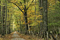 | 1974 | 38°21′09″N77°07′58″W / 38.3525°N 77.132778°W | King George | State (state park) | One of the best examples of oak-tulip poplar-dominated virgin upland forest in the country. |
| Charles C. Steirly Natural Area | 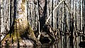 | 1974 | 37°03′03″N76°58′52″W / 37.050833°N 76.981111°W | Sussex | State (Natural Area Preserve) | A small, essentially virgin stand of climax bald cypress-water tupelo swamp forest. |
| Grand Caverns |  | 1973 | 38°15′37″N78°50′07″W / 38.260278°N 78.835278°W | Augusta | Municipal | Contains unique shield formations as well as draperies, flowstone, stalactites and stalagmites. |
| Great Dismal Swamp |  | 1972 | 36°38′27″N76°27′06″W / 36.640876°N 76.451797°W | Suffolk City | Federal (National Wildlife Refuge) | A remnant of the original Great Dismal Swamp. |
| Luray Caverns |  | 1973 | 38°39′52″N78°29′02″W / 38.664306°N 78.483806°W | Page | Private | A cave ornately decorated with cascades, columns, stalactites, stalagmites and pools. |
| Montpelier Forest | 1987 | 38°13′11″N78°10′10″W / 38.219722°N 78.169444°W | Orange | Private | A mature forest dominated primarily by tulip poplar and spicebush, located on the grounds of President James Madison's Montpelier estate. | |
| Rich Hole | 1974 | 37°52′17″N79°38′18″W / 37.871389°N 79.638333°W | Rockbridge | Federal (George Washington National Forest) | An outstanding example of a "cove" hardwood forest. | |
| Seashore Natural Area |  | 1965 | 36°54′22″N76°00′55″W / 36.906111°N 76.015278°W | Virginia Beach | State (state park) | Contains parallel dunes that are densely wooded with two distinct forest types of semitropical character. |
| Virginia Coast Reserve | 1979 | 37°24′59″N75°41′20″W / 37.4163°N 75.689°W | Accomack, Northampton | Private | Relatively undisturbed barrier island-lagoon complex. A refuge for migratory shorebirds, waterfowl and colonial nesting birds. | |