Bedford County, Virginia

Last updated

Bedford County
Courthouse Drone.png
Bedford County Courthouse
Flag of Bedford County, Virginia.png
Bedford County Seal.jpg
Map of Virginia highlighting Bedford County.svg
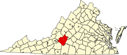
Location within the U.S. state of Virginia
Virginia in United States.svg
Virginia's location within the U.S.
Coordinates: 37°19′N79°32′W / 37.31°N 79.53°W / 37.31; -79.53
CountryFlag of the United States.svg United States
StateFlag of Virginia.svg  Virginia
Founded1754
Named for John Russell, 4th Duke of Bedford
Seat Bedford
Largest townBedford
Area
  Total769 sq mi (1,990 km2)
  Land753 sq mi (1,950 km2)
  Water16 sq mi (40 km2)  2.1%
Population
 (2020)
  Total79,462
  Density100/sq mi (40/km2)
Time zone UTC−5 (Eastern)
  Summer (DST) UTC−4 (EDT)
Congressional districts 5th, 9th
Website www.bedfordcountyva.gov

Bedford County is a United States county located in the Piedmont region of the Commonwealth of Virginia. Its county seat is the town of Bedford, which was an independent city from 1968 until rejoining the county in 2013. [1]

Contents

Bedford County was created in 1753 from parts of Lunenburg County, and several changes in alignment were made until the present borders were established in 1786. The county was named in honor of John Russell, an English statesman and fourth Duke of Bedford.

Bedford County is part of the Lynchburg Metropolitan Statistical Area. As of the 2020 census, Bedford's population was 79,462. [2] The county population has more than doubled since 1980. [3]

History

John Russell, 4th Duke of Bedford, for whom the county was named 4thDukeOfBedford.jpg
John Russell, 4th Duke of Bedford, for whom the county was named

The Piedmont area had long been inhabited by indigenous peoples. At the time of European encounter, mostly Siouan-speaking tribes lived in this area.

Bedford County was established by the Virginia General Assembly on December 13, 1753, from parts of Lunenburg County. [4] Later in 1756, a portion of Albemarle County lying south of the James River was added. The county is named for John Russell, the fourth Duke of Bedford, who was a Secretary of State of Great Britain. [5] In 1782, Campbell County was formed from eastern Bedford County and the county seat was moved from New London to Liberty (now Bedford). Also in 1786, the portion of Bedford County south of the Staunton (Roanoke) River was taken with part of Henry County to form Franklin County.

The town of Bedford became an independent city in 1968, and remained the county seat. On September 14, 2011, the Bedford City Council voted to transition into a town and end its independent city status. The supervisors of Bedford County also voted to accept the town of Bedford as part of the county when it lost city status. The town of Bedford once more became part of Bedford County on July 1, 2013. [6]

Geography

According to the U.S. Census Bureau, the county has a total area of 769 square miles (1,990 km2), of which 753 square miles (1,950 km2) is land and 16 square miles (41 km2) (2.1%) is water. [7]

Adjacent counties and city

National protected areas

State Park

Major highways

Demographics

Historical population
CensusPop.Note
1790 10,531
1800 14,12534.1%
1810 16,14814.3%
1820 19,30519.6%
1830 20,2464.9%
1840 20,203−0.2%
1850 24,08019.2%
1860 25,0684.1%
1870 25,3271.0%
1880 31,20523.2%
1890 31,2130.0%
1900 30,356−2.7%
1910 29,549−2.7%
1920 30,6693.8%
1930 29,091−5.1%
1940 29,6872.0%
1950 29,627−0.2%
1960 31,0284.7%
1970 26,728−13.9%
1980 34,92730.7%
1990 45,65630.7%
2000 60,37132.2%
2010 68,67613.8%
2020 79,46215.7%
U.S. Decennial Census [10]
1790-1960 [11] 1900-1990 [12]
1990-2000 [13] 2010 [14] 2020 [15]

2020 census

Bedford County, Virginia – Racial and ethnic composition
Note: the US Census treats Hispanic/Latino as an ethnic category. This table excludes Latinos from the racial categories and assigns them to a separate category. Hispanics/Latinos may be of any race.
Race / Ethnicity (NH = Non-Hispanic)Pop 2010 [14] Pop 2020 [15] % 2010% 2020
White alone (NH)62,03568,12890.33%85.74%
Black or African American alone (NH)3,9094,8645.69%6.12%
Native American or Alaska Native alone (NH)1721670.25%0.21%
Asian alone (NH)7009671.02%1.22%
Pacific Islander alone (NH)14330.02%0.04%
Some Other Race alone (NH)473290.07%0.41%
Mixed Race or Multi-Racial (NH)7092,9191.03%3.67%
Hispanic or Latino (any race)1,0902,0551.59%2.59%
Total68,67679,462100.00%100.00%

2000 Census

As of the census [16] of 2000, there were 60,371 people, 23,838 households, and 18,164 families residing in the county. The population density was 80 people per square mile (31 people/km2). There were 26,841 housing units at an average density of 36 units per square mile (14 units/km2). The racial makeup of the county was 92.18% White, 6.24% Black or African American, 0.20% Native American, 0.43% Asian, 0.01% Pacific Islander, 0.20% from other races, and 0.74% from two or more races. 0.74% of the population were Hispanic or Latino of any race. 28.2% were of American, 15.6% English, 11.0% German and 9.6% Irish ancestry according to Census 2000.

There were 23,838 households, out of which 32.50% had children under the age of 18 living with them, 65.40% were married couples living together, 7.50% had a female householder with no husband present, and 23.80% were non-families. 20.20% of all households were made up of individuals, and 7.30% had someone living alone who was 65 years of age or older. The average household size was 2.52 and the average family size was 2.89.

In the county, the population's age distribution was: 24.00% under the age of 18, 5.80% from 18 to 24, 29.90% from 25 to 44, 27.50% from 45 to 64, and 12.80% who were 65 years of age or older. The median age was 40 years. For every 100 females there were 99.50 males. For every 100 females age 18 and over, there were 97.50 males.

The median income for a household in the county was $43,136, and the median income for a family was $49,303. Males had a median income of $35,117 versus $23,906 for females. The per capita income for the county was $21,582. About 5.20% of families and 7.10% of the population were below the poverty line, including 8.30% of those under age 18 and 10.50% of those age 65 or over.

2017

As of 2017, the largest self-reported ancestry groups were: [17]

Government

Board of Supervisors

Constitutional officers

Bedford County is represented by Republican Mark Peake (8th District) in the Virginia Senate; Republicans Eric Zehr (51st District) and Tim Griffin (53rd District) in the Virginia House of Delegates; and Republicans Bob Good (VA 5th District), Ben Cline (VA 6th District), and Morgan Griffith (VA 9th District) in the U.S. House of Representatives.

Economy

Historically, Bedford County was an agricultural economy. While agriculture is still an important factor in the county's economy, Bedford County has significant residential development to serve Lynchburg, Roanoke, and Smith Mountain Lake. Tourism and retail are also becoming more significant with some new industry near Forest and New London.

Politics

Bedford has voted Republican in every presidential election since 1980. Like much of the Solid South, it was a reliably Democratic county until 1948, when Strom Thurmond's candidacy reduced Harry S. Truman's victory, and it was a swing county for the next three decades. It voted for segregationist third-party candidate George Wallace for president in 1968.

United States presidential election results for Bedford County, Virginia [18]
Year Republican Democratic Third party
No.%No.%No.%
2020 35,60073.15%12,17625.02%8931.83%
2016 30,65972.10%9,76822.97%2,0984.93%
2012 26,67971.29%10,20927.28%5371.43%
2008 24,42068.16%11,01730.75%3931.10%
2004 21,92569.82%9,10228.98%3771.20%
2000 17,22465.87%8,16031.21%7652.93%
1996 11,95554.07%7,78635.22%2,36810.71%
1992 10,49650.57%6,79232.72%3,46816.71%
1988 10,70265.33%5,40633.00%2741.67%
1984 10,37168.15%4,75431.24%920.60%
1980 6,60855.81%4,72139.87%5114.32%
1976 4,18945.31%4,76651.55%2913.15%
1972 5,28673.43%1,50120.85%4125.72%
1968 2,80735.80%1,57420.08%3,45944.12%
1964 3,80648.09%4,07651.50%320.40%
1960 2,91147.87%3,15051.80%200.33%
1956 3,14852.07%2,64943.81%2494.12%
1952 2,91654.47%2,42645.32%110.21%
1948 1,08430.04%1,55643.11%96926.85%
1944 1,06829.60%2,53470.23%60.17%
1940 79123.68%2,53575.90%140.42%
1936 61921.30%2,27678.32%110.38%
1932 46916.57%2,32181.99%411.45%
1928 1,11843.77%1,43656.23%00.00%
1924 43219.00%1,81179.64%311.36%
1920 58324.49%1,77474.51%241.01%
1916 29815.38%1,62884.05%110.57%
1912 1428.19%1,21970.34%37221.47%

Attractions

Communities

Town

Census-designated places

Other unincorporated communities

Some of these unincorporated areas have mailing addresses in Bedford town and Lynchburg.

Notable people

See also

Related Research Articles

<span class="mw-page-title-main">Franklin County, Florida</span> County in Florida, United States

Franklin County is a county along the Gulf of Mexico in the panhandle of the U.S. state of Florida. As of the 2020 census, the population was 12,451, making it the third-least populous county in Florida. The county seat is Apalachicola.

<span class="mw-page-title-main">Bedford, Virginia</span> Incorporated town in Virginia, United States

Bedford is an incorporated town and former independent city located within Bedford County in the U.S. state of Virginia. It serves as the county seat of Bedford County. As of the 2020 census, the population was 6,657. It is part of the Lynchburg Metropolitan Statistical Area.

<span class="mw-page-title-main">Inyo County, California</span> County in California, United States

Inyo County is a county in the eastern central part of the U.S. state of California, located between the Sierra Nevada and the state of Nevada. In the 2020 census, the population was 19,016. The county seat is Independence. Inyo County is on the east side of the Sierra Nevada and southeast of Yosemite National Park in Central California. It contains the Owens River Valley; it is flanked to the west by the Sierra Nevada and to the east by the White Mountains and the Inyo Mountains. With an area of 10,192 square miles (26,400 km2), Inyo is the second-largest county by area in California, after San Bernardino County. Almost one-half of that area is within Death Valley National Park. However, with a population density of 1.8 people per square mile, it also has the second-lowest population density in California, after Alpine County.

<span class="mw-page-title-main">Nicholas County, West Virginia</span> County in West Virginia, United States

Nicholas County is a county located in the central region of U.S. state of West Virginia. As of the 2020 census, the population was 24,604. Its county seat is Summersville. The county was created in 1818 by the Virginia General Assembly and named for Virginia Governor Wilson Cary Nicholas.

<span class="mw-page-title-main">Wythe County, Virginia</span> County in Virginia, United States

Wythe County is a county located in the southwestern part of the U.S. state of Virginia. As of the 2020 census, the population was 28,290. Its county seat is Wytheville.

<span class="mw-page-title-main">Roanoke County, Virginia</span> County in Virginia, United States

Roanoke County is a county located in the U.S. state of the Commonwealth of Virginia. As of the 2020 census, the population was 96,929. Its county seat is Salem, but the county administrative offices are located in the census-designated place of Cave Spring.

<span class="mw-page-title-main">Lynchburg, Virginia</span> Independent city in Virginia, United States

Lynchburg is an independent city in the Commonwealth of Virginia in the United States. First settled in 1757 by ferry owner John Lynch, the city's population was 79,009 at the 2020 census, making Lynchburg the 11th most populous city in Virginia. Located in the foothills of the Blue Ridge Mountains along the banks of the James River, Lynchburg is known as the "City of Seven Hills" or the "Hill City". In the 1860s, Lynchburg was the only city in Virginia that was not recaptured by the Union before the end of the American Civil War.

<span class="mw-page-title-main">Dickenson County, Virginia</span> County in Virginia, United States

Dickenson County is a county located in the Commonwealth of Virginia. As of the 2020 census, the population was 14,124. Its county seat is Clintwood.

<span class="mw-page-title-main">Craig County, Virginia</span> County in Virginia, United States

Craig County is a county located in the Commonwealth of Virginia. As of the 2020 census, the population was 4,892. Its county seat is New Castle.

<span class="mw-page-title-main">Campbell County, Virginia</span> County in Virginia, United States

Campbell County is a United States county situated in the south central part of the Commonwealth of Virginia. Located in the Piedmont region of Virginia, Campbell borders the Blue Ridge Mountains. The county seat is Rustburg.

<span class="mw-page-title-main">Botetourt County, Virginia</span> County in Virginia, United States

Botetourt County is a US county that lies in the Roanoke Region of Virginia. Located in the mountainous portion of the state, the county is bordered by two major ranges, the Blue Ridge Mountains and the Appalachian Mountains.

<span class="mw-page-title-main">Bland County, Virginia</span> County in Virginia, United States

Bland County is a county located in the southwestern portion of the Commonwealth of Virginia. The county seat is the unincorporated area of Bland. At the 2020 census, the population was 6,270.

<span class="mw-page-title-main">Bath County, Virginia</span> County in Virginia, United States

Bath County is a United States county on the central western border of the Commonwealth of Virginia, on the West Virginia state line. As of the 2020 census, the population was 4,209, the second-least populous county in Virginia. Bath's county seat is Warm Springs.

<span class="mw-page-title-main">Appomattox County, Virginia</span> County in Virginia, United States

Appomattox County is a United States county located in the Piedmont region and near the center of the Commonwealth of Virginia. The county is part of the Lynchburg, VA Metropolitan Statistical Area, and its county seat is the town of Appomattox.

<span class="mw-page-title-main">Amherst County, Virginia</span> County in Virginia, United States

Amherst County is a county, located in the Piedmont region and near the center of the Commonwealth of Virginia in the United States. The county is part of the Lynchburg Metropolitan Statistical Area, and its county seat is also named Amherst.

<span class="mw-page-title-main">Forest County, Pennsylvania</span> County in Pennsylvania, United States

Forest County is a county in the Commonwealth of Pennsylvania. As of the 2020 census, the population was 6,973, making it the third-least populous county in Pennsylvania. Its county seat is Tionesta. The county was created in 1848 and later organized in 1857. Forest County is in the sparsely populated Pennsylvania Wilds region.

<span class="mw-page-title-main">Powell County, Montana</span> County in Montana, United States

Powell County is a county in the U.S. state of Montana. As of the 2020 census, the population was 6,946. Its county seat is Deer Lodge.

<span class="mw-page-title-main">Saguache County, Colorado</span> County in Colorado, United States

Saguache County is a county located in the U.S. state of Colorado. As of the 2020 census, the population was 6,368. The county seat is Saguache.

<span class="mw-page-title-main">Forest, Virginia</span> Census-designated place in Virginia, US

Forest is a census-designated place (CDP) in eastern Bedford County, Virginia, United States. The population was 11,709 at the 2020 census. It is part of the Lynchburg Metropolitan Statistical Area.

<span class="mw-page-title-main">Narrows, Virginia</span> Town in Virginia, United States

Narrows, named for the narrowing of the New River that flows through the town, is a town in Giles County, Virginia, United States. The population was 2,029 at the 2010 census, a decline of 3.9% from the 2000 count of 2,111. It is part of the Blacksburg–Christiansburg Metropolitan Statistical Area.

References

  1. "Find a County". National Association of Counties. Archived from the original on July 4, 2012. Retrieved 2011-06-07.
  2. "Bedford County, Virginia". United States Census Bureau . Retrieved January 30, 2022.
  3. "State & County QuickFacts". United States Census Bureau. Archived from the original on July 28, 2011. Retrieved January 1, 2014.
  4. County Formation during the Colonial Period. Encyclopedia Virginia. Accessed 11 January 2024.
  5. Salmon, Emily; Edward D.C. Campbell, Jr., eds. (1994). The Hornbook of Virginia History : a ready-reference guide to the Old Dominion's people, places, and past (4th ed.). Richmond: Library of Virginia. ISBN   0884901777.
  6. Faulconer, Justin. "Bedford Reversion to Town Becomes Official Today". The News and Advance. newsadvance.com. Archived from the original on August 1, 2017. Retrieved July 21, 2013.
  7. "US Gazetteer files: 2010, 2000, and 1990". United States Census Bureau. February 12, 2011. Retrieved April 23, 2011.
  8. Trails Illustrated Maps. Lexington, Blue Ridge Mts. Hiking Map (Trails Illustrated Hiking Maps, 789). Washington, D. C.: National Geographic Society. ISBN   978-1566952330.
  9. Parsons, Shireen (May 1999). Virginia's Mountain Treasures, The Unprotected Wildlands of the Jefferson National Forest. Washington, D. C.: The Wilderness Society, OCLC: 42806366.
  10. "Census of Population and Housing from 1790-2000". US Census Bureau . Retrieved January 24, 2022.
  11. "Historical Census Browser". University of Virginia Library. Archived from the original on August 11, 2012. Retrieved January 1, 2014.
  12. "Population of Counties by Decennial Census: 1900 to 1990". United States Census Bureau. Archived from the original on December 15, 2013. Retrieved January 1, 2014.
  13. "Census 2000 PHC-T-4. Ranking Tables for Counties: 1990 and 2000" (PDF). United States Census Bureau. Archived (PDF) from the original on December 18, 2014. Retrieved January 1, 2014.
  14. 1 2 "P2 Hispanic or Latino, and Not Hispanic or Latino by Race – 2010: DEC Redistricting Data (PL 94-171) - Bedford County, Virginia". United States Census Bureau .
  15. 1 2 "P2 Hispanic or Latino, and Not Hispanic or Latino by Race – 2020: DEC Redistricting Data (PL 94-171) - Bedford County, Virginia". United States Census Bureau .
  16. "U.S. Census website". United States Census Bureau . Retrieved 2011-05-14.
  17. https://factfinder.census.gov/bkmk/table/1.0/en/ACS/17_5YR/DP02/0500000US51019%5B%5D
  18. David Leip. "Dave Leip's Atlas of U.S. Presidential Elections". Uselectionatlas.org. Retrieved December 9, 2020.
  19. Wood, Edward J. Giants and Dwarfs, p. 442-43 (1868)
  20. "Remembering Carl Overstreet". www.cia.gov. June 9, 2016. Archived from the original on October 21, 2016. Retrieved October 20, 2016.
  21. 'Directory of the Legislature of Illinois of 1895,' Biographical Sketch of James Polk Ownby, pg 61
  22. "Biography of Jerry Falwell - About Liberty - Liberty University". www.liberty.edu. Archived from the original on May 7, 2018. Retrieved May 7, 2018.

Archived September 25, 2005, at the Wayback Machine

37°19′N79°32′W / 37.31°N 79.53°W / 37.31; -79.53