Isle of Wight County, Virginia

Last updated

Isle of Wight County
Isle of Wight Courthouse, Isle of Wight, VA.jpg
Isle of Wight Courthouse and Confederate Monument (removed May 8, 2021). [2]
Flag of Isle of Wight County, Virginia.png
Isle of Wight Seal.png
Map of Virginia highlighting Isle of Wight County.svg
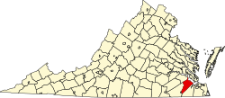
Location within the U.S. state of Virginia
Virginia in United States.svg
Virginia's location within the U.S.
Coordinates: 36°55′N76°43′W / 36.91°N 76.71°W / 36.91; -76.71
CountryFlag of the United States.svg United States
StateFlag of Virginia.svg  Virginia
Founded1634
Named for Isle of Wight
Seat Isle of Wight
Largest town Smithfield
Area
  Total363 sq mi (940 km2)
  Land316 sq mi (820 km2)
  Water47 sq mi (120 km2)  13.0%
Population
 (2020)
  Total38,606
  Density110/sq mi (41/km2)
Time zone UTC−5 (Eastern)
  Summer (DST) UTC−4 (EDT)
Congressional district 2nd
Website www.co.isle-of-wight.va.us

Isle of Wight County is a county located in the Hampton Roads region of the U.S. state of Virginia. It was named after the Isle of Wight, England, south of the Solent, from where many of its early colonists had come. [3] As of the 2020 census, the population was 38,606. [4] Its county seat is Isle of Wight, an unincorporated community. [5]

Contents

Isle of Wight County is located in the Virginia Beach-Norfolk-Newport News, VA-NC Metropolitan Statistical Area. Its northeastern boundary is on the coast of Hampton Roads waterway.

Isle of Wight County features two incorporated towns, Smithfield and Windsor. The first courthouse for the county was built in Smithfield in 1750. The original courthouse and its associated tavern (The Smithfield Inn) are still standing.

As the county population developed, leaders thought they needed a county seat near the center of the area. They built a new courthouse near the center of the county in 1800. The 1800 brick courthouse and its associated tavern (Boykin's Tavern) are still standing, as are the 1822 clerk's offices nearby. Some additions have been made. The 1800 courthouse is used daily, serving as the government chambers for the Board of Supervisors, as well as the meeting hall for the school board. The chambers are sometimes used as a court for civil trials if the new courthouse is fully in use. The new courthouse opened in 2010; it is across the street from the sheriff's office and county offices complex.

History

During the 17th century, shortly after establishment of the settlement at Jamestown in 1607, English settlers explored and began settling the areas adjacent to the large Hampton Roads waterway. Captain John Smith in 1608 crossed the James River and obtained fourteen bushels of corn from the Native American inhabitants, the Warrosquyoack or Warraskoyak. They were a tribe of the Powhatan Confederacy, who had three villages in the area of modern Smithfield. English colonists drove the Warraskoyak from their villages in 1622 and 1627, as part of their reprisals for the Great Massacre of 1622, in which the Native Americans had decimated English settlements, hoping to drive them out of their territory.

The first English plantations along the south shore within present-day Isle of Wight were established by Puritan colonists, beginning with that of Christopher Lawne in May 1618, and Edward Bennett (colonist) in 1621. Several members of the Puritan Bennett family also settled there, including Edward's nephew, Richard Bennett. He led the Puritans to neighboring Nansemond in 1635, and later was appointed as governor of the Virginia Colony.

By 1634, the entire Colony consisted of eight shires or counties with a total population of approximately 5,000 inhabitants. Warrosquyoake Shire was renamed in 1637 as Isle of Wight County, after the island off the south coast of England. The original name had come derived from the Native Americans of the area; it went through transliteration and Anglicisation, eventually becoming known as "Warwicke Squeake".

On October 20, 1673, the "Grand Assembly" at Jamestown authorized both Isle of Wight County and Lower Norfolk County to construct a fort. [6]

St. Luke's Church, built in the 17th century, is Virginia's oldest church building. [7] In the late 20th century, it was designated as a National Historic Landmark in recognition of its significance. Many landmark and contributing structures on the National Register are located in Smithfield including the Wentworth-Grinnan House.

In 1732 a considerable portion of the northwestern part of the original shire was added to Brunswick County, and in 1748 the entire county of Southampton was carved out of it.

During the American Civil War, Company F of the 61st Virginia Infantry Regiment of the Confederate Army was called the "Isle of Wight Avengers."

Geography

According to the U.S. Census Bureau, the county has a total area of 363 square miles (940 km2), of which 316 square miles (820 km2) is land and 47 square miles (120 km2) (13.0%) is water. [8]

The county is bounded by the James River on the north and the Blackwater River to the south. The land is generally low-lying, with many swamps and pocosins.

Adjacent counties and independent cities

Major highways

Demographics

Historical population
CensusPop.Note
1790 9,028
1800 9,3423.5%
1810 9,186−1.7%
1820 10,13910.4%
1830 10,5173.7%
1840 9,972−5.2%
1850 9,353−6.2%
1860 9,9776.7%
1870 8,320−16.6%
1880 10,57227.1%
1890 11,3137.0%
1900 13,10215.8%
1910 14,92913.9%
1920 14,433−3.3%
1930 13,409−7.1%
1940 13,381−0.2%
1950 14,90611.4%
1960 17,16415.1%
1970 18,2856.5%
1980 21,60318.1%
1990 25,50318.1%
2000 29,72816.6%
2010 35,27018.6%
2020 38,6069.5%
U.S. Decennial Census [9]
1790-1960 [10] 1900-1990 [11]
1990-2000 [12] 2010-2020 [13]

2020 census

Isle of Wight County, Virginia – Racial and ethnic composition
Note: the US Census treats Hispanic/Latino as an ethnic category. This table excludes Latinos from the racial categories and assigns them to a separate category. Hispanics/Latinos may be of any race.
Race / Ethnicity (NH = Non-Hispanic)Pop 2010 [14] Pop 2020 [13] % 2010% 2020
White alone (NH)24,96926,41070.79%68.41%
Black or African American alone (NH)8,6568,57924.54%22.22%
Native American or Alaska Native alone (NH)1041390.29%0.36%
Asian alone (NH)2753910.78%1.01%
Pacific Islander alone (NH)13310.04%0.08%
Some Other Race alone (NH)542020.15%0.52%
Mixed Race or Multi-Racial (NH)5411,6551.53%4.29%
Hispanic or Latino (any race)6581,1991.87%3.11%
Total35,27038,606100.00%100.00%

2010 Census

As of the census [15] of 2010, there were 35,270 people, 11,319 households, and 8,670 families residing in the county. The population density was 94 inhabitants per square mile (36/km2). There were 12,066 housing units at an average density of 38 units per square mile (15 units/km2). The racial makeup of the county was 71.8% White, 24.7% Black or African American, 0.4% Native American, 0.8% Asian, 0.0% Pacific Islander, 0.5% from other races, and 1.8% from two or more races. 1.9% of the population were Hispanic or Latino of any race.

There were 11,319 households, out of which 34.00% had children under the age of 18 living with them, 60.40% were married couples living together, 12.20% had a female householder with no husband present, and 23.40% were non-families. 20.00% of all households were made up of individuals, and 8.60% had someone living alone who was 65 years of age or older. The average household size was 2.61 and the average family size was 2.99.

In the county, the population was spread out, with 25.40% under the age of 18, 6.60% from 18 to 24, 29.60% from 25 to 44, 26.20% from 45 to 64, and 12.20% who were 65 years of age or older. The median age was 39 years. For every 100 females there were 95.70 males. For every 100 females aged 18 and over, there were 91.70 males.

The median income for a household in the county was $45,387, and the median income for a family was $52,597. Males had a median income of $37,853 versus $22,990 for females. The per capita income for the county was $20,235. About 6.60% of families and 8.30% of the population were below the poverty line, including 8.80% of those under age 18 and 11.90% of those age 65 or over.

Government

Board of Supervisors

Constitutional officers

State and federal elected officials

House of Delegates:

Senate:

U.S. House of Representatives:

United States presidential election results for Isle of Wight County, Virginia [16]
Year Republican Democratic Third party
No.%No.%No.%
2020 13,70758.44%9,39940.07%3501.49%
2016 12,20457.91%7,88137.40%9904.70%
2012 11,80256.67%8,76142.07%2641.27%
2008 11,25856.30%8,57342.87%1660.83%
2004 9,92962.56%5,87136.99%710.45%
2000 7,58758.59%5,16239.86%2011.55%
1996 5,41647.64%4,95243.56%1,0018.80%
1992 5,37047.16%4,38038.46%1,63714.38%
1988 5,77960.07%3,74738.95%950.99%
1984 5,66460.18%3,65038.78%981.04%
1980 3,52645.30%3,95150.76%3073.94%
1976 2,71838.78%4,14559.14%1462.08%
1972 3,55559.27%2,30538.43%1382.30%
1968 1,31223.28%1,97735.08%2,34641.63%
1964 1,73739.49%2,65660.38%60.14%
1960 1,14135.91%2,02063.58%160.50%
1956 1,29847.08%1,32448.02%1354.90%
1952 99644.52%1,22754.85%140.63%
1948 44227.78%1,06466.88%855.34%
1944 43026.74%1,17873.26%00.00%
1940 20815.45%1,13884.55%00.00%
1936 20716.76%1,02583.00%30.24%
1932 28422.27%98277.02%90.71%
1928 55551.10%53148.90%00.00%
1924 19022.97%63176.30%60.73%
1920 24524.38%75975.52%10.10%
1916 14017.07%67982.80%10.12%
1912 758.48%70880.09%10111.43%

Public services

Blackwater Regional Library is the regional library system that provides services to the citizens of Isle of Wight.

Communities

Towns

Census-designated places

Other unincorporated communities

See also

Related Research Articles

<span class="mw-page-title-main">Southampton County, Virginia</span> County in Virginia, United States

Southampton County is a county located on the southern border of the Commonwealth of Virginia. North Carolina is to the south. As of the 2020 census, the population was 17,996. Its county seat is Courtland.

<span class="mw-page-title-main">Prince George County, Virginia</span> County in Virginia, United States

Prince George County is a county located in the Commonwealth of Virginia. As of the 2020 census, the population was 43,010. Its county seat is Prince George.

<span class="mw-page-title-main">Powhatan County, Virginia</span> County in Virginia, United States

Powhatan County is a county located in the Commonwealth of Virginia. As of the 2020 census, the population was 30,033. Its county seat is Powhatan.

<span class="mw-page-title-main">Lancaster County, Virginia</span> County in Virginia, United States

Lancaster County is a county located on the Northern Neck in the Commonwealth of Virginia. As of the 2020 census, the population sits at 10,919. Its county seat is Lancaster.

<span class="mw-page-title-main">Hanover County, Virginia</span> County in Virginia, United States

Hanover County is a county in the Commonwealth of Virginia. As of the 2020 census, the population was 109,979. Its county seat is Hanover Courthouse.

<span class="mw-page-title-main">Halifax County, Virginia</span> County in Virginia, United States

Halifax County is a county located in the Commonwealth of Virginia. As of the 2020 census, the population was 34,022. Its county seat is Halifax.

<span class="mw-page-title-main">Cumberland County, Virginia</span> County in Virginia, United States

Cumberland County is a county located in the Commonwealth of Virginia, United States. As of the 2020 census, the population was 9,675. Its county seat is Cumberland.

<span class="mw-page-title-main">Craig County, Virginia</span> County in Virginia, United States

Craig County is a county located in the Commonwealth of Virginia. As of the 2020 census, the population was 4,892. Its county seat is New Castle.

<span class="mw-page-title-main">Clarke County, Virginia</span> County in Virginia, United States

Clarke County is a county in the Commonwealth of Virginia. As of the 2020 census, the population was 14,783. Its county seat is Berryville. Clarke County is included in the Washington-Arlington-Alexandria, DC-VA-MD-WV Metropolitan Statistical Area.

<span class="mw-page-title-main">Brunswick County, Virginia</span> County in Virginia, United States

Brunswick County is a United States county located on the southern border of the Commonwealth of Virginia. This rural county is known as one of the claimants to be the namesake of Brunswick stew. Brunswick County was created in 1720 from parts of Prince George, Surry and Isle of Wight counties. The county was named for the former Duchy of Brunswick-Lunenburg, the region from which the British monarchs of the House of Hanover originated. As of the 2020 census, the county population was 15,849. The Brunswick county seat is Lawrenceville.

<span class="mw-page-title-main">Page County, Iowa</span> County in Iowa, United States

Page County is a county located in the U.S. state of Iowa. As of the 2020 census, the population was 15,211. The county seat is Clarinda. The county is named in honor of Captain John Page of the 4th U.S. Infantry, who was mortally wounded in the Battle of Palo Alto.

<span class="mw-page-title-main">Charlotte Court House, Virginia</span> Town in Virginia, United States

Charlotte Court House is a town in and the county seat of Charlotte County, Virginia, United States. The population was 756 at the 2020 census.

<span class="mw-page-title-main">Rushmere, Virginia</span> Census-designated place in Virginia, United States

Rushmere is a census-designated place (CDP) in Isle of Wight County, Virginia, United States. The population was 1,018 at the 2010 census.

<span class="mw-page-title-main">Smithfield, Virginia</span> Town in Virginia, United States

Smithfield is a town in Isle of Wight County, in the South Hampton Roads subregion of the Hampton Roads region of Virginia in the United States. The population was 8,533 at the 2020 census.

<span class="mw-page-title-main">Windsor, Virginia</span> Town in Virginia, United States

Windsor is an incorporated town in Isle of Wight County in the Hampton Roads region of southeastern Virginia in the United States. It is located near the crossroads of U.S. Route 460 and U.S. Route 258. The population was 2,626 at the 2010 census, up from 916 at the 2000 census.

<span class="mw-page-title-main">Eastville, Virginia</span> Town in Virginia, United States

Eastville is a town in Northampton County, Virginia, United States. The population was 203 at the 2000 census. It is the county seat of Northampton County. The Northampton County Courthouse Historic District is part of the Eastville Historic District at the county seat.

<span class="mw-page-title-main">Sussex County, Virginia</span> County in Virginia, United States

Sussex County is a rural county located in the southeast of the Commonwealth of Virginia. As of the 2020 census, the population was 10,829. Its county seat is Sussex. It was formed in 1754 from Surry County. The county is named after the county of Sussex, England.

<span class="mw-page-title-main">Surry County, Virginia</span> County in Virginia, United States

Surry County is a county in the Commonwealth of Virginia. As of the 2020 census, the population was 6,561.

<span class="mw-page-title-main">Dranesville, Virginia</span> Census-designated place in Virginia, United States

Dranesville is a census-designated place (CDP) in Fairfax County, Virginia, United States. Dranesville is located on the Leesburg Pike at its intersection with Georgetown Pike. The U.S. Census Bureau defines Dranesville as a census-designated place (CDP) with a population of 11,921 as of 2010. At the 2020 Census the population was 11,785.

<span class="mw-page-title-main">King William County, Virginia</span> County in Virginia, United States

King William County is a county located in the U.S. state of Virginia. As of the 2020 census, the population was 17,810. Its county seat is King William.

References

  1. Fisher, Marc (May 30, 2021). "The Confederacy's final resting place". Washington Post .
  2. Fisher, Marc (May 30, 2021). "The Confederacy's final resting place". Washington Post .
  3. Gannett, Henry (1905). The Origin of Certain Place Names in the United States. Govt. Print. Off. pp.  167.
  4. "Isle of Wight County, Virginia". United States Census Bureau . Retrieved January 30, 2022.
  5. "Find a County". National Association of Counties. Archived from the original on May 31, 2011. Retrieved June 7, 2011.
  6. "America and West Indies: March 1676." Calendar of State Papers Colonial, America and West Indies: Volume 9, 1675-1676 and Addenda 1574-1674. Ed. W Noel Sainsbury. London: Her Majesty's Stationery Office, 1893. 355-365. British History Online Retrieved 5 June 2019.
  7. "Historic St. Luke's Church". Archived from the original on May 5, 2007. Retrieved May 28, 2007., Historic St. Luke's website
  8. "US Gazetteer files: 2010, 2000, and 1990". United States Census Bureau. February 12, 2011. Retrieved April 23, 2011.
  9. "Census of Population and Housing from 1790". US Census Bureau . Retrieved January 24, 2022.
  10. "Historical Census Browser". University of Virginia Library. Archived from the original on August 11, 2012. Retrieved January 3, 2014.
  11. "Population of Counties by Decennial Census: 1900 to 1990". United States Census Bureau. Archived from the original on December 15, 2013. Retrieved January 3, 2014.
  12. "Census 2000 PHC-T-4. Ranking Tables for Counties: 1990 and 2000" (PDF). United States Census Bureau. Archived (PDF) from the original on December 18, 2014. Retrieved January 3, 2014.
  13. 1 2 "P2 Hispanic or Latino, and Not Hispanic or Latino by Race – 2020: DEC Redistricting Data (PL 94-171) - Isle of Wight County, Virginia". United States Census Bureau .
  14. "P2 Hispanic or Latino, and Not Hispanic or Latino by Race – 2010: DEC Redistricting Data (PL 94-171) - Isle of Wight County, Virginia". United States Census Bureau .
  15. "U.S. Census website". United States Census Bureau . Retrieved May 14, 2011.
  16. Leip, David. "Dave Leip's Atlas of U.S. Presidential Elections". uselectionatlas.org. Archived from the original on March 23, 2018.

36°55′N76°43′W / 36.91°N 76.71°W / 36.91; -76.71