Camptown, Virginia | |
|---|---|
 Camptown  Camptown | |
| Coordinates: 36°40′58″N76°54′41″W / 36.68278°N 76.91139°W | |
| Country | United States |
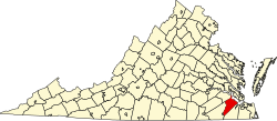
| State | Virginia |
| County | Isle of Wight |
| Area | |
• Total | 6.3 sq mi (16.4 km2) |
| • Land | 6.1 sq mi (15.7 km2) |
| • Water | 0.27 sq mi (0.7 km2) |
| Elevation | 29 ft (8.8 m) |
| Population (2010) | |
• Total | 766 |
| • Density | 126/sq mi (48.7/km2) |
| Time zone | UTC−5 (Eastern (EST)) |
| • Summer (DST) | UTC−4 (EDT) |
| ZIP code | 23851 |
| FIPS code | 51-12590 |
| GNIS feature ID | 2584821 |
Camptown is a census-designated place in Isle of Wight County, Virginia, United States, lying just east of Franklin. The population as of the 2010 census was 766. [1] The International Paper mill (formerly Union Camp, now closed) is here along with a Black community known as Camptown.