Southwest Virginia

Last updated
Southwest Virginia at its greatest geographical definition Southwest- Location.svg
Southwest Virginia at its greatest geographical definition

Southwest Virginia, often abbreviated as SWVA, is a mountainous region of Virginia in the westernmost part of the commonwealth. Located within the broader region of western Virginia, Southwest Virginia has been defined alternatively as all Virginia counties on the Appalachian Plateau, all Virginia counties west of the Eastern Continental Divide, or at its greatest expanse, as far east as Blacksburg and Roanoke. Another geographic categorization of the region places it as those counties within the Tennessee River watershed. Regardless of how borders are drawn, Southwest Virginia differs from the rest of the commonwealth in that its culture is more closely associated with Appalachia than the other regions of Virginia. Historically, the region has been and remains a rural area, but in the 20th century, coal mining became an important part of its economy. With the decline in the number of coal jobs and the decline of tobacco as a cash crop, Southwest Virginia is increasingly turning to tourism as a source of economic development. Collectively, Southwest Virginia's craft, music, agritourism and outdoor recreation are referred to as the region's "creative economy." [1]

Contents

Counties that have been included in the definition of Southwest Virginia include: Alleghany County, Bedford County, Bland County, Botetourt County, Buchanan County, Carroll County, Craig County, Dickenson County, Floyd County, Franklin County, Giles County, Grayson County, Henry County, Lee County, Montgomery County, Patrick County, Pulaski County, Roanoke County, Rockbridge County, Russell County, Scott County, Smyth County, Tazewell County, Washington County, Wise County, and Wythe County.

Unlike other states in the U.S., Virginia draws a sharp distinction between cities and other incorporated communities, all of which are designated as towns. Under state law, all municipalities incorporated as cities are independent of any county. By contrast, places incorporated as towns are included within counties. Independent cities in Southwest Virginia include Bristol, Buena Vista, Covington, Galax, Lexington, Martinsville, Norton, Radford, Roanoke, and Salem.

Culture

The culture of Southwest Virginia is more consistent with the wider Appalachian region than with the rest of the state of Virginia. This is due in large part to the geographical diversity of the state, with the Appalachian and Blue Ridge mountains dominating the region.

History

Southwest Virginia was among the last parts of the state to be settled by Europeans, in a flow of migrations that consisted mainly of English, German, and Scots-Irish and Irish immigrants. A major route of migration to the region was the Great Wagon Road through the Great Appalachian Valley. At present-day Roanoke there was an important fork in the wagon road, with one branch passing through the Blue Ridge and into the Piedmont region, and the other branch, called the Wilderness Road, continuing southwest to Tennessee and Kentucky. Much of the area was protected by a series of forts constructed around the time of Lord Dunmore's War, some of which later became the seats of future counties.

The first major industry in Southwest Virginia which laid the foundation for the regionally important town of Abingdon was salt. In Saltville (a small town now located on the Smyth-Washington county line), salt was (and still is) produced by using water to extract salt from the ground.

Many of the present day counties were formed from larger counties which were broken up as the populations in the region continued to grow. Southwest Virginia is also the result of parts of Virginia which broke off or revolted, such as Kentucky and West Virginia. During the American Revolution, residents from southwest Virginia were among those who participated in the Battle of King's Mountain, which occurred in South Carolina. [2]

In the Civil War, Southwest Virginia was deeply divided between sentiment for the Union and the Confederacy and was subject to guerilla warfare. The only major battles to occur in the area were the Smyth County Battle of Saltville and of Marion, while many skirmishes occurred throughout much of the region. In 1864, Union General George Stoneman led a devastating raid into Southwest Virginia, destroying the saltworks in Saltville and burning all that he thought useful to the Confederates. At the time, the saltworks were considered a very important strategic target. [3]

In the late 1800s and early 1900s, extractive industries became important in the region, especially the cutting of timber and coal mining. The coalfield region has experienced a significant loss of population over the last generation, resulting in shrinking political representation and a variety of local issues, including the need to consolidate schools.

Manufacturing, which did well during part of the 20th century, has also declined in Southwest Virginia despite local officials' efforts to recruit new industry. Tobacco has declined since the buyout of the federal quota program as well. Since the early 2000s, natural gas extraction has grown into an important industry, particularly in the coalfield region. Throughout Southwest Virginia, tourism has also begun to take off as an important industry.

Geography

The Virginia highlands in Southwest Virginia Whitetop.jpg
The Virginia highlands in Southwest Virginia

The Appalachian Mountains have the most direct impact upon the geography of Southwest Virginia and are often credited for isolating its residents from the rest of the commonwealth. Southwest Virginia falls into the ridge and valley and the Blue Ridge portions of the range. Within the mountains, coal fields have been one of the sources of the significant economic booms in the region. The major river of the region is the New River, credited as the oldest river in North America.

Flooding has been epidemic in the more mountainous areas, with major floods occurring about once every other decade with great loss of life and property. Such disasters have encouraged local precautions to prevent future problems, such as the Grundy Flood Control and Redevelopment Project, in Grundy, Virginia, a multimillion-dollar effort to protect the town from future flooding. [4] This federally funded project moved an entire town up off of the river bank and, on a site blasted out of a mountainside.

Cities and Towns

Independent Cities in Southwest Virginia

Towns in Southwest Virginia

Political representation

Like the rest of the commonwealth, Southwest Virginia is represented by Senators Mark Warner and Tim Kaine in the United States Senate. In the House of Representatives, by the narrowest and almost to the largest definition of Southwest Virginia, representation falls largely under Representative Morgan Griffith of the 9th Congressional District. In 2010, Griffith defeated long-time representative Rick Boucher. Boucher had previously been a long term representative of the region in Congress, spending more than twenty-four years in office as a Democrat. His predecessor was William C. Wampler, a Republican, who had served a nearly equally long term of over eighteen years prior to his political defeat by Boucher. Republican Ben Cline of Rockbridge County represents the 6th Congressional District which also covers Lynchburg and much of the Shenandoah Valley. Republican Bob Goodlatte represented the 6th district for 26 years before retiring in 2019. Since most of Southwest Virginia has experienced little to no population growth in recent decades, the 9th district has begun to encroach into areas previously in the 5th and 6th districts.

Southwest Virginia's delegation to the Virginia General Assembly is known for sticking together, regardless of party. Democrats and Republicans from Southwest Virginia have a reputation for putting region above party, presenting a united front to ensure that money and resources make it to their end of the state. It is often remarked that the region is closer to several other states' capitals than it is to the Virginia state capital of Richmond [5] —and thus, they need to work together if they hope to be heard. As a largely rural and relatively poor area of the state, Southwest Virginia is often at odds politically with wealthier, more urban parts of Virginia, which naturally have different priorities. Even so, several leaders from the region have gone on to have significant statewide or national influence.

Southwest Virginia's current state senators include Todd Pillion (R-Abingdon), John Edwards (D-Roanoke), and formerly Ben Chafin (R-Lebanon), until his death in January 2020. Its current state delegates include Terry Kilgore (R-Gate City), Israel O'Quinn (R-Bristol), Will Morefield (R-Tazewell), Will Wampler (R-Abingdon), and Jason Ballard (R-Pearisburg).[ citation needed ]

Education

Southwest Virginia is home to several institutions of higher education, the largest of which is Virginia Polytechnic Institute and State University (better known as "Virginia Tech"), in Blacksburg. Virginia Tech is the largest research university in the state as well as the largest employer in Montgomery County.

Emory and Henry College is a highly respected private college near Abingdon and is recognized for its strong element of community service. In 2014 Emory and Henry College School of Health Sciences (graduate school campus) was established and is located in Marion.

There are two medical schools in Blacksburg, and efforts are underway to develop a third in Abingdon. Professional schools—including schools of law and pharmacy—have been developed in recent years in Buchanan County, which is located in Southwest Virginia's coalfield region. There is also an effort within the region to help make higher education more accessible to students graduating from high school, particularly through partnerships between community colleges and other educational institutions.

List of colleges and universities

Appalachian Regional Commission

Map showing 2001-2003 ARC economic designations for counties and cities in "Appalachian" Virginia. Virginia-counties-arc-2003.png
Map showing 2001-2003 ARC economic designations for counties and cities in "Appalachian" Virginia.

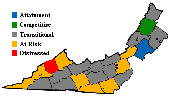
The Appalachian Regional Commission was formed in 1965 to aid economic development in the Appalachian region, which was lagging far behind the rest of the nation on most economic indicators. The Appalachian region currently defined by the Commission includes 420 counties in 13 states, including the westernmost counties and cities in Virginia. The Commission gives each county one of five possible economic designations distressed, at-risk, transitional, competitive, or attainment with "distressed" counties being the most economically endangered and "attainment" counties being the most economically prosperous. These designations are based primarily on three indicators three-year average unemployment rate, market income per capita, and poverty rate. For data collection purposes, independent cities within the designated region are grouped with an adjacent county. [6]

In 2003, Appalachian Virginia which included most of Southwestern Virginia had a three-year average unemployment rate of 5.7%, compared with 3.8% statewide and 5.5% nationwide. In 2002, Appalachian Virginia had a per capita market income of $16,901, compared with $29,279 statewide and $26,420 nationwide. In 2000, Appalachian Virginia had a poverty rate of 15.7%, compared to 9.6% statewide and 12.4% nationwide. Only one Virginia county Dickenson was designated "Distressed," while eight Buchanan, Carroll (includes Galax), Craig, Grayson, Lee, Montgomery (includes Radford), Smyth, and Wise (includes Norton) were designated "at-risk." Botetourt County was the only county given the "attainment" designation, and Bath was the only county designated "competitive." Most Appalachian Virginia counties were designated "transitional," meaning they lagged behind the national average on one of the three key indicators. Montgomery County had Appalachian Virginia's highest poverty rating, with 24.5% of its residents living below the poverty line. Botetourt had Appalachian Virginia's highest per capita income ($27,835) and lowest unemployment rate (2.7%). [6]

See also

Related Research Articles

<span class="mw-page-title-main">Washington County, Virginia</span> County in Virginia, United States

Washington County is a county located in the Commonwealth of Virginia. As of the 2020 census, the population was 53,935. Its county seat is Abingdon.

<span class="mw-page-title-main">Galax, Virginia</span> Independent city in Virginia, United States

Galax is an independent city in the southwestern part of the Commonwealth of Virginia. As of the 2020 census, the population was 6,720.

<span class="mw-page-title-main">Buchanan County, Virginia</span> County in Virginia, United States

Buchanan County is a United States county in far western Virginia, the only county in the state to border both West Virginia and Kentucky. The county is part of the Southwest Virginia region and lies in the rugged Appalachian Plateau portion of the Appalachian Mountains. Its county seat is Grundy.

<span class="mw-page-title-main">Grundy, Virginia</span> Town in Virginia, United States

Grundy is a town in Buchanan County, Virginia, United States, an area located within the Appalachian Mountains region. It is the county seat of Buchanan County. The town is home to the Appalachian School of Law. The population was 875 as of the 2020 census.

<span class="mw-page-title-main">New River Valley</span>

Virginia's New River Valley region, colloquially named, is a four-county area along the New River in Southwest Virginia in the United States, including such major features as Claytor Lake, part of the Jefferson National Forest, the city of Radford, the town of Blacksburg, and the river itself, including the Pulaski terminus of the New River Trail State Park.

<span class="mw-page-title-main">U.S. Route 460</span> Highway in the United States

U.S. Route 460 (US 460) is an auxiliary route of U.S. Route 60. It currently runs for 655 miles (1,054 km) from Norfolk, Virginia, at its parent route U.S. Route 60 at Ocean View to Frankfort, Kentucky, intersecting its parent route once again. It passes through the states of Virginia, West Virginia, and Kentucky. It goes through the cities and towns of Norfolk, Portsmouth, Suffolk, Petersburg, Farmville, Lynchburg, Roanoke, Christiansburg, Blacksburg, Tazewell, and Grundy, in Virginia; Princeton and Bluefield in West Virginia; and Pikeville, Georgetown, and Frankfort in Kentucky.

<span class="mw-page-title-main">United States District Court for the Western District of Virginia</span> United States federal district court in Virginia

The United States District Court for the Western District of Virginia is a United States district court.

<span class="mw-page-title-main">Area codes 540 and 826</span> Area code for northwestern Virginia, United States

Area codes 540 and 826 are telephone area codes in the North American Numbering Plan (NANP) for the north-western region of the U.S. State of Virginia, including the Shenandoah Valley, the Roanoke metropolitan area, the northern and eastern parts in Virginia of the New River Valley, and the outermost parts of the Washington metropolitan area. The Virginia State Corporation Commission authorized the addition of 826 to the numbering plan area for implementation in May 2022.

The Roanoke Valley in southwest Virginia is an area adjacent to and including the Roanoke River between the Blue Ridge Mountains to the east and the Appalachian Plateau to the west. The valley includes much of Roanoke County, as well as the two independent cities of Roanoke and Salem.

Carilion Clinic is a Roanoke, Virginia-based non-profit integrated health care organization. Carilion owns and operates seven hospitals in the western part of Virginia, such as Radford University Carilion, and a joint venture medical school and research institute with Virginia Tech. The system consists of hospitals, primary and specialty physician practices, pharmacies, health clubs and other complementary services. Carilion has more than 13,200 employees with 737 physicians covering more than 70 specialties at 225 practice sites, making it the largest employer in the Roanoke Valley.

<span class="mw-page-title-main">U.S. Route 11 in Virginia</span> Highway in Virginia

U.S. Route 11 (US 11) is a north–south United States Numbered Highway in western Virginia. At 339 miles (546 km), it is the second longest numbered route and longest primarily north–south route in the state. It enters the state from Tennessee as the divided routes US 11E and US 11W at Bristol, roughly follows the West Virginia border through the Blue Ridge Mountains and Shenandoah Valley, and enters the Eastern Panhandle of West Virginia from Frederick County. Most of the route closely parallels I-81. From south to north, US 11 serves the cities and towns of Bristol, Abingdon, Wytheville, Pulaski, Radford, Christiansburg, Roanoke, Lexington, Staunton, Harrisonburg, Strasburg, and Winchester. As one of the original U.S. Highways, it was first designated through Virginia in 1926 and has largely followed the same route since. Prior to the construction of the Interstate Highway System, it was the primary long-distance route for traversing the western part of the state. Much of it roughly follows the Great Wagon Road, a colonial-era road that followed the Appalachian Mountains from Georgia to Pennsylvania.

<span class="mw-page-title-main">Interstate 81 in Virginia</span> Section of Interstate Highway in Virginia, United States

Interstate 81 (I-81) is an 855.02-mile-long (1,376.02 km) Interstate Highway. In the US state of Virginia, I-81 runs for 324.92 miles (522.91 km), making the portion in Virginia longer than any other state's portion of the route. It is also the longest Interstate Highway within the borders of Virginia. It stretches from the Tennessee state line near Bristol to the West Virginia state line near Winchester. It enters Virginia from Bristol, Tennessee, and leaves Virginia into Berkeley County, West Virginia. The route passes through the cities of Bristol, Roanoke, Lexington, Staunton, and Harrisonburg.

The Roanoke Region is the area of the Commonwealth of Virginia surrounding the city of Roanoke. Its usage may refer to the metropolitan statistical area or the Roanoke Valley, but it sometimes includes areas in the Allegheny Mountains and New River Valley which includes Alleghany County, Montgomery County, Covington, Clifton Forge, Blacksburg, Christiansburg, and Radford. Bedford County and Floyd County are sometimes included as part of the region.

<span class="mw-page-title-main">2000 United States presidential election in Virginia</span> Election in Virginia

The 2000 United States presidential election in Virginia took place on November 7, 2000, and was part of the 2000 United States presidential election. Voters chose 13 representatives, or electors to the Electoral College, who voted for president and vice president.

<span class="mw-page-title-main">2002 United States Senate election in Virginia</span> Election

The 2002 United States Senate election in Virginia was held on November 5, 2002. Incumbent Senator John Warner won re-election to a fifth term, making him one of only three Virginia U.S. Senators to serve five or more terms. Democrats did not field a candidate against Warner, and he won every single county and city in the state with at least 60% of the vote. As of 2024, this was the last time Republicans won a U.S. Senate election in Virginia.

The Southwest Virginia Cultural Center and Marketplace (formerly Heartwood) is a visitor center, music venue, artisan marketplace, and community space located in Southwest Virginia in Abingdon, Virginia and is the gateway to regional craft, music, food outdoors, and local culture.

The Crooked Road is a heritage trail in Southwestern Virginia, that explores the musical history of the region along Southwest Virginia's Blue Ridge and Cumberland Mountains. The Crooked Road winds through almost 300 miles of scenic terrain in southwest Virginia, including 19 counties, four cities, and 54 towns.

<span class="mw-page-title-main">Ballad Health</span> Healthcare company based in Tennessee, US

Ballad Health is a chain of hospitals headquartered in Johnson City, Tennessee. It includes facilities in Tennessee, and Virginia. Some of its locations are also Urgent care centers and Primary care locations. They also operate a blood bank named Marsh Regional Blood Center.

References

  1. Mayer, Holzheimer. "Virginia's Creative Economy" (PDF). Virginia Tech.
  2. "NCpedia | NCpedia". www.ncpedia.org. Retrieved 2022-03-14.
  3. "Saltville during the Civil War – Encyclopedia Virginia" . Retrieved 2022-03-14.
  4. Article on Representative Rich Boucher's website on Grundy flood control
  5. "Editorial: Southwest Virginia is further away from Richmond than you think". Roanoke Times . Retrieved 2021-02-15.
  6. 1 2 Appalachian Regional Commission Online Resource Center Archived 2010-01-11 at the Wayback Machine . Retrieved: 15 May 2009.