New Castle, Virginia | |
|---|---|
 Town hall | |
 Location of New Castle, Virginia | |
| Coordinates: 37°30′3″N80°6′39″W / 37.50083°N 80.11083°W | |
| Country | United States |
| State | Virginia |
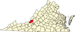
| County | Craig |
| Area | |
• Total | 0.17 sq mi (0.4 km2) |
| • Land | 0.17 sq mi (0.4 km2) |
| • Water | 0.00 sq mi (0.0 km2) |
| Elevation | 1,352 ft (412 m) |
| Population (2020) | |
• Total | 125 |
| • Density | 927.27/sq mi (358.02/km2) |
| Time zone | UTC-5 (Eastern (EST)) |
| • Summer (DST) | UTC-4 (EDT) |
| ZIP code | 24127 |
| Area code | 540 |
| FIPS code | 51-55592 [2] |
| GNIS feature ID | 1498522 [3] |
New Castle (historically spelled as one word; "Newcastle") is the only town in Craig County, Virginia, United States. The population was 125 at the 2020 census. [4] It is the county seat of Craig County. [5]
Contents
The junctions of State Route 311 and State Route 42 and State Route 311 and State Route 615 are in New Castle.
New Castle is part of the Roanoke metropolitan area.