Charlotte Court House, Virginia

Last updated

Charlotte Court House, Virginia
Charlotte Courthouse HD - center of town.jpg
Central Charlotte Court House
Seal of Charlotte Court House, Virginia.png
VAMap-doton-CharlotteCourtHouse.PNG
Location of Charlotte Court House, Virginia
Coordinates: 37°3′25″N78°38′3″W / 37.05694°N 78.63417°W / 37.05694; -78.63417
CountryUnited States
State Virginia
County Charlotte
Government
  TypeMayor/Council
Area
[1]
  Total3.96 sq mi (10.3 km2)
  Land3.96 sq mi (10.3 km2)
  Water0.00 sq mi (0.0 km2)
Elevation
620 ft (190 m)
Population
 (2020)
  Total756 [2]
  Density190.9/sq mi (73.7/km2)
Time zone UTC−5 (Eastern (EST))
  Summer (DST) UTC−4 (EDT)
ZIP code
23923
Area code 434
FIPS code 51-14952 [3]
GNIS feature ID1498462 [4]
Website www.towncch.com

Charlotte Court House is a town in and the county seat of Charlotte County, Virginia, United States. [5] The population was 756 at the 2020 census.

Contents

Geography

The town is located near the center of Charlotte County. Virginia State Route 40 passes through the town center, leading west 19 miles (31 km) to Brookneal and east 9 miles (14 km) to Keysville. Virginia State Route 47 crosses Route 40 in the center of town, leading north 17 miles (27 km) to Pamplin and south 13 miles (21 km) to U.S. Route 15.

According to the United States Census Bureau, Charlotte Court House has a total area of 4.0 square miles (10.3 km2), all of it land.

History

Patrick Henry gave his last political speech in opposition to the Virginia and Kentucky Resolutions at Charlotte Courthouse in March 1799. The central courthouse area is a source of pride for those who work and live there. Many of the buildings represent architecture from the 1800s, including the Thomas Jefferson-designed courthouse building. The courthouse building was used in the filming of Sommersby , a movie about the post-war South, in the summer of 1992.

The Charlotte Court House Historic District, Charlotte County Courthouse, Greenfield, and Woodfork are listed on the National Register of Historic Places. [6]

This settlement was originally incorporated as 'The Magazine' in 1756. Its name changed to 'Daltonsburgh' in 1759, to 'Marysville' in 1836, and to 'Smithfield' in 1874. In 1901 the incorporation was changed to 'Charlotte Courthouse', and in 1989 it changed again, to its present name. [7]

Demographics

Historical population
CensusPop.Note
1900 96
1910 329242.7%
1920 318−3.3%
1930 36615.1%
1940 3999.0%
1950 397−0.5%
1960 55539.8%
1970 539−2.9%
1980 5685.4%
1990 531−6.5%
2000 404−23.9%
2010 54334.4%
2020 75639.2%
US Decennial Census [8]

2000 Census

As of the 2000 United States Census there were 404 people, 148 households, and 104 families in the town. The population density was 102.0 people per square mile (39.4/km2). There were 177 housing units at an average density of 44.7 per square mile (17.3/km2). The racial makeup of the town was 55.20% White, 43.81% African American, 0.74% from other races, and 0.25% from two or more races. Hispanic or Latino of any race were 0.99% of the population.

There were 148 households, out of which 23.0% had children under the age of 18 living with them, 54.1% were married couples living together, 13.5% had a female householder with no husband present, and 29.1% were non-families. 26.4% of all households were made up of individuals, and 18.9% had someone living alone who was 65 years of age or older. The average household size was 2.39 and the average family size was 2.90.

The town population contained 18.1% under the age of 18, 10.4% from 18 to 24, 27.0% from 25 to 44, 24.8% from 45 to 64, and 19.8% who were 65 years of age or older. The median age was 41 years. For every 100 females, there were 108.2 males. For every 100 females age 18 and over, there were 106.9 males.

The median income for a household in the town was $33,000, and the median income for a family was $42,500. Males had a median income of $26,500 versus $20,313 for females. The per capita income for the town was $26,657. About 7.8% of families and 13.8% of the population were below the poverty line, including 29.1% of those under age 18 and 3.6% of those age 65 or over.

Schools

The town contains two public schools; Randolph-Henry High School for grades 9–12, and Central Middle School for grades 6–8.

Related Research Articles

<span class="mw-page-title-main">Lewis County, West Virginia</span> County in West Virginia, United States

Lewis County is a county in the U.S. state of West Virginia. As of the 2020 census, the population was 17,033. Its county seat is Weston. The county was formed in 1816 from Harrison County.

<span class="mw-page-title-main">Appomattox County, Virginia</span> County in Virginia, United States

Appomattox County is a United States county located in the Piedmont region and near the center of the Commonwealth of Virginia. The county is part of the Lynchburg, VA Metropolitan Statistical Area, and its county seat is the town of Appomattox.

<span class="mw-page-title-main">York, South Carolina</span> City in South Carolina, United States

York is a city in and county seat of York County, South Carolina, United States. The population was approximately 6,985 at the 2000 census and up to 7,736 at the 2010 census. York is located approximately 27 miles (43 km) southwest of Charlotte, North Carolina and 13 miles (21 km) west of Rock Hill, South Carolina.

<span class="mw-page-title-main">Charlotte, Tennessee</span> Town in Tennessee, United States

Charlotte is a town in Dickson County, Tennessee, United States. The population was 1,656 at the 2020 census. It is the county seat of Dickson County. This town is part of the Nashville metropolitan area.

<span class="mw-page-title-main">Paducah, Texas</span> Town in Texas, United States

Paducah is a town in Cottle County, Texas, United States. The population was 1,186 at the 2010 census, down from 1,498 in 2000. It is the county seat of Cottle County. It is just south of the Texas Panhandle and east of the Llano Estacado.

<span class="mw-page-title-main">Rustburg, Virginia</span> Census-designated place in Virginia, United States

Rustburg is a census-designated place (CDP) in and the county seat of Campbell County, Virginia, United States. The population was 1,431 at the 2010 census. It is part of the Lynchburg Metropolitan Statistical Area.

<span class="mw-page-title-main">Drakes Branch, Virginia</span> Town in Virginia, United States

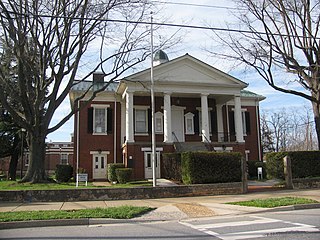
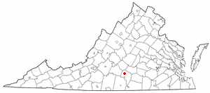
Drakes Branch is a town in Charlotte County, Virginia, United States. The population was 530 at the 2010 census.

<span class="mw-page-title-main">Keysville, Virginia</span> Town in Virginia, United States

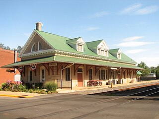
Keysville is a town in Charlotte County, Virginia, United States. The population was 832 at the 2010 census. One of two branches of Southside Virginia Community College is in Keysville. The surrounding area has tobacco and mixed farming.

<span class="mw-page-title-main">Phenix, Virginia</span> Town in Virginia, United States

Phenix is a town in Charlotte County, Virginia, United States. The population was 226 at the 2010 census.

<span class="mw-page-title-main">Pearisburg, Virginia</span> Town in Virginia, United States

Pearisburg is a town in Giles County, Virginia, and the county seat. The population was 2,786 at the time of the 2010 census. Pearisburg is part of the Blacksburg–Christiansburg Metropolitan Statistical Area.

<span class="mw-page-title-main">Stanardsville, Virginia</span> Town in Virginia, United States

Stanardsville is a town in Greene County, Virginia, United States. The population was 349 at the 2020 census, down from 367 at the 2010 census. It is the county seat of Greene County. The name is from Robert Stanard, a benefactor who donated land for public use. It is part of the Charlottesville Metropolitan Statistical Area.

<span class="mw-page-title-main">Halifax, Virginia</span> Town in Virginia, United States

Halifax is a town in Halifax County, Virginia, United States, along the Banister River. The population was 1,309 at the 2010 census. It is the county seat of Halifax County.

<span class="mw-page-title-main">Louisa, Virginia</span> Town in Virginia, United States

Louisa is a town in Louisa County, Virginia, United States. The population was 1,555 at the 2010 census. It is the county seat of Louisa County.

<span class="mw-page-title-main">Madison, Virginia</span> Town in Virginia, United States

Madison is a town in Madison County, Virginia, United States. The population was 229 at the 2010 census. It is the county seat of Madison County.

<span class="mw-page-title-main">Eastville, Virginia</span> Town in Virginia, United States

Eastville is a town in Northampton County, Virginia, United States. The population was 203 at the 2000 census. It is the county seat of Northampton County. The Northampton County Courthouse Historic District is part of the Eastville Historic District at the county seat.

<span class="mw-page-title-main">Orange, Virginia</span> Town in Virginia, United States

Orange is a town and the county seat of Orange County, Virginia, United States. The population was 5,062 at the 2020 census, representing a 7.2% increase since the 2010 census. Orange is 28 miles (45 km) northeast of Charlottesville, 88 miles (142 km) southwest of Washington, D.C., and 4 miles (6 km) east of Founding Father and fourth U.S. president James Madison's plantation of Montpelier.

<span class="mw-page-title-main">Spotsylvania Courthouse, Virginia</span> Unincorporated census-designated place in Virginia, United States

Spotsylvania Courthouse is a census-designated place (CDP) and the county seat of Spotsylvania County, Virginia, United States, located 10 miles (16 km) southwest of Fredericksburg. Recognized by the U.S. Census Bureau as a census designated place (CDP), the population was 4,239 at the 2010 census.

<span class="mw-page-title-main">Madison, West Virginia</span> City in West Virginia, United States

Madison is a city and former coal town in Boone County, West Virginia, United States. The population was 2,911 at the 2020 census. It is the county seat of Boone County.

<span class="mw-page-title-main">Capon Bridge, West Virginia</span> Town in West Virginia, United States

Capon Bridge is a town in eastern Hampshire County, West Virginia, United States, along the Northwestern Turnpike, approximately 20 miles (32 km) west of Winchester, Virginia. The population was 418 at the 2020 census. Originally known as "Glencoe", Capon Bridge was incorporated in 1902 by the Hampshire County Circuit Court. It is named because of the construction of the bridge over the Cacapon River at that place, the name of the river being derived from the Shawnee Cape-cape-de-hon, meaning "river of medicine water".

<span class="mw-page-title-main">Harrisville, West Virginia</span> Town in West Virginia, United States

Harrisville is a town in Ritchie County, West Virginia, United States. It is the county seat of Ritchie County. Harrisville is located at the junction of State Routes 31 and 16, five miles south of U.S. 50. Within the community are an elementary school, the county board of education, many businesses, three banks, a library, offices of the Ritchie Gazette and The Pennsboro News, a municipal park, and North Bend Golf Course. North Bend Lake and North Bend State Park are located just outside town limits. Municipal elections are held every two years.

References

  1. "2019 US Gazetteer Files". US Census Bureau. Retrieved August 7, 2020.
  2. "Charlotte Court House, Virginia". Data USA. Retrieved November 21, 2022.
  3. "US Census website". US Census Bureau. Retrieved January 31, 2008.
  4. "US Board on Geographic Names". United States Geological Survey. October 25, 2007. Retrieved January 31, 2008.
  5. "Find a County". National Association of Counties. Archived from the original on May 31, 2011. Retrieved June 7, 2011.
  6. "National Register Information System". National Register of Historic Places . National Park Service. July 9, 2010.
  7. "Town of Charlotte Court House/History of Incorporation". Virginia Law. Retrieved November 21, 2022.
  8. "Census of Population and Housing". Census.gov. Retrieved June 4, 2015.