Bridgewater, Virginia

Last updated

Bridgewater, Virginia
Generations Park Charter Day Celebration 2017-02-07.jpg
Generations Park in Bridgewater, Virginia
Bwflag.jpg
Town Seal 2016.tif
Motto: 
Inter Se Succurrimus ("Enriching One Another")
Bridgewater in Rockingham County, VA.svg
Location of Bridgewater within the Rockingham County
USA Virginia location map.svg
Red pog.svg
Bridgewater, Virginia
Location in Virginia
Usa edcp location map.svg
Red pog.svg
Bridgewater, Virginia
Bridgewater, Virginia (the United States)
Coordinates: 38°23′12″N78°58′11″W / 38.38667°N 78.96972°W / 38.38667; -78.96972
CountryUnited States
State Virginia
County Rockingham
Founded1835
Government
   Mayor Ted Flory
Area
[1]
  Total2.52 sq mi (6.54 km2)
  Land2.52 sq mi (6.53 km2)
  Water0.01 sq mi (0.01 km2)
Elevation
[2]
1,178 ft (359 m)
Population
 (2020)
  Total6,596
  Density2,618.5/sq mi (6,318.7/km2)
Time zone UTC−5 (Eastern (EST))
  Summer (DST) UTC−4 (EDT)
ZIP code
22812
Area code 540 & 826
FIPS code 51-09656 [3]
GNIS feature ID1492628 [2]
Website Official website

Bridgewater is an incorporated town in Rockingham County, Virginia, United States. The population was 6,596 at the 2020 census. It is included in the Harrisonburg, Virginia Metropolitan Statistical Area.

Contents

History

William Magill first settled along the North River in 1746, and the area became known as Magill's Ford. [4] The first bridge across the North River was built in 1820, and for a time the young community was known as Bridgeport. [4] The Town received its charter from the Virginia General Assembly on February 7, 1835, then incorporated as Bridgewater. [5] Every February 7, the Town holds an annual Charter Day celebration to commemorate the granting of the charter.

Bridgewater College is located within the Town, and was first established in 1880. [6] The college has grown along with the Town, now enrolling more than 1,800 students. [7]

Since the creation of the Town in 1835, Bridgewater has endured six major floods, including a devastating flood in 1949 that claimed two lives. [8] [9] As a result, the US Army Corps of Engineers constructed a long earthen levee to protect large portions of the Town against future flooding. [10]

Since the mid-1990s, the Town has held a "Summer's End Celebration" on Labor Day each year. [11] The event has grown to include a 5k race, carnival rides, and live music, and is attended by thousands of people. [12]

Geography

According to the United States Census Bureau, the town has a total area of 2.52 sq mi (6.5 km2), nearly all of it being land. Most of the town is located within a bend of the North River. Floods have wrecked the town occasionally. The northern areas are partly shielded from flooding with an Army Corps of Engineers dam. The wooded monadnock called Round Hill (elevation approx. 1750 feet) dominates the town's western skyline.

View north along SR 42 and west along SR 257 in Bridgewater 2016-06-26 16 07 49 View north along Virginia State Route 42 and west along Virginia State Route 257 (Main Street) at Green Street in Bridgewater, Rockingham County, Virginia.jpg
View north along SR 42 and west along SR 257 in Bridgewater

Transportation

The main highways providing access to Bridgewater are Virginia State Route 42 and Virginia State Route 257. These two highways overlap from Bridgewater northwards to Dayton. SR 42 runs north-south and connects with U.S. Route 33 in Harrisonburg. SR 257 runs east-west and connects with Interstate 81 near Mount Crawford.

Demographics

Historical population
CensusPop.Note
1880 390
1900 384
1910 859123.7%
1920 9146.4%
1930 9514.0%
1940 9934.4%
1950 1,53754.8%
1960 1,81518.1%
1970 2,82855.8%
1980 3,28916.3%
1990 3,91819.1%
2000 5,20332.8%
2010 5,6448.5%
2020 6,59616.9%
U.S. Decennial Census [13]

As of the 2020 census, [3] 6,596 people, 2,137 households in the town. The population density was 2,618.5 people per square mile (941.7/km2). The racial makeup of the town was 89.0% White, 5.2% African American, with no other races exceeding one percent. For comparison, the 2010 census reflected a population 92.2% White and 2.4% African American. Hispanic or Latino of any race were 4.1% of the population in 2020, down from 4.9% in 2010.

According to the 2011-2015 American Community Survey 5-year estimates, [3] the median income for a household in the town was $55,205, and for a family was $62,483. Males had a median income of $45,533 versus $36,919 for females. The per capita income for the town was $24,854. About 4.7% of families and 5.4% of the population were below the poverty line, including 6.7% of those under age 18 and 3.8% of those age 65 or over.

Community policing and safety

Chief Phillip Read leads a ten-officer police department, which also polices the Town of Mt. Crawford. Bridgewater consistently ranks in the top 10 safest communities in Virginia.  Most recently, Bridgewater was ranked #2 by Safewise in their “Virginia’s 20 Safest Cities of 2020” based on the Town's low “violent crimes per capita” and “property crimes per capita” as listed in the FBI's Uniform Crime Report. [14]   Bridgewater also is frequently ranked as one of the best places to live in Virginia, most recently ranked #3 in “Best Places to Live in Virginia for 2020” by HomeSnacks. [15]  Bridgewater's police department puts an emphasis on community policing.

Parks and recreation

The Town of Bridgewater is home to 13 parks, totaling over 99 acres of land. The parks provide everything from picnic shelters, BBQ grills, riverwalks and fishing, bird watching, a fitness trail, playgrounds, tennis courts, and a little league field. The parks and recreation also include a nine-hole golf course and an 18-hole miniature golf course, an arboretum, and an ice skating rink.
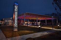
Generations Park

Opened in 2015, Generations Park features ice skating during the winter season. Ice skating season begins on Thanksgiving Day and is open daily through the beginning of March. The skating is free for all Town residents who present a B-Rec pass. A nominal fee is charged for non-residents. Throughout the rest of the year, Generations Park is home to the After Dark at Gen Park concert and movie series, the Harris Concert series, and other events.

Sandy Bottom Par-3 and Mini-Golf

Located at 610 East College St., Sandy Bottom Park is home to Bridgewater's Par-3 nine-hole golf course, and an 18-hole miniature golf course. The park facilities also include a practice green, restrooms, several picnic tables, two gazebos, and ample parking. The Par-3 and Mini-Golf remain open from April 1 through October 31. The courses are free for all Town residents who present a B-Rec pass. A nominal fee is charged for non-residents. Mini-Golf is also available for private parties.

Oakdale Park

The biggest and busiest of the town parks, Oakdale is home to our Summer's End Celebration as well as the North River Library and the Bridgewater Little League Program. The park has three picnic areas (Shelter Nos. 1 and 2 each have 10 tables, and Shelter No. 3 has 16 tables with restroom facilities attached). Park amenities include a basketball court, two playgrounds (one for preschool children, the other for school-aged children), BBQ grills and water spigots at the shelters, four horseshoe pits, plenty of off-street parking, and open areas to run and play. Baseball field #4 is available for public use.

Other park features

  • Bridgeview Park: home to quarter mile fitness walking trail, children's fitness center, and riverfront bench swings.
  • Seven Bridges: features riverfront swings, a gazebo, and commemorative signs marking some of Bridgewater's Civil War history.
Downrush Vista at Wildwood Park Downrush Vista.jpg
Downrush Vista at Wildwood Park
  • Edgebriar Park: has a handicap-accessible fishing pier, backgammon and chess inlaid game tables, and a water garden with a waterfall and a variety of fish and plants.
  • Wildwood Park: allows fishing and includes a playground, picnic shelter, BBQ grill, and a platform called Downrush Vista overlooking the North River.
  • Wynant Park: this small pocket park has a playground, hammock, and picnic table.
  • Bird Sanctuary: with 3/4 of an acre, this park has quiet seclusion and shelter provided by trees and shrubs for bird watching.
  • Dinkel-Harris Gateway at Warm Springs Turnpike Park: details the historical significance of what was once known as the Warm Springs Turnpike.
  • Cooks Creek Arboretum: this eight-acre park includes many trees planted by Bridgewater's Turner Ashby High School students, a walking path, and several picnic tables.
  • Harrison Park: home to the Doug Will Tennis Center with two indoor tennis courts, two pickleball courts as well as a full basketball court and playground.
  • Whitelow Park: named for Bridgewater resident Carlyle Whitelow, this park includes a walking trail, play structure, and swing set.
Sipe Center, 100 North Main Street Sipe Center.jpg
Sipe Center, 100 North Main Street

Sipe Center

In November 2019, the Town of Bridgewater opened Sipe Center. Located at 100 North Main Street, Sipe Center is a state-of-the-art movie theater and performing arts center, with a seating capacity of 154. Formerly a storefront, the Town purchased the deteriorated historic 19th-century W.H. Sipe Company, Inc building in 2017 and demolished it due to numerous structural issues. The Sipe Center, which replaced the old building, is an entirely new purpose-built multi-use theater with some exterior elements inspired by the original Sipe building. Sipe Center hosts approximately two live performances every month, from productions of Shakespeare, magic shows and live music. The Town Council meetings are also held at Sipe Center.

See also

Related Research Articles

<span class="mw-page-title-main">Jackson County, Michigan</span> County in Michigan, United States

Jackson County is located in the U.S. state of Michigan. The population of the county was 160,366 as of the 2020 Census. Its seat of government is the city of Jackson. The county was set off in 1829 and organized in 1832. It is named for U.S. President Andrew Jackson and considered to be one of Michigan's "Cabinet counties", named for members of Jackson's Cabinet.

<span class="mw-page-title-main">Rockingham County, Virginia</span> County in Virginia, United States

Rockingham County is a county located in the U.S. state of Virginia. As of the 2020 census, the population was 83,757. Its county seat is the independent city of Harrisonburg.

<span class="mw-page-title-main">Harrisonburg, Virginia</span> Independent city in Virginia, United States

Harrisonburg is an independent city in the Shenandoah Valley region of the Commonwealth of Virginia in the United States. It is also the county seat of the surrounding Rockingham County, although the two are separate jurisdictions. At the 2020 census, the population was 51,814. The Bureau of Economic Analysis combines the city of Harrisonburg with Rockingham County for statistical purposes into the Harrisonburg, Virginia Metropolitan Statistical Area, which had an estimated population of 126,562 in 2011.

<span class="mw-page-title-main">Colonial Heights, Virginia</span> Independent city in Virginia, United States

Colonial Heights is an independent city in the Commonwealth of Virginia. As of the 2020 census, the population was 18,170. The Bureau of Economic Analysis combines the City of Colonial Heights with Dinwiddie County for statistical purposes.

<span class="mw-page-title-main">Hinsdale, Illinois</span> Village in the US State of Illinois

Hinsdale is a village in Cook and DuPage counties in the U.S. state of Illinois. Hinsdale is a western suburb of Chicago. The population was 17,395 at the 2020 census, most of whom lived in DuPage County.

<span class="mw-page-title-main">La Porte, Indiana</span> City in Indiana, United States

La Porte is a city in LaPorte County, Indiana, United States, of which it is the county seat. Its population was estimated to be 21,341 in 2022. It is one of the two principal cities of the Michigan City-La Porte, Indiana metropolitan statistical area, which is included in the Chicago–Naperville–Michigan City, Illinois–Indiana–Wisconsin combined statistical area.

<span class="mw-page-title-main">Oelwein, Iowa</span> City in Iowa, United States

Oelwein is a city in Fayette County, Iowa, United States. The population was 5,920 at the time of the 2020 census, a decrease of 11.5% from the 2000 census. The largest community in Fayette County, it is located at the junction of State Highways 3 and 150.

<span class="mw-page-title-main">Webster City, Iowa</span> City in Iowa, United States

Webster City is a city in Hamilton County, Iowa, United States. The population was 7,825 at the 2020 census. It is the county seat of Hamilton County. Webster City is known as 'Boone River Country', as the Boone River meanders along the east side of the city.

<span class="mw-page-title-main">Loup City, Nebraska</span> City in Sherman County, Nebraska, United States

Loup City is a city in and the county seat of Sherman County, Nebraska, United States. The population was 1,173 at the 2010 census. Loup City is close to the Middle Loup River, and about 5 miles (8.0 km) from Sherman Reservoir.

<span class="mw-page-title-main">Farmville, North Carolina</span> Town in North Carolina, United States

Farmville is a town in Pitt County, North Carolina, United States, eight miles to the west of Greenville. At the 2010 Census, the population was 4,654. Farmville is a part of the Greenville Metropolitan Area located in North Carolina's Inner Banks region. Farmville has been a Tree City USA community through the Arbor Day Foundation for 36 years, proving its commitment to managing and expanding its public trees. The Town government, in cooperation with other non-profit groups that work for the advancement of the town, sponsor annual events such as the Farmville Dogwood Festival, the Christmas Parade, Independence Day Celebration, A Taste of Farmville, and the Holiday Open House, among others.

<span class="mw-page-title-main">Dayton, Virginia</span> Town in Virginia, United States

Dayton is a town in Rockingham County, Virginia, United States. The population is 1,530 as of the 2010 census. It is included in the Harrisonburg, Virginia Metropolitan Statistical Area.

<span class="mw-page-title-main">St. Peters, Missouri</span> City in east central Missouri, U.S.

St. Peters is a city in St. Charles County, Missouri, United States. The population was 57,732 at the 2020 census, making it the eleventh-largest city in Missouri. It is a northwestern suburb of St. Louis.

<span class="mw-page-title-main">Kingwood, Houston</span> Community of Houston and Master planned area in Texas, United States

Kingwood is a 14,000-acre (57 km2) master-planned community located in northeast Houston, Texas, United States. The majority of the community is located in Harris County with a small portion in Montgomery County. Known as the "Livable Forest," it is the largest master-planned community in Harris County and second-largest within the 10-county Houston-The Woodlands-Sugar Land metropolitan area. It was classified as a "census-designated place" during the 1990 census, when the population recorded was 37,397. It is on the east fork of the San Jacinto River.

The Albany Parks & Recreation is a city agency in AlbanyAlbany, Oregon, United States responsible for maintaining the local city parks as well as organizing cultural events. Its headquarters are at City Hall, 333 Broadalbin Street SW. One goal of the City of Albany is to have all residents live within 2 miles (3 km) of a park.

<span class="mw-page-title-main">Vanderhoof, British Columbia</span> District municipality in British Columbia, Canada

Vanderhoof is a district municipality near the geographical centre of British Columbia, Canada. Covering 2.92 square kilometers, it has a population of about 4,500 within town limits, and offers services to nearly 10,000 people in nearby rural communities. Its main industries are forestry, agriculture, and related businesses. Tourism is also growing, and mining operations are being developed in the area. It has many elementary schools, and one major secondary school, Nechako Valley Secondary School (NVSS), comprising School District 91 Nechako Lakes. The College of New Caledonia has a regional campus there.

<span class="mw-page-title-main">Recreation in Huntington, West Virginia</span>

Huntington is home to eleven parks located in the neighborhoods of Huntington. An amusement park is also adjacent to the city.

<span class="mw-page-title-main">Bentleigh East</span> Suburb of City of Glen Eira, Victoria, Australia

Bentleigh East is a suburb in Melbourne, Victoria, Australia, 14 km (8.7 mi) south-east of Melbourne's Central Business District, located within the City of Glen Eira local government area. Bentleigh East recorded a population of 30,159 at the 2021 census.

Virginia Beach, Virginia is a city that has become a popular tourist destination in recent years on account of its historical, scientific, and performing arts.

<span class="mw-page-title-main">Claremore Lake</span>

Claremore Lake is a reservoir in Rogers County, Oklahoma. Constructed in 1929–1930 by damming Dog Creek for the purpose of providing water to the city of Claremore, Oklahoma and houses recreational amenities such as boat ramps, fishing docks, and picnic areas. In 2011, the lake added a 9-hole disc golf course.

<span class="mw-page-title-main">Buck Creek (Kent County, Michigan)</span> River in Grandville, United States

Buck Creek is a 20.3-mile-long (32.7 km) tributary of the Grand River in Kent and Allegan counties in the U.S. state of Michigan. It rises in northern Allegan County in Byron and Gaines townships, and flows through the cities of Kentwood and Wyoming as an urban stream to enter the Grand River in Grandville. The Grand River is a tributary of Lake Michigan.

References

  1. "2019 U.S. Gazetteer Files". United States Census Bureau. Retrieved August 7, 2020.
  2. 1 2 U.S. Geological Survey Geographic Names Information System: Bridgewater, Virginia
  3. 1 2 3 "QuickFacts Bridgewater Town Virginia". United States Census Bureau . Retrieved November 3, 2022.
  4. 1 2 Holton, Bob F.; Loveless, Carleen (2010). Bridgewater. Charleston, SC: Arcadia Publishing. p. 10. ISBN   978-0738586502.
  5. "Charter - Bridgewater". law.lis.virginia.gov. Commonwealth of Virginia. Retrieved May 14, 2018.
  6. "History of Bridgewater College". Bridgewater College. Archived from the original on November 10, 2017. Retrieved November 28, 2017.
  7. "About Bridgewater". Bridgewater College. Retrieved November 28, 2017.
  8. Holton & Loveless 2010, p.7.
  9. "College Town Surveys Losses". Daily News-Record . Vol. 106, no. 36. Harrisonburg, VA. June 20, 1949. p. 1.
  10. Harter, Dale (Summer 2008). "The Flood of 1949 in Bridgewater" (PDF). The Harrisonburg-Rockingham Historical Society Newsletter. 30 (3): 4. Retrieved May 14, 2018.
  11. Vanderhoek, Mark (August 29, 2003). "Town Prepares To Celebrate Summer's End". Daily News-Record . Harrisonburg, VA.
  12. Potter, Ellie (September 4, 2017). "Celebrating Summer's End". Daily News-Record . Harrisonburg, VA.
  13. "Census of Population and Housing". Census.gov. Retrieved November 3, 2022.
  14. "Virginia's 20 Safest Cities of 2020". SafeWise. March 9, 2020. Retrieved April 23, 2020.
  15. says, Jeanette Schnieders (April 7, 2020). "These Are The 10 Best Places To Live In Virginia For 2018". HomeSnacks. Retrieved April 23, 2020.