Penn Laird, Virginia

Last updated

Penn Laird, Virginia
Unincorporated community
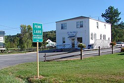
Penn Laird VA.JPG
USA Virginia location map.svg
Red pog.svg
Penn Laird, Virginia
Usa edcp location map.svg
Red pog.svg
Penn Laird, Virginia
Coordinates: 38°23′08″N78°48′09″W / 38.38556°N 78.80250°W / 38.38556; -78.80250
Country United States
State Virginia
County Rockingham
Elevation
1,204 ft (367 m)
Time zone UTC-5 (Eastern (EST))
  Summer (DST) UTC-4 (EDT)
ZIP code
22846
Area code 540
GNIS feature ID1496071 [1]

Penn Laird is an unincorporated community in Rockingham County, Virginia, United States.

Contents

Geography

Penn Laird is located on U.S. Route 33 5.7 miles (9.2 km) southeast of Harrisonburg.

Rockingham County VA location map.svg
Red pog.svg
Penn Laird
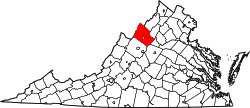
Location of Penn Laird within the Rockingham County

History

Penn Laird has a post office with ZIP code 22846, which opened on July 18, 1896. [2] [3] Ruth Kathleen Funkhouser Armstrong states the name Penn Laird came from the two middle names of Harold Roudabush's father, William Penn Roudabush and Harold's Wife father, whose middle name was Laird.

Related Research Articles

<span class="mw-page-title-main">ZIP Code</span> Numeric postal code used in the United States and its territories

A ZIP Code is a system of postal codes used by the United States Postal Service (USPS). Introduced on July 1, 1963, the basic format consisted of five digits. In 1983, an extended ZIP+4 code was introduced; it included the five digits of the ZIP Code, followed by a hyphen and four digits that designated a more specific location.

<span class="mw-page-title-main">Deepwater, New Jersey</span> Populated place in Salem County, New Jersey, US

Deepwater is an unincorporated community located within Pennsville Township, in Salem County, in the U.S. state of New Jersey. The community is located at the east end of the Delaware Memorial Bridge. Deepwater is the location of the United States Postal Service area covering ZIP code 08023. At the 2000 census, the ZCTA had a population of 345.

<span class="mw-page-title-main">Swoope, Virginia</span> Unincorporated community in Virginia, United States

Swoope is an unincorporated community in Augusta County, Virginia. Swoope is located on State Routes 703 and 860 7.4 miles (11.9 km) west of Staunton. Swoope has a post office with ZIP code 24479, which opened on March 6, 1838. Polyface Farm, a sustainable farm run by Joel Salatin, is also near Swoope. Students in the area go to Beverley Manor Elementary School, Churchville Elementary School, attend Beverley Manor Middle School, and Buffalo Gap High School.

<span class="mw-page-title-main">Laird, Colorado</span> Unincorporated community in Colorado, United States

Laird is an unincorporated community and a census-designated place (CDP) located in and governed by Yuma County, Colorado, United States. The population of the Laird CDP was 46 at the United States Census 2020. The Wray post office (Zip Code 80758) serves Laird postal addresses. Laird has the lowest elevation of any community in Colorado at 3,402 feet (1,037 m).

Ellamore is an unincorporated community in Randolph and Upshur counties, West Virginia, United States. Ellamore is located on County Route 151 along the Middle Fork River, 8 miles (13 km) southeast of Buckhannon. Ellamore had a post office, which closed on July 11, 2009.

Hatchechubbee is an unincorporated community in Russell County, Alabama, United States. Hatchechubbee is located at the junction of Alabama State Route 26 and County Route 65, 6.5 miles (10.5 km) west-southwest of Seale. Hatchechubbee has a post office with ZIP code 36858, which opened on August 17, 1855. The community's name is derived from the Creek words hachi meaning "creek" and chaba meaning "halfway".

<span class="mw-page-title-main">Hartfield, Virginia</span> Unincorporated community in Virginia, United States

Hartfield is an unincorporated community in Middlesex County, Virginia, United States. Hartfield is located at the junction of Virginia State Route 3 and Virginia State Route 33, 9 miles (14 km) east-southeast of Saluda. Hartfield has a post office with ZIP code 23071, which opened on September 5, 1889.

<span class="mw-page-title-main">Belfry, Kentucky</span> Unincorporated community in Kentucky, United States

Belfry is an unincorporated community in Pike County, Kentucky. Belfry is located on U.S. Route 119, 16.8 miles (27.0 km) northeast of Pikeville. Belfry has a post office with ZIP code 41514, which opened on February 26, 1921. The origin of the name "Belfry" is obscure.

<span class="mw-page-title-main">Evensville, Tennessee</span> Unincorporated community in Tennessee, United States

Evensville is an unincorporated community in Rhea County, Tennessee, United States. In 2020 the population was 2,624. Evensville is located along U.S. Route 27 5.8 miles (9.3 km) northeast of Dayton. Evensville has a post office with ZIP code 37332. Rhea County High School is located in Evensville.

<span class="mw-page-title-main">Christiana, Tennessee</span> Census-designated place in Tennessee, United States

Christiana is an unincorporated community and census-designated place in Rutherford County, Tennessee, United States. It has a post office, with ZIP code 37037. Christiana Middle School is located in the community. Both U.S. Route 231 and Tennessee State Route 269 pass through the community.

<span class="mw-page-title-main">Coleman Falls, Virginia</span> Unincorporated community in Virginia, United States

Coleman Falls is an unincorporated community in northern Bedford County, Virginia, United States. The community is located along the James River and U.S. Route 501, between Big Island and Boonsboro. It is part of the Lynchburg Metropolitan Statistical Area.

Lowry is an unincorporated community in eastern Bedford County, Virginia, United States. The community is located along State Route 715 and is 5.2 miles (8.4 km) east-northeast of Bedford. It is part of the Lynchburg Metropolitan Statistical Area.

Zirconia is an unincorporated community in Henderson County, North Carolina, United States. Zirconia is located on North Carolina Highway 225, 5.9 miles (9.5 km) south-southeast of Hendersonville. Zirconia has a post office with ZIP code 28790, which opened on June 9, 1853. The community was named for the valuable deposits of zircon in the area.

South Seaville is an unincorporated community located within Dennis Township in Cape May County, in the U.S. state of New Jersey. South Seaville is 4 miles (6.4 km) northwest of Sea Isle City. South Seaville has a post office with ZIP Code 08246.

<span class="mw-page-title-main">Continental Divide, New Mexico</span> Unincorporated community in McKinley County, New Mexico, United States

Continental Divide is an unincorporated community in McKinley County, New Mexico, United States.

Rehoboth is an unincorporated community in McKinley County, New Mexico, United States. Rehoboth is located along Interstate 40, 5 miles (8.0 km) east of downtown Gallup. Rehoboth has a post office with ZIP code 87322. It has a population of 56 permanent residents.

Penn Run is an unincorporated community in Indiana County, Pennsylvania, United States. The community is located along Pennsylvania Route 553, 7.5 miles (12.1 km) east of Indiana. Penn Run has a post office with ZIP code 15765, which opened on June 13, 1839.

Middle Falls is a hamlet within the town of Greenwich in Washington County, New York, United States. The community is located along New York State Route 29 1.5 miles (2.4 km) north-northwest of Greenwich. Middle Falls has a post office with ZIP code 12848, which opened on January 12, 1832.

Middle Granville is a hamlet in Washington County, New York, United States. The community is located at the intersection of New York State Route 22 and New York State Route 22A 2.1 miles (3.4 km) northwest of the village of Granville. Middle Granville has a post office with ZIP code 12849.

Bellona is a hamlet in Yates County, New York, United States. The community is 6.9 miles (11.1 km) north-northeast of Penn Yan. Bellona has a post office with ZIP code 14415, which opened on May 14, 1816.

References

  1. "Penn Laird". Geographic Names Information System . United States Geological Survey, United States Department of the Interior.
  2. United States Postal Service (2012). "USPS - Look Up a ZIP Code" . Retrieved February 15, 2012.
  3. "Postmaster Finder - Post Offices by ZIP Code". United States Postal Service . Retrieved May 30, 2012.