Fulks Run | |
---|---|
Coordinates: 38°39′24″N78°53′59″W / 38.65667°N 78.89972°W Coordinates: 38°39′24″N78°53′59″W / 38.65667°N 78.89972°W | |
Country | United States |
State | Virginia |
County | Rockingham County |
Elevation | 354 m (1,161 ft) |
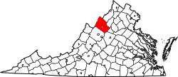
Fulks Run is an unincorporated community located in Rockingham County, Virginia, United States. [1] It is located north of Harrisonburg and south of Bergton just to the west of Broadway on route 259, near the border of West Virginia and the edge of George Washington National Forest. The North Fork Shenandoah River flows past the community. It includes Fulks Run Elementary School. The Fulks Run Ruritan Park is a popular get together spot with a baseball field.
Fulks Run would have been inundated by the reservoir of the Brocks Gap Dam, proposed in the 1940s and 1960s. Determined local opposition defeated the dam project. [2] [3]
The Potomac River drains the Mid-Atlantic United States, flowing from the Potomac Highlands into Chesapeake Bay. It is 405 miles (652 km) long, with a drainage area of 14,700 square miles (38,000 km2), and is the fourth-largest river along the East Coast of the United States and the 21st-largest in the United States. Over 5 million people live within its watershed.
The Tioga River is a tributary of the Chemung River, approximately 58 miles (93 km) long, in northern Pennsylvania and western New York in the United States. It drains a region of ridges in the northern Allegheny Plateau in the watershed of the Susquehanna River. It is a Northern flowing river
The Shenandoah River is the principal tributary of the Potomac River, 55.6 miles (89.5 km) long with two forks approximately 100 miles (160 km) long each, in the U.S. states of Virginia and West Virginia. The river and its tributaries drain the central and lower Shenandoah Valley and the Page Valley in the Appalachians on the west side of the Blue Ridge Mountains, in northwestern Virginia and the Eastern Panhandle of West Virginia. There is a hydroelectric plant along the Shenandoah river constructed in 2014 by Dominion.
Lake Oahe is a large reservoir behind Oahe Dam on the Missouri River; it begins in central South Dakota and continues north into North Dakota in the United States. The lake has an area of 370,000 acres (1,500 km2) and a maximum depth of 205 ft (62 m). By volume, it is the fourth-largest reservoir in the US. Lake Oahe has a length of approximately 231 mi (372 km) and has a shoreline of 2,250 mi (3,620 km). 51 recreation areas are located along Lake Oahe, and 1.5 million people visit the reservoir every year. The lake is named for the 1874 Oahe Indian Mission.
Jennings Randolph Lake is a reservoir of 952 acres (3.85 km2) located on the North Branch Potomac River in Garrett County, Maryland and Mineral County, West Virginia. It is approximately eight miles upstream of Bloomington, Maryland, and approximately five miles north of Elk Garden, West Virginia.
The Savage River is a 29.5-mile-long (47.5 km) river in Garrett County, Maryland, and is the first major tributary of the North Branch Potomac River from its source. The river was named for 18th century surveyor John Savage.
State Route 259 is a primary state highway in the U.S. state of Virginia. The state highway runs a total of 26.80 miles (43.13 km) in two sections. The southern section, in northern Rockingham County, has a length of 21.81 miles (35.10 km) from Interstate 81 (I-81) and U.S. Route 11 at Mauzy through Broadway to the West Virginia state line into Mathias. The northern section, in western Frederick County, covers 4.99 miles (8.03 km) from the West Virginia state line north to US 50 at Gore. The two sections of SR 259 are joined by West Virginia Route 259.
Bluestone Lake is a flood control reservoir located on the New River near Hinton, West Virginia. At its normal pool level, Bluestone Dam impounds a 10.7-mile (17.2 km) stretch of the New and its tributary, the Bluestone River. Normally approximately 2,040 acres (8.3 km2) in size, the lake can grow to over 36 miles (58 km) long at flood control pool. At higher water levels, the lake extends into Giles County, Virginia.
Kerr Lake /kɑr/ is a reservoir along the border of the U.S. states of North Carolina and Virginia. It is impounded by the John H. Kerr Dam, constructed between 1947 and 1952 to produce hydroelectricity and to provide flood control. Kerr Lake is owned by the US Army Corps of Engineers, and is the largest reservoir in Virginia. It is located in parts of Vance, Granville, and Warren counties in North Carolina, and Mecklenburg, Charlotte, and Halifax counties in Virginia. At its maximum capacity, it is one of the largest reservoirs in the Southeastern United States, covering approximately 50,000 acres (200 km2) and bordered by over 850 miles (1,370 km) of shoreline. The lake is named for Congressman John H. Kerr of North Carolina, who supported the original creation of the lake.
The Bear River is a tributary of the Feather River in the Sierra Nevada, winding through four California counties: Yuba, Sutter, Placer, and Nevada. About 73 miles (117 km) long, the river flows generally southwest through the Sierra then west through the Central Valley, draining a narrow, rugged watershed of 295 square miles (760 km2).
Cootes Store is an unincorporated community in Rockingham County, Virginia, United States. Located in the Shenandoah Valley, it is situated north of Harrisonburg, south of Bergton, and west of Timberville. The border with West Virginia is nearby, as is the edge of George Washington National Forest. Cootes Store is within a gorge where the North Fork Shenandoah River breaks, at the crossroads of Route 613 and Route 259.
Brocks Gap Dam was a never-built proposal for a water storage dam on the North Fork of the Shenandoah River at Brocks Gap in northwest Virginia. The proposal by the U.S. Army Corps of Engineers encountered opposition from local residents and was withdrawn in 1967.
Tygart Dam — also known as Tygart River Dam — is a dam built and operated by the United States Army Corps of Engineers in Taylor County, West Virginia, United States. The dam regulates the waters of the Tygart Valley River. Its storage reservoir is known as Tygart Lake. Most of the lakeshore is occupied by Tygart Lake State Park and Pleasant Creek Wildlife Management Area. The structure was listed on the National Register of Historic Places in 1995.
Kanopolis Lake is a reservoir in Ellsworth County in the Smoky Hills of central Kansas, about 31 miles southwest of Salina and a few miles southeast of the town of Kanopolis. The lake is formed by Kanopolis Dam. Completed in 1948 as a flood control and water conservation project of the United States Army Corps of Engineers, the dam impounds the Smoky Hill River.
Brocks Gap is a water gap in Rockingham County, Virginia, where the North Fork of the Shenandoah River flows through Little North Mountain. The gap was the proposed site of the never-built Brocks Gap Dam and is traversed by Virginia Route 259.
Seneca Dam was the last in a series of dams proposed on the Potomac River in the area of the Great Falls of the Potomac. Apart from small-scale dams intended to divert water for municipal use in the District of Columbia and into the Chesapeake and Ohio Canal, no version of any scheme was ever built. In most cases the proposed reservoir would have extended upriver to Harpers Ferry, West Virginia. The project was part of a program of as many as sixteen major dams in the Potomac watershed, most of which were never built.
The Potomac River basin reservoir projects were U.S. Army Corps of Engineers programs that sought to regulate the flow of the Potomac River to control flooding, to assure a reliable water supply for Washington, D.C., and to provide recreational opportunities. Beginning in 1921 the Corps studied a variety of proposals for an ambitious program of dam construction on the Potomac and its tributaries, which proposed as many as sixteen major dam and reservoir projects. The most ambitious proposals would have created a nearly continuous chain of reservoirs from tidewater to Cumberland, Maryland. The 1938 program was focused on flood control, on the heels of a major flood in 1936. The reformulated 1963 program focused on water supply and quality, mitigating upstream pollution from sewage and coal mine waste.
Little Stony Creek is a 6.8 mile long river in the George Washington and Jefferson National Forests in the Commonwealth of Virginia. It is a first-order tributary of the North Fork Shenandoah River and the Potomac River.